


Publicado
Quantification of the effect of precipitation as a triggering factor for landslides on the surroundings of Medellín – Colombia
DOI:
https://doi.org/10.15446/dyna.v81n187.40640Palabras clave:
landslides triggered by rainfall, frequency-size statistics, tropical regions, natural hazards. (es)
Descargas
https://doi.org/10.15446/dyna.v81n187.40640
Quantification of the effect of precipitation as a triggering factor for landslides on the surroundings of Medellín - Colombia
Cuantificación del efecto de la precipitación como factor detonante de deslizamientos en los alrededores de Medellín - Colombia
Estefanía Muñoz a, Hernán Martínez-Carvajal b, Jorge Arévalo c & Daniel Alvira d
a Universidade de Brasília, estefaniamunozh@gmail.com
b Departamento de Ing. Civil
y Ambiental, Universidade de Brasília, Brasil. Facultad de Minas, Universidad
Nacional de Colombia,, carvajal@unb.br
c Geo 2 S.A.S., jorge.geo2@gmail.com
d Universidad Nacional de
Colombia, alvira1089@gmail.com
Received: November 1th, de 2013. Received in revised form: July 3th, 2014. Accepted: July 17th, 2014
Abstract
Malamud et al. [7]
presented a theoretical function that explains the relationship between the
area of landslides associated to a certain triggering event (heavy rainfall, snow
melting, earthquake) and its frequency. This probability density function was
applied to a landslides inventory mapped outside the city of Medellín,
distinguishing between landslides (in natural slopes) and slope failures (so
called man-made slopes). As a result, the statistic behavior of large
landslides is very similar to the theoretical curve presented by the authors
referred above, while the probability of occurrence of small landslides, those
with areas smaller than 5x10⁻⁴ km2, is much higher,
especially on man-made slope failures. Considering that this behavior is
clearly manifested on man-made slope failures, it can be inferred that there is
an effect of the road on the increase of the periodicity of the slides and there
for, the popular hypothesis of associating road slope failure only to
precipitation is questionable.
Keywords: landslides triggered by rainfall, frequency-size statistics, tropical regions, natural hazards.
Resumen
Malamud et al. [7] presentaron una función teórica que relaciona la densidad de
probabilidad de los deslizamientos con su área. Para verificar la validez de
esta función en el ambiente montañoso andino de los alrededores de Medellín -
Colombia, se recolectó un inventario de deslizamientos en las afueras de la
ciudad, diferenciando entre los ocurridos en laderas rurales y taludes viales.
Se obtuvo como resultado, que el comportamiento estadístico de los
deslizamientos de áreas grandes es muy similar a la curva teórica presentada
por los referidos autores, mientras que la probabilidad de ocurrencia de
deslizamientos con áreas menores a 5x10⁻⁴ km2 es mucho mayor,
especialmente en los de los taludes viales. Teniendo en consideración que este
comportamiento se manifestó de manera clara en taludes viales, puede inferirse
que existe un efecto de la vía en el aumento de la frecuencia de deslizamientos
y de esta forma, la hipótesis popular de asociar las fallas de taludes de
carreteras apenas al efecto de las lluvias es cuestionable.
Palabras clave: deslizamientos detonados por lluvias, relación estadística frecuencia-tamaño, regiones tropicales, amenazas naturales.
1. Introduction
The mass movements are part of the most common natural disasters around the world, bringing along great economic and human losses. This phenomenon happens for many reasons, some of them are geological, geomorphological and the anthropic intervention [12]. They are generally associated with external inducement that rapidly increases the strains or reduces the resistance. The most common triggering factors are tectonic movements, rapid thawing or intense and long precipitations [7].
Although the landslides often affect the Colombian territory, specially the Andina region, there is not yet a complete database that allows making any kind of technical impact, environmental or social analysis [2]. The few and incomplete databases that exist are regional and don't have enough information. Therefore, it is necessary to develop methods that allow obtaining the probability of landslides, considering variables that are easy to know, such as geomorphology, geology and geometry of the slope.
This work pretends to assess the universality of the probability distribution of landslides according to their area, proposed by Malamud et al. [7], through the adjustment of an incomplete historic database, taken in different roads and rural hillsides located outside Medellín, Colombia.

Moreover, analyze the behavior of the events that affect the referred region.
2. Study Area
The study area is located south of the department of Antioquia, northwest of Colombia.
The data was collected in four roads located outside Medellín and nearby hillsides, as shown in. The roads where: (i) The Medellín - Bogotá Highway, northeast of Medellín, connect this city with the capital of the country. The section in which the data was taken goes through the townships of Bello, Copacabana and Guarne. (ii) Road to the West, known as West Tunnel road link, connects Medellín with the Urabá region, where an important maritime terminal is located. The considered sector goes through Medellín and San Jerónimo. (iii) The Amagá road connects Medellín with the municipality of Amagá and the considered sector goes through Itagüí, La Estrella, Sabaneta and Caldas, municipalities located southeast from Medellín. Last, (iv) Las Palmas road, is one of the routes to access the east of Antioquia, where the José María Córdoba airport is located. This section goes through the municipalities of Envigado and part of El Retiro.
The municipalities where the information was taken have an average annual precipitation that ranges between 1500 mm and 3000 mm, and an average height between 780 m.a.s.l (meters above sea level) and 2175 m.a.s.l [1].
3. Methods
A field campaign was made to collect area measurements from the landslides occurred on the roads mentioned above as well as from the nearby hillsides.
The measurements taken were: Height of the landslide (z), width (y) and depth (x), as shown on Figure 2.

The areas estimated correspond to the inclined surface of the landslides, obtained from the measurements mentioned above. Only the areas corresponding to the tear portion of the slide where taken in consideration, and not the accumulation areas.
The inventory obtained was divided in order to differentiate the landslides occurred on hillsides and the ones occurred on man-made slope failures. Fig. 3 shows the pictures of some of the landslides taken on the slope failures, showing their different magnitudes.

The intervals to classify the areas within categories where defined deciding the range of probable areas (10-5 km2 - 10-1 km2) according to the Sturges' Rule, which says that the number of classes to be considered to elaborate a histogram depends on the size of information held (data base), following the eq. (1).

Where c is the number of classes and n is the amount of data.
Then, each of the areas was assigned to its correspondent interval, obtaining the probability density function of occurrence of each of them (Table 1), according to eq. (2).

Where,  is the probability function,
  is the total amount of landslides,
  the number of data on the interval and
  the interval width.

The probability density functions of the areas of landslides occurred on different places in the world and triggered by different factors, present a very similar tendency, adjusting to an inverse gamma probability distribution of three parameters, given by eq. (3), [7].

Where  is the gamma function and the three parameters
a, s and
is the gamma function and the three parameters
a, s and  are coefficients that influence the
distribution's form. The parameter controls the decline of the power law for the
areas of big and medium mass movements, the parameter a controls the location of the maximum value of the probability
distribution, and the parameter s controls the exponential fall of the small landslides zones. Furthermore, the
parameters shown in Table 2 were defined as the values that best fit the
outcomes obtained.
are coefficients that influence the
distribution's form. The parameter controls the decline of the power law for the
areas of big and medium mass movements, the parameter a controls the location of the maximum value of the probability
distribution, and the parameter s controls the exponential fall of the small landslides zones. Furthermore, the
parameters shown in Table 2 were defined as the values that best fit the
outcomes obtained.


In order to verify the distribution adjustment described above to the statistic behavior of the areas of the mass movements collected, in a logarithmic graph the theoretical distribution was made and the probability density data were overlapped, as shown in Fig. 2.
In order to verify the distribution adjustment described above to the statistic behavior of the areas of the mass movements collected, in a logarithmic graph the theoretical distribution was made and the probability density data were overlapped, as shown in Fig. 2.
With
all the information gathered, it was possible to pose a magnitude scale for a
specific event of rainfall that deflagrates landslides. This scale must be able
to describe any characteristic of the event related to its capacity to trigger
mass movements; for example the number of probable landslides as proposed by
Malamud et al, [7] having as a base the idea used since the 1980's for
inventory surveys of landslides deflagrated by earthquakes. The magnitude was then
defined and in a simple way, as the base-10 logarithm of the total number of
landslides ( ). In this way, the relation
between the magnitude and the probability density function of the areas of the
landslides shown in eq. (2) is direct.
). In this way, the relation
between the magnitude and the probability density function of the areas of the
landslides shown in eq. (2) is direct.
Fig. 3 shows the theoretical curves of frequency density against de landslide area for different magnitudes, as well as the points correspondent to the field data survey, ergo, the inventory of landslides of this work.

4. Analysis
Fig. 2 shows the result obtained when comparing the probability density of the data survey and the theoretical distribution. It is possible then, to appreciate that the data correspondent to all of the landslides, adjust well on the right end of the theoretical curve correspondent to big areas, ergo, for landslides bigger than 5x10⁻⁴ km2. In contrast, for landslides with areas smaller than those indicated before, the probability densities are bigger than the theoretical.
Given that the theoretical distribution has been verified for a wide variety of inventory of landslides deflagrated by different types of events, intense precipitation [3], earthquakes [6], rapid thawing [4], it is hard to explain the great difference between the theoretical values and the data collected on the field for small areas (AL<5x10⁻⁴km2) merely with the argument of the non-universality of the theoretical distribution. The techniques used for the collection of the landslides inventory of the references found on the literature [8-11] are based exclusively on remote sensing whose resolution hinders the collection of smaller landslides. Thus, the inventories are usually complete for landslides with big areas and incomplete for those of small areas. Consequently, it is expected that when the theoretical distribution is compared to the data of an inventory made on the field, the first presents a smaller frequency for the small landslides that are, precisely, identified with great accuracy in the process of direct cartography presented here. However, the difference between the theoretical and the real values is so big for the smaller areas, that it is fit to achieve a more forceful explanation to the phenomenon.
Considering that, as mentioned before, the inventory for this paper was taken along of four different roads in the vicinity of Medellín, all of them with a significant history of slope instability and in many cases crossing slopes with geological/geotechnical predisposition to show stability problems, it is reasonable to indicate that precisely the anthropic action is responsible for the increase on the frequency of occurrence of small area landslides. The cutting on the roads, made without the appropriate geotechnical attention on lands with predisposition to instability, would be increasing the frequency of landslides opposite to the number expected only by the effect of precipitations.
Looking to verify this hypothesis, also on Fig. 2, the data taken on slope failure and rural hillsides was plotted. Thus, is possible to observe that the data taken on the field for hillsides are very close to the theoretical distribution. In contrast, the data taken for slope failure remains well above the theoretical values indicated by de Gamma distribution.
The distribution correspondent to mass movements on rural hillsides shows a tendency very similar to the theoretical, but remains a small difference on the small areas zone, perhaps explained, and as mentioned above, by the greater grade of detail of the field survey made for this paper, that allows the identification of almost all of the small landslides. The divergence between the theoretical values and the values taken on the field for the road landslides then seems to be explained by the anthropic negative effect that exert the road cuts on the slope stability. This observation contradicts conclusively the intuitive argument of attribute to the rainfalls the great amount of landslides on the local roads of Medellín, and maybe, of other regions on the country.
Fig. 3 shows the magnitudes correspondent to the rainfall events that triggered the landslides of the inventory taken for the purpose of this work. There are also shown, as indicated before, the theoretical magnitudes of other probable rainfall events on the region of study. The complete inventory follows an approximate magnitude of mL=2.5 for big areas, while for small areas reaches mL=4, this is, two orders of magnitude bigger, on a logarithmic scale. Therefore, when analyzing exclusively the behavior of the inventory for rural hillsides, shows that in terms of magnitude, it always remains between mL=2 and mL=3 magnitude interval.
Needless to mention that even though the inventory taken is not related to a single rainfall event, as the landslides evaluated correspond to different places and times, the magnitude indicated may be associated to the average rainfall event. In conclusion, the average rainfall events that deflagrate landslides on Medellín have variable magnitudes between mL=2 y mL=3 on the scale indicated for this work. The anthropic effect, that is to say, the geotechnical negligence, increases drastically the frequency of landslides, as shown on previous figures. Such increase would correspond, if it were one rainfall event, to the effect produced by rainfalls with magnitude mL=4, it is, two orders of magnitude greater than the real average rainfalls.
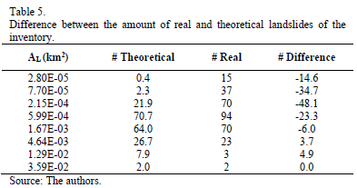
With the purpose of quantifying in terms of the number of landslides for each class of area size, theoretical quantities of road landslides and hillsides were calculated and compared to the real quantities. These results are presented on Tables 3, 4 and 5.


The more noticeable differences are given on the data taken on slope failures on roads (Table 3). The class with average value of 2.8 x 10⁻⁵ km2, it is, 28 m2, presented a frequency of 14 landslides, value that differs greatly from the theoretical that is 0,4. This difference, that in absolute terms corresponds to 13,6 landslides, indicates that the theoretical curve is two orders of magnitude bellow the real value for the class indicated. Note that for the classes with sizes greater than 6 x 10⁻⁴ km2 (600 m2) the difference between the theoretical and the real frequency is positive, it is, the theoretical curve is slightly above of the inventory points. Nevertheless, the absolute value is small in a way that is reasonable to assume that for big landslides (areas greater than approximately 600 m2) the theoretical distribution answers well to the statistic behavior of the inventory. The explanation lies on the geological nature of the materials affected by these landslides.
Lands with susceptibility to mass movements, submitted to rainfall regimes like those that characterize the city of Medellín, certainly will externalize such susceptibility with a certain number of big landslides that is independent from having or not anthropic affectations. The roads then do not increase the occurrence of big landslides but, in contrast, increase, and a lot, the frequency of occurrence of medium and small landslides. The first is a problem that can be resolved, or at least can be prevented with an accurate geological characterization of the terrain for engineering purposes, practice that is scarcer, perhaps for the lack of geological engineers or for the intense diversion of the current towards more geological topics, scientifically speaking, and less applied. The second problem can be resolved with an adequate geotechnical practice, on which, cannot be stated, in this modest work, any philosophical argument.
Table 4 presents the numbers correspondent to the inventory of rural hillsides. Although there are clear differences between the theoretical and the real values for small landslides, these are less than those observed and discussed on Table 3. The reasons have been already exposed. The field survey for this work can be considered complete for small landslides, while the theoretical function was deduced from incomplete inventory for the same type of landslides.
Table 5 presents the frequencies for the complete inventory. As discussed before, small landslides (area smaller than 600 m2) are much more frequent that indicated by the theoretical distribution, that in function of the anthropic effect represented by the road cuts.

Due to the regional nature of the rainfall events and, in contrast, the local nature of the induced landslides on roads by anthropic effects, is important to study the frequency of occurrence of this processes by a procedure that considers their concentration by unit length of road or by unit area of hillside. Initially it would be difficult to reconcile on a rigorous analysis a 2D natured event (area affected by a rainfall event that deflagrates landslides) and a 1D natured event (road as a linear work). Nevertheless, it is possible to approach to the understanding of both phenomenon considering the total length of the segments of roads studied, which is 52 km. Table 6 shows the values of the frequency of occurrence of landslides normalized by the total length of the studied roads (NL/km). For the class correspondent to the value 2.8x10⁻⁵ km2 (28 m2) a normalized frequency of 0,007 landslides by lineal km of road (theoretical value) was calculated, while the value observed was 0,269, it is, approximately 38 times bigger. For the class correspondent to the average value of 7.7x10⁻⁵ km2 (77 m2) the factor is 15 and for the class defined by the value of 2.15 x 10⁻⁴ km2 (215 m2) the factor is approximately 2. For landslides with areas bigger or equal to approximately 600 m2 the factor is on average 0,5.
5. Conclusions
Even though the inventory used is incomplete, it was possible to make a statistical management of the data using the method proposed by Malamud et al. [7], and from it, infer the statistic behavior of the landslides on the region where the data was taken using as a variable of analysis the exposed area of the landslides.
The distribution obtained with real data, was adjusted to the theoretical for areas bigger or equal to 6x10⁻⁴ km2 (600 m2), while for the smaller frequencies of real landslides is much bigger than the indicated on the theoretical distribution.
Dividing the inventory between landslides occurred on slope failures and landslides occurred on rural hillsides, allowed to notice that the second adjust much better to the theoretical distribution than the first, which can be explained by the anthropic effect. Besides, the above indicates that the big landslides, it is those that have an area bigger than 6x10⁻⁴ km2, are hardly affected by human activities.
When normalizing the frequency of occurrence of landslides by the total length of the roads studied it is concluded that:
- For landslides with average areas around 2.8x10⁻⁵ km2 (28 m2), only one of 38 landslides occurred on slope failures is caused exclusively by the natural combination of unfavorable geotechnical conditions and rainfall events.
- For landslides with average areas of 7.7x10⁻⁵ km2 (77 m2), only one of 15 landslides occurred on slope failures is caused exclusively by the natural combination of unfavorable geotechnical conditions and rainfall events.
- For landslides with average areas of 2.15x10⁻⁴ km2 (215 m2), only one of 2 landslides occurred on slope failures is caused exclusively by the natural combination of unfavorable geotechnical conditions and rainfall events.
- For landslides with average areas bigger than approximately 6x10⁻⁴ km2 to 7x10⁻⁴ km2 (600-700 m2), is not possible to impute its occurrence to anthropic action. At the most, and this has to be proven, the effect of cuts made without the proper geotechnical cares could accelerate natural processes that are already present. In this case is emphasized the importance of making detailed engineering geology studies focused on characterization (Geological/geotechnical zoning) of the terrain on stages previous to the implementation of a construction.
Considering valid the universality hypothesis of the theoretical distribution proposed by Malamud et al. [7] to explain the statistic behavior of the landslides areas on complete inventories, it can be concluded that even though there is a certain natural propensity of the hillsides of Medellín to present mass movements, is not the rainfall events that are responsible for the high number of this processes, as it is the local geotechnical practice. Small landslides are clearly deflagrated by the anthropic action, with factors of 1:38 in relation to the natural trigger (Rainfall).
References
[1] AMVA, Municipios Valle de Aburrá. Revisión sistemática, Medellín, Colombia, Área Metropolitana del Valle de Aburrá, [en línea], 2012. [date of reference July 20th of 2012]. Available at: http://www.areadigital.gov.co/institucional/Paginas/municipios.aspx.
[2] Aristizábal, E., Martínez, H. & Vélez, J.I., Una revisión sobre el estudio de movimientos en masa detonados por lluvias, Revista de la Academia Colombiana de Ciencias Exactas, físicas y Naturales, 34 (131), pp. 209-227, 2010.
[3] Bucknam, R.C., Coe, J.A., Chavarria, M.M., Godt, J.W., Tarr, A.C., Bradley, L.A. and Johnson, M.L., Landslides triggered by hurricane Mitch in Guatemala - Inventory and discussion, United States, U.S. Geological Survey, 01-0443, 2001,
[4] Cardinali, M., Ardizzone, F., Galli, M., Guzzetti, F. and Reichenbach, P., Landslides triggered by rapid snow melting: The December 1996-January 1997 event in Central Italy, plinius conference [1st, 1999, Maratea], Proceedings Plinius Conference '99, Maratea, Claps and F. Siccardi, 2012, pp. 439-448.
[5] Gobernación de Antioquia., Datos de Antioquia. Revisión sistemática, Medellín, Colombia, Gobernación de Antioquia, [en línea], 2012 [date of reference July 25th of 2012]. Available at: http://www.antioquia.gov.co/index.php/sobre-antioquia/antioquia.
[6] Harp, E.L. and Jibson, R.L., Inventory of landslides triggered by the 1994 Northridge, California earthquake, United States, U.S. Geological Survey, 1995, pp. 95-213.
[7] Malamud, B.D., Turcotte, D.L., Guzzetti, F. and Reichenbach, P., Landslide inventories and their statistical properties. Earth Surface Processes and Landforms, 29 (6), pp. 687-711, 2004.
[8] Mantovani, F., Soeters, R. and Van Westen, C.J., Remote sensing techniques for landslide studies and hazard zonation in Europe. Geomorphology, 15 (3), pp. 213-225, 1996.
[9] Nichol, J. and Wong, M.S., Satellite remote sensing for detailed landslide inventories using change detection and image fusion, International Journal of Remote Sensing, 26 (9), pp.1913-1926, 2005.
[10] Singhroy, V., Mattar, K.E. and Gray, A.L., Landslide characterisation in Canada using interferometric SAR and combined SAR and TM images, Advances in Space Research, 21 (3), pp.465-476, 1998.
[11] Van Den Eeckhaut, M., Reichenbach, P., Guzzetti, F., Rossi, M. and Poesen, J., Combined landslide inventory and susceptibility assessment based on different mapping units: an example from the Flemish Ardennes, Belgium. Natural Hazards and Earth System Science, 9 (2), pp. 507-521, 2009.
[12] Aristizábal, É. and Yokota, S., Geomorfología aplicada a la ocurrencia de deslizamientos en el Valle de Aburra. DYNA, 73 (149), pp. 5-16, 2006.
E. Muñoz-Hoyos, received the Bs. Eng. in Civil Engineering in 2012 from the Universidad Nacional de Colombia, Medellín, Colombia and the MSc. degree in Geotechnical Engineering in 2014, from the Universidade de Brasília, Brazil. From 2009 to 2012 worked for the Universidad Nacional de Colombia as a student assistant in research and extension projects. Her research interests include: rainfall-triggered landslides, numerical and probabilistic methods.
H. E. Martinez-Carvajal, received the Bs. Eng. in Geology Engineering in 1995 from the Universidad Nacional de Colombia, Medellín, Colombia; the MSc. degree in Soil Mechanics in 1999, from the Universidad Nacional Autonoma de Mexico - UNAM, Mexico and the DSc. degree in Geotechnique in 2006. from the University of Brasilia, Brazil. From 1993 to 1999 worked for civil engineering consulting companies as field geology and soil exploration. Currently is Associated professor of the Civil and Environmental Engioneering Department at the University of Brasilia, Brazil and lecturer professor at the Facultad de Minas of the Universidad Nacional de Colombia, Medellín, Colombia. Link for complete information about the author: http://lattes.cnpq.br/2409917419986324
J. A. Arévalo-Cardona, received the Bs. Eng. in Civil Engineering in 2013 from the Universidad Nacional de Colombia, Medellín. Colombia. From 2011 to 2013 he worked for the geotechnical area of INTEGRAL S.A, a civil engineering consulting company. Currently he works for GEO2 S.A.S, another geotechnical consulting company.
D. Alvira, received the Bs. Eng. in Geology Engineering from the Universidad Nacional de Colombia, Medellín. Colombia.
Cómo citar
IEEE
ACM
ACS
APA
ABNT
Chicago
Harvard
MLA
Turabian
Vancouver
Descargar cita
Licencia
Derechos de autor 2014 DYNA

Esta obra está bajo una licencia internacional Creative Commons Atribución-NoComercial-SinDerivadas 4.0.
El autor o autores de un artículo aceptado para publicación en cualquiera de las revistas editadas por la facultad de Minas cederán la totalidad de los derechos patrimoniales a la Universidad Nacional de Colombia de manera gratuita, dentro de los cuáles se incluyen: el derecho a editar, publicar, reproducir y distribuir tanto en medios impresos como digitales, además de incluir en artículo en índices internacionales y/o bases de datos, de igual manera, se faculta a la editorial para utilizar las imágenes, tablas y/o cualquier material gráfico presentado en el artículo para el diseño de carátulas o posters de la misma revista.


