


Published
The geomorphic history of the Ainoura plain, Kyushu, Japan, based on excavation of the Monzen ruins
Keywords:
alluvial plain, Hokusyo landslide, Kitamatsuura basalt, Kyushu, transgression. (en)The geomorphic history of the Ainoura plain, Kyushu, Japan, based on excavation of the Monzen ruins
Hirotsugu Mori1, Shoichi Shimoyama1 and Kazuaki Soejima2*
1 Earth and Planetary Sciences Department, Kyushu University, Fukuoka, Fukuoka, Japan. E-mail: hmori0622@gmail.com
2 Sasebo Property Research Office, Education Agency, Nagasaki Prefecture, Sasebo, Nagasaki, Japan
Record
Manuscript received: 14/10/2011 Accepted for publications: 06/05/2012
ABSTRACT
The complex coastline of north-western Kyushu, Japan, consisting of cliffs, steep-sided inlets and archipelagos, has resulted from subsidence in mountainous terrain; the region’s populated river valleys, having narrow alluvial plains, often suffer rock avalanches. The Ainoura plain is one such alluvial plain. Excavation of the Monzen ruins on the Ainoura Plain by the Nagasaki Prefectural Board of Education has revealed the plain’s geomorphic history regarding how the gravels and associated muds and sands were deposited during the last several thousand years. Regarding alluvial succession, mud and sand first filled in the trough, possibly as part of the transgression caused by the Holocene climatic optimum, and gravel later began to replace parts of the sand and mud layers by successive erosion and sedimentation, thereby raising riverbed level. It was confirmed that such conglomerate from the Ainoura plain was derived from the Hokusho landslide area in the hinterland because there is no conglomerate layer in the Hino plain (a small plain southeast of the Ainoura plain). The Ainoura River’s thalweg shows that the Monzen ruins are located at a sudden reduction in its gradient, thereby accounting for the thickness of coarse clastic material in that area. The reconstructed Ainoura plain’s paleoshoreline during the Holocene climatic optimum is also reported. The paleoshoreline did not move much until people began to reclaim land; it would thus be expected that the similar deposition would happened on the Ainoura plain inside this paleoshoreline.
Keywords: alluvial plain, Hokusyo landslide, Kitamatsuura basalt, Kyushu, transgression.
RESUMEN
La compleja línea de costa en la región noroccidental de Kyushu, Japón, está compuesta por acantilados, ensenadas de laderas inclinadas y archipiélagos, y es producto de la subsidencia de un cinturón montañoso. Los valles aluviales y las estrechas llanuras de inundación de esta región se encuentran densamente pobladas y están sujetas a continuos movimientos en masa. Ainoura es un ejemplo de esta llanura de inundación. La excavación de Monzen Ruin realizada por -Nagasaki Prefectural Board of Education- en la llanura de inundación Ainoura revela la historia geomorfológica; la depositación de gravas, arenas y lodos en los últimos milenios. En la sucesión aluvial, los primeros en llenar el canal fueron los depósitos de lodos y arenas, probablemente como resultado de la transgresión del óptimo climático que ocurrió durante el Holoceno. Consecutivamente, los depósitos de grava empezaron a reemplazar las capas de arena y lodo mediante la erosión y depositación sucesiva, elevando el lecho del río. Nosotros corroboramos que el conglomerado de la llanura de inundación Ainoura proviene del deslizamiento de tierras de la zona interior de Hokusho, ya que la Llanura de inundación Hino, ubicada al sureste de Ainoura, no contiene capas de conglomerados. El lecho del río Ainoura muestra que el Monzen Ruin se localiza en la abrupta reducción del gradiente, lo cual explica el material clástico grueso en esta área. Adicionalmente, nosotros reportamos la paleo-línea de costa de la llanura de inundación de Ainoura durante el optimo climático que ocurrió durante el Holoceno. La paleolínea de costa no se movió significativamente hasta que la población empezó a recuperar tierra. Por consiguiente, nosotros predecimos que el mismo proceso de depositación podría ocurrir en la llanura de inundación de Ainoura al interior de la línea de costa.
Palabras claves: Basalto de Kitamatsuura, Corrimiento de tierra de Hokusyo, llanura de inundación, Kyushu, Transgreso.
Introduction
The Japanese archipelago is geologically active and therefore suffers from geological disasters; millions of people still live on the islands, coping with disasters. Rock avalanches forming part of the process of sedimentation represent an example of such disasters. The Hokusho landslide area is located in north-western Kyushu (Noda, 1957) and the region’s flood plains have suff ered many rock avalanches. Even so, the area is populated by nearly 400,000 people. Understanding the region’s geomorphic history is thus important for predicting future disasters.
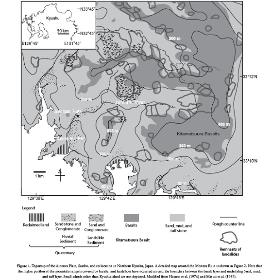
The Ainoura plain is one of the region’s small plains; several ruins have been excavated on this plain, indicating that people have been living on the Ainoura plain for at least 6 ka. The monzen ruins represent one such site. The Nagasaki prefectural board of Education excavated the ruins and published a report (2006); this paper is partly based on their excavation work. Their results were used to reveal the plain’s geomorphic history, including being struck by many rock avalanches. Figure 1
Geological data
The complicated shoreline of north-western Kyushu, Japan, has resulted from active subduction (Shimoyama et al., 1999) combined with erosion. This area lacks flatlands, but there are occasional wide river valleys; the Ainoura plain in western Sasebo, in which Monzen ruins are located, is one of these. Figure 1 gives a geological map of the Ainoura plain and vicinity. The most widespread stratigraphic units in the region are the Sasebo group and the Ainoura group consisting of Paleogene sand and mud (Matui et al., 1989). These groups lie beneath the 6-9 Ma -Kitamatsuura Basalt- (which includes basalt and andesite; Kaneoka and Aramaki, 1971; Matsui and Uto, 1998). Basalt and andesite cover mountain tops and the structure is unstable. Erosion of fragile sand and mud layers causes landslides; accordingly, this type of landslide has been named a Hokusho-type landslide by Noda (1957) and a detailed landslide map was prepared by Hatano et al., (1974a,b).
The Ainoura plain is an alluvial plain on the Ainoura River; the Hino River is a tributary of the Ainoura River and these two rivers converge near Ainoura Bay. Several ruins are present on the Ainoura plain (Figure 2).

The non-abraded items and existence of the rice phytolith suggested that people were living on the plain. However, these ruins are characterised by having been built on an alluvial plain which has experienced several destructive avalanches. The chronology of Japanese history, especially concerning when the Yayoi era began, is an active area of research, currently lacking consensus (Ozuka, 2000; Onishi, 2005; Yamamoto, 2007: Nakahashi and Iizuka, 2008). This research has been based on the conservative view that sets the start of Yayoi era around 2,300 years ago (Ozuka, 2000).
The paleoshoreline’s approximate position was determined by using drill data: Holocene deposits including marine shells and others which were continental. The location of the paleoshoreline was estimated from the intersection of the lowest marine deposits with the current terrain. The Holocene marine layer’s maximum extension represents the paleoshoreline during the Holocene climatic optimum (4000BC), when the sea level was at its highest. Shell fossils were collected from the bank of the Hino River (Figure 2). The plain’s depositional history was investigated by plotting sediment layers’ elevation changes. The ages of layers determined by NPBE (2008) was used mainly by means of seriation of potteries. When cultural objects were not found, 14C from fallen trees and tephra derived from the Sakurajia volcano was also used. Referring tephra helped to solve the problem of secondary deposition in some players. The elevations were adjusted by applying the modern gradient of the Ainoura River near the ruins, measured as 3.89/1,000 using an auto level. Accordingly, 38.9 cm would be added to the elevation of a sediment layer 100 m downwards from the centre of the ruins along the paleoriver channel, for example.
Results

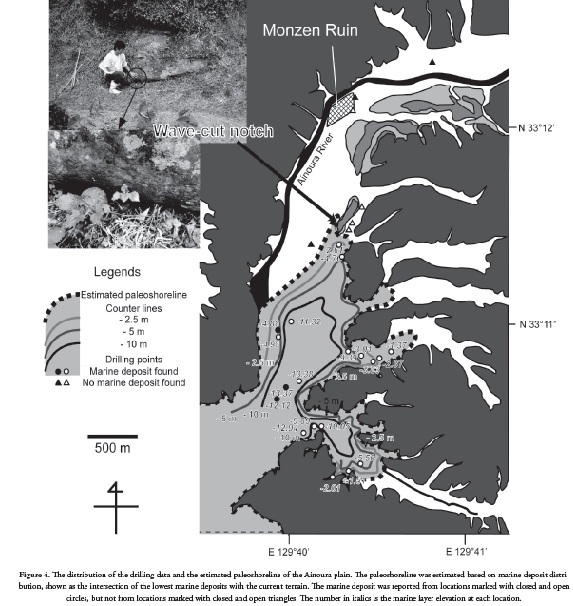
The 4,000 BC paleoshoreline was estimated (Figure 4) Beside the drill data, a wave-cut notch found on a hillside was considered as evidence of the paleoshoreline. Figure 4 shows that the Monzen ruins were about 1 km away from the shoreline; the shoreline at the Hino River was about 1 km away from the current shoreline. (Figure 5) shows how mud, sand and conglomerate layers developed on the plain.

Discussion
The Ainoura plain’s Paleogene unit consists of sand and mud layers having nearly horizontal stratification, covered by Kitamatsuura basalts. Landslides easily occur in such an area when underground water pressure rises. Noda (1957) reported that the area has experienced many such landslides. Comparing the cross-sections of the Hino and Ainoura rivers (Figure 3) revealed differences in their depositional histories. Considering the shell fossils from the Hino River, it was inferred that the Hino plain was originally an intertidal flat dominated by marginal marine sedimentation that subsequently became damp, subaerially exposed ground. By contrast, basaltic gravels from the Ainoura plain must have either been derived from landslides near the ruins, or carried from farther upstream. Since there is no evidence of landslides near the ruins (Figure 1), it was assumed that the basaltic gravels of the Monzen ruins were carried by the Ainoura River; fluvial influence is thus more pronounced than marine influence on the Ainoura plain.
A geological cross-section of the Ainoura Plain (Figure 3) revealed that the Monzen ruins were located near the sudden reduction in the gradient, and where the flood layer is thick. This suggested that such location was where the river’s flow rate suddenly drops and sedimentation occurs. These gravels did not begin to be deposited until 1,000 BC (Figure 5) at the location of the Monzen ruins. Gravel became successively deposited over the conglomerate layers after that, leading to the rising of the riverbed. Such trend was dissimilar to that of mud and sand layers (Figure 5B). Mud and sand layers most likely responded to changes in river water level which was influenced by changes in sea level. Yokoyama et al., 1999) reported sea level change in Tsumizu, western Kyushu, 50 km south-east of the Ainoura plain. The sea level change there was characterised by a sudden rise in sea level around 5,000 to 3,000 BC and a subsequent gradual fall, similar to the sand-mud deposition pattern on the Ainoura plain. Since the geomorphic history of western Kyushu is complicated (Yokoyama et al., 1996; Shomoyama et al., 1999), one cannot be certain whether the Ainoura plain experienced the same change in sea level as at Tsumizu, but it is possible that changes in Ainoura plain elevation record/reflect changes in sea level in western Kyushu.
(Figure 4) shows that the paleoshoreline was located about 1-2 km seaward from the Monzen ruins. After the Holocene climatic optimum, the shoreline has been gradually prograding due to sedimentation; however, the cross-section (Figure 3) showing locations between the paleoshoreline and the end of flood deposition is quite close. It was thus concluded that progradation did not alter the shoreline much, at least until the 17th century, when the Japanese began to reclaim the land (Nagata 1994). It can thus be expected that the deposition which happened at the location of the Monzen ruins described above probably also happened in the region between the Monzen ruins and the estimated paleoshoreline, accounting for almost half of the Ainoura Plain.
Conclusions
This research was focused on the geomorphic history of the Ainoura plain based on the Monzen ruins. Most of the strata of the Ainoura plain consists of basaltic conglomerate (flood deposit) and sand. Such basaltic gravels were derived from the Kitamatsuura basalts in the hinterland; such gravel represents landslide debris carried by floods to the plain to be deposited. The geographical cross-section revealed that the Monzen ruins were located at the sudden reduction in the river gradient, more flood sediments thus being deposited there. It was also found that mud and sand first filled in the trough, probably as part of the Jomon transgression caused by the Holocene climatic optimum. Later, conglomerate began to replace sand and mud layers by successive erosion and sedimentation, thus raising the riverbed. Around the final Jomon era (c.a. 500 BC), depositional elevation levels of gravel surpassed those of sand and mud. Considering the position of the paleoshoreline, such scenario is probably applicable to about half of the Ainoura plain.
Acknowledgments
Data regarding the Monzen ruins was kindly provided the Nagasaki Prefectural Government’s Excavation Office, Saseabo City Municipal Office and the Northern Nagasaki Prefecture’s Development and Promotion Bureau. The Fujinaga Geological and Construction Corporation provided the drilling core data. Professor Yoshiyuki Tanaka from the Social and Cultural Studies Graduate School, Kyushu University, suggested how to interpret wooden tombs. Dr. Ramues Gallois from the British Geological Survey, Dr. Patrick Druckenmiller and Dr. Rainer Newberry proofread the paper. Ms. Susana Salazar Jaramillo prepared the Spanish abstract. This research was financially assisted by emeritus professor Tatsuro Matsumoto Takachiho Scholarship, Kyushu University.
References
Aso, S. (1972): -Shimomotoyama Iwakage- Otsuka Kogei Sya,Tokyo, Japan.
Hatano, S., Okabe, F., and Watanabe, Y. (1974a): -Compilation of 1:50,000 geomorphological Classification map of landslide landforms in Hokusho District, Kyushu, Japan-. Notes of Cooperative Research for Disaster Prevention 32, 3-6.
Hatano, S., Okabe, F., Watanabe, Y., and Furukawa, T. (1974b): -A catalogue of large-scale landslide landforms formed in the Past in Hokusho (Kitamatsuura) District, North-western Kyushu, Japan-. Notes of Cooperative Research for Disaster Prevention 32, 7-23.
Kaneoka, I., and Arakami, S. (1971): -K-Ar age of Plagioclase from a Kita- Matsuura basalt and the reliability of plagioclase K-Ar age-. Journal of the geological society of Japan, 77. 6. 389-392.
Kumura, S. (1994): -Excavation of Shitanda Ruin Report- Sasebo City, Sasebo, Japan.
Matsui, K., and Utsu, K. (1998): -1:200.000 geological map -Karatsu--. Chishitsu News 521, 23-24.
Matsui, K., Suda, T. and Hiroshima, T. (1989): -1:200.000 geological map, Nagasaki Prefecture, NI-52-17-. Geological Survey of Japan , Tokyo, Japan.
Nagasaki Prefectural Board of Education, (2006): -Excavation Report of Buried Cultural Properties Involved in the Construction of Sasa-Sasebo National Route 497 VI: Monzen Ruin-. Research Report Cultural Property Research Office of Sasebo, Nagasaki Prefecture, 190.
Nagasaki Prefectural Board of Education, (2008): -Excavation Report of Buried Cultural Properties Involved in the Construction of Sasa- Sasebo National Route 497 V: Takebe C Ruin and Takebe D Ruin-. Research Report Cultural Property Research Office of Sasebo, Nagasaki Prefecture, 3.
Nagasaki Prefectural Board of Education, (2008): -Excavation Report of Buried Cultural Properties Involved in the Construction of Sasa- Sasebo National Route 497 VI: Monzen Ruin II-. Research Report Cultural Property Research Office of Sasebo, Nagasaki Prefecture, 4.
Nagata, K. (1994): -Evolution of land improvement districts in Japan-. Short report series on locally managed irrigation, 6.
Noda, M. (1957): -Karatsu Sasebo Ryo Tanden Nai no Jisuberi ni tuite (Report on landslides in the coal field of Karatsu and Sasebo)-. Kyushu Kozan Gakkai shi (Journal of Mining Engineering of Kyushu), 25, 11, 443-452.
Nakahashi, T.and Iizuka, M. (2008): -Anthropological study of the Transition from the Jomon to the Yayoi Periods in the Northern Kyushu using morphological and paleodemographical features (2)- Anthropological Science (Japanese Series), 116, 2, 131-143.
Onishi, S. (2005): -A review of the recent debate about the date of Yayoi period-. Anthropological Science (Japanese Series), 112, 2, 95-107.
Ozuka, S. (2000): -Desk-sized Chronological table of Japanese history augmented edition- Iwanami Books, Tokyo, Japan.
Shimoyama, S., Kinoshita, H., Miyahara, M., tanaka, Y., Ichihara, T. and Takemura, K. (1999): -Mode of vertical crustal movements during the Late Quaternary in Kyushu, Japan, deduced from heights of ancient shorelines-. Tectophysics, 302, 1-2, 9-22.
Yamamoto, N. (2007): -Archaeology integrates the humanities and science- Takashi shoiun, Tokyo, Japan.
Yokoyama, Y., Nakada, M., Maeda, Y., Nagaoka, S., Okuno, J., Matsumoto, E., Sato, H. and Matsushima, Y. (1996): -Holocene sea-level change and hydro-isostasy along the west coast of Kyushu, Japan-. Palaeogeography, Palaeoclimatology, Palaeoecology, 123, 29-47.
How to Cite
APA
ACM
ACS
ABNT
Chicago
Harvard
IEEE
MLA
Turabian
Vancouver
Download Citation
Article abstract page views
Downloads
License
Earth Sciences Research Journal holds a Creative Commons Attribution license.
You are free to:
Share — copy and redistribute the material in any medium or format
Adapt — remix, transform, and build upon the material for any purpose, even commercially.
The licensor cannot revoke these freedoms as long as you follow the license terms.


