Publicado
Revisión de métodos de sensores remotos para la detección y evaluación de la severidad de incendios forestales
Review of Remote Sensing Methods for the Detection and Evaluation of the Severity of Forest Fires
DOI:
https://doi.org/10.15446/ga.v23n2.93682Palabras clave:
Fuego, índices espectrales, imágenes satelitales, regeneración natural, reflectancia (es)Fire, spectral indices, satellite images, natural regeneration, reflectance (en)
Descargas
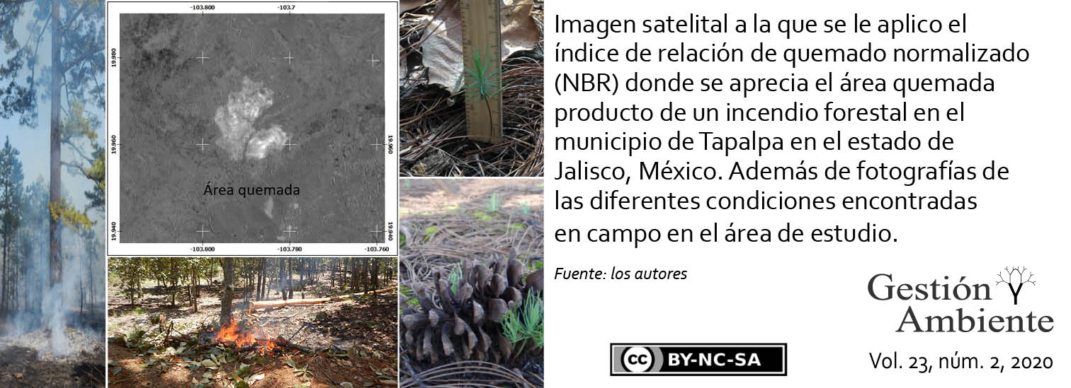
Los efectos que tienen los incendios en los ecosistemas forestales son variables, dependiendo de diversos factores entre los cuales se encuentra la severidad del fuego. Lo cual, a su vez, repercute en su recuperación. Sin embargo, evaluar áreas afectadas por fuego directamente en campo implica alta inversión de recursos que, junto con el tiempo, son generalmente limitados. No obstante, para la planeación de las estrategias de manejo y de restauración es necesario tener conocimiento del impacto del fuego. Para esto, los sensores remotos son una herramienta práctica para la evaluación de grandes áreas, o áreas inaccesibles, impactadas por incendios forestales. Cuyo uso va en aumento, siguiendo diferentes perspectivas de evaluación, como son el espectro infrarrojo, la detección de vegetación, ubicación de cenizas, etc. Por lo que para saber cuál es la mejor alternativa en el estudio de incendios forestales, es necesario conocer toda la gama de posibilidades y de esta manera poder elegir la más conveniente. Debido a esto, en este trabajo se hace una revisión de diferentes propuestas de evaluación de áreas impactadas por incendios forestales a través de sensores remotos. Las cuales se definen, principalmente, en una serie de índices espectrales, con base a los cuales, directa o indirectamente, se pretende no solo ubicar y dimensionar los incendios forestales, sino, en algunos casos, determinar el nivel de severidad. De esta forma, en este documento se agrupan las principales propuestas, con base a sus objetivos de detección de áreas impactadas: vegetación, suelo, agua, área quemada y radar.
The effects that fires have on forest ecosystems are variable, depending on various factors, including the severity of the fire. Which, in turn, affects your recovery. However, evaluating fire-affected areas directly in the field involves high investment of resources that, along with time, are generally limited. However, for the planning of management and restoration strategies it is necessary to have knowledge of the impact of fire. For this, remote sensors are a practical tool for the evaluation of large areas, or inaccessible areas, impacted by forest fires. Whose use is increasing, following different evaluation perspectives, such as the infrared spectrum, the detection of vegetation, ash location, etc. So to know which is the best alternative in the study of forest fires, it is necessary to know the full range of possibilities and thus be able to choose the most convenient one. Due to this, in this work a review is made of different evaluation proposals of areas impacted by forest fires through remote sensors. Which are mainly defined in a series of spectral indices, based on which, directly or indirectly, it is intended not only to locate and size forest fires, but, in some cases, to determine the level of severity. Thus, in this document the main proposals are grouped, based on their objectives for detecting impacted areas: vegetation, soil, water, burned area and radar.
Referencias
Baret, F., Guyot, G., 1991. Potentials and limits of vegetation indices for LAI and APAR assessment. Remote Sens. Environ. 35, 161-173. DOI: 10.1016/0034-4257(91)90009-U
Bastarrika, A., Chuvieco, E., Martín, M., 2011a. Automatic burned land mapping from MODIS time series images: Assessment in mediterranean ecosystems. IEEE Trans. Geosci. Remote Sens. 49, 3401-3413. DOI: 10.1109/TGRS.2011.2128327
Bastarrika, A., Chuvieco, E., Martín, M., 2011b. Mapping burned areas from Landsat TM/ETM+ data with a two-phase algorithm: Balancing omission and commission errors. Remote Sens. Environ. 115, 1003-1012. DOI: 10.1016/j.rse.2010.12.005
Bisson, M., Fornaciai, A., Coli, A., Mazzarini, F., Pareschi, M., 2008. The Vegetation Resilience After Fire (VRAF) index: Development, implementation and an illustration from central Italy. Int. J. Appl. Earth Obs. Geoinf. 10, 312-329. DOI: 10.1016/j.jag.2007.12.003
Cardil, A., Mola-Yudego, B., Blázquez-Casado, Á., González-Olabarria, J., 2019. Fire and burn severity assessment: Calibration of Relative Differenced Normalized Burn Ratio (RdNBR) with field data. J. Environ. Manag. 235, 342-349. DOI: 10.1016/j.jenvman.2019.01.077
Chen, Y., Lara, M., Hu, F., 2020. A robust visible near-infrared index for fire severity mapping in Arctic tundra ecosystems. ISPRS J. Photogramm. Remote Sens. 159, 101-113. DOI: 10.1016/j.isprsjprs.2019.11.012
De Santis, A., Chuvieco, E., 2009. GeoCBI: A modified version of the Composite Burn Index for the initial assessment of the short-term burn severity from remotely sensed data. Remote Sens. Environ. 113, 554-562. DOI: 10.1016/j.rse.2008.10.011
Domaç, A., Zeydanli, U., Yeşilnacar, E., Süzen, M., 2004. Integration and usage of indices, feature components and topography in vegetation classification for regional biodiversity assessment. En: 20th Congreso de ISPRS. Estambul. pp. 204-208.
Edwards, A., Maier, S., Hutley, L., Williams, R., Russell-Smith, J., 2013. Spectral analysis of fire severity in north Australian tropical savannas. Remote Sens. Environ. 136, 56-65. DOI: 10.1016/j.rse.2013.04.013
Fernandes, M., Aguiar, F., Martins, M., Rico, N., Ferreira, M., Correia, A., 2020. Carbon stock estimations in a mediterranean riparian forest: A case study combining field data and UAV imagery. Forests 11, 376-397. DOI: 10.3390/f11040376
Fornacca, D., Guopeng, R., Xiao, W., 2018. Evaluating the best spectral indices for the detection of burn scars at several post-fire dates in a Mountainous region of Northwest Yunnan, China. Remote Sens. 10, 1196. DOI: 10.3390/rs10081196
Fernández-Manso, A., Fernández-Manso, O., Quintano, C., 2016. SENTINEL-2A red-edge spectral indices suitability for discriminatingburn severity. Int. J. Appl. Earth Obs. Geoinf. 50, 170-175. DOI: 10.1016/j.jag.2016.03.005
García M., Pérez-Cabello, E., 2015. Análisis de la regeneración vegetal mediante imágenes Landsat-8 y el producto MCD15A2 de MODIS: el caso del incendio de O Pindo. En: de la Riva, J., Ibarra, P., Montorio, R., Rodrigues, M. (Eds.), Análisis espacial y representación geográfica: innovación y aplicación. Asociación de Geógrafos Españoles; Universidad de Zaragoza, Zaragoza, España. pp. 621-630.
Gao, B., 1996. NDWI - A normalized difference water index for remote sensing of vegetation liquid water from space. Remote Sens. Environ. 58, 257-266. DOI: 10.1117/12.210877
Gitas, I., Mitri, G., Veraverbeke, S., Polychronaki, A., 2012. Advances in remote sensing of post-fire vegetation recovery monitoring-a review. En: Moisan, T., Sathyendranath, S., Bouman, H. (Eds.), Remote sensing of biomass-principles and applications. Intech. DOI: 10.5772/20571
González, M., Schwendenmann, L., Jiméne, J., Schulz, R., 2008. Forest structure and woody plant species composition along a fire chronosequence in mixed pine-oak forest in the Sierra Madre Oriental, Northeast Mexico. For. Ecol. Manag. 256, 161-167. DOI: 10.1016/j.foreco.2008.04.021
Harris, S., Veraverbeke, S., Hook, S., 2011. Evaluating spectral indices for assessing fire severity in Chaparral ecosystems (Southern California) using MODIS/ASTER (MASTER) airborne simulator data. Remote Sens. 3, 2403-2419. DOI: 10.3390/rs3112403
Herawati, H., Gonzales-Olabarria, J., Wijaya, A., Martius, C., Purnomo, H., Andriani, R., 2015. Tools for assessing the impacts of climate variability and change on wildfire regimes in forests. Forests 6, 1476-1499. DOI: 10.3390/f6051476
Hudak, A., Morgan, P., Bobbitt, M., Smith, A., Lewis, S., Lentile, L., Robichaud, P., Clark, J., McKinley, R., 2007. The relationship of multispectral satellite imagery to immediate fire effects. Fire Ecol. 3(1), 64-90. DOI: 10.4996/fireecology.0301064
Huete, A., Didan, K., Miura, T., Rodriguez, E., Gao, X., Ferreira L., 2002. Overview of the radiometric and biophysical performance of the MODIS vegetation índices. Remote Sens. Environ. 83, 195-213. DOI: 10.1016/S0034-4257(02)00096-2
Huete, A.,1988. A soil-adjusted vegetation index (SAVI). Remote Sens. Environ. 25, 295-309. DOI: 10.1016/0034-4257(88)90106-X
Ichoku, C., Kahn, R., Chin, M., 2012. Satellite contributions to the quantitative characterization of biomass burning for climate modeling. Atmos. Res. 111, 1-28. DOI: 10.1016/j.atmosres.2012.03.007
Ireland, G., Petropoulos, G., 2015. Exploring the relationships between post-fire vegetation regeneration dynamics, topography and burn severity: A case study from the Montane Cordillera Ecozones of Western Canada. Appl. Geogr. 56, 232-248. DOI: 10.1016/j.apgeog.2014.11.016
Kasischke, E., Turetsky, M., Ottmar, R., French, N., Hoy, E., Kane, E., 2008. Evaluation of the composite burn index for assessing fire severity in Alaskan black spruce forests. Int. J. Wildland Fire 17, 515-526. DOI: 10.1071/WF08002
Kauth, R., Thomas, G., 1976. The tasselled Cap-A descripción gráfica del desarrollo espectral-temporal de cultivos agrícolas según lo visto por Landsat. LARS Symposia Paper 159. Purdue University. West Lafayette, IN.
Key, C., Benson, N., 2006. Landscape Assessment (LA) sampling and analysis methods. En: Lutes, D., Keane, R., Caratti, J., Key, C., Benson, N., Sutherland, S., Gangi, L. (Eds.), FIREMON: Fire effects monitoring and inventory system. Gen. Tech. Rep. RMRSGTR- 164-CD. USDA Forest Service, Rocky Mountain Research Station, Fort Collins, CO. pp. LA1- LA 55.
López G., A., 2020. Estudio de la severidad del incendio de 2012 y regeneración de la vegetación del Bosque La Primavera, México, mediante imágenes LANDSAT 7. Rev. Cartogr. 101, 35-50. DOI: 10.35424/rcarto.i101.420
Li, R., Kaufman, Y., Hao, W., Salmon, J., Gao, B., 2004. A technique for tecting burn scars using MODIS data. IEEE Trans. Geosci. Remote Sens. 42, 1300-1308. DOI: 10.1109/TGRS.2004.826801
Lu, B., He, Y., Tong, A., 2016. Evaluation of spectral indices for estimating burn severity in semiarid grasslands. Int. J. Wildland Fire 25, 147-157. DOI: 10.1071/WF15098
Mallinis, G., Mitsopoulos, I., Chrysafi, I., 2018. Evaluating and comparing Sentinel 2A and Landsat-8 Operational Land Imager (OLI) spectral indices for estimating fire severity in a Mediterranean pine ecosystem of Greece. GISci. Remote Sens. 55, 11-18. DOI: 10.1080/15481603.2017.1354803
Mallinis, G., Koutsias, N., 2012. Comparing ten classification methods for burned area mapping in a Mediterranean environment using Landsat TM satellite data. Int. J. Remote Sens. 33, 4408-4433. DOI: 10.1080/01431161.2011.648284
Martínez-Barbáchano, R., Solís-Miranda, G., 2018. Caracterización espectral y detección de flecha seca en palma africana en Puntarenas, Costa Rica. Rev. Geog. Amer. Central 61, 349-377. DOI: 10.15359/rgac.61-2.13
McCarley, T., Kolden, C., Vaillant, N., Hudak, A., Smith, A., Wing, B., Kellogg, B., Kreitler, J., 2017. Multi-temporal LiDAR and Landsat quantification of fire-induced changes to forest structure. Remote Sens. Environ. 191, 419-432. DOI: 10.1016/j.rse.2016.12.022
Miller, J., Knapp, E., Key, C., Skinner, C., Isbell, C., Creasy, R., Sherlock, J., 2009. Calibration and validation of the relative differenced Normalized Burn Ratio (RdNBR) to three measures of fire severity in the Sierra Nevada and Klamath Mountains, California, USA. Remote Sens. Environ. 113, 645-656. DOI: 10.1016/j.rse.2008.11.009
Oliva, P., Martín, P., Chuvieco, E., 2011. Burned area mapping with MERIS post-fire image. Int. J. Remote Sens. 32, 4175-4201. DOI: 10.1080/01431161.2010.489062
Parks, S., Dillon, G., Miller, C., 2014. A new metric for quantifying burn severity: The relativized burn ratio. Remote Sens. 6, 1827-1844. DOI: 10.3390/rs6031827
Quintano, C., Fernández-Manso, A., Stein, A., Bijker, W., 2011. Estimation of area burned by forest fires in Mediterranean countries: A remote sensing data mining perspective. Forest Ecol. Manag. 262, 1597-1607. DOI: 10.1016/j.foreco.2011.07.010
Riaño, D., Chuvieco, E., Ustina, S., Zomer, R., Dennison, P., Roberts, D., Salas, J., 2002. Assessment of vegetation regeneration after fire through multitemporal analysis of AVIRIS images in the Santa Monica Mountains. Remote Sens. Environ. 79, 60-71. DOI: 10.1016/S0034-4257(01)00239-5
Rondeaux, G., Steven, M., Baret, F., 1996. Optimization of soil-adjusted vegetation indices. Remote Sens. Environ. 55, 95-107. DOI: 10.1016/0034-4257(95)00186-7
Soverel, N., Coops, N., Perrakis, D., Daniels, L., Gergel, S., 2011. The transferability of a dNBR-derived model to predict burn severity across 10 wildland fires in western Canada. Int. J. Wildland Fire 20, 518-531. DOI: 10.1071/WF10081
Smith, A., Drake, N., Wooster, M., Hudak, A., Holden, Z., Gibbons, C., 2007. Production of Landsat ETM + reference imagery of burned areas within Southern African savannahs: comparison of methods and application to MODIS. Int. J. Remote Sens. 28, 2753-2775. DOI: 10.1080/01431160600954704
Tanase, M., de la Riva, J., Pérez-Cabello, F., 2011a. Estimating burn severity at the regional level using optically based indices. Can. J. For. Res. 41, 863-872. DOI: 10.1139/x11-011
Tanase, M., de la Riva, J., Santoro, M., Pérez-Cabello, F., Kasischke, E., 2011b. Sensitivity of SAR data to post-fire forest regrowth in Mediterranean and boreal forests. Remote Sens. Environ. 115, 2075-2085. DOI: 10.1016/j.rse.2011.04.009
Tanase, M., Kennedy, R., Aponte, C., 2015a. Radar burn ratio for fire severity estimation at canopy level: An example for temperate forests. Remote Sens. Environ. 170, 14-31. DOI: 10.1016/j.rse.2015.08.025
Tanase, M., Kennedy, R., Aponte C., 2015b. Fire severity estimation from space: a comparison of active and passive sensors and their synergy for different forest types. Int. J. Wildland Fire 24, 1062-1075. DOI: 10.1071/WF15059
Tran, B., Tanase, M., Bemmett, L., Aponte, C., 2018. Evaluation of spectral indices for assessing fire severity in Australian temperate forests. Remote Sens. 10, 1680. DOI: 10.3390/rs10111680
Tran, N., Tanase, M., Bennett, L., Aponte C., 2019. Fire-severity classification across temperate Australian forests: random forests versus spectral index thresholding. Proc. SPIE 11149. Remote Sens. Agric. Ecosyst. Hydrol. 21, 111490U. DOI: 10.1117/12.2535616
Urbanski, S., Salmon, J., Nordgren, B., Hao, W., 2009. A MODIS direct broadcast algorithm for mapping wildfire burned area in the western United States. Remote Sens. Environ. 113, 2511-2526. DOI: 10.1016/j.rse.2009.07.007
Veraverbeke, S., Lhermitte, S., Verstraeten, W., Goossens, R., 2010. The temporal dimension of differenced Normalized Burn Ratio (dNBR) fire/burn severity studies: The case of the large 2007 Peloponnese wildfires in Greece. Remote Sens. Environ. 114, 2548-2563. DOI: 10.1016/j.rse.2010.05.029
Yaloveha, V., Hlavcheva, D., Podorozhniak, A., 2019. Usage of convolutional neural network for multispectral image processing applied to the problem of detecting fire hazardous forest áreas. Adv. Infor. Syst. 3, 116-120. DOI: 10.20998/2522-9052.2019.1.19
Cómo citar
APA
ACM
ACS
ABNT
Chicago
Harvard
IEEE
MLA
Turabian
Vancouver
Descargar cita
CrossRef Cited-by
1. M. H. Ysla Huaman, E. Romero Garcia, M. O. Bacilio Hilario, J. V. Cornejo Tueros. (2024). Trends in Environmental Sustainability and Green Energy. Springer Proceedings in Earth and Environmental Sciences. , p.83. https://doi.org/10.1007/978-3-031-52330-4_7.
2. José Germán Flores Garnica, Gabriela Orozco Gutiérrez, Gabriela Ramírez Ojeda. (2025). Determinación de áreas de protección prioritaria basada en la densidad Kernel de incendios forestales. Revista Mexicana de Ciencias Forestales, 16(90), p.4. https://doi.org/10.29298/rmcf.v16i90.1523.
3. José M. Zúñiga-Vásquez, José Villanueva-Díaz, Julián Cerano-Paredes, Gerónimo Quiñonez-Barraza. (2022). Effect of Fire Severity on the Species Diversity and Structure of a Temperate Forest in Northern Mexico. Forests, 13(7), p.1121. https://doi.org/10.3390/f13071121.
4. Christian Chura Rayo, Jonathan Joseph Almirón Baca, Camila Aguilar Ccuno, Silvia Tapia Medrano, Juan Carlos Licona Paniagua, Luis Alvarez Soto, Danny Pamela Tupayachy Quispe. (2025). Research and Innovation in Renewable Energy and Environment. Earth and Environmental Sciences Library. , p.235. https://doi.org/10.1007/978-3-031-61956-4_19.
5. A Hernández-Ramos, JR Valdez-Lazalde, HM De Los Santos-Posadas, VJ Reyes-Hernández, PM López-Serrano, A Cano-Pineda, H Flores-Magdaleno. (2025). Classification of xeric scrub forest species using machine learning and optical and LiDAR drone data capture. iForest - Biogeosciences and Forestry, 18(6), p.357. https://doi.org/10.3832/ifor4720-018.
Dimensions
PlumX
Visitas a la página del resumen del artículo
Descargas
Licencia

Esta obra está bajo una licencia internacional Creative Commons Atribución-NoComercial-CompartirIgual 4.0.
Los artículos que sean publicados en la revista Gestión y Ambiente, también serán publicados en el sitio web http://www.revistas.unal.edu.co/index.php/gestion/index y en formatos electrónicos como PDF, HTML, XML, entre otros. Además, en diferentes redes sociales de difusión del conocimiento. Gestión y Ambiente adopta directrices de ética por Committee on Publication Ethics (COPE) sobre buenas prácticas de conducta (evitar conductas como plagio, falsificación, autoría ficticia, entre otros), describe conflictos de interés o en competencia, contribuciones de autoría y fuentes de financiación. Todo lo publicado se considerará propiedad de la revista Gestión y Ambiente, pero pueden usarse bajo la licencia Creative Commons “Reconocimiento-No Comercial-Compartir Igual International (BY-NC-SA) 4.0”