Publicado
Preliminary Model of Potential Areas for Restoration for the Inter-Andean Valley of Cauca River (Colombia, South America) Based on Habitat Suitability Models
Modelo preliminar de áreas potenciales de restauración para el valle interandino del río Cauca (Colombia, Suramérica) basado en modelos de idoneidad de hábitat
DOI:
https://doi.org/10.15446/abc.v29n2.103070Palabras clave:
Deciduous forest, ecological niche, landscape management, modeling, sustainable development (en)Bosque deciduo, desarrollo sostenible, gestión del paisaje, nicho ecológico, modelación (es)
Descargas
Archivos adicionales
Tropical dry forests (TDF) are highly susceptible to land degradation. The inter-Andean Valley of the Cauca River (IVCR) has the most fragmented Colombian dry forests, and their restoration is essential. Here, potential areas for restoration were identified using a habitat suitability modeling (HSM) approach. TDF vascular plants and bioclimatic predictors were used. Species were selected based on threatened status, endemism, and priority level for conservation. Two sets of predictors were chosen using Variance Inflation Factor (VIF) and Principal Component Analysis (PCA). Then, with a maximum entropy algorithm, PCA and VIF models were projected for the selected species. These models were evaluated via true skill statistics (TSS) and area under the curve (AUC) statistical metrics. Models with good performance (TSS, AUC, standard deviation, variance) were ensembled, and a preliminary model where areas with suitable bioclimatic conditions for the selected species were generated. Results show that nearly 45 % of the IVCR has suitable conditions for the selected species. Although potential conflicts may arise in areas under permanent or semipermanent crops which represent more than 80 % of the IVCR, cropland mosaics, and natural and seminatural land covers might provide alternative solutions to reduce the land-use conflict. The potential areas for restoration identified in this study may provide a comprehensive framework for environmental impact and regional risk assessments related to the current land use and land cover change dynamics. Also, they may provide relevant information for designing landscape restoration programs as an adaptive strategy toward climate change.
Los bosques secos tropicales (BsT) son ecosistemas vulnerables a la degradación. En el Valle Interandino del Río Cauca (VIRC), los BsT están muy fragmentados y necesitan restauración. Para identificar áreas potenciales de restauración se aplicó modelación de idoneidad del hábitat (HSM) utilizando plantas vasculares del BsT y predictores bioclimáticos. Se escogieron especies según su amenaza, endemismo y prioridad de conservación, y las variables según el factor de inflación de varianza (FIV) y el análisis de componentes principales (ACP). Usando un algoritmo de máxima entropía y predictores ACP y FIV seleccionados, se identificaron áreas bioclimáticas idóneas para las especies seleccionadas. Estos modelos se evaluaron a través de las métricas True skill statistic (TSS) y del área bajo la curva (AUC). Modelos con buen desempeño (TSS, AUC, desviación estándar, varianza) se ensamblaron en un modelo preliminar donde se observó que cerca del 45 % del VIRC tiene condiciones adecuadas. Aunque pueden darse conflictos potenciales para la restauración en áreas con cultivos permanentes o semipermanentes (80 % del VIRC), los mosaicos de tierras de cultivo y las coberturas naturales y seminaturales ofrecen soluciones alternativas para reducirlos. Las áreas potenciales para la restauración identificadas en este estudio pueden proporcionar un marco integral para estudios del impacto ambiental y de riesgo regional relacionadas con el uso actual de la tierra y las dinámicas de cambios de uso. Asimismo, esta investigación aporta elementos importantes para el diseño de programas de restauración del paisaje como estrategia de adaptación al cambio climático.
Recibido: 11 de agosto de 2022; Revisión recibida: 11 de julio de 2023; Aceptado: 15 de agosto de 2023
ABSTRACT
Tropical dry forests (TDF) are highly susceptible to land degradation. The inter-Andean Valley of the Cauca River (IVCR) has the most fragmented Colombian dry forests, and their restoration is essential. Here, potential areas for restoration were identified using a habitat suitability modeling (HSM) approach. TDF vascular plants and bioclimatic predictors were used. Species were selected based on threatened status, endemism, and priority level for conservation. Two sets of predictors were chosen using Variance Inflation Factor (VIF) and Principal Component Analysis (PCA). Then, with a maximum entropy algorithm, PCA and VIF models were projected for the selected species. These models were evaluated via true skill statistics (TSS) and area under the curve (AUC) statistical metrics. Models with good performance (TSS, AUC, standard deviation, variance) were ensembled, and a preliminary model where areas with suitable bioclimatic conditions for the selected species were generated. Results show that nearly 45% of the IVCR has suitable conditions for the selected species. Although potential conflicts may arise in areas under permanent or semipermanent crops which represent more than 80% of the IVCR, cropland mosaics, and natural and seminatural land covers might provide alternative solutions to reduce the land-use conflict. The potential areas for restoration identified in this study may provide a comprehensive framework for environmental impact and regional risk assessments related to the current land use and land cover change dynamics. Also, they may provide relevant information for designing landscape restoration programs as an adaptive strategy toward climate change.
Keywords
Deciduous forest, ecological niche, landscape management, modeling, sustainable development.RESUMEN
Los bosques secos tropicales (BsT) son ecosistemas vulnerables a la degradación. En el Valle Interandino del Río Cauca (VIRC), los BsT están muy fragmentados y necesitan restauración. Para identificar áreas potenciales de restauración se aplicó modelación de idoneidad del hábitat (HSM) utilizando plantas vasculares del BsT y predictores bioclimáticos. Se escogieron especies según su amenaza, endemismo y prioridad de conservación, y las variables según el factor de inflación de varianza (FIV) y el análisis de componentes principales (ACP). Usando un algoritmo de máxima entropía y predictores ACP y FIV seleccionados, se identificaron áreas bioclimáticas idóneas para las especies seleccionadas. Estos modelos se evaluaron a través de las métricas True skill statistic (TSS) y del área bajo la curva (AUC). Modelos con buen desempeño (TSS, AUC, desviación estándar, varianza) se ensamblaron en un modelo preliminar donde se observó que cerca del 45% del VIRC tiene condiciones adecuadas. Aunque pueden darse conflictos potenciales para la restauración en áreas con cultivos permanentes o semipermanentes (80% del VIRC), los mosaicos de tierras de cultivo y las coberturas naturales y seminaturales ofrecen soluciones alternativas para reducirlos. Las áreas potenciales para la restauración identificadas en este estudio pueden proporcionar un marco integral para estudios del impacto ambiental y de riesgo regional relacionadas con el uso actual de la tierra y las dinámicas de cambios de uso. Asimismo, esta investigación aporta elementos importantes para el diseño de programas de restauración del paisaje como estrategia de adaptación al cambio climático.
Palabras clave
Bosque deciduo, desarrollo sostenible, gestión del paisaje, nicho ecológico, modelación.INTRODUCTION
Land-use/land-cover change (LULCC) is considered a major driver of biodiversity loss. As a result of the intensification of human activities, land degradation has become one of the main environmental issues that society must face (Intergovernmental Science-Policy Platform on Biodiversity and Ecosystem Services [IPBES, 2018]). Nkonya et al., 2015; LULCC modifies the landscape structure reducing its species richness and abundance, which leads to erosion, fertility loss, and salinization (IPBES, 2018). With altered ecological dynamics, ecosystem services such as biodiversity maintenance, carbon storage, regulation of water flow, and local and regional climate patterns cannot be provided or regulated by the changed landscape conditions (Schild et al., 2018; van der Plas et al., 2019).
Among the most affected ecosystems by LULCC are those found in the drylands, which are characterized mainly by precipitation deficit and variability (Miles et al., 2006; García et al., 2014; Schild et al., 2018; Siyum, 2020). Tropical dry forests (TDF) or seasonally dry tropical forests (SDTF) are commonly found within climatic zones with semi-arid and sub-humid conditions (Holdridge, 1967). They are distinguished by moist deficit, seasonal precipitation pattern, and temperatures ranging between 17 and 24 °C (Miles et al., 2006).
By the beginning of the 20th century, 50 % of the world's dry forest area was already lost due to deforestation leaving an estimated global remanent of 1´048.700 km2 at the start of the 21st century (Miles et al., 2006). However, subsequent studies have estimated an area of 4´369.695 km2 (Pando et al., 2021). This is of concern because estimating the extent of biomes such as dry forests always implies further considerations such as the boundaries used to estimate the area as well as the characteristics that reflect its nature, and with this, the data needed to calibrate and validate the models (Pando et al., 2021).
As semi-arid environments are prone to desertification processes due to the synergies created between intensive anthropic land uses and their characteristic drought periods (IPBES, 2018), ecological restoration may become the most relevant adaptative strategy to face climate change (Reed et al., 2016). Nevertheless, defining areas to be restored is challenging for decision-makers and stakeholders involved in land-use planning and environmental management (Bustamente et al., 2019; Török and Helm, 2017).
Restoration plans have focused traditionally on site-level recovery (Török and Helm, 2017) due to the challenges imposed by human-dominated landscapes (IPBES, 2018; Reed et al., 2016; van der Plas et al., 2019). From a land-use management perspective, restoring large extents is more appealing as is aligned with major international initiatives such as the Bonn Challenge or the Aichi Targets (Chazdon et al., 2017; Meli et al., 2019). But ensuring sustainable landscapes requires large-scale restoration efforts (Török and Helm, 2017). Although restoring large, degraded areas may prevent intensive land uses in the future, they will contribute to reducing carbon emissions while assisting in biodiversity conservation, agricultural production, and provision of ecosystem services (Chazdon et al., 2017; Meli et al., 2019).
Restoration planning usually requires a reference ecosystem that provides a baseline with the desired species composition and their habitat conditions (Török and Helm, 2017). Therefore, selecting potential areas for restoration should be based on a species' habitat requirements (Araujo et al., 2016).
Different approaches have been developed and used in conservation planning which include the use of algorithms to select and prioritize habitats that will become new protected areas or to complement the existing network. For example, in restoration initiatives, habitat suitability modeling (HSM) or species distribution modeling (SDM) has started to gain relevance (Miranda et al., 2019; Zellmer et al., 2019; Zhong et al., 2021), as they provide valuable information to support the decision-making process for conservation planning (Mestre et al., 2017).
Selection criteria for restoration areas often involve measuring habitat quality, among others. The habitat reflects the ecological value of a landscape for a given species in terms of its suitability (Araujo et al., 2016). In a landscape-restoration approach, an ecosystem of reference or a baseline of species composition to be restored will be ideal, to have an approximation of the desired habitat conditions (Török and Helm, 2017; Maiorano et al., 2019).
SDM is based on the correlation between a species' occurrence and the environmental conditions of the locality in which the species was observed (Jarnevich et al., 2015; Maiorano et al., 2019). Among SDM algorithms, the maximum entropy (MaxEnt) is one of the most widely used techniques due to its high performance when using presence-only data (Radosavljevic and Anderson, 2014) and its flexibility in terms of data requirements (García-Callejas and Araújo, 2016). Furthermore, when technical and human resources are a constraint for detailed ecological monitoring and assessments, SDM has the potential to assist in this issue.
In this research, the inter-Andean valley of the Cauca River (IVCR) is used as a study case. This region has lost most of its dry forest cover because of the intensified agricultural production that took place after the second half of the twentieth century (Arcila Cardona et al., 2012; García et al., 2014; Alvarado-Solano and Otero, 2017; Alvarado-Solano and Otero, 2015). The purpose of this research was to identify potential areas for restoration using a habitat suitability modeling approach for a set of vascular plants as a tool to assist in future landscape-restoration initiatives for the inter-Andean valley of the Cauca River (IVCR) in Colombia. Furthermore, we aimed to answer the following questions: (1) How many vascular plants have geographical distribution within the study area? (2) How do the bioclimatic variables predictors differ among the plant species? (3) Which bioclimatic variables are the most important in predicting suitable areas for the plant species within the IVCR? (4) What are the environmental conditions of the bioclimatically suitable areas?
MATERIALS AND METHODS
STUDY AREA
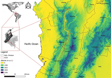
The inter-Andean valley of the Cauca River, with an approximate area of 10605 km2 is in the southwestern of the Colombian Andes, between the Western and Central Cordilleras (3°00'3.9902'' N--76°39'25.85'' W, 7°17'41.4902'' N--75°21'32.762'' E) (Fig. 1a). It has an average elevation of 969.65 m, a minimum of 195 m and a maximum of 1200 m, with the elevation decreasing from South to North (Fig. 1, NASA-JPL, 2013).
Temperature ranges from 15.3 °C to 32 °C (mean: 23.4 °C) indicating the highly variable regional climate which is strongly influenced by the precipitation regime (Table S1). The mean monthly and annual precipitation values are 158.85 mm and 1906 mm respectively, being May and October as the months with the highest rainfall and January and July the driest months (Table S1).
The study area encompasses five administrative departments, which are Antioquia (25 %), Caldas (9 %), Risaralda (5 %), Quindío (3 %), Valle del Cauca (48 %), and Cauca (10 %) (Fig. 1). Valle del Cauca is the most populated department, with 27 of its 42 municipalities located within the valley of the Cauca River (Santana and Vásquez, 2002). The population is characterized mainly by living in urban areas and concentrated in cities such as Cali, Palmira, Buga, Tuluá, and Cartago, located in the south of the study area (Corporación Autónoma Regional del Valle del Cauca [CVC], 2015), or concentrated in rural settlements (Santana and Vásquez, 2002). The projected population in the year 2020 for the southern portion of Valle del Cauca was 3,325,070 inhabitants, with 93 % being in the urban areas (CVC, 2015). The central and northern areas of Valle del Cauca have shown signs of a decrease in population growth, although they have a similar trend toward highly populated urban areas (CVC, 2015).
Figure 1: Delimitation of the Inter-Andean Valley of the Cauca River in Colombia.
1 As defined by IDEAM et al. (2018).
Table 1: Summary of land cover types where bioclimatic suitable areas for restoration were found for at least half (3 up to 5) of the species selected in this study.
SELECTION OF SPECIES
Building a plant-species database
As the current knowledge of plant species with distributional ranges within or including the study area is limited, an effort was made to fill that gap by building a vascular plant database after surveying the Colombian portal of biodiversity (S1). In summary, the steps followed were: (1) retrieving datasets for which vascular plants were reported in the study area; (2) data cleaning process in which only records reported at the species level, geographically referenced or with a full locality description were kept; (3) updating taxonomic nomenclature; and (4) eliminating duplicated records under the same scientific name and authorship.
Species selection
Species were selected based on the following criteria (Fig. 2): A) Conservation status or threat level: includes vascular plants threatened at the national level (Table S2) and the regional level (Table S2); B) Endemism: plant species found in the tropical dry forests (TDF) and identified as endemic at the national level (Table S2) 4); and, C) Level of prioritization: includes vascular plant species with priority for conservation at the national level (Table S2), TDF vascular species prioritized at the national level (Table S2); and TDF vascular plants with high priority for conservation at regional level (Table S2).
Once the selection criteria were applied, a subset of species was kept for further refining (Table S3), in which plant species included in two of the three criteria listed, were pre-selected for the subsequent modeling process (Table S4).
HABITAT SUITABILITY MODELING
Species occurrences
Occurrence records for the pre-selected species were retrieved from the Global Biodiversity Information Facility (Table S2), and a 30-occurrence threshold was applied to choose the species to be used in the modeling process (Table S4). This threshold was chosen because it has been proven to produce effective results when used to calibrate HSM models. (Kaky et al., 2020). Records with incomplete geographic coordinates, duplicates, and those falling in water bodies (lakes and oceans) were removed. Afterward, a 10-km radius spatial filtering was applied to each species occurrence dataset to reduce spatial autocorrelation and over-predictive performance (Table S4, Fig. S1) (Kramer-Schadt et al., 2013). All data cleaning and pre-processing were performed in QGIS V3.10.0 and R Studio V2021.9.1.372 (RStudio team, 2021).
Figure 2: Preselection of species for the modeling process based on categories A: status of threat, B: endemism, and C: level of Prioritization (Species pre-selected in D). Figures in brackets: number of species. SDTF: Seasonally dry tropical forests. 1VP Consv: vascular plants prioritized for conservation at the national level. 2SDTF sp: SDTF prioritized plant species for conservation at the national and regional levels.
Environmental predictors
Habitat suitability models are built using a species distribution modeling technique, which classifies an area in a landscape as highly suitable or less suitable for a species based on the species' occurrences -- predictors relationship (García-Callejas and Araújo, 2016). In this study, 19 bioclimatic variables were retrieved from WordClim with a 30 arc-second spatial resolution (Table S2) and then adjusted to the training area (Fig. S1).
A matrix of occurrences -- predictors' values was prepared for each species for a screening process using principal component analysis (PCA) and variance inflation factor (VIF) (Dormann et al., 2013; Fois et al., 2018; Neves et al., 2015; Poirazidis et al., 2019). These two techniques are among the most used for reducing model complexity and the bias generated by multicollinearity (Dormann et al., 2013; Neves et al., 2015). As both techniques work differently, a different set of filtered variables was expected for each species. For PCA, factors with loadings > 0.3 were kept from the first three components (Table S5) (Peres-Neto et al., 2003). In a stepwise procedure, predictors with VIF < 10 were kept (Table S6) (Poirazidis et al., 2019). These analyses were performed in Rstudio (RStudio Team, 2021) using the functions prcomp from the Stats R-package V3.6.3 for PCA, and multicol included in the fuzzySim V2.0 package for VIF (Barbosa, 2015).
Modeling process
To model suitable areas for restoration, the maximum entropy (MaxEnt) algorithm was used in the R- package Biomod2 V3.3-7.1 (Thuiller et al., 2019). The modeling process was performed under the following experimental settings: 1) models were produced using PCA-selected variables and VIF-selected variables for each species; 2) for each of the PCA and VIF models, 10000 background points were drawn from the bounding box of each species' occurrences (Fig. S1); 3) models were fitted by using different regularization multipliers (REG = 1, 2, 4, 6, 8, 10), and by predefining the feature classes needed for fitting the models for each species which is based on the number of occurrences (Table S4).
The rest of the modeling parameters were adjusted as follows: 1) 10 replicates; 2) 1000 iterations--a limit set for optimizing the algorithm; 3) 70-30 data-split cross-validation in which 70 % of data was used to calibrate the model and 30 % was left aside to evaluate the algorithm's performance (Maiorano et al., 2019); 4) models were produced under logistic outputs, which provides interpretable probability scales of habitat suitability (Phillips and Dudík, 2008; Fois et al., 2018). After, models were projected over the Colombian territory extent, to visually examine if the projected suitable habitats were accommodated within the study area.
Evaluation of model performance
Models' performance was evaluated using the metrics area under the curve (AUC) and true skill statistic (TSS) (Mestre et al., 2017; Kaky et al., 2020). These metrics are known to be independent of species' prevalence value which is frequently unknown (Allouche et al., 2006; Elith et al., 2011; Liu et al., 2013) and for their capacity to discriminate presences from background data (Hao et al., 2019; Liu et al., 2013). AUC measures the discrimination ability on a scale ranging from zero (the lowest) to one (the highest), which is independent of any threshold applied in a binary classification (presence/absence or suitable/not suitable) (Phillips and Dudík, 2008; Somodi et al., 2017). TSS is calculated from the sum of sensitivity (correctly predicted presences) and specificity (correctly predicted absences) minus one (Allouche et al., 2006); it favors binary predictions when an environment has been ranked as suitable for most of the species' presences (Somodi et al., 2017). TSS ranges from -- 1 to +1, from a poor agreement or not better than random to a perfect agreement (Allouche et al., 2006).
Model selection
First, PCA and VIF models (Tables S5 and S6) were filtered using the TSS mean values, only models with TSS values higher than the mean were ensembled subsequently and binary maps (suitable/not suitable) were produced by applying the cutoff value provided during the evaluation of the ensemble models for each species (Salas et al., 2017). PCA and -VIF models were obtained for each regularization multiplier (Thuiller et al., 2019; Liu et al., 2013). This process was performed for each species.
Afterward, evaluation scores were used as a proxy to filter models that performed well in terms of their TSS, AUC, and statistics as standard deviation and variance. The scores were ranked based on the combination of highest AUC, lowest SD, lowest variance; intermediate-high AUC, intermediate-high SD, lowest variance; and intermediate-low variance (Table S6). After each model was obtained per species (PCA/VIF--REGx), a qualitative analysis was performed by visually inspecting each model using the species' occurrences datasets (Table S2). Finally, one model per species was selected (Table S6). A final model was produced by combining all the selected models to identify the potential areas that could hold suitable conditions for the highest number of species.
Preliminary conditions of the bioclimatic suitable areas for restoration
For these areas of interest, information related to the environmental conditions was obtained in terms of land uses (Table S2), erosion (Table S2), salinization levels (Table S2), aridity index (Table S2), climate change risk index (Table S2), priority areas for conservation (Table S2), and the portfolio of ecosystems and environmental areas, in which susceptible areas to undergo ecological restoration processes have been identified at the national scale (Table S2).
RESULTS
SELECTED SPECIES
A database with 1326 vascular plant species was built, where 10 % were pre-selected as potential modeling subjects (Table S3). Information regarding their conservation status or threat level, endemism, and level of prioritization was retrieved from the consulted datasets (Table S2). It was found that in the inter-Andean valley of the Cauca River were present a considerable proportion (68 %) of the threatened vascular plants listed at a national level (total of 96 spp.). Also, 13 % of the species are classified under some threat category at the regional level (total of 230 spp.). In total, 78 species were listed under category A based on their status of threat (Fig. 2, Table S3).
In category B, related to endemism, in the study area were found 44 % of the endemic species living in the Colombian dry forests (Fig. 2, Table S3). With the level of prioritization, the species have received (category C), only one plant species of the nine with conservation priority is within the boundaries of the valley of the Cauca River, while 65 % of the vascular plants prioritized for Colombia (54 spp.) have been identified in the study area (Fig. 2, Table S3). In the same category, at the regional level, 35 of the 40 TDF species with priority for conservation proposed by Vargas (2012) were identified. From the excluded species, Capparidastrum macrophyllum (Kunth) Hutch. (VU/EN), is known to be found in xerophytic habitats (Vargas, 2012) which is outside of the boundaries defined for the IVCR in this research. The other species, Couepia sp., Cinnamomum sp. Nov., Croton sp., and Zygia sp. Nov., were identified up to the genus level (Vargas, 2012), therefore, they were excluded early in the species selection process. Finally, in category D were listed the 142 species pre-selected for the modeling process (Fig. 2, Table S3).
HABITAT SUITABILITY MODELLING
Environmental predictors
Bioclimatic predictors chosen via PCA (Table S5) and VIF (Table S6) showed differences in the variables that were kept for each of the selected species. Chosen VIF-predictors were found to be almost homogeneous for all the vascular plants and mostly related to precipitation (of the wettest month, of the driest month, the warmest quarter, of the coldest quarter, and precipitation seasonality), while temperature's influence was observed in its mean diurnal range and the mean value of the wettest quarter. Meanwhile, predominant PCA-predictors were temperature-related variables (annual mean temperature, isothermality, the mean and maximum temperature of the warmest month, mean temperature of the driest quarter, and, of the coldest quarter), while precipitation was only related to its annual values. Nevertheless, although each species has a distinctive environmental space, the predictors shared among species show that most of the selected species are sharing a portion of this space as observed in the predominant PCA-predictors and VIF-predictors.
Model performance
Both individual and ensembled models' performance was generally good (Table S7). However, there are differences between the performance exhibited by models in which variables were screened under PCA and VIF, and by the evaluation metrics AUC and TSS, independently of the regularization multiplier (REG) used for building those models and their beta (β) value.
Variable importance
Based on the combination of the variable selection method, PCA or VIF, and the value of the regularization multiplier used, the level of influence of the predictors over the modeling process differed (Fig. S2 and Fig. S3). For example, the variables' contribution per species were similar across the PCA models but varied when compared between species. Meanwhile, the variables' importance for the modeling process when using VIF-predictors differed between species but was homogeneous for all the species.
Selecting models
In total, 96 ensembled models were produced for all the combinations of PCA and VIF-predictors, and the different regularization multipliers (REG1, REG2, REG4, REG6, REG8, REG10). After applying the performance evaluation scores, and performing a visual inspection of the selected models, one model per species was selected (Table S7, Fig. S4). A final map was obtained after combining all the selected models, where areas with suitable bioclimatic conditions for most of the selected species were identified, except for one species (Fig. 3, Fig. S4). Based on the bioclimatic predictors, no ensembled model was found to have favorable conditions within the study area for Crateva tapia, therefore, no model was included in the final map.
POTENTIAL AREAS FOR RESTORATION
Suitable areas for most of the species (>5) were found to be on the northern side of the administrative department of Valle del Cauca, Risaralda, and Caldas, accounting for about 46.7 % of the study area extent. On the southern side of the inter-Andean valley, suitable areas (17.7 %) were identified only for two species (Fig. 3). It is worth noticing that by increasing the number of species used to define potential areas for restoration based on bioclimatic conditions, for example, at least four up to six species, 82 % of the study area could be under some type of restoration initiative or sustainable management.
PRELIMINARY CONDITIONS OF THE BIOCLIMATIC SUITABLE AREAS FOR RESTORATION
The preliminary analysis of the environmental conditions in terms of land uses, soil conditions in terms of erosion and salinization levels, and climatic conditions based on the aridity index and climate change risk, shows both conflicts and opportunities for restoration purposes. For example, there are different land covers with a significant proportion of areas with suitable bioclimatic conditions for the species selected to build the preliminary model (Table 1).
Conflicts are represented by land uses such as those for urban, industrial, and commercial purposes, including permanent crops and pastures, which represent about 67 % of the study area. Overall, the areas under these land uses have suitable conditions on average, about 93 % of their extent. However, opportunities for restoration are possible at least in 12 % of the croplands in mosaics with natural spaces, but it can increase up to 20 % if the other crop mosaics are included. Additionally, it is important to highlight the extent of the fragmented forests, the secondary vegetation or in transition, and the bare and degraded lands, which altogether account for nearly 5 % of the study area.
Figure 3: Model showing the bioclimatic suitable areas for restoration based on the number of species these areas host from none and up to six of the species selected for the modeling process, where: A) assembled model; b) Anacardium excelsum, c) Cedrela odorata, d) Oxandra espintana, e) Sabal mauritiiformis, f) Syagrus sancona, g) Xylopia ligustrifolia, and h) Zanthoxylum gentry.
On the other side, 41.61 % of the inter-Andean valley displays signs of moderate levels of salinization, followed by 36.14 % that are under low salinity, however, at least 47 % of the areas under any level of salinity have suitable bioclimatic conditions to support the species prioritized in this research (Fig. 4a). As for degradation caused by erosion (IDEAM, 2012), approximately 65 % of the study area is under moderate erosion, followed by 16.7 % with light erosion, and 12.65 % is under severe erosion (Fig. 4b).
Concerning climatic conditions, specifically evaluated in terms of aridity index (IDEAM, 2015), there is exceeding in water supply in nearly 25 % of the study area, there are signs of moderate to excess in water supply by precipitation in 30 % of the IVCR, 27.19 % is under moderate arid conditions while 16.1 % exhibits from moderate water supply to water deficit and less than 1 % has water deficit (Fig. 4c). In terms of climate change risk index (IDEAM, 2017), nearly 85 % of the territory is facing high and medium risk to climate change (41 % and 43 %, respectively), while less than 5 % is under high risk and the rest of the study area will have low risk (Fig. 4d). According to the ensembled models, 84 % of the area found under a very high climate change risk are favorable for most of the species in terms of habitat suitability, 64 % of the areas under high risk have suitable conditions for four and five species combined, and the areas detected to be under medium risk are those with 93 % shared areas with suitable conditions for at least three up to five species.
Opportunities for restoration are identified as part of the environmental planning of the National Hydrocarbons Agency while seeking to identify priority areas for the conservation of biodiversity in areas of hydrocarbon interest (Table S2). From a total of 9511 priority areas, 100 are located within the study area, covering 247.82 ha, and encompassing ecosystems such as the Bitaco forests, San Cipriano-Escalarete corridor, and near the National Park Los Farallones, the humid forests of the lower Cauca-Nechi, the dry forests and wetlands of northern Cali, the forests and dry shrublands of La Felisa and Cerro Conchari, the forests and dry shrublands of the corridor Montañuela Buenavista -- Hoyo Hondo -- Pajaro de Loro, the dry forests and wetland network of Jamundi, the wetlands and dry shrublands of Casablanca and San Francisco-Cauca river and La Honda creek, and the wetlands and dry shrublands of Trujillo and Rio Frio.
Other opportunities for restoration are found in the portfolio for areas that have been prioritized by the Ministry of Environment and Sustainable Development within the National Plan for Restoration (Table S2). These areas were analyzed based on their ecological attributes, representativity, fragility, rareness, threats, and extinction risk, among others, and their potential for restoration (Table S2). For the inter-Andean valley of the Cauca River, areas included in the national portfolio were identified and classified under three categories, recovery, restoration, and rehabilitation (Fig. S5). Each of the categories combined accounts for almost 50 % of the study area, in which land susceptible to be recovered is about 18 %, that which can be rehabilitated accounts for almost 16 %, whereas areas that can be restored are about 7 % of the inter-Andean valley.
Figure 4: Environmental conditions in terms of susceptibility to degradation due to (a) Salinization levels (b) erosion levels, (c) aridity index, and (d) climatic change.
DISCUSSION
SELECTED PLANT SPECIES
All the species selected for modeling under the different prioritization criteria were found to be threatened at the national and regional scale (all the species), included in the national strategy for conservation of vascular plants (except for Oxandra Espintana), and recommended to be prioritized at regional level (Crateva tapia, Oxandra Espintana, and Xilopia ligustrifolia). It is important to highlight that nearly half (43.6 %) of the Colombian endemic TDF vascular plants are distributed within the valley of the Cauca River, but a low proportion is actually under a status of threat (Table S3). Thus, in future research, these species should be considered to serve as a proxy to identify suitable areas for restoration, and then, compare them against the areas identified in this research.
HABITAT SUITABILITY MODELING
When working with species distribution modeling algorithms, special attention needs to be put into processing occurrence datasets due to the influence they will have over the statistical analyses for selecting predictors and the modeling process. For example, SDM models are known to show overfitting and over-performance (Boria and Blois, 2018; Radosavljevic and Anderson, 2014). However, in the context of this research, a reduced number of false negatives that come along when data is highly fitted to the environmental space created by the predictors is a good sign, especially when the suitability score and the models are intended to be used in conservation strategies (Phillips and Dudík, 2008). Another aspect of concern is model complexity (Radosavljevic and Anderson, 2014). The inherent complexity exhibited by the relation occurrences-predictors is managed by the algorithm internally and by the technique used to reduce the spatial autocorrelation (Boria and Blois, 2018; Elith et al., 2011; Phillips and Dudík, 2008). The techniques and procedures followed in this research have been widely used, recommended, and accepted when using presence-only data (Boria and Blois, 2018; Fourcade et al., 2014). Thus, it is assumed that the projected models are likely to describe geographically the ecological requirements of the species selected in this research.
ENVIRONMENTAL PREDICTORS
It is worth noticing the differences in the variables chosen for each species under PCA and VIF techniques (Tables S5, S6). Under PCA, predictors tend to differ among the species, while there is almost a predominance of VIF predictors among them. A plausible reason is that PCA might have captured the species' environmental variables most relevant for their specific ecological processes (Somodi et al., 2017) and that VIF-predictors could be replicating the ecosystem's environmental space (García-Callejas and Araújo, 2016).
Nevertheless, seasonal species are known to be constrained in their distribution by mean annual temperature and precipitation, along with the precipitation seasonality (Fajardo et al., 2013; Franklin et al., 2018; García-Callejas and Araújo, 2016). This was evident in both, PCA models and VIF models. Temperature seasonality, minimum temperature of the coldest month, and mean temperature of the warmest and the coldest month, were the most important variables in terms of their contribution while building the species' PCA models (Table S5). On the other side, precipitation of the driest and wettest months, precipitation seasonality, and precipitation of the coldest quarter were relevant in their relative contribution to models built using VIF predictors (Table S6).
The role that waters scarcity has in constraining biological processes for the development of the species was evident in the predictors related to water available during the rainy season (precipitation of the wettest month, and the coldest quarter) and the dry season (precipitation of the driest month, and the warmest quarter), as well as its intrinsic variability. These findings are also aligned with previous research carried out by Fajardo et al. (2013), Franklin et al. (2018) and Neves et al. (2015), when studying the historical neotropical distribution of the seasonally dry tropical forests. From these studies, water scarcity was found to influence the floristic variation observed across South American dry forests, and in their restoration capability as the seedling mortality, germination, and growth are influenced greatly by the level of water supply (Dantas et al., 2020; Siyum, 2020).
PRELIMINARY CONDITIONS OF THE BIOCLIMATIC SUITABLE AREAS FOR RESTORATION
The proportion of the study area under erosion, the dominance of specific land-use/land-cover types, and the level of fragmentation exhibit its advanced state of degradation, especially in the administrative region of Valle del Cauca. The transformation process of the valley of the Cauca River has been widely recognized. It is directly linked to its agricultural development, with the establishment of several croplands and pastures, along with the industrialization process of the sugarcane (Alvarado-Solano and Otero, 2017; Alvarado-Solano and Otero, 2015; Arcila Cardona et al., 2012). Nowadays, these are still the dominant disturbances. These problems can only be addressed with a landscape approach that takes the socio-environmental challenges of the scale and magnitude of degradation by implementing a multi-purpose landscape perspective, so biodiversity recovery and climate change mitigation can be spatially considered and estimated (Reed et al., 2016).
Restoration at the landscape level must provide land-use options to support the management planning and decision-making process (Török and Helm, 2017). When compared to erosion level, fragmentation status, and conflicts arising from land uses, potentially suitable areas identified in the modeling process can serve as a proxy to further explore and investigate the conditions of those specific locations (Hua et al., 2016).
Considering that most of the areas identified as having suitable bioclimatic conditions for the species selected in the modeling process are located over agricultural areas dominated mainly by two types of crops, sugarcane, and pastures, conflicts may arise between the current LULC and the potential of those land units to serve as restoration components. (Reed et al., 2016), and, consequently, accelerate land degradation processes in the areas where forest cover and other seminatural areas have disappeared.
Nevertheless, the potential areas for restoration found in this study have the potential to provide a comprehensive framework for environmental impact assessments and regional risk assessments related to the current land uses and land change dynamics (Ferrer-Paris et al., 2019). These studies, along with more comprehensive data related to ecological processes driving species distribution and ecosystem composition, can contribute to avoiding, minimizing, and controlling land degradation.
Furthermore, these findings are relevant within a changing climate context. Landscapes will be influenced by climate change and those under threat of degradation will be more affected since the level of vulnerability depends on their ecological features. The potential areas for restoration might be useful as a reference baseline to evaluate the effects that climate change will have on the persistence of the bioclimatic conditions within the study area, and, on the distribution of the species pool at the landscape level. However, further research is needed to identify if species have been already experiencing such changes within the valley of the Cauca River (climatic conditions and distribution ranges).
Moreover, research must be done to understand how these changes will be related to land degradation and desertification processes in the future, as rising temperatures and altered precipitation patterns are likely to happen due to climate change. As more frequent and extended periods of drought are expected to occur in distribution areas of tropical dry forests, modeling approaches have an important role to play in expanding the understanding of the potential effects of climatic change over all its ecological components.
IMPLICATIONS FOR LANDSCAPE RESTORATION
To understand the effects of land degradation and the possibilities to restore degraded lands, a landscape-scale approach is needed (van der Plas et al., 2019). Although, in a landscape-restoration approach, having a target ecosystem is highly recommended (Chazdon et al., 2017; Meli et al., 2019; Török and Helm, 2017; Reed et al., 2016; van der Plas et al., 2019) the current degradation status of the inter-Andean valley of the Cauca River imposes difficulties.
However, valuable biological information can be derived from species datasets that are becoming widely available. These data then can be used to identify the most important metric at a landscape level from the biodiversity perspective, the habitat (Araujo et al., 2016; Miranda et al., 2019; Török and Helm, 2017; Zellmer et al., 2019; Zhong et al., 2021). By using an SDM approach to identify potential areas for restoration based on the bioclimatic requirements of a group of selected plant species, it was possible to recognize that the most suitable areas were precisely those that have been highly impacted by human activities.
In the context of a landscape-level restoration, an ideal goal is to recover the original biological composition (Török and Helm, 2017). However, dry forests have lost almost 80 % of their historic range in the Neotropics, a condition reflected in their Critically Endangered status (Ferrer-Paris et al., 2019). In the same trend, the Colombian dry forest covers less than 8 % of its original extent (García et al., 2014), and in the valley of the Cauca River, it has reached less than 2 % (Arcila Cardona et al., 2012). Thus, without a complete reference baseline, accounting for the residual vegetation and its spatial distribution may be more appropriate, as it was followed in this research (Török and Helm, 2017).
Using available information on vascular plants was a significant step. As only the taxa distributed within the extent of the study area were kept, it was possible to have an estimate of the species richness. Species richness is known to be correlated to the ecological processes taking place in an ecosystem, and its spatial-temporal variability depends on the species' spatial distribution (Araujo et al., 2016; Török and Helm, 2017). The more extensive and wider a species is distributed in a landscape, the more likely the landscape is protected against environmental variability (Loreau et al., 2003).
CONCLUSIONS
Addressing environmental management issues that are the result of unsustainable land practices requires the use of all the available tools. Land degradation is a major threat to biodiversity at the landscape level, especially for seasonally dry forests. In this research, habitat suitability through species distribution modeling (SDM) was applied to identify potential areas for restoration in the inter-Andean valley of the Cauca River using a set of vascular plants. Applying SDM aimed to support future initiatives for designing and implementing a landscape-restoration approach. The combined environmental space created by the bioclimatic predictors provides relevant information to be considered in future restoration projects. Both PCA and VIF variables might be exhibiting ecological processes influencing the distribution of the species at different spatial scales. Although the role played by the broad geographic space drawn as the training area and by the regularization, multipliers could have simplified the geometrical occurrence-predictors complexity, it cannot be dismissed the likelihood that the screened predictors with VIF captured a strong signal of those bioclimatic variables acting over local ecological processes (García-Callejas and Araújo, 2016). However, this will require further exploration and analysis, which was out of the scope of this manuscript.
That the most suitable areas for the selected species were, at the same time, dominated by agricultural land covers, draws attention to the potential conflicts that may arise if a restoration initiative takes place. In a decision-making process, SDM within a landscape-restoration approach can make an important contribution in identifying preliminary restoration localities, thus, serving as a tool for planning landscapes more effectively in the future, as well as evaluating environmental impacts resulting from land-use/ land-cover dynamics over time.
ACKNOWLEDGMENTS
This work was supported by the Department of Ecology and Environmental Sciences, Faculty of Science, Palacký University Olomouc (Grant IGA_PrF_2019_021). The au-thors wish to express their gratitude to the Ministry of Education, Youth, and Sports of the Czech Republic for the scholarship granted for doctoral studies to Alvarado-Solano (EMSMT-45/2016-053, EMSMT-45/2016-053-Z01). Also, we are deeply grateful for the comments received from all the reviewers, who with their input, throughout the history of this manuscript, improved meaningfully the development of this research.
REFERENCES
Referencias
Allouche, O., Tsoar, A. and Kadmon, R. (2006). Assessing the accuracy of species distribution models: prevalence, kappa and the true skill statistic (TSS). Journal of Applied Ecology, 43(6), 1223–1232. https://doi.org/10.1111/j.1365-2664.2006.01214.x
Alvarado-Solano, D. P. and Otero Ospina, J. T. (2017). Áreas naturales de bosque seco tropical en el Valle del Cauca, Colombia: una oportunidad para la restauración. Biota Colombiana, 18, 9–34. https://doi.org/10.21068/c2017v18s01a01
Alvarado-Solano, D. P. and Otero Ospina, J. T. (2015). Distribución espacial del bosque seco tropical en el Valle del Cauca, Colombia. Acta Biológica Colombiana, 20(3), 141-153. https://doi.org/10.15446/abc.v20n2.46703
Araujo Bortoleto, L., Montagnani Figueira, C. J., Dunning, J. B., Rodgers, J., and Da Silva, A. M. (2016). Suitability index for restoration in landscapes: An alternative proposal for restoration projects. Ecological Indicators, 60, 724–735. https://doi.org/10.1016/j.ecolind.2015.08.002
Arcila Cardona, A. M., Valderrama Ardila, C. and Chacón de Ulloa, P. (2012). Estado de fragmentación del bosque seco de la cuenca alta del río Cauca, Colombia. Biota Colombiana, 13, 86–101.
Barbosa, A. M. (2015). FuzzySim: Applying fuzzy logic to binary similarity indices in ecology. Methods in Ecology and Evolution, 6(7), 853–858. https://doi.org/10.1111/2041-210X.12372
Boria, R. A. and Blois, J. L. (2018). The effect of large sample sizes on ecological niche models: Analysis using a North American rodent, Peromyscus maniculatus. Ecological Modelling, 386, 83–88. https://doi.org/10.1016/j.ecolmodel.2018.08.013
Chazdon, R. L., Brancalion, P. H. S., Lamb, D., Laestadius, L., Calmon, M. and Kumar, C. (2017). A Policy-Driven Knowledge Agenda for Global Forest and Landscape Restoration. Conservation Letters, 10(1), 125–132. https://doi.org/10.1111/conl.12220
Corporación Autónoma Regional del Valle del Cauca. (2015). Plan de Gestión Regional Ambiental 2015 – 2036. 302 pp.
Dantas, B. F., Moura, M. S. B., Pelacani, C. R., Angelotti, F., Taura, T. A., Oliveira, G. M., Bispo, J. S., Matias, J. R., Silva, F. F. S., Pritchard, H. W. and Seal, C. E. (2020). Rainfall, not soil temperature, will limit the seed germination of dry forest species with climate change. Oecologia, 192(2), 529–541. https://doi.org/10.1007/s00442-019-04575-x
Elith, J., Phillips, S. J., Hastie, T., Dudík, M., Chee, Y. E. and Yates, C. J. (2011). A statistical explanation of MaxEnt for ecologists. Diversity and Distributions, 17(1), 43–57. https://doi.org/10.1111/j.1472-4642.2010.00725.x
Fajardo, L., Rodríguez, J. P., González, V. and Briceño-Linares, J. M. (2013). Restoration of a degraded tropical dry forest in Macanao, Venezuela. Journal of Arid Environments, 88, 236–243. https://doi.org/10.1016/j.jaridenv.2012.08.009
Ferrer-Paris, J. R., Zager, I., Keith, D. A., Oliveira-Miranda, M. A., Rodríguez, J. P., Josse, C., González-Gil, M., Miller, R. M., Zambrana-Torrelio, C. and Barrow, E. (2019). An ecosystem risk assessment of temperate and tropical forests of the Americas with an outlook on future conservation strategies. Conservation Letters, 12(2), e12623. https://doi.org/10.1111/conl.12623
Fois, M., Cuena-Lombraña, A., Fenu, G., Cogoni, D. and Bacchetta, G. (2018). Does a correlation exist between environmental suitability models and plant population parameters? An experimental approach to measure the influence of disturbances and environmental changes. Ecological Indicators, 86, 1–8. https://doi.org/10.1016/j.ecolind.2017.12.009
Fourcade, Y., Engler, J. O., Rödder, D. and Secondi, J. (2014). Mapping species distributions with MAXENT using a geographically biased sample of presence data: A performance assessment of methods for correcting sampling bias. PLOS One, 9, e97122. https://doi.org/10.1371/journal.pone.0097122
Franklin, J., Andrade, R., Daniels, M. L., Fairbairn, P., Fandino, M. C., Gillespie, T. W., González, G., Gonzalez, O., Imbert, D., Kapos, V., Kelly, D. L., Marcano-Vega, H., Meléndez-Ackerman, E. J., McLaren, K. P., McDonald, M. A., Ripplinger, J., Rojas-Sandoval, J., Ross, M. S., Ruiz, J., Steadman, D. W., Tanner, E. V. J., Terrill, I. and Vennetier, M. (2018). Geographical ecology of dry forest tree communities in the West Indies. Journal of Biogeography, 45(5), 1168–1181. https://doi.org/10.1111/jbi.13198
García-Callejas, D. and Araújo, M. B. (2016). The effects of model and data complexity on predictions from species distribution models. Ecological Modelling, 326, 4–12. https://doi.org/10.1016/j.ecolmodel.2015.06.002
García, H., Corzo, G., Isaacs, P. and Etter, A. (2014). Distribución y estado actual de los remanentes del bioma de bosque seco tropical en Colombia: Insumos para su gestión. In: Pizano, C. and H. García (Eds.), El Bosque Seco Tropical En Colombia. Instituto de Investigación en Recursos Biológicos Alexander von Humboldt (pp. 228–251). http://repository.humboldt.org.co/handle/20.500.11761/9333
Hao, T., Elith, J., Guillera-Arroita, G. and Lahoz-Monfort, J. J. (2019). A review of evidence about use and performance of species distribution modelling ensembles like BIOMOD. Diversity and Distributions, 25(5), 839-852. https://doi.org/10.1111/ddi.12892
Holdridge, L. R. (1967). Life zone ecology. Tropical Science Center, San José. http://reddcr.go.cr/sites/default/files/centro-de-documentacion/holdridge_1966_-_life_zone_ecology.pdf
Hua, Y., Cui, B., He, W. and Cai, Y., (2016). Identifying potential restoration areas of freshwater wetlands in a river delta. Ecological Indicators, 71, 438–448. https://doi.org/10.1016/j.ecolind.2016.07.036
Instituto de Hidrología, Meteorología y Estudios Ambientales, Instituto de Investigación de Recursos Biológicos Alexander von Humboldt, Instituto de Investigaciones Marinas y Costeras José Benito Vives de Andréis, e Instituto Geográfico Agustín Codazzi (2017). Mapa de ecosistemas continentales, costeros y marinos de Colombia (MEC), escala 1:100.000.
Jarnevich, C. S., Stohlgren, T. J., Kumar, S., Morisette, J. T. and Holcombe, T. R. (2015). Caveats for correlative species distribution modeling. Ecological Informatics, 29(1), 6–15. https://doi.org/10.1016/j.ecoinf.2015.06.007
Kaky, E., Nolan, V., Alatawi, A. and Gilbert, F. (2020). A comparison between Ensemble and MaxEnt species distribution modelling approaches for conservation: A case study with Egyptian medicinal plants. Ecological Informatics, 60, 101150. https://doi.org/10.1016/j.ecoinf.2020.101150
Kramer-Schadt, S., Niedballa, J., Pilgrim, J. D., Schröder, B., Lindenborn, J., Reinfelder, V., Stillfried, M., Heckmann, I., Scharf, A. K., Augeri, D. M., Cheyne, S. M., Hearn, A. J., Ross, J., Macdonald, D. W., Mathai, J., Eaton, J., Marshall, A. J., Semiadi, G., Rustam, R., Bernardo, H., Raymond, A., Samejima,H., Duckworth, J. W., Breitenmoser-Würsten, C., Belant, J. L., Hofer, H. and Wilting, A. (2013). The importance of correcting for sampling bias in MaxEnt species distribution models. Diversity and Distributions, 19(11), 1366–1379. https://doi.org/10.1111/ddi.12096
Liu, C., White, M. and Newell, G. (2013). Selecting thresholds for the prediction of species occurrence with presence-only data. Journal of Biogeography, 40(4), 778–789. https://doi.org/10.1111/jbi.12058
Loreau, M., Mouquet, N. and Gonzalez, A. (2003). Biodiversity as spatial insurance in heterogeneous landscapes. Proceedings of the National Academy of Sciences, 100(22), 12765–12770. https://doi.org/10.1073/pnas.2235465100
Maiorano, L., Chiaverini, L., Falco, M., and Ciucci, P. (2019). Combining multi-state species distribution models, mortality estimates, and landscape connectivity to model potential species distribution for endangered species in human dominated landscapes. Biological Conservation, 237, 19–27. https://doi.org/10.1016/j.biocon.2019.06.014
Meli, P., Rey-Benayas, J. M. and Brancalion, P. H. S. (2019). Balancing land sharing and sparing approaches to promote forest and landscape restoration in agricultural landscapes: Land approaches for forest landscape restoration. Perspectives in Ecology and Conservation, 17(4), 201–205. https://doi.org/10.1016/j.pecon.2019.09.002
Mestre, F., Risk, B. B., Mira, A., Beja, P. and Pita, R. (2017). A metapopulation approach to predict species range shifts under different climate change and landscape connectivity scenarios. Ecological Modelling, 359, 406–414. https://doi.org/10.1016/j.ecolmodel.2017.06.013
Miles, L., Newton, A. C., DeFries, R. S., Ravilious, C., May, I., Blyth, S., Kapos, V. and Gordon, J. E. (2006). A global overview of the conservation status of tropical dry forests. Journal of Biogeography. 33(3), 491–505. https://doi.org/10.1111/j.1365-2699.2005.01424.x
Miranda, E. B. P., Menezes, J. F. S., Farias, C. C. L., Munn, C., & Peres, C. A. (2019). Species distribution modeling reveals strongholds and potential reintroduction areas for the world’s largest eagle. PLoS ONE, 14(5), e0216323. https://doi.org/10.1371/journal.pone.0216323
NASAJPL. (2013). NASA Shuttle Radar Topography Mission Global 1 arc second. NASA EOSDIS Land Processes DAAC. https://doi.org/10.5067/MEaSUREs/SRTM/SRTMGL1.003
Neves, D. M., Dexter, K. G., Pennington, R. T., Bueno, M. L. and Oliveira Filho, A. T. (2015). Environmental and historical controls of floristic composition across the South American Dry Diagonal. Journal of Biogeography, 42(8), 1566–1576. https://doi.org/10.1111/jbi.12529
Nkonya, E., Anderson, W., Kato, E., Koo, J., Mirzabaev, A., von Braun, J., and Meyer, S. (2015). Global cost of land degradation. In Economics of Land Degradation and Improvement–A Global Assessment for Sustainable Development (pp. 117–165). Springer International Publishing. https://doi.org/10.1007/978-3-319-19168-3_6
Pando, J. P; Ibanez, T; Franklin, J; Pau, S; Keppel, G; Rivas-Torres G, Shin, M. E. Welch, T. (2021) Global tropical dry forest extent and cover: A comparative study of bioclimatic definitions using two climatic data sets. PLoS ONE, 16(5), e0252063. https://doi.org/10.1371/journal.pone.0252063
Peres-Neto, P. R., Jackson, D. A., and Somers, K. M. (2003). Giving meaningful interpretation to ordination axes: Assessing loading significance in principal component analysis. Ecology, 84(9), 2347–2363. https://doi.org/10.1890/00-0634
Phillips, S. J. and Dudík, M. (2008). Modeling of species distributions with Maxent: new extensions and a comprehensive evaluation. Ecography, 31(2), 161–175. https://doi.org/10.1111/j.0906-7590.2008.5203.x
Poirazidis, K., Bontzorlos, V., Xofis, P., Zakkak, S., Xirouchakis, S., Grigoriadou, E., Kechagioglou, S., Gasteratos, I., Alivizatos, H., & Panagiotopoulou, M. (2019). Bioclimatic and environmental suitability models for capercaillie (Tetrao urogallus) conservation: Identification of optimal and marginal areas in Rodopi Mountain-Range National Park (Northern Greece). Global Ecology and Conservation, 17, e00526. https://doi.org/10.1016/j.gecco.2019.e00526
Radosavljevic, A. and Anderson, R. P. (2014.) Making better Maxent models of species distributions: complexity, overfitting and evaluation. Journal of Biogeography, 41(4), 629–643. https://doi.org/10.1111/jbi.12227
Reed, J., Van Vianen, J., Deakin, E. L., Barlow, J. and Sunderland, T. (2016). Integrated landscape approaches to managing social and environmental issues in the tropics: learning from the past to guide the future. Global Change Biology, 22(7), 2540–2554. https://doi.org/10.1111/gcb.13284
RStudio Team (2021). RStudio: Integrated Development for R. RStudio, PBC, Boston, MA URL http://www.rstudio.com/.
Salas, E. A. L., Seamster, V. A., Harings, N. M., Boykin, K. G., Alvarez, G. and Dixon, K. W. (2017). Projected future bioclimate-envelope suitability for reptile and amphibian species of concern in South Central USA. Herpetological Conservation and Biology, 12, 522–547.
Santana Rodriguez, L. M. y Vásquez Sanchez, J. (2002). Características geográficas del Departamento del Valle del Cauca. Entorno Geográfico, 1. https://doi.org/10.25100/eg.v0i1.3556
Schild, J. E. M., Vermaat, J. E. and van Bodegom, P. M. (2018). Differential effects of valuation method and ecosystem type on the monetary valuation of dryland ecosystem services: A quantitative analysis. Journal of Arid Environments, 159, 11–21. https://doi.org/10.1016/j.jaridenv.2017.09.001
Siyum, Z. G. (2020). Tropical dry forest dynamics in the context of climate change: syntheses of drivers, gaps, and management perspectives. Ecological Processes, 9 (1), 25. Springer. https://doi.org/10.1186/s13717-020-00229-6
Somodi, I., Lepesi, N. and Botta-Dukát, Z. (2017). Prevalence dependence in model goodness measures with special emphasis on true skill statistics. Ecology and Evolution, 7(3), 863–872. https://doi.org/10.1002/ece3.2654
Thuiller, W., Guéguen, M., Renaud, J., Karger, D. N., & Zimmermann, N. E. (2019). Uncertainty in ensembles of global biodiversity scenarios. Nature Communications, 10(1), 1-9. https://doi.org/10.1038/s41467-019-09519-w
Török, P.and Helm, A. (2017). Ecological theory provides strong support for habitat restoration. Biological Conservation, 206, 85–91. https://doi.org/10.1016/j.biocon.2016.12.024
van der Plas, F., Allan, E., Fischer, M., Alt, F., Arndt, H., Binkenstein, J., Blaser, S., Blüthgen, N., Böhm, S., Hölzel, N., Klaus, V.H., Kleinebecker, T., Morris, K., Oelmann, Y., Prati, D., Renner, S.C., Rillig, M.C., Schaefer, H.M., Schloter, M., Schmitt, B., Schöning, I., Schrumpf, M., Solly, E. F., Sorkau, E., Steckel, J., Steffan-Dewenter, I., Stempfhuber, B., Tschapka, M., Weiner, C., Weisser, W., Werner, M., Westphal, C., Wilcke, W. andManning, P. (2019). Towards the development of general rules describing landscape heterogeneity-multifunctionality relationships. Journal of Applied Ecology, 56, 168–179. https://doi.org/10.1111/1365-2664.13260
Vargas, W. (2012). Los bosques secos del Valle del Cauca, Colombia: una aproximación a su flora actual. Biota Colombiana, 13, 102–164. http://revistas.humboldt.org.co/index.php/biota/article/view/265
Zellmer, A. J., Claisse, J. T., Williams, C. M., Schwab, S., & Pondella, D. J. (2019). Predicting Optimal Sites for Ecosystem Restoration Using Stacked-Species Distribution Modeling. Frontiers in Marine Science, 6, 3. https://doi.org/10.3389/fmars.2019.00003
Zhong, Y., Xue, Z., Jiang, M., Liu, B., & Wang, G. (2021). The application of species distribution modeling in wetland restoration: A case study in the Songnen Plain, Northeast China. Ecological Indicators, 121, 107137. https://doi.org/10.1016/j.ecolind.2020.107137
Cómo citar
APA
ACM
ACS
ABNT
Chicago
Harvard
IEEE
MLA
Turabian
Vancouver
Descargar cita
CrossRef Cited-by
1. Yoseth David Blanquiceth Tamara, Sebastián Cuadrado-Rios, Juan Pretelt, Juan Urzola, María Ozuna Ortega, Julio Chacón-Pacheco, Hugo Mantilla-Meluk. (2025). First records and extension of the geographic distribution of Cynomops kuizha (Chiroptera: Molossidae) in the Colombian Caribbean. Mammalia, 89(1), p.103. https://doi.org/10.1515/mammalia-2024-0097.
2. Boyi Cui, Yuanxiang Wu, Mengmeng Li. (2025). Proceedings of 10th International Conference on Building Materials and Construction. Lecture Notes in Civil Engineering. 664, p.193. https://doi.org/10.1007/978-981-96-7687-3_18.
3. Natália Martínková, Maria Kachamakova, Jordan Tzvetkov, Yordan Koshev. (2026). High-resolution species distribution and ecological niche model of European ground squirrel in its ancestral land. European Journal of Wildlife Research, 72(3) https://doi.org/10.1007/s10344-026-02089-5.
Dimensions
PlumX
Visitas a la página del resumen del artículo
Descargas
Licencia

Esta obra está bajo una licencia internacional Creative Commons Atribución-NoComercial-CompartirIgual 4.0.
1. La aceptación de manuscritos por parte de la revista implicará, además de su edición electrónica de acceso abierto bajo licencia Attribution-NonCommercial-ShareAlike 4.0 (CC BY NC SA), la inclusión y difusión del texto completo a través del repositorio institucional de la Universidad Nacional de Colombia y en todas aquellas bases de datos especializadas que el editor considere adecuadas para su indización con miras a incrementar la visibilidad de la revista.
2. Acta Biológica Colombiana permite a los autores archivar, descargar y compartir, la versión final publicada, así como las versiones pre-print y post-print incluyendo un encabezado con la referencia bibliográfica del articulo publicado.
3. Los autores/as podrán adoptar otros acuerdos de licencia no exclusiva de distribución de la versión de la obra publicada (p. ej.: depositarla en un archivo telemático institucional o publicarla en un volumen monográfico) siempre que se indique la publicación inicial en esta revista.
4. Se permite y recomienda a los autores/as difundir su obra a través de Internet (p. ej.: en archivos institucionales, en su página web o en redes sociales cientificas como Academia, Researchgate; Mendelay) lo cual puede producir intercambios interesantes y aumentar las citas de la obra publicada. (Véase El efecto del acceso abierto).