Publicado
Three moments of migration as an urban generator: Solanda – Quito case
Tres momentos de migración como generador urbano: Caso Solanda –Quito
Trois moments de migration comme générateur urbain: Le cas de Solanda - Quito
Três momentos da migração como gerador urbano: Caso Solanda - Quito
DOI:
https://doi.org/10.15446/bitacora.v33n2.106777Palabras clave:
informal sector, housing needs, urban development, migration, everyday life (en)sector informal, necesidad de vivienda, desarrollo urbano, migración, vida cotidiana (es)
secteur informel, besoin en logement, développement urbain, migration, vie quotidienne (fr)
sector informal, necessidades de habitação, desenvolvimento urbano, migração, vida quotidiana (pt)
Descargas
This paper investigates the spatial impact of migration on city planning in Solanda, a southern neighborhood of Quito, Ecuador. Despite being considered a ‘controversial’ region in terms of resistance, radicalism, dissident behavior, and informal and unanticipated local initiatives, Solanda has become a vibrant area with a sense of collaborative activity and togetherness. This study examines the ways in which residents have negotiated space over the course of time, highlighting three significant historical periods of migration: rural migration in the 1970s and 1980s, economic bankruptcy in the late 1990s and early 2000s, and regional catastrophe in 2015 and beyond. To understand tactics, occupancies, resistances, negotiations, and transformations that have occurred in Solanda, this paper focuses on the commercial street of ‘La Jota’, using cartographies as an alternative tool to represent invisible spatial relationships.
The key findings of this research include: the reshaping of livable territory through negotiated spaces; the use of cartography as an effective operative tool to represent spatial processes, from single houses to the urban configuration of Solanda; and the relationship between everyday activities and collective resistance within migration.
Este trabajo investiga el impacto espacial de la migración en la planificación urbana de Solanda, un barrio del sur de Quito, Ecuador. A pesar de ser considerada una región ‘controvertida’ en términos de resistencia, radicalismo, comportamiento disidente e iniciativas locales informales e imprevistas, Solanda es una zona vibrante con un sentido de actividad colaborativa y unidad. Este estudio examina las formas en que los residentes han negociado el espacio a lo largo del tiempo, destacando tres períodos significativos de migración: la migración rural de las décadas de 1970 y 1980, la crisis económica a finales de 1990 y principios de 2000, y la catástrofe regional desde 2015. Para comprender las tácticas, ocupaciones, resistencias, negociaciones y transformaciones que se han producido en Solanda, este trabajo se centra en la franja comercial de ‘La Jota’, utilizando la cartografía como herramienta alternativa para representar relaciones espaciales invisibles.
Los principales resultados de esta investigación incluyen la reconfiguración del territorio habitable a través de espacios negociados; el uso de la cartografía como una herramienta operativa eficaz para representar procesos espaciales, desde casas individuales hasta la configuración urbana de Solanda; y la relación entre las actividades cotidianas y la resistencia colectiva dentro de la migración.
Cet article étudie l'impact spatial de la migration sur la planification urbaine à Solanda, un quartier du sud de Quito, Équateur. Bien qu'il soit considéré comme une région "contestée" en termes de résistance, radicalisme, comportement dissident et initiatives locales informelles, Solanda est dynamique avec un sens d’activité collaborative et d’unité. Cette étude examine les façons dont les résidents ont négocié l'espace au fil du temps, en mettant en évidence trois périodes importantes de migration : la migration rurale des années 1970 et 1980, la crise économique à la fin des années 1990 et du début des années 2000, et la catastrophe régionale qui s'est produite depuis 2015. Pour comprendre les tactiques, occupations, et résistances qui ont eu lieu à Solanda, cet article se concentre sur la bande commerciale de "La Jota", en utilisant la cartographie comme un outil alternatif pour représenter les relations spatiales invisibles.
Les résultats principaux comprennent la reconfiguration du territoire habitable à travers des espaces négociés, l'utilisation de la cartographie comme outil opérationnel efficace pour représenter les processus spatiaux, des maisons individuelles à la configuration urbaine de Solanda, et la relation entre les activités quotidiennes et la résistance collective dans le cadre de la migration.
Este documento investiga o impacto espacial da migração no planejamento urbano em Solanda, um bairro do sul de Quito, Equador. Apesar de ser considerada uma região ‘controversa’ em termos de resistência, radicalismo, comportamento dissidente e iniciativas locais informais e imprevistas, Solanda se tornou uma área vibrante com um senso de atividade colaborativa e de união. Este estudo examina as formas pelas quais os residentes negociaram espaço ao longo do tempo, destacando três períodos históricos significativos de migração: migração rural nos anos 70 e 80, falência econômica no final dos anos 90 e início dos anos 2000, e catástrofe regional em 2015 e nos anos seguintes. Para entender táticas, ocupações, resistências, negociações e transformações que ocorreram em Solanda, este trabalho se concentra na faixa comercial de ‘La Jota’, utilizando as cartografias como uma ferramenta alternativa para representar as relações espaciais invisíveis.
As principais descobertas desta pesquisa incluem a remodelação do território habitável através de espaços negociados; o uso da cartografia como uma ferramenta operacional eficaz para representar processos espaciais, desde casas individuais até a configuração urbana de Solanda; e a relação entre as atividades cotidianas e a resistência coletiva dentro da migração.


Three moments of migration as an urban generator:
Solanda – Quito case[1]
Tres momentos de migración como generador urbano:
Caso Solanda –Quito
Três momentos da migração como gerador urbano:
Caso Solanda - Quito
Trois moments de migration comme générateur urbain:
Le cas de Solanda - Quito
Ana Medina
Universidad de Las Américas
anagabriela.medina@udla.edu.ec
https://orcid.org/0000-0002-8624-2216
Víctor Cano-Ciborro
Universidad Politécnica de Madrid
https://orcid.org/0000-0002-2199-4273
Cómo citar este artículo:
Medina, A.; Cano-Ciborro, V. (2023). Three moments of migration as an urban generator: Solanda – Quito case. Bitácora Urbana Territorial, 33 (II): -46.
https://doi.org/10.15446/bitacora.v33n2.106777
Fuente: Autoría propia
Recibido: 16/01/2023
Aprobado: 09/03/2023
ISSN electrónico 2027-145X. ISSN impreso 0124-7913. Universidad Nacional de Colombia, Bogotá
(2) 2023: -46
[1] This article is the result of the project “Post-Public Space. Spatial practices based on informality” – ARQ.AMG.20.02, supported and funded by Universidad de Las Américas, Quito, Ecuador.
03_106777
Autores
Autores
Abstract
This paper investigates the spatial impact of migration on city planning in Solanda, a southern neighborhood of Quito, Ecuador. Despite being considered a ‘controversial’ region in terms of resistance, radicalism, dissident behavior, and informal and unanticipated local initiatives, Solanda has become a vibrant area with a sense of collaborative activity and togetherness. This study examines the ways in which residents have negotiated space over the course of time, highlighting three significant historical periods of migration: rural migration in the 1970s and 1980s, economic bankruptcy in the late 1990s and early 2000s, and regional catastrophe in 2015 and beyond. To understand tactics, occupancies, resistances, negotiations, and transformations that have occurred in Solanda, this paper focuses on the commercial street of ‘La Jota’, using cartographies as an alternative tool to represent invisible spatial relationships.
The key findings of this research include: the reshaping of livable territory through negotiated spaces; the use of cartography as an effective operative tool to represent spatial processes, from single houses to the urban configuration of Solanda; and the relationship between everyday activities and collective resistance within migration.
Keywords: informal sector, housing needs, urban development, migration, everyday life
Resumen
Este trabajo investiga el impacto espacial de la migración en la planificación urbana de Solanda, un barrio del sur de Quito, Ecuador. A pesar de ser considerada una región ‘controvertida’ en términos de resistencia, radicalismo, comportamiento disidente e iniciativas locales informales e imprevistas, Solanda es una zona vibrante con un sentido de actividad colaborativa y unidad. Este estudio examina las formas en que los residentes han negociado el espacio a lo largo del tiempo, destacando tres períodos significativos de migración: la migración rural de las décadas de 1970 y 1980, la crisis económica a finales de 1990 y principios de 2000, y la catástrofe regional desde 2015. Para comprender las tácticas, ocupaciones, resistencias, negociaciones y transformaciones que se han producido en Solanda, este trabajo se centra en la franja comercial de ‘La Jota’, utilizando la cartografía como herramienta alternativa para representar relaciones espaciales invisibles.
Los principales resultados de esta investigación incluyen la reconfiguración del territorio habitable a través de espacios negociados; el uso de la cartografía como una herramienta operativa eficaz para representar procesos espaciales, desde casas individuales hasta la configuración urbana de Solanda; y la relación entre las actividades cotidianas y la resistencia colectiva dentro de la migración.
Palabras clave: sector informal, necesidad de vivienda, desarrollo urbano, migración, vida cotidiana
Resumo
Este documento investiga o impacto espacial da migração no planejamento urbano em Solanda, um bairro do sul de Quito, Equador. Apesar de ser considerada uma região ‘controversa’ em termos de resistência, radicalismo, comportamento dissidente e iniciativas locais informais e imprevistas, Solanda se tornou uma área vibrante com um senso de atividade colaborativa e de união. Este estudo examina as formas pelas quais os residentes negociaram espaço ao longo do tempo, destacando três períodos históricos significativos de migração: migração rural nos anos 70 e 80, falência econômica no final dos anos 90 e início dos anos 2000, e catástrofe regional em 2015 e nos anos seguintes. Para entender táticas, ocupações, resistências, negociações e transformações que ocorreram em Solanda, este trabalho se concentra na faixa comercial de ‘La Jota’, utilizando as cartografias como uma ferramenta alternativa para representar as relações espaciais invisíveis.
As principais descobertas desta pesquisa incluem a remodelação do território habitável através de espaços negociados; o uso da cartografia como uma ferramenta operacional eficaz para representar processos espaciais, desde casas individuais até a configuração urbana de Solanda; e a relação entre as atividades cotidianas e a resistência coletiva dentro da migração.
Palavras-chave: sector informal, necessidades de habitação, desenvolvimento urbano, migração, vida quotidiana
Résumé
Cet article étudie l’impact spatial de la migration sur la planification urbaine à Solanda, un quartier du sud de Quito, Équateur. Bien qu’il soit considéré comme une région «contestée» en termes de résistance, radicalisme, comportement dissident et initiatives locales informelles, Solanda est dynamique avec un sens d’activité collaborative et d’unité. Cette étude examine les façons dont les résidents ont négocié l’espace au fil du temps, en mettant en évidence trois périodes importantes de migration : la migration rurale des années 1970 et 1980, la crise économique à la fin des années 1990 et du début des années 2000, et la catastrophe régionale qui s’est produite depuis 2015. Pour comprendre les tactiques, occupations, et résistances qui ont eu lieu à Solanda, cet article se concentre sur la bande commerciale de «La Jota», en utilisant la cartographie comme un outil alternatif pour représenter les relations spatiales invisibles.
Les résultats principaux comprennent la reconfiguration du territoire habitable à travers des espaces négociés, l’utilisation de la cartographie comme outil opérationnel efficace pour représenter les processus spatiaux, des maisons individuelles à la configuration urbaine de Solanda, et la relation entre les activités quotidiennes et la résistance collective dans le cadre de la migration.
Mots-clés: secteur informel, besoin en logement, développement urbain, migration, vie quotidienne
Ana Medina
Ana Medina, PhD Architect from Polytechnic University of Madrid, is currently Research Professor and Director of the Master in Advanced Architectural Design at Universidad de Las Americas, Quito. She is also Visiting Researcher at Keio University, Tokyo, and at Hypermedia, Madrid. Ana’s research is chiefly concerned with critically examining strategies and practices of public space design in relation to issues of privatization, informality, everyday human behaviour, and creating healthy cities. Her work contributes to the field of architecture and urban design through integrating advances in machine learning and artificial intelligence into spatio-temporal data analysis, geospatial analysis/GIS, and cartographies.
Víctor Cano-Ciborro
Víctor Cano-Ciborro holds a master’s degree and doctorate in architecture from ETSAM-Polytechnic University of Madrid with a thesis entitled “Cartographic narratives: Architectures from the sensitive regime of resistance”. He has taught at ETSAM-Madrid, Architectural Association of London and CEPT University in Ahmedabad (India). He has also been a researcher at the University of California, Berkeley, and has participated in projects for the Universidad de las Américas in Quito (Ecuador). He is currently a postdoctoral researcher at The New School in New York.
Solanda – Quito case
Three moments of migration as an urban generator:
Solanda – Quito case

The low-cost housing plan in Solanda (see Figure 1) was part of this national program, created in the 1970s and 1980s to serve as a mo- del for the region, based on ‘progressive housing’. Official institutions gave families unfinished houses that the occupants were supposed to finish constructing on their own over 5–15 years without official or for- In this recent economic crisis, the number of infor- mal vendors in Quito has risen considerably, also impacting Solanda. The daily lives of these new in- habitants in such a traditional neighborhood produce negotiation processes in relation to co-living in multicultural places. The number of Venezuelans in Solanda has increased so much that the neighborhood has been informally renamed ‘VeneSolanda’.
Introduction

Quito has a population of 2,7 million (INEC, 2022), it is situated in the Andes Mountain range, and its historic center was the first World Heritage Site declared by UNESCO in 1978 (Zambrano et al., 2021). Its administration has traditionally developed urban socioeconomic segregation processes (Achig, 1983), which are aided by the area’s unique geography, surrounded by twelve volcanoes. The provision of urban infrastructure and facilities in the city has been a result of its social structure, where the dominant social class, with the support of the local government, has reinforced the ‘natural tendency’ of Quito’s expansion (Carrión & Erazo Espinosa, 2012).
During the mid-20th century, an emerging industrialization arose, related to textile and construction, as well as a wave of rural migrations to cities (FLACSO & Banco Central del Ecuador, 2003; Herdoiza, 1976; Naranjo Serrano & Álvarez Villarreal, 2018). This phenomenon provoked Quito’s bourgeoisie to relocate to the north of the city, while in the south, families with limited economic resources were pushed to find plots of land in gullies and hillsides (Carrión & Erazo Espinosa, 2012; Peralta & Moya, 1979). Due to this uneven growth, authorities felt the need to ‘plan’ urban development, which was overseen by the Uruguayan architect Guillermo Jones Odriozola (Villacrés, 2014). However, his ‘Regulator Plan’ aggravated the segregation between the north and south:
The element that stands out in this spatial planning instrument is fundamentally the evidence of planned segregation, as the most distant social classes are located at opposite poles, between the industrial zone to the south and the ‘garden neighborhood’ to the north. The extremes between housing typology also maintain this logic, even in the middle strata, as ‘lower middle’ housing and ‘working-class neighborhoods’ are in the south, and ‘middle’ and ‘upper middle’ housing are in the north”[1][2]. (Santillán, 2015)
In the 1970s, the oil boom produced a new economic dynamization (Carrión & Erazo Espinosa, 2012), an exponential and uncontrolled urban growth that pushed poverty-stricken families to depend on urban landowners and land traffickers.
Quito’s poor governance and shortage of housing for new inhabitants allowed land traders to take advantage of the situation (Hinojosa Barahona, 2018; Pimentel Sánchez, 2020), and many informal settlements started to appear in deprived and risk areas. Facing that situation, various large-scale social-housing programs were financed by both public and private institutions, utilizing international development funds (Kueva, 2017). The low-cost housing plan in Solanda (see Figure 1) was part of this national program, created in the 1970s and 1980s to serve as a model for the region, based on ‘progressive housing’. Official institutions gave families unfinished houses that the occupants were supposed to finish constructing on their own over 5–15 years without official or formal assistance (Ferguson & Navarrete, 2003). This is a popular practice in developing countries, adding to the widespread practice of self-built houses located in informal settlements (Caballero Moreno et al., 2019; Gilbert & Ward, 1985). It accounts for over 70% of housing investment in those regions (Hamdi, 1995), being particularly prevalent in Latin American countries due to informal urban sprawl, inadequate urban development, housing deficits, and a lack of formal housing options (Caballero Moreno et al., 2019; Fernández-Maldonado & Bredenoord, 2010; Klak & Holtzclaw, 1993; Mora et al., 2020).
We chose Solanda because its origin is related to social struggle and organization, and it has remained a resistance place where the ‘new’ inhabitants of the city find in it a ‘safe’ area to live (Ramón Navarrete & Santillán Cornejo, 2017; Rodríguez, 1990). In Solanda, the way in which the urban configuration has evolved according to people’s realities is tangible. There, three moments of migration have structured not only housing but also the urban space (Commander & Peek, 1986; Gilbert & Ward, 1985). These moments are, firstly, the rural migration during the 1970s and 1980s due to the national oil boom; secondly, the late 1990s and early 2000s when Ecuador went bankrupt and changed its currency, and finally, the regional economic crisis that involved countries such as Venezuela, Cuba, and Colombia, intensified in 2015.
In this context, the research aimed to make visible how these three migratory moments have resulted in the development of urban tactics, spatial negotiations, and unconventional constructions that have transformed the livable territory of Solanda during the persistent social and economic crises. We created a cartographic representation of the evident but also invisible relationships that exist in certain areas like the commercial street La Jota. To understand the current situation of the case study area, we employed a mixed-methods approach. This included casual interviews, ethnographic work, detailed observations, and a review of photographic archives. We visited Solanda six times during different hours of the day (morning, afternoon, and evening) in February, August, and October 2022. Our objective was to observe and compare the use and occupancy of public space and the control over domestic and public spaces.
We divided this work into four sections: first, we introduce the origins and development of Solanda; second, we discuss the three migratory movements and their impact on the neighborhood; third, we discuss an official and unofficial urban plan, and finally, we conclude the main points that draw the urban processes of shaping low-income resilient and resistant practices, as well as the adequacy of including local spatial practices in urban plans.
Solanda, an Unfinished Case Study
In 1976, María Augusta Urrutia, landowner and niece of the Marquise of Solanda and part of one of the wealthiest families in the country, intended to provide housing to the poorest people in the city through the foundation Mariana de Jesús. To do so, Urrutia assigned her estate ‘La Granja’, located in northern Quito, for this housing project, but the Municipality blocked it by indicating that it was not possible to build a working-class neighborhood in the north of the city (Rodríguez, 1990). Instead, Urrutia chose her property ‘Marquesa de Solanda’, located in the south, but she died before the donation was made official and the land ownership passed to the Ecuadorian Banking House [Banco Ecuatoriano de la Vivienda] (Rodríguez, 1990). The ‘Solanda’ plan was developed during the 1970s and 1980s by the foundation Mariana de Jesús in agreement with the National Housing Board [Junta Nacional de Vivienda][3], the Ecuadorian Banking House, the Municipality, and the Agency for International Development (AID) [Agencia Internacional de Desarrollo] (Rodríguez, 1990). This project, as it was presented by the National Security and International Affairs Division –NSAID, to the Congressional Requesters from the United States (GAO, 1986), was the first large-scale Ecuadorian government effort to build housing units that were affordable to low-income families, with a total of 5,639 dwellings and AID’s (USAID) Housing Guaranty loan provided 28% of the total finances for the project. The precariously built houses – progressive dwelling plots or unfinished houses – were not assigned to the poorest population as Urrutia intended, but instead they were acquainted by low-income families or families below the median income at the time that somehow had a fixed income and creditworthiness (Rodríguez, 1990).
The Ecuadorian architects Adolfo Olmedo, Ernesto Guevara, and Walter Moreno developed the ‘housing model’ plan (see Figure 2), following parameters of the ‘neighborhood model’. Only in 1986, ten years after planning, negotiations, and design, the neighborhood started to receive its first inhabitants (Kueva, 2017), and out of 5,639 planned houses, 4,212 were delivered progressively[4] to the four sectors of the neighborhood[5].
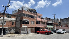
To complete the houses, people required new indebtedness, mingas[6], and help from relatives (Rodríguez, 1990). Some inhabitants even destroyed the houses entirely or partially to occupy the entire plot, including the front garden. People also built additional floors, whether to rent apartments and have an extra income or for family expansion (Ramón Navarrete & Santillán Cornejo, 2017), resulting in a vertical growth that exceeded the official plan that permitted a maximum of three floors. Currently, it is possible to find 4-, 5-, and 6-story constructions (see Figure 3), bringing a prominent level of density, sometimes even reaching overcrowding per unit. This vertical growth seems higher due to the narrow accesses to the inside of blocks, many of which only pedestrians, bicycles, and motorbikes can enter.
Some of the six housing typologies relied their design on the debt capacity of the users (see Figure 4), who were permitted to extend the built surface, depending on their means. The LUS or ‘basic’ housing type included one full bathroom and a kitchen in an area of 10 sqm on a 60 sqm lot. The ‘floor-roof’ house type included the structure (columns and beams) and one full bathroom, a kitchen, but no walls or roof, in a built area of 24.11 sqm and a plot of 60 to 80 sqm. The ‘intermediate’ house has two variations: concrete slab and corrugated plastic roof, additionally to the prior unit characteristics but with walls. The ‘tri-family’ house type consisted of plots of 9.60x9.60m and 9.60x12.80m and included three apartments; they were placed in corners with the intention of promoting commerce. The ‘bridge’ house type, created over pedestrian walkways, included a bathroom, kitchen, and a multipurpose room that could be an office, shop, or any other commercial store. This was a less popular unit, given that it did not allow any extension on the ground floor (Rodríguez, 1990).
First Migratory Movement: Rural Areas to Solanda
In the 1960s and 1970s, the Ecuadorian State passed an agrarian and agricultural reform law that affected the established ‘hacienda’ system, forcing poor campesinos and Indigenous laborers for rich landowners to leave their lands (Conejo & Andolina, 1997). These reforms distributed land to the heads of families, whereby Indigenous people and campesinos received the worst lands (Commander & Peek, 1986b). Furthermore, the State took into consideration the current oil boom, which generated development and infrastructure construction, paying special attention to urban centers like Quito and Guayaquil. The populational growth and internal migration ‘created’ a housing deficit, thus not only the State but also public and private sectors sought ‘popular’ or ‘minimum’ housing plans as necessary and to be implemented immediately (Carrión & Erazo Espinosa, 2012). This first migration wave provoked a rapid construction of large-scale projects, and Solanda became one of the paradigms in architecture and urban development for introducing the ‘Model Neighborhood’ concept. Paradoxically, the delivered houses were barely inhabitable: they did not have basic services or streets. Also, its population was mostly from the Highlands: campesinos, land workers, and traders; and generally, they were young adults.
This situation of need made inhabitants create social networks and act as a community. People collaboratively participated in the self-built process: in building house extensions and in recycling materials. They became the labor that altered the 1978 official urban design into something that comprised a community urban process. This informal, domestic, and dissident way to make architecture allowed people to inhabit their own houses, which showed an unbalance between the rational urban planning and the socioeconomic conditions of people. Planners and architects wanted the houses to be finished under their regulations and guidelines; however, this was impossible for most of the families, because they had to simultaneously cover the expenses of rent and mortgage payments. People immediately inhabited the unfinished houses despite not having basic infrastructure, such as electricity, telephone, asphalt on the streets, or public transport.
From its origins, Solanda’s social organization played a key role in the neighborhood’s configuration and development. Facing a lack of services, inhabitants formed a local committee (Ramón Navarrete & Santillán Cornejo, 2017), which oversaw communication with local authorities regarding construction works. Two of their most important achievements were to stop rising interest rates from mortgages and to provide basic services such as potable water, sewage systems, electricity, public lighting, and public transportation. In relation to the self-built process, it increased on one hand the complexity of the inside space, and, on the other hand, it consolidated the neighborhood’s identity and culture as one (Rodríguez, 1990). Most of Solanda’s inhabitants were strangers when they arrived; therefore, they relied on integrating as a community to fight for their housing rights. But also, as they were operating as a community, they saw similar opportunities to receive economic benefits from their houses, such as increasing floor numbers, renting rooms, or establishing shops.
These social networks are related to socioeconomic, political, ideological, and cultural dimensions that make Solanda a diverse and heterogenous neighborhood. These socio-spatial processes, which started with the dwelling unit and expanded to a neighborhood scale, permitted a rapid increase in population, making Solanda one of the most densely populated areas in the city.[7]
Second Migratory Movement: Ecuador in Bankruptcy
On March 8, 1999, President Jamil Mahuad declared a bank holiday, during which citizens’ savings would be frozen for 24 hours; but three days later, he signed a new executive order that froze savings for 365 days. Savers could only withdraw balances of up to 2 million sucres or USD 500 after banks operated again a week after. This action froze the deposits of more than one million people who did not see their money ever again. After the announcement, the Ecuadorian currency was devalued by more than 50%, the highest in the 20th century (Gallegos et al., 2005).
This second crisis caused a wave of labor migration, impacting working-class neighborhoods such as Solanda. Migration from Ecuador was mainly aimed at searching for jobs in other countries, especially Spain, Italy, and United States,[8] which did not necessarily mean that these emigrating people did not already have a job. Most were not part of the poorest socioeconomic group, those who did not have a fixed income; in fact, they were mostly middle and low-income class people (FLACSO & Banco Central del Ecuador, 2003). One of the consequences of this migration was that emigrants transferred money using international currencies – remittances – to relatives in Ecuador, allowing the economy to be slightly stronger, increasing consumption, and extending constructions or adequate spaces to rent. It gave rise to the so-called ‘remittance urbanism’ (Lopez, 2014), which increased population density. According to the 2000 Census, there were 22,361 inhabitants and 4,817 houses in Solanda, while in the 2010 Census, there were 78,279 inhabitants and 24,526 houses (INEC, 2001, 2010), showing a 130% increase in population and 165% in housing units. This situation affected Solanda’s traditionally residential image and it became a mixed residential and commercial neighborhood.
Another consequence of this migration was that many young people and children, whose parents had emigrated without them, were in the custody of their grandparents or relatives, which disrupted the traditional nuclear family structure and caused them, especially teenagers, to gather with people their own age (Herrera, 2005). Many adolescents created bands or gangs and disturbed Solanda’s quotidian life, including social, aesthetical, and generational aspects (Ramón Navarrete, 2017). Some activities were related to artistic expression, such as painting graffiti on walls usually agreed upon between the groups and social organizations), others played rap music in parks and alleys, and others consumed drugs in nightclubs, karaoke bars, or backstreets. Yet, this migration wave also strengthened a social network intimately related to the family, acting as links between the migrant community in their place of destination and the community who stayed in their place of origin (Herrera, 2002; Pedone, 2007).
Commercial and cultural relationships for socio-spatial production are latent in La Jota Street, given that during those years it became a social and cultural area that attracted locals and visitors. In 2011, the Municipality built the boulevard La Jota (Salazar, 2012), which included a 4,000 sqm commercial plaza located in the northern part (Gallegos & Zárate, 2014). The purpose was to allocate informal vendors in formal stands in this plaza, and, in doing so, remove the sense of informality from the streets (Salazar, 2012). Once the construction was complete, the Municipality indicated that the project provided better pedestrian circulation, gave adequate and dignified public space, such as the commercial plaza, and permitted activities to be carried out within the neighborhood and the city (Agencia Pública de Noticias de Quito, 2013).
Although the construction of the boulevard aimed to bring ‘order’ to informal commerce by displacing it and to create a uniform “aesthetic” by standardizing building façades, the socio-spatial and cultural relationships in La Jota maintained the street’s commercial character, which is integral to the neighborhood’s identity. Despite attempts to transform how public space is utilized, the diversity of people, activities, and places, and the collective’s resistance and dissent have resulted in La Jota becoming a complex network of actions in public spaces. This network goes beyond formal plans and official spaces and instead establishes forces of social cohesion that legitimize local processes that respond to their socio-spatial needs and structures.
Third Migratory Movement: Regional Crisis
Since 2015, the human migratory situation of Venezuela has become a socioeconomic issue in Ecuador, receiving the name ‘exodus’ as it became the third receptor country in receiving immigrants from this country (Olivieri et al., 2022). However, the regional economic crisis has also brought a migratory movement from countries like Cuba, Colombia, and Haiti. By 2019, more than 1.2 million people from Venezuela passed through Ecuador, 400,000 stayed, and 160,000 remained in Quito (Banco Mundial, 2021). This phenomenon has caused a diverse number of problems in integrating this population due to issues in regularizing their status, accessibility to non-precarious labor, and the intensification of their vulnerability caused by COVID-19.
In this recent economic crisis, the number of informal vendors in Quito has risen considerably[9], also impacting Solanda. The daily lives of these new inhabitants in such a traditional neighborhood produce negotiation processes in relation to co-living in multicultural places. The number of Venezuelans in Solanda has increased so much that the neighborhood has been informally renamed ‘VeneSolanda’. Their presence is mainly in public spaces as street vendors, in renting rooms, and in recreational places. One study shows that despite the difficulty in discrimination that restricts Venezuelans from having access to housing or commerce, there are actions of solidarity, especially among inhabitants (Santillán Cornejo & Ramón, 2021), such as sharing domestic areas within apartments and housing units, in hiring Venezuelans as store assistants, and allowing them to open their Venezuelan-culture businesses, like restaurants or bars, with relative ease.
The commercial street La Jota, whose official name is José María Alemán, is 1.2 km long, crosses 15 blocks, and houses more than 350 shops on its ground, second, third, and fourth floors. The flow of people is high, especially at night, and it welcomes not only residents but also visitors. Today, it is possible to notice different multicultural symbols on this street, such as flags from countries like Cuba, Colombia, and Venezuela, different dialects, people wearing their traditional clothes, restaurants offering traditional food, and especially beauty salons and barber shops targeted at and served by Venezuelans.
The intensity of activities and people in La Jota represent an important state of habitat transformation in Solanda. It has elevated the population density, presenting more services and shops that would not have emerged without the international migration. One of the main reasons for this phenomenon is that this neighborhood offers low prices in rent. Moreover, there is access to basic services, public transportation connects it to other areas of Quito in a relatively easy way, and people can be economically active through the sheer number of shops and informal economic activities.
This process of integration, which has on many occasions led to tensions and conflicts with locals (Beyers & Nicholls, 2020), has also shown that the current state is the result of constant negotiations with the neighborhood’s population and spaces. This situation has been made possible due to the quotidian interaction inhabitants have in public and private spaces.
Discussion
Solanda, a Neighborhood of Migrations
Solanda has had from the beginning a process of consolidation based on migration. To this extent, this social phenomenon has shaped the urban landscape and daily actions and interactions. This first migration process created conflicts and challenges for established residents and new inhabitants. Nevertheless, this socio-spatial situation was strengthened because people shared similar needs: to have a house and a better economic income. To achieve that, residents acted as a community and collaborated to complete their houses, as well as to fight for interest control on mortgages, access to basic services, neighborhood facilities, etc. Since then, the sense of community has been present in the neighborhood consolidation, and its leadership in public policies has remained present in the city.
During the 1998 and 1999 economic crisis, there was a massive emigration of people to European and North American countries. Given that the low-income class was the most affected by the crisis, they were the main people who were forced to leave. Many families in Solanda were separated and divided, unraveling the traditional family structure. However, emigrants sent remittances that permitted their relatives to renew, improve, or expand their houses, thus dubbed ‘remittance houses’, causing a reassertion and investment in the local communities (Lopez, 2014). This ideal of building, having a house in their hometowns, and even producing an economic income from the property, relates to the goal of migrations (Herrera, 2002). As houses changed, the expectations invested in buildings became bigger, changing likewise the urban landscape to be more active during the first decade of the 2000s (see Figure 5). At the same time, many apartments and rooms were rented to new inhabitants. Also affected by the crisis but unable to migrate to other countries, these new arrivals went to Solanda instead for being a relatively cheap place and well-located in the city. At this point, the familiar and community links were weakened due to losing the traditional residents, dismantling families, and receiving new inhabitants.
Finally, the most recent settlers from Venezuela, whose arrival commenced in 2015, saw the value of Solanda in terms of location, housing availability, low prices, access to education, healthcare, and public transportation, and the opportunity to work in formal or informal commerce. As aforementioned, its popularity with Venezuelans has led to the alternative name ‘VeneSolanda’, and as in other migratory neighborhoods in cities, there has been conflict in urban dynamics, especially related to access to work and jobs. Ecuador’s economy has been unstable, especially in recent years due to international and governmental economic policies and Covid-19 (Botello Peñaloza & Guerrero Rincón, 2022). Thus, new residents presented competition and vulnerability, causing tension and conflicts in the commercial area– La Jota Street. Yet, residents have found mutual agreement in recreational areas. Solanda includes a network of inner blocks that have parks, playgrounds, parking lots, and plazas. During weekends and on weekday evenings, it is possible to observe people carrying out various activities, such as playing football or basketball, drinking beer, eating fast food, playing, or listening to music through speakers, etc. It is during these moments and in these places that nationality, age, or ethnicity do not matter. These socio-spatial situations are consequences of the origins of the neighborhood’s process, which from the start induced inhabitants to adapt to the place and change places into self-sufficient networks. Solanda has always been a place of migration, which shaped it physically (see Figure 6) and socially, providing a sense of community. The shared feelings of being distant from one’s place of origin let inhabitants understand others’ situations and the difficulties that migration causes (Ecuadorians in Europe, or Colombians and Venezuelans in Ecuador), and be empathic to their needs (Conejo & Andolina, 1997; Parella, 2007; Pedone, 2004).
Property As a Migration Mobility Goal
The multiplicity of flows has played a fundamental role in Solanda’s transformation. The second migration wave produced an injection of economic resources that generated ‘remittance housing’, which fed the consumption capacity, the possibilities of indebtedness, and even the investment in family patrimony. The construction or extension of their houses became a great familiar project (Parella, 2007), but it brought new residents and made former inhabitants leave the neighborhood to obtain a better income. Hence, new residents started to build their own networks in domestic and public spaces.
In this paper, we aim to establish the existence of a relationship between property and migration. The aforementioned ‘urbanism of remittances’ (Barajas & García, 2016) manifests itself in the purchase or renovation of homes using money earned by immigrants, resulting in a mix of properties with unique characteristics. Houses are based on self-construction, resulting in a network of affections centered on local laborers, or simply friends and family who assist in the process. This process takes place in stages; it is dependent upon the money that arrives and the temporal singularities of each family. These construction practices that do not follow urban regulations give rise to a fragile panorama both at a social and health level, as well as at a structural level. For instance, it is common to find small and unventilated rooms, as extensions have covered the original patios. Furthermore, these structures have no seismic resistance against potential earthquakes.
Another characteristic of these progressive houses is their versatility. There is no clear distinction between public and private or domestic and commercial use. There is no replica type, only isolated units that are transforming in response to their inner needs. It should also be emphasized how the various properties’ formal and programmatic organization produces specific challenges at a community level. The presence of noise after hours, particularly in small passages or interior squares, or the practice of illicit activities related to drugs and prostitution, also has an impact on the life of the residents. Similarly, the increasing number of rooms for rent raises concerns among residents. Thus, we used cartography as a graphic method to make visible spatial situations and relationships woven by migrant affections, rather than the scenery of buildings and urban maps. As a result, we created a cartography of La Jota Street that emphasizes the number of floors in each building and the location of passages, and another cartography depicting those complex relationships, illegal actions, and dissident bodies in one of La Jota’s numerous entrance passages (see Figure 7).
Conclusion
The objective of this study was to illustrate how the origins, expansion, and consolidation of the Solanda neighborhood can be traced back to three significant migratory events that have impacted its development since the late 1970s. The first migratory wave consisted of the rural exodus of Ecuadorians to urban centers due to the agrarian reform and the oil boom; the second was that of Ecuadorians moving to Europe and North America after the national bankruptcy of 1999; and, finally, the third migratory displacement in recent years comprised the arrival of a large number of immigrants, especially from Venezuela.
Self-built housing and the production of the informal city in Solanda were born from a deficit in housing and a low quality of life in rural areas. This seemingly contradictory situation sheds light on the incapacity of the State to produce and provide adequate social housing to low-income and poor populations. This paper questions the scarcity of housing policies targeting migratory movements, which has been a constant in Ecuadorian society. The urban space has been produced by formalizing the informal and in defying urban regulations by including other land uses, such as commerce and industry; which are other means for people to receive an economic income. The migration effect has been a factor in incentivizing local economic recovery and dynamization of urban areas, such as Solanda. It is a situation that also demands a more inclusive public housing policy, urban equipment, and real urban planning that includes local practices as a way of urban life.
The examination of migration in Solanda as a social phenomenon has led to a discussion about how migratory patterns create an urban area through remittance urbanism. Beyond the self-constructions and progressive houses based on the owners’ needs, it has been feasible to demonstrate processes that have resulted in dissident urban practices, which deviate from official planning. From the start, Solanda did not follow the original urban planning: one that unrealistically established architectural guidance that exceeded the inhabitants’ economic and social conditions. Instead, the neighborhood, acting as a collaborative project, aimed to exert political, cultural, and procedural urban development by demanding facilities and services. Solanda’s community network has brought basic and social infrastructure that turned it into an independent zone within Quito.
This article opens the door to evaluating other neighborhoods in Quito, as well as in Latin America, not via static and morphological concepts of architecture and urban planning but through more local and ethnographic approaches, for instance migration policies and effects on urban composition, transnational economies, and remittance urbanism.
References

ACHIG, L. (1983). El proceso urbano de Quito (ensayo de Interpretación) (Centro de Investigaciones CIUDAD, Ed.). CAE-Ciudad.
AGENCIA PÚBLICA DE NOTICIAS DE QUITO. (2013). Lista la obra en la calle “J.” Quito Informa.
BANCO MUNDIAL. (2021). Apoyo a la migración venezolana. Banco Mundial.
BARAJAS, D., & GARCÍA, C. (2016). Urbanismos de Remesas. Viviendas (re)productivas de la dispersión. Caniche.
BEYERS, C., & NICHOLLS, E. (2020). Government through Inaction: The Venezuelan Migratory Crisis in Ecuador. Journal of Latin American Studies, 52(3), 633–657. https://doi.org/DOI: 10.1017/S0022216X20000607
BOTELLO PEÑALOZA, H. A., & GUERRERO RINCÓN, I. (2022). Informal Economy and Income Distribution in Ecuador During the COVID-19 Pandemic. Revista Facultad de Ciencias Económicas, 30(1), 11–28. https://doi.org/10.18359/rfce.5206
CABALLERO MORENO, W. G., ALEGRE, I., ARMENGOU-ORÚS, J., & AGUADO, A. (2019). Self-construction in informal settlements: a multiple-criteria decision-making method for assessing sustainability of floor slabs in Bucaramanga, Colombia. Journal of Housing and the Built Environment, 34(1), 195–217. https://doi.org/10.1007/s10901-018-9606-5
CARRIÓN, F., & ERAZO ESPINOSA, J. (2012). La forma urbana de Quito: una historia de centros y periferias. Bifea, 41(3), 503–522. https://doi.org/10.4000/BIFEA.361
COMMANDER, S., & PEEK, P. (1986). Oil exports, agrarian change and the rural labor process: The Ecuadorian Sierra in the 1970s. World Development, 14(1), 79–96. https://doi.org/https://doi.org/10.1016/0305-750X(86)90097-5
CONEJO, N., & ANDOLINA, R. (1997). Indian City. Indigenous Migration and Identity in Quito. Abya Yala News, 10(3), 6-9. https://www.abyayalanews.org/document/2428
FERGUSON, B., & NAVARRETE, J. (2003). New approaches to progressive housing in Latin America: A key to habitat programs and policy. Habitat International, 27(2), 309–323. https://doi.org/10.1016/S0197-3975(03)00013-4
Fernández-Maldonado, A. M., & Bredenoord, J. (2010). Progressive housing approaches in the current Peruvian policies. Habitat International, 34(3), 342–350. https://doi.org/10.1016/j.habitatint.2009.11.018
FLACSO, & BANCO CENTRAL DEL ECUADOR. (2003). Módulo de migración, de la Encuesta de Coyuntura del Mercado Laboral Ecuatoriano. (Luciano Martínez)
GALLEGOS, F., UNESCO, ALISEI, & CENTRO DE INVESTIGACIONES CIUDAD. (2005). La estampida migratoria ecuatoriana: crisis, redes transnacionales y repertorios de acción migratoria. (2nd ed.). Abya Yala. https://digitalrepository.unm.edu/abya_yala/406
GALLEGOS, R., & ZÁRATE, D. (2014). La Bulevarización de la Calle “J”: entre la planificación y la práctica social del espacio público en Quito. Pontificia Universidad Católica del Ecuador.
GAO, UNITED STATES GENERAL ACCOUNTING OFFICE (1986). Report to Congressional Requesters. Foreign Assistance. The Solanda Housing Guaranty Project in Ecuador. National Security and International Affairs Division.
GILBERT, A., & WARD, P. M. (1985). Housing, the State and the Poor. Cambridge University Press. https://doi.org/10.1017/CBO9780511735363
HAMDI, N. (1995). Housing without Houses: Participation, flexibility, enablement. Intermediate Technology Publications.
Herdoiza, W. (1976). Hacia un Urbanismo Popular. TYSDIC, Taller de Investigación Social, Diseño y Comunicación.
HERRERA, G. (2002). La migración vista desde el lugar de origen. Iconos. Revista de Ciencias Sociales, (14), 86–94. https://www.redalyc.org/pdf/509/50901509.pdf
HERRERA, G. (2005). Mujeres ecuatorianas en las cadenas globales del cuidado. In G. Herrera, M. C. Carrillo, & A. Torres (Eds.), La migración ecuatoriana Transnacionalismo, redes e identidades, pp. 281–300. FLACSO.
HINOJOSA BARAHONA, M. J. (2018). Between the right to the city, segregation and stigma: two case studies south of Quito, Ecuador. Anuario de Espacios Urbanos, Historia, Cultura y Diseño, 25, 77–110. https://doi.org/10.24275/FPET6359
INEC. (2001). Censo de Población y Vivienda 2000.
INEC. (2010). Censo de Población y Vivienda 2010.
INEC. (2022A). Encuesta Nacional de Empleo, Desempleo y Subempleo (ENEMDU), enero 2022.
INEC, (2022B). Proyecciones Poblacionales. https://www.ecuadorencifras.gob.ec/proyecciones-poblacionales/
KLAK, T., & HOLTZCLAW, M. (1993). The Housing, Geography, and Mobility of Latin American Urban, Poor: The Prevailing Model and the Case of Quito, Ecuador. Growth and Change, 24(2), 247–276. https://doi.org/10.1111/j.1468-2257.1993.tb00963.x
KUEVA, F. (2017). Ciudad Modelo: memoria del barrio Solanda. In M. A. Kennedy (Ed.), Modernidad y vanguardia en América Latina 1930-1970. II Jornadas Internacionales de Historia del arte y arquitectura (HiSTAA), pp. 123–148. Universidad de Cuenca.
LOPEZ, S. L. (2014). 6. Migrant Metropolis Remittance Urbanism in the United States. In Spaces of Migration in Rural Mexico and Urban USA, pp. 201–248. University of Chicago Press. https://doi.org/doi:10.7208/9780226202952-009
MARCANO, L., & RUPRAH, I. (2008). An Impact Evaluation of Chile’s Progressive Housing Program. Inter-American Development Bank.
MORA, R., GREENE, M., GASPAR, R., & MORAN, P. (2020). Exploring the mutual adaptive process of home-making and incremental upgrades in the context of Chile’s Progressive Housing Programme (1994–2016). Journal of Housing and the Built Environment, 35(1), 243–264. https://doi.org/10.1007/s10901-019-09677-9
NARANJO SERRANO, G., & ÁLVAREZ VILLARREAL, J. F. (2018). Original plan and transformation of slums in Quito. An analysis of Comité del Pueblo and La Bota, in J. Monclús & C. Díez Medina (Eds.), Ciudad y formas urbanas. Perspectivas transversales. Volumen 9 Formas urbanas y vivienda en las ciudades latinoamericanas, pp. 101–113. Institución Fernando el Católico.
OLIVIERI, S., ORTEGA, F., RIVADENEIRA, A., & CARRANZA, E. (2022). The Labour Market Effects of Venezuelan Migration in Ecuador. The Journal of Development Studies, 58(4), 713–729. https://doi.org/10.1080/00220388.2021.1988077
PARELLA, S. (2007). Los vínculos afectivos y de cuidado en las familias transnacionales Migrantes ecuatorianos y peruanos en España. Migraciones Internacionales, 4(2), 151–188. https://doi.org/10.17428/rmi.v4i13.1170
PEDONE, C. (2004). “Tú siempre jalas a los tuyos.” Cadenas y redes migratorias de las familias ecuatorianas hacia España. Universitat Autònoma de Barcelona. https://ddd.uab.cat/record/36585
PEDONE, C. (2007). La inmigración extracomunitaria y los medios de comunicación: la inmigración ecuatoriana en la prensa española. Scripta Nova: Revista Electrónica de Geografía y Ciencias Sociales, Scripta Nova: revista electrónica de geografía y ciencias sociales, 5. https://raco.cat/index.php/ScriptaNova/article/view/58967
PERALTA, E., & MOYA, R. (1979). Arquitectura y Desarrollo Nacional. Trama, 11, 1–23. https://tramaediciones.publica.la/library/publication/trama-11
PIMENTEL SÁNCHEZ, N. (2020). ¿Tomar lotes para vivir o para vender? Tráfico de tierras y práctica clientelar en la periferia urbana. Revista de Sociología, 31, 133–159. https://doi.org/10.15381/rsoc.v0i31.19279
RAMÓN NAVARRETE, P. B., & SANTILLÁN CORNEJO, A. (2017). Solanda, el caleidoscopio de la experiencia urbano-barrial. Flacso
RODRÍGUEZ, L. (1990). Las Mujeres de Solanda. Mujer, barrio popular y vida cotidiana. CEPAM.
SALAZAR, D. (2012). Revitalización Urbana calle José María Alemán - La Jota -. Bienal Panamericana de Arquitecura.
SANTILLÁN CORNEJO, A. M., & RAMÓN, P. (2021). “(Vene)Solanda”. Una etnografía a escala barrial de la población venezolana en Quito. PERIPLOS, Revista de Investigación Sobre Migraciones, 5(2), 142-168. https://periodicos.unb.br/index.php/obmigra_periplos/article/view/38083/31338
SANTILLÁN, A. (2015). Materialidad y Ficción de una ciudad segregada. Un balance de la bibliografía disponible. Cuestiones Urbanas, 3(1), 93–116. https://www.flacsoandes.edu.ec/node/63400
VILLACRÉS, J. C. (2014, MAY 21). Arquitectura Moderna en Ecuador: Quito: El Plan Jones Odriozola (1942-1945) y el Territorio - La contextualización de la ciudad moderna. Arquitectura Ecuatoriana.
ZAMBRANO, M. R., GONZALEZ, M., MEDINA, A., & ACOSTA-VARGAS, P. (2021). Modern architecture in the professional discourse: analysis of the Architectural Biennial of Quito’s 1976–92 archive using bipartite networks. Digital Scholarship in the Humanities. https://doi.org/10.1093/LLC/FQAB061
[2] Translation from Spanish to English by the authors.
[3] Institutions’ names are translated into English by the authors.
[4] Quito is located in a seismic area, which constantly affects informal constructions. Moreover, the municipality began the construction of the Metro system in 2012, to this date still not in operation. The Metro’s tunnel passes under Solanda and during its construction, it affected several houses. The vulnerability is latent in Solanda.
[5] Sector 1 was the first to be occupied. Nevertheless, the Municipality does not have any record relating to how this process took place. Over time, people started populating the neighborhood, following the original plan distribution and layout but not the architectural housing guides.
[6] Minga comes from the Quechua language, born in Andean communities. It means collective work for the benefit of the community (MINGA, undated; Sletto et al., 2020).
[7] Solanda’s original plan estimated 20,000 inhabitants. By 2010, the population was 80,000 and is currently over 100,000 people (INEC, 2018), with a large presence of people from countries like Colombia, Cuba, and Venezuela.
[8] Ecuadorians tended to choose Spain (45,2%), the United States (32%), and Italy (8,9%). Most of them were young and had a good educational level (high school and university degrees) (FLACSO & Banco Central del Ecuador, 2003).
[9] According to data from INEC, the average monthly income before the pandemic was $302, which decreased by approximately 46.36% to an average income of $162 after the pandemic. It should be noted that this income is lower than the unified basic salary and the total cost of basic household provisions (INEC, 2022).
Solanda – Quito case
Figure 1. Quito urban extension and the location of Solanda
Source: The authors.


Figure 2. Urban Plan Solanda. Foundation Mariana de Jesús and National Housing Board, 1978
Source: MIDUVI Archive [for its acronym in Spanish: Ministry of Urban Development and Housing].

Figure 3. Self-built constructions – progressive housing
Source: The authors
Solanda – Quito case

Figure 4. Housing typologies, 1978
Source: MIDUVI Archive
Solanda – Quito case

Figure 5. Houses, commerce, and public space in La Jota
Source: The authors.
Solanda – Quito case

Figure 6. Solanda development during the three migration moments
Source: The authors.
Figure 7. La Jota cartography
Source: The authors

Solanda – Quito case
Solanda – Quito case
Referencias
Achig, L. (1983). El proceso urbano de Quito (ensayo de Interpretación) (Centro de Investigaciones CIUDAD, Ed.). CAE-Ciudad.
Agencia Pública de noticias de Quito. (2013). Lista la obra en la calle “J.” Quito Informa.
Banco Mundial. (2021). Apoyo a la migración venezolana. Banco Mundial.
Barajas, D., & García, C. (2016). Urbanismos de Remesas. Viviendas (re)productivas de la dispersión. Caniche.
Beyers, C., & Nicholls, E. (2020). Government through Inaction: The Venezuelan Migratory Crisis in Ecuador. Journal of Latin American Studies, 52(3), 633–657. https://doi.org/DOI: 10.1017/S0022216X20000607
Botello Peñaloza, H. A., & Guerrero Rincón, I. (2022). Informal Economy and Income Distribution in Ecuador During the COVID-19 Pandemic. Revista Facultad de Ciencias Económicas, 30(1), 11–28. https://doi.org/10.18359/rfce.5206
Caballero Moreno, W. G., Alegre, I., Armengou-Orús, J., & Aguado, A. (2019). Self-construction in informal settlements: a multiple-criteria decision-making method for assessing sustainability of floor slabs in Bucaramanga, Colombia. Journal of Housing and the Built Environment, 34(1), 195–217. https://doi.org/10.1007/s10901-018-9606-5
Carrión, F., & Erazo Espinosa, J. (2012). La forma urbana de Quito: una historia de centros y periferias. Bifea, 41(3), 503–522. https://doi.org/10.4000/BIFEA.361
Commander, S., & Peek, P. (1986). Oil exports, agrarian change and the rural labor process: The Ecuadorian Sierra in the 1970s. World Development, 14(1), 79–96. https://doi.org/https://doi.org/10.1016/0305-750X(86)90097-5
Conejo, N., & Andolina, R. (1997). Indian City. Indigenous Migration and Identity in Quito. Abya Yala News, 10(3), 6-9. https://www.abyayalanews.org/document/2428
Ferguson, B., & Navarrete, J. (2003). New approaches to progressive housing in Latin America: A key to habitat programs and policy. Habitat International, 27(2), 309–323. https://doi.org/10.1016/S0197-3975(03)00013-4
Fernández-Maldonado, A. M., & Bredenoord, J. (2010). Progressive housing approaches in the current Peruvian policies. Habitat International, 34(3), 342–350. https://doi.org/10.1016/j.habitatint.2009.11.018
FLACSO, & Banco Central del Ecuador. (2003). Módulo de migración, de la Encuesta de Coyuntura del Mercado Laboral Ecuatoriano. (Luciano Martínez)
Gallegos, F., UNESCO, ALISEI, & Centro de Investigaciones CIUDAD. (2005). La estampida migratoria ecuatoriana: crisis, redes transnacionales y repertorios de acción migratoria. (2nd ed.). Abya Yala. https://digitalrepository.unm.edu/abya_yala/406
Gallegos, R., & Zárate, D. (2014). La Bulevarización de la Calle “J”: entre la planificación y la práctica social del espacio público en Quito. Pontificia Universidad Católica del Ecuador.
GAO, United States General Accounting Office (1986). Report to Congressional Requesters. Foreign Assistance. The Solanda Housing Guaranty Project in Ecuador. National Security and International Affairs Division.
Gilbert, A., & Ward, P. M. (1985). Housing, the State and the Poor. Cambridge University Press. https://doi.org/10.1017/CBO9780511735363
Hamdi, N. (1995). Housing without Houses: Participation, flexibility, enablement. Intermediate Technology Publications. DOI: https://doi.org/10.3362/9781780442341.000
Herdoiza, W. (1976). Hacia un Urbanismo Popular. TYSDIC, Taller de Investigación Social, Diseño y Comunicación.
Herrera, G. (2002). La migración vista desde el lugar de origen. Iconos. Revista de Ciencias Sociales, (14), 86–94. https://www.redalyc.org/pdf/509/50901509.pdf
Herrera, G. (2005). Mujeres ecuatorianas en las cadenas globales del cuidado. In G. Herrera, M. C. Carrillo, & A. Torres (Eds.), La migración ecuatoriana Transnacionalismo, redes e identidades, pp. 281–300. FLACSO.
Hinojosa Barahona, M. J. (2018). Between the right to the city, segregation and stigma: two case studies south of Quito, Ecuador. Anuario de Espacios Urbanos, Historia, Cultura y Diseño, 25, 77–110. https://doi.org/10.24275/FPET6359
INEC. (2001). Censo de Población y Vivienda 2000.
INEC. (2010). Censo de Población y Vivienda 2010.
INEC. (2022a). Encuesta Nacional de Empleo, Desempleo y Subempleo (ENEMDU), enero 2022.
INEC, (2022b). Proyecciones Poblacionales. https://www.ecuadorencifras.gob.ec/proyecciones-poblacionales/
Klak, T., & Holtzclaw, M. (1993). The Housing, Geography, and Mobility of Latin American Urban, Poor: The Prevailing Model and the Case of Quito, Ecuador. Growth and Change, 24(2), 247–276. https://doi.org/10.1111/j.1468-2257.1993.tb00963.x
Kueva, F. (2017). Ciudad Modelo: memoria del barrio Solanda. In M. A. Kennedy (Ed.), Modernidad y vanguardia en América Latina 1930-1970. II Jornadas Internacionales de Historia del arte y arquitectura (HiSTAA), pp. 123–148. Universidad de Cuenca.
Lopez, S. L. (2014). 6. Migrant Metropolis Remittance Urbanism in the United States. In Spaces of Migration in Rural Mexico and Urban USA, pp. 201–248. University of Chicago Press. https://doi.org/doi:10.7208/9780226202952-009
Marcano, L., & Ruprah, I. (2008). An Impact Evaluation of Chile’s Progressive Housing Program. Inter-American Development Bank.
Mora, R., Greene, M., Gaspar, R., & Moran, P. (2020). Exploring the mutual adaptive process of home-making and incremental upgrades in the context of Chile’s Progressive Housing Programme (1994–2016). Journal of Housing and the Built Environment, 35(1), 243–264. https://doi.org/10.1007/s10901-019-09677-9
Naranjo Serrano, G., & Álvarez Villarreal, J. F. (2018). Original plan and transformation of slums in Quito. An analysis of Comité del Pueblo and La Bota, in J. Monclús & C. Díez Medina (Eds.), Ciudad y formas urbanas. Perspectivas transversales. Volumen 9 Formas urbanas y vivienda en las ciudades latinoamericanas, pp. 101–113. Institución Fernando el Católico.
Olivieri, S., Ortega, F., Rivadeneira, A., & Carranza, E. (2022). The Labour Market Effects of Venezuelan Migration in Ecuador. The Journal of Development Studies, 58(4), 713–729. https://doi.org/10.1080/00220388.2021.1988077
Parella, S. (2007). Los vínculos afectivos y de cuidado en las familias transnacionales Migrantes ecuatorianos y peruanos en España. Migraciones Internacionales, 4(2), 151–188. https://doi.org/10.17428/rmi.v4i13.1170
Pedone, C. (2004). “Tú siempre jalas a los tuyos.” Cadenas y redes migratorias de las familias ecuatorianas hacia España. Universitat Autònoma de Barcelona. https://ddd.uab.cat/record/36585
Pedone, C. (2007). La inmigración extracomunitaria y los medios de comunicación: la inmigración ecuatoriana en la prensa española. Scripta Nova: Revista Electrónica de Geografía y Ciencias Sociales, Scripta Nova: revista electrónica de geografía y ciencias sociales, 5. https://raco.cat/index.php/ScriptaNova/article/view/58967
Peralta, E., & Moya, R. (1979). Arquitectura y Desarrollo Nacional. Trama, 11, 1–23. https://tramaediciones.publica.la/library/publication/trama-11
Pimentel Sánchez, N. (2020). ¿Tomar lotes para vivir o para vender? Tráfico de tierras y práctica clientelar en la periferia urbana. Revista de Sociología, 31, 133–159. https://doi.org/10.15381/rsoc.v0i31.19279
Ramón Navarrete, P. B., & Santillán Cornejo, A. (2017). Solanda, el caleidoscopio de la experiencia urbano-barrial. Flacso
Rodríguez, L. (1990). Las Mujeres de Solanda. Mujer, barrio popular y vida cotidiana. CEPAM.
Salazar, D. (2012). Revitalización Urbana calle José María Alemán - La Jota -. Bienal Panamericana de Arquitecura.
Santillán Cornejo, A. M., & Ramón, P. (2021). “(Vene)Solanda”. Una etnografía a escala barrial de la población venezolana en Quito. PERIPLOS, Revista de Investigación Sobre Migraciones, 5(2), 142-168.
https://periodicos.unb.br/index.php/obmigra_periplos/article/view/38083/31338
Santillán, A. (2015). Materialidad y Ficción de una ciudad segregada. Un balance de la bibliografía disponible. Cuestiones Urbanas, 3(1), 93–116. https://www.flacsoandes.edu.ec/node/63400
Villacrés, J. C. (2014, May 21). Arquitectura Moderna en Ecuador: Quito: El Plan Jones Odriozola (1942-1945) y el Territorio - La contextualización de la ciudad moderna. Arquitectura Ecuatoriana.
Zambrano, M. R., Gonzalez, M., Medina, A., & Acosta-Vargas, P. (2021). Modern architecture in the professional discourse: analysis of the Architectural Biennial of Quito’s 1976–92 archive using bipartite networks. Digital Scholarship in the Humanities. https://doi.org/10.1093/LLC/FQAB061
Cómo citar
APA
ACM
ACS
ABNT
Chicago
Harvard
IEEE
MLA
Turabian
Vancouver
Descargar cita
CrossRef Cited-by
1. Laura Estefania Vivas Yépez, Ramiro José Vivas Vivas. (2025). Percepción ciudadana del turismo en los mercados de abastos: Desarrollo y validación de una herramienta de evaluación. Siembra, 12(2), p.e8363. https://doi.org/10.29166/siembra.v12i2.8363.
Dimensions
PlumX
Visitas a la página del resumen del artículo
Descargas
Licencia

Esta obra está bajo una licencia internacional Creative Commons Atribución 4.0.
El contenido y las opiniones incluidas en los trabajos publicados por Bitácora Urbano\Territorialson de responsabilidad exclusiva de sus autores para todos los efectos, y no comprometen necesariamente el punto de vista de la Revista. Cualquier restricción legal que afecte los trabajos y su contenido (escrito y/o gráfico) es responsabilidad exclusiva de quienes los firman.Bitácora Urbano\Territorial se reserva el derecho de realizar modificaciones al contenido escrito y/o gráfico de los trabajos que se van a publicar, a fin de adaptarlos específicamente a requerimientos de edición.
Bitácora Urbano\Territorial está publicada bajo Licencia de Atribución de Bienes Comunes Creativos (CC) 4.0 de Creative Commons. El envío de colaboraciones a Bitácora Urbano\Territorial implica que los autores conocen y adhieren a las condiciones establecidas en esa licencia.