


Publicado
Flooding mapping detection and urban affectation using Google Earth Engin
Detección cartográfica de inundaciones y afectación urbana usando Google Earth Engine
DOI:
https://doi.org/10.15446/dyna.v90n229.111063Palabras clave:
Google Earth Engine; SAR; coefficient of determination; Iquitos; probability map of occurrences; detecting flooded areas (en)Google Earth Engine; SAR; coeficiente de determinación; Iquitos; mapa de probabilidad de ocurrencias; detección cartográfica de inundación (es)
Descargas
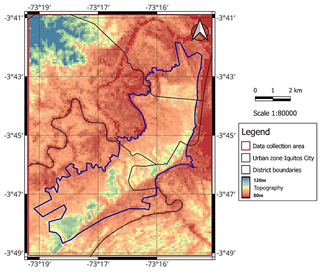
Floods are a phenomenon that can be triggered by river overflow or heavy rainfall. In this context, detecting flooded areas is crucial to document affected zones in urban environments over time. This study focuses on the development of a model based on automatic extraction of flood map images using the Synthetic Aperture Radar (SAR) of Sentinel-1 from the online Google Earth Engine (GEE) platform, specifically for the metropolitan city of Iquitos in Peru. The methodology involved mapping the flooding extent occurred over a seven-year period (2015-2021) to create a probability map of occurrences. Subsequently, identified flood areas were validated using river levels from a two-stage gauge, revealing a positive correlation. The probability map of occurrences was then superimposed on a basemap, identifying the affectation of 14.7 km of roads, 130 schools, and 91 hospitals. These findings can provide significant information for decision-making related to disaster prevention and management.
Las inundaciones son fenómenos provocados por el desborde de ríos o por intensas lluvias. En ese contexto, la detección cartográfica de inundación ayuda con un registro de zonas afectadas en entornos urbanos. Este estudio trata del desarrollo de un modelo de extracción automática de imágenes de áreas de inundación utilizando el radar de apertura sintética del Sentinel-1 desde el Google Earth Engine para la ciudad de Iquitos en Perú. Se adquirieron imágenes de 7 años para construir un mapa de probabilidad de ocurrencia de inundaciones. Las áreas inundables fueron validadas con los niveles de los ríos de dos estaciones cercanas, demostrando una correlación positiva. El mapa de probabilidad se superpuso sobre un mapa base de infraestructuras cuantificando la afectación en 14.7 km de vías vehiculares, 130 instituciones educativas y 91 hospitales. Estos resultados pueden aportar para la toma de decisiones en la prevención y la gestión de desastres.
Referencias
UNDRR (UN Office for Disaster Risk Reduction). The human cost of disasters an overview of the last 20 years 2000-2019 [Online]. Centre for Research on the Epidemiology of Disasters (CRED), 2020. [date of reference August 15th of 2022]. Available at: https://www.undrr.org/publication/human-cost-disasters-overview-last-20-years-2000-2019.
Pandey, A.C., Kaushik, K. and Parida, B.R., Google Earth Engine for Large-Scale Flood Mapping Using SAR Data and Impact Assessment on Agriculture and Population of Ganga-Brahmaputra Basin. Sustainability [Online]. 14(7), 2022. DOI: https://doi.org/10.3390/su14074210
INDECI (Instituto Nacional de Defensa Civil). Compendio Estadístico del INDECI 2020 en la preparación, respuesta y rehabilitación de la GRD [En línea]. Portal INDECI, Perú, 2020. [date of reference October 15th of 2022]. Disponible en: https://www.gob.pe/institucion/indeci/informes-publicaciones/1718819-compendio-estadistico-2020
Coffman, D.M., Urban Livelihoods and Flood Vulnerability in a State-Sponsored Resettlement Project in Iquitos, Peru, PhD Thesis, Department of Geography and Planning, University of Toronto, Canada, 2021.
McCormack, T., Campayà, J., Naughton, O., A methodology for mapping annual flood extent using multi-temporal Sentinel-1 imagery. Remote Sensing of Environment [Online]. 282, pp. 278–293, 2022. DOI: https://doi.org/10.1016/j.rse.2022.113273
Islam, M.T. and Meng, Q., An exploratory study of Sentinel-1 SAR for rapid urban flood mapping on Google Earth Engine. International Journal of Applied Earth Observation and Geoinformation [Online]. 113, 2022. DOI: https://doi.org/10.1016/j.jag.2022.103002
Gorelick, N., Hancher, M., Dixon, M., Ilyushchenko, S., Thau, D., and Moore, R., Google earth engine: planetary-scale geospatial analysis for everyone. Remote Sens Environ [Online]. 202, pp. 18–27, 2017. DOI: https://doi.org/10.1016/j.rse.2017.06.031
Nghia, B.P.Q., Pal, I., Chollacoop, N., and Mukhopadhyay, A., Applying Google earth engine for flood mapping and monitoring in the downstream provinces of Mekong river. Progress in Disaster Science [Online]. 14, 2022. DOI: https://doi.org/10.1016/J.PDISAS.2022.100235
Moothedan, A.J., Thakur, P.K., Garg, V., Dhote, P.R., Aggarwal, S.P., and Mohapatra, M., Automatic flood mapping using Sentinel-1 GRD SAR images and Google Earth Engine: a case study of Darbhangah, Bihar. The Proceedings of National Seminar on ‘Recent Advances in Geospatial Technology & Applications’, 2020.
Ezzine, A., Saidi, S., Hermassi, T., Kammessi, I., Darragi, F., and Rajhi, H., Flood mapping using hydraulic modeling and Sentinel-1 image: case study of Medjerda Basin, northern Tunisia. The Egyptian Journal of Remote Sensing and Space Science [Online]. 23(3), pp. 303–310, 2020. DOI: https://doi.org/10.1016/J.EJRS.2020.03.001
Zotou, I., Bellos, V., Gkouma, A., Karathanassi, V., Tsihrintzis, V.A., Using Sentinel-1 imagery to assess predictive performance of a hydraulic model. Water Resources Management [Online]. 34(14), pp. 4415-4430, 2020. DOI: https://doi.org/10.1007/s11269-020-02592-7
Quintana-Ortiz, J.M., Moreno-Santillan, R.D., and Pasapera-Gonzalez, J.J., Estimation of flooded areas during the El Niño Costero 2017 event using multisensor satellite data. Case Study: Lower Piura watershed (Peru). 2021 IEEE International Conference on Aerospace and Signal Processing (INCAS), Lima, Peru, 2021, pp. 1-4. DOI: https://doi.org/10.1109/INCAS53599.2021.9666917
UN-SPIDER Knowledge Portal. (2021). Step-by-step: Recommended Practice: Flood Mapping and Damage Assessment Using Sentinel-1 SAR Data in Google Earth Engine. [date of reference October 15th of 2022]. Available at: https://www.un-spider.org/advisory-support/recommended-practices/recommended-practice-google-earth-engine-flood-mapping/step-by-step
INEI (Instituto Nacional de Defensa Civil). Loreto, Resultados definitivos. Tomo I [En línea], INEI (Instituto Nacional de Defensa Civil), Lima, Perú, 2018. [date of reference October 1, 2022]. Disponible en: https://www.inei.gob.pe/media/MenuRecursivo/publicaciones_digitales/Est/Lib1561/
Asuero, A.G., Sayago, A. and Gonzálezt, A.G., The correlation coefficient: an overview. Critical Reviews in Analitical Chemistry [Online]. 36(1), pp. 41-59, 2007. DOI: https://doi.org/10.1080/10408340500526766
Cómo citar
IEEE
ACM
ACS
APA
ABNT
Chicago
Harvard
MLA
Turabian
Vancouver
Descargar cita
CrossRef Cited-by
1. Pouya Ahmadi, Mohammad Javad Valadan Zoej, Mehdi Mokhtarzade, Nazila Kardan Halvaie, Ebrahim Ghaderpour. (2025). A capsule network framework for flood mapping integrating remote sensing fusion techniques. Environmental Research Communications, 7(6), p.065031. https://doi.org/10.1088/2515-7620/ade6d0.
2. Umair Rasool, Xinan Yin, Zongxue Xu, Muhammad Awais Rasool, Mureed Hussain, Jamil Siddique, Nguyen Thanh Hai. (2025). Quantifying pluvial flood simulation in ungauged urban area; A case study of 2022 unprecedented pluvial flood in Karachi, Pakistan. Journal of Hydrology, 655, p.132905. https://doi.org/10.1016/j.jhydrol.2025.132905.
3. Mohammad Imroz, M.P. Akhtar, Meena Kumari Sharma, Fahad Alshehri. (2025). Integrated assessment of urban flooding and heat island interactions: A systematic review of geospatial technologies, machine learning approaches, and microclimate dynamics. Journal of Environmental Management, 395, p.127984. https://doi.org/10.1016/j.jenvman.2025.127984.
Dimensions
PlumX
Visitas a la página del resumen del artículo
Descargas
Licencia
Derechos de autor 2023 DYNA

Esta obra está bajo una licencia internacional Creative Commons Atribución-NoComercial-SinDerivadas 4.0.
El autor o autores de un artículo aceptado para publicación en cualquiera de las revistas editadas por la facultad de Minas cederán la totalidad de los derechos patrimoniales a la Universidad Nacional de Colombia de manera gratuita, dentro de los cuáles se incluyen: el derecho a editar, publicar, reproducir y distribuir tanto en medios impresos como digitales, además de incluir en artículo en índices internacionales y/o bases de datos, de igual manera, se faculta a la editorial para utilizar las imágenes, tablas y/o cualquier material gráfico presentado en el artículo para el diseño de carátulas o posters de la misma revista.


