


Publicado
SAFEGUARD PLAN MANAGEMENT for HERITAGE BUILDINGS: DEVELOPMENT OF A SPATIAL INFORMATION SYSTEM
Palabras clave:
safeguard plan, emergency plan, close-range photogrammetry, heritage buildings, spatial information system (es)SAFEGUARD PLAN MANAGEMENT FOR HERITAGE BUILDINGS: DEVELOPMENT OF A SPATIAL INFORMATION SYSTEM
DESARROLLO DE UN SISTEMA DE INFORMACIÓN ESPACIAL PARA EL PLAN DE SALVAGUARDIA DE EDIFICIOS HISTÓRICOS
ANGEL MUÑOZ-NIETO
Ph.D. Dep. Cartographic and Land Engineering, University of Salamanca, Spain, almuni@usal.es
DIEGO GONZALEZ-AGUILERA
Ph.D. Dep. Cartographic and Land Engineering, University of Salamanca, Spain, daguilera@usal.es
PABLO RODRIGUEZ GONZALVEZ
M.Sc. Dep. Cartographic and Land Engineering, University of Salamanca, Spain, pablorgsf@usal.es
JUAN MANCERA TABOADA
M.Sc. Dep. Cartographic and Land Engineering, University of Salamanca, Spain, juaniyoperote@usal.es
Received for review March 2th, 2010, accepted November 11th, 2010, final version November, 30th, 2010
ABSTRACT: This paper explains the methodology and criteria used in the development of a new tool for the management of a safeguard plan for historic buildings in Avila, which is a Spanish World Heritage City. As a result of a first approximation, there are many requirements to take into account: completeness, interactivity, ease of use, modularity, and low costs. Due to the characteristics of the information (spatially located, heterogenic, and provided in different formats) we consider it indispensable to create a spatial information system that is qualified for organizing all available multimedia digital information (2-D images, panoramas, graphics, text documents, and music). While the main objective of this study is to provide a simple tool for the management of historic and artistic heritage in the form of a safeguard plan, the features of the tool created here open up new possibilities for other uses in the future.
KEYWORDS: safeguard plan, emergency plan, close-range photogrammetry, heritage buildings, spatial information system
RESUMEN: Este artículo expone la metodología y los criterios adoptados para el desarrollo de una nueva herramienta para la gestión del Plan de Salvaguardia de los edificios históricos de Avila, ciudad española Patrimonio de la Humanidad. Como resultado de una primera aproximación hubo que tener en cuenta los siguientes requerimientos: compleción, interactividad, facilidad de uso, modularidad y bajo coste. Debido a las características de la información (espacialmente localizada, heterogenea y proporcionada en diversos formatos) consideramos indispensable la creación de un sistema de información espacial capaz de organizar todos los contenidos multimedia del Plan (imágenes 2D, imágenes panorámicas, gráficos, texto, documentos y música). Aunque el principal objetivo ha sido proporcionar una herramienta sencilla para la gestión del patrimonio histórico-artístico, los elementos de la herramienta creada abren nuevas posibilidades para otros usos en el futuro.
PALABRAS CLAVE: plan de salvaguardia, plan de emergencia, fotogrametria de rango cercano, patrimonio arquitectónico, sistema de información espacial
1. INTRODUCTION
Currently, the protection and safeguarding of cultural and architectural heritage is an obligation established by law in developed countries. While in 1933 the first law related to artistic historical heritage was passed in Spain, in 1985 the Artistic and Historical Heritage Law [1] became the most relevant benchmark. By means of this law, the holistic protection of unique and historic buildings was intended. In the near future, it will be interesting to remember this compulsory and legal concept of integral protection, because the law's scope should clearly include protection against fire and other risks that have been not provided until now.
Urban planning outlines special protection schemes for the maintenance of old towns, their historical setting, their uses, activities, and traffic regulations. However, no document collects emergency plans, self-protection, or fire protection and management [2,3]. The Group of World Heritage Cities in Spain (GCPHE) [4], which is constituted by Alcalá de Henares, Ávila, Cáceres, Córdoba, Cuenca, Ibiza, Mérida, San Cristóbal de la Laguna, Santiago de Compostela, Segovia, Tarragona, and Toledo have focused their efforts in this area, especially after the fire in the Bishop's Palace in La Laguna (Tenerife) in 2006 in which many paintings, ancient books, and historical documents were destroyed.
There are many heritage buildings in Avila with architectural and historical significance that could be threatened by a fire. Fire engineers [5,6] describe many causes of different natures that must be taken into account to prevent building deterioration. Natural causes of deterioration include water (direct rainfall, seepage, underground streams, and floods), fire, storms, wind (direct action, the transport of particles), vegetation, and earthquakes; chemical agents, acid rain, carbon dioxide, and pigeon droppings; while human causes include warfare, vandalism, and the misuse of the building in question.
The fire service for the city of Avila [7] has documented major disasters and their impact on the architectural heritage of Avila, such as the earthquake of 1755, several landslides, and fires at such locations as the Main Theatre (1914), the St. Isidro Atrium (1933), the Monastery of Santo Tomas (1936), the St. Vincent Atrium (1936), the Convent of Santo Tomas (1949), and the Church of San Antonio (1990). Mindful of these events, national and local governments are undertaking many efforts to promote the conservation and preservation of heritage buildings and their contents.
This research has as the primary purpose of the establishment of visual and geo-referenced inventories of the historic buildings, including documents to be handled by agents involved in the management of historic buildings in situations of intervention for their conservation and preservation. The city of Ávila, which is a city of monuments that was declared a World Heritage site by UNESCO in 1985, is the case to be studied in this paper, which is written in order to implement safeguard management based on a spatial information system.
2. SAFEGUARD PLAN FOR HERITAGE BUILDINGS
There is a need to implement a safeguard plan with efficient tools to manage heritage buildings against disasters. This management should, at least, inventory and catalogue arts elements, establish a safeguard priority order, locate these elements in their spatial context, identify risks, specify fire vehicle accesses, establish action protocols to describe how to protect fixed artwork or how to conduct the evacuation of the artworks contained in different buildings [8,9]. With this aim, the Spanish heritage cities group created the Commission on the Prevention of Fire and Civil Protection, a multidisciplinary group that uses the expertise of heritage managers and fire engineers to combat disasters.
Howard and Kara-Zaitri [8] defined fire safety management as "the application by a manager of policy, standards, tools, information and practices to the task of analyzing, evaluating and controlling fire safety."
In the absence of specific legislation covering the protection of the heritage buildings on a national level, the Fire Service and Civil Protection authorities of the city of Avila have designed a safeguard plan to ensure the safety of buildings classified as World Heritage sites that also contain artwork [10]. This plan establishes the determination of the real risk to buildings and artwork, the resources on hand for the prevention of fires, a completeness inventory of artwork, and the systems to preserve them. The information obtained for this plan will allow for the development of strategies to be used in response to emergencies.
The convergence between new tools and solutions provided by the information society and the heritage data in the context of digital information offers new possibilities for the study, conservation, representation, and diffusion of cultural heritage.
Digital photogrammetry has been shown to be a feasible and affordable tool in creating accurate 3-D models of complex objects [11]. The use of conventional cameras has proven to be a good solution for terrestrial photogrammetric surveys because it allows the gathering of heritage inventories in an easy way [12]. An overview of techniques used for the presentation of cultural heritage objects and scenes on the Web is shown in [13].
In [14,15] we found examples of Web-based applications that link spatial information (acquired through GPS) with panoramic images for heritage preservation.
This paper explains the methodology and criteria employed in the development of a tool for the management of a safeguarding plan for the historic buildings in Avila, Spain. Due to the characteristics of the information (geo-referenced, heterogenic, and multi-format) we consider it indispensable to create a spatial information system capable of organizing all available information (images, graphics, text documents) in order to facilitate decision-making. As a first approximation, there are many requirements to take into account, including completeness, interactivity, ease of use, and modularity.
3. DEVELOPMENT OF A SPATIAL INFORMATION SYSTEM FOR HERITAGE BUILDINGS
The system that we have developed in this study represents a low-cost solution for the integration of digital information. Conventional photographic and panoramic objectives (fish-eye) have been used. Also, aerial images taken from an unmanned zeppelin have been incorporated. The set has been combined with graphical and textual information (data sheets) concerning the primary characteristics of the objects located inside buildings, which include paintings, sculptures, tapestries, and other valuable artwork.
The steps followed in the workflow include the following steps, which are presented in Figure 1, below:
- capture panoramic images
- acquire aerial images
- catalogue artwork
- add art and fire technical information
- create independent virtual tours for each building
- Web design to link all virtual tours
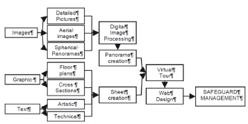
Figure 1. Spatial information system workflow
3.1. Making panoramic images
Panoramic images are the result of joining digital images that have a certain amount of overlap between them (between 10-20%). Single images are taken from the same point of view to create composite images that contain all of the visual information that can be gathered from that point of view. A historical review of the development of panorama cameras and techniques is broadly presented in [16]. More details about methods and cameras for producing panoramas, stitching, software, and Web publishing is outlined in [17].
Instrumentation. In an attempt to provide a user-friendly and low-cost solution, the following instrumentation (Fig. 2) has been used: a fisheye lens (focal length 10.5 mm), which provides a field of view that is nearly 180° connected to a digital single-lens reflex camera (Nikon D70, image size 3000 x 2000 pixels, sensor size 23.7 x 15.6 mm); and an articulated bearing assembled on a tripod to ensure stability of the camera once it has been rotated for the next image and to ensure an angular overlap between images.

Figure 2. Photographic instrumentation used to acquire panoramic images
Making spherical panoramas. Difficult lighting conditions inside historical buildings required pre-processing of individual images to obtain suitable radiometric balance. Next, each group of seven images (six azimuthal and the seventh zenithal) was stitched together automatically or manually based on the correspondence of homologous points. The result was a 360º static image for each hall (Fig. 3). For this purpose, we used the software Hugin [18]. Hugin has become a great tool not only for stitching images but also for calibrating cameras because Hugin automatically estimates barrel distortion, vignetting, and angle of view for any lens.
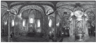
Figure 3. Spherical panoramic image in the ambulatory of the Avila Cathedral
Spherical panoramas are distributed within and outside of each of the buildings; therefore, a comprehensive and flexible tour through them is possible since there are no hidden areas. This work should plan to minimize the number of panoramas and optimize the space covered by each of them, paying particular attention to the areas of major artistic interest. Finally, every panorama is geo-referenced to an interactive floor plan (Fig. 4). The setup of hotspots is performed in order to obtain a consistent spatial positioning using the correlation of its starting position with rotations in the horizontal and the vertical planes of the spherical panoramas.

Figure 4. Panoramic view distribution for the Cathedral of Avila, including its cloister and museum
3.2. Acquiring aerial images
Since the roofs of the historical buildings are often the cause of many of security problems, due to wooden structures and frequent detachments, roofs were considered appropriate to incorporate into the information system by acquiring images from an unmanned aerial zeppelin (Fig. 5, left). A remote control was used to manipulate camera rotations (Fig. 5, right). More information regarding this device can be found in [19].

Figure 5. Unmanned aerial zeppelin with digital camera and aerial platform to control camera rotations
Aerial views provide new and interesting information concerning the state of conservation of the roofs and provide a context for external spaces. Those pictures provide a great level of data that cannot be achieved by other means (Fig. 6).
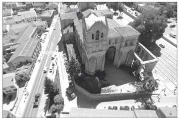
Figure 6. Aerial image of San Vicente Church taken from an unmanned aerial zeppelin
3.3. Cataloguing artwork to safeguard plan
Cataloguing works of art (paintings, sculptures, tapestries, furniture, and diverse religious objects) requires the cooperation of an art expert and a fire management expert. The art expert determines the order of importance of objects categorized based on their artistic value. The fire expert determines appropriate measures to be taken to preserve them in case of disaster.
A detailed and rigorous cataloguing in all covered buildings was achieved by making a filing card for each object (Fig. 7). These filing cards relate the following information: photography, description, location in its spatial context, physical characteristics (measures and weight), the path for evacuation, and the policies for their protection together with the necessary tools.

Figure 7. Example sheet for cataloguing artistic goods according to the safeguard plan for the Cathedral of Avila
Both graphic and textual information are geo-referenced using hyperlinks to help safeguard managers. Managers can display and manipulate a map of each building, and they can navigate interactively through panoramic images, locating artwork and displaying a catalogue card (Fig. 8).

Figure 8. Hotspot with different colors, linked to text information, suggest the order of priority for intervention
3.4. Adding safeguard technical information
Technical information, accessed via hyperlinks, has been added to the plans. This information describes the location of the nearest fire hydrants and the main and alternative routes for fire-fighting vehicles. (Fig. 9).
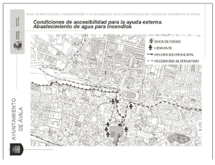
Figure 9. Floor plans with technical safeguard information about the Cathedral of Avila
All of this information is geo-referenced and spatially linked to the panoramas and floor plans. Another type of information sheet delimits the areas to be used for of security, intervention, packing, loading and transport, and storage areas. Fire engineers also consider it important to include another group of sheets for evaluating risk zones. In this case, the sheets explain access elements and facilities that can be useful in an emergency situation (Fig. 10).

Figure 10. Example of four different workspace areas to manage in case of disaster in the Cathedral of Avila
3.5. Creating virtual tours
A virtual tour is a simulation of an existing location and is usually composed of a sequence of images. We also consider a virtual tour to be a complex and coherent structure of images and other geo-referenced information. The most basic level of this structure is composed of panoramic images (cylindrical or spherical). These images are linked to each other and relate to a floor plan that allows for virtual displacements and navigation through them. The second level of the information structure consists of information related to the panoramic images (multimedia elements, such as sound effects, music, narration, and text). The safeguard plan for the historic buildings of Avila covers a total of 20 buildings, consisting mostly of churches but also shrines, archives, museums, and monasteries. Each building has been considered to be a single unit for the purpose of generating the virtual tour. To give uniformity to the project, a common template was designed. We use commercial software to link panoramas and multimedia information, customizing the interface, adapting it to the project requirements, and finally, creating the virtual tour.
3.6. Designing a Web platform for safeguard plan management.
In order to link all virtual tours to provide a broad set of data to be managed as well as to achieve a flexible and user-friendly integration of all documented buildings, a Web platform was designed. The main purpose of this Web platform is to arrange all gathered information in a simple and efficient way. The html and xml formats were used to code the links to the contents of all buildings. This allows us to talk about a genuine spatial information system.
4. EXPERIMENTAL RESULTS AND DISCUSSION
The results of this study reflect a multidisciplinary collaboration between specialists in fire engineering, photography, heritage conservation, and geomatics engineering in order to satisfy the following safeguard management requirements:
- Completeness. The system had to document entire rooms inside the heritage buildings (warehouses, halls, chapels, crypts, sacristy, and corridors). The buildings' exteriors also had to be documented, given their importance for organizing evacuation tasks and emergency works.
- Interactivity. Image exploration had to be dynamic. Users had to be able to simulate horizontal and vertical rotations and access different zoom levels interactively. Also, users needed to move through scenes fluidly.
- Ease of use. Safeguard managers, fire engineers, and heritage conservators will be the main users. They need to be able to handle a simple and effective tool to support their decisions.
- Scalability. The flexibility to make changes and the ability to incorporate new data into the system is extremely important. Historical buildings, halls, and museums are living entities. Some good examples include rehabilitation work or the organization of exhibitions, which may vary the location of the artwork and thus require updates to the system.
- Integration capacity. Because there are different types of digital documents (text, conventional, panoramic and aerial images, graphics, videos and sounds), the system had to be able to link all of them in a multimedia product.
- Low cost. One of the main goals of the spatial information system developed was to create a system for a safeguard plan management affordably.
- Modularity. We needed a modular system for adding new buildings or elements quickly.
- Multidisciplinary. Fire engineers, architects, heritage conservators, and geomatics engineers had to be able to work together. Multidisciplinary collaboration was the key to success in order to develop a useful tool. The contributions of various experts have enriched and enhanced the applications of the tool.
5. CONCLUDING REMARKS
In this paper, a spatial information system for safeguard plan management in heritage buildings has been developed. This system allows the following possibilities:
- Management, coordination, and planning actions to safeguard valuable items in case of emergencies. The provision of comprehensive and complementary graphical information in a virtual environment is a key element for improving the management of contingencies and emergencies in heritage buildings.
- Virtual tours have contributed to the dissemination of cultural heritage. The tool generated in this study satisfies technical requirements with an aim to catalogue and facilitate contingency planning needs, while being useful for cultural, informative, and recreational purposes.
- Remote access also ensures that people with disabilities can enjoy these cultural heritage sites, allowing them to access areas that they might otherwise never know because of impassable physical obstacles, such as stairs (Fig. 11).
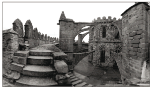
Figure 11. Access to the top of the cathedral is not public and requires visitors to pass through a narrow staircase, which is difficult or impossible for disabled people.
- Cataloguing: The information system can be used for inventory purposes to register systematically any issues (stone pathologies, repairs, actions protection, structural problems). This catalogue could also exhibit metric features.
- A multimedia DVD would allow broader dissemination to publicize the architectural and cultural heritage of Avila from a novel perspective.
In the course of this project, we have solved a number of troublesome problems. The magnitude of the work was great, as it was not limited to a single building but encompassed a large set of buildings in the city of Avila. We had to adopt a novel strategy to capture information on the function of the particularities and limitations of each building. The large amount of data generated required for this study required a major effort to coordinate the laboratory work to homogenize the final results. Finally, we had to choose a compromise solution between data quality and data size in order to optimize web publishing. However, we have generated an output specially prepared for display at tourist offices where there are no limitations on the amount of data as on the web.
Using our spatial information system and by collaborating with relevant specialists and technicians, a number of applications can be accomplished in the near future in order to increase the complexity and richness of the system:
- Add a professional narration based on historical and artistic documentation.
- Increase graphical information and images (e.g., near infrared or thermal infrared images could be used to describe other physical or chemical properties of the building facades).
- Pedagogical products with various levels of complexity and information could be generated. This aim could both increase or reduce the level of interactivity and number of multimedia applications.
- Technical intervention, diagnosis, and maintenance: In the hands of the appropriate technician, the generated documents are a basic tool for performing diagnostics or establishing maintenance plans, repairs, and rehabilitation.
ACKNOWLEDGMENTS
This work has been developed based on a cooperative agreement between the University of Salamanca and the Town Council of Avila. The main objective of the agreement is the application of new technologies to the conservation and enhancement of the city's historic and artistic heritage. Many people have contributed to the realization of this work. We especially thank the pastors of the churches who have collaborated and facilitated access to remote rooms. Without the contribution of the Fire Corps, Archaeological Council Department and the Bishopric of Avila, this research would have been impossible.
REFERENCES
[1] MINISTERIO DE CULTURA. GOBIERNO DE ESPAÑA. Artistic and Historical Heritage Law 1985 Available: http://www.mcu.es/patrimonio/docs/ley16-1985.pdf [access December 2009].
[2] Muñoz, P., Protección de Ciudades Patrimonio de la Humanidad. Available: http://www.emersis.org/prevencion/14.asp/ [Access December 2009]
[3] Pickard, R. Fire Safety and Protection in Historic Buildings in England and Ireland, J. Structural Survey, Vol. 12 (3), pp. 8-10. 1994.
[4] GRUPO DE CIUDADES PATRIMONIO DE LA HUMANIDAD. Available: http://www.ciudadespatrimonio.org/ [access December 2009]
[5] Boj, S., La Conservación del Patrimonio en la Comarca del Bajo Segura (Siglos XIX-XX): Agentes destructivos, Murcia, 2007.
[6] Watts JR., J.M., Solomon, R. E., Fire Safety Code for Historic Structures, J. Fire Technology, Vol. 38 (4), pp. 301-310. 2002.
[7] Delgado, A., Patrimonio amenazado: Incendios en la ciudad de Ávila. Not Publisher. Personal Communication 2009
[8] Martín, A., Evacuación de obras de arte en edificios del Patrimonio Nacional. Proceedings of III Jornada Técnica sobre Protección contra Incendios en Archivos, Bibliotecas y Museos 2009, Tarragona, 2009.
[9] Howard, D.J., Kara-Zaitri, C., Fire Safety Management at Passenger Terminals. J. Disaster Prevention and Management, Vol. 8, (5), pp. 362-369. 1999.
[10] Delgado, A., Ordenanza Municipal de Prevención de Incendios en los Conjuntos Históricos de las Ciudades Patrimonio de la Humanidad de España. Proceedings III Jornada Técnica sobre Protección contra Incendios en Archivos, Bibliotecas y Museos, Tarragona. 2009.
[11] Arias, P., Armesto, J., Vallejo, Lorenzo, H. Fotogrametría terrestre digital y aplicación software para el desarrollo de patrones planos J. DYNA Vol. 76, (160), pp. 7-15. 2009.
[12] Arias, P., Vázquez, S., Lorenzo, H., Rego, T., Photogrammetric survey in traditional rural constructions in Galicia (Spain). XVIII International Symposium of CIPA. Potsdam (Germany), pp.188-195, 2002.
[13] Zara, J., Virtual Reality and Cultural Heritage on the Web. Proceedings of the 7th International Conference on Computer Graphics and Artificial Intelligence. Limoges, France, pp. 101-112, 2004.
[14] Akcay, O., Altan, M.O., Design of a Tourist Information System (TIS) and Integration with a Panoramic Imaging, CIPA XIX International Symposium-New Perspectives to save cultural heritage. pp. 157-160, 2003.
[15] Akcay, O., Duran, Z., Dogru, AG., Toz, G., Altan, O., Panoramic image integration within a web-based gis application. In Proceedings of the XX Congress of ISPRS. Istanbul, Turkey . 2004.
[16] Luhmann, T., A historical review on panorama photogrammetry. In Proceedings of panoramic Photogrammetry workshop. Dresden, Germany. February 2004.
[17] Pomaska, FH., Bielefeld: Documentation and Internet Presentation of Cultural Heritage Using Panoramic Image Technology. Proceedings XVII CIPA International Symposium. Recife Brazil. October 1999.
[18] HUGIN OPEN SOURCE. http://hugin.sourceforge.net/ [Access January 2010]
[19] Gómez, J., González, D., Arias, B., Martínez, J., Low cost aerial images for heritage. 3d rendering. In Proceedings of the XXII International Cartography Conference. A Coruña, Spain. July 2005.
Cómo citar
IEEE
ACM
ACS
APA
ABNT
Chicago
Harvard
MLA
Turabian
Vancouver
Descargar cita
Visitas a la página del resumen del artículo
Descargas
Licencia
Derechos de autor 2011 DYNA

Esta obra está bajo una licencia internacional Creative Commons Atribución-NoComercial-SinDerivadas 4.0.
El autor o autores de un artículo aceptado para publicación en cualquiera de las revistas editadas por la facultad de Minas cederán la totalidad de los derechos patrimoniales a la Universidad Nacional de Colombia de manera gratuita, dentro de los cuáles se incluyen: el derecho a editar, publicar, reproducir y distribuir tanto en medios impresos como digitales, además de incluir en artículo en índices internacionales y/o bases de datos, de igual manera, se faculta a la editorial para utilizar las imágenes, tablas y/o cualquier material gráfico presentado en el artículo para el diseño de carátulas o posters de la misma revista.


