


Publicado
Study of land cover of Monte Forgoselo using Landsat Thematic Mapper 5 images (Galicia, NW Spain)
DOI:
https://doi.org/10.15446/dyna.v82n190.43725Palabras clave:
forest remote sensing, land cover, land management (es)DOI: https://doi.org/10.15446/dyna.v82n190.43725
Study of land cover of Monte Forgoselo using Landsat Thematic Mapper 5 images (Galicia, NW Spain)
Estudio de la cubierta vegetal del Monte Forgoselo mediante imágenes de Landsat TM 5 (Galicia, NW España)
Xana Álvarez-Bermúdez a, Enrique Valero-Gutiérrez del Olmo a, Juan Picos-Martín a & Luis Ortiz-Torres a
a Departamento de Ingeniería de los Recursos Naturales y Medio Ambiente, Universidad de Vigo, Vigo, España. giaf4_5@uvigo.es
Received: May 28th, 2014. Received in revised form: November 19th, 2014. Accepted: December 19th, 2014.
This work is licensed under a Creative Commons Attribution-NonCommercial-NoDerivatives 4.0 International License.
Abstract
The aim of this study was to carry out a land cover
classification of Monte Forgoselo. Remote sensing as a planning tool has been
used, specifically, a satellite image Landsat 5. We perform a supervised
digital classification of the maximum likelihood, minimum distance and parallelepipeds.
The result has been the division of Monte Forgoselo into categories of types of
vegetation, particularly in pine forest, scrub and grassland, reaching a Kappa
coefficient of 0.9762 and an overall accuracy of 98.3586%, which means good
reliability. In addition, we found that the use of such techniques can get to
make a planing of this small rural area, focusing on forestry management.
Furthermore, the use of remote sensing is considered viable in the performance
of work with more consideration.
Keywords: forest remote sensing, land cover, land management.
Resumen
En el estudio
que a continuación se describe, se pretende realizar una clasificación de la
cubierta vegetal del Monte Forgoselo. Para ello hemos utilizado la
Teledetección como herramienta, concretamente una imagen del satélite Landsat
5. Hemos realizado una clasificación digital supervisada de máxima
probabilidad, de mínima distancia y de paralelepípedos. El resultado ha sido la
división del Monte Forgoselo en categorías de estratos de vegetación,
concretamente en pinar, matorral y pradera, alcanzando un coeficiente Kappa del
0,9762 y una precisión total del 98,3586%, lo que se traduce en una buena
fiabilidad, Con nuestro estudio hemos comprobado que con el uso de dichas
técnicas se puede llegar a realizar una ordenación de esta pequeña área rural,
centrándose en el ámbito forestal. Así mismo, se concluye que el empleo de la
Teledetección se considera factible en la realización de trabajos de mayor
envergadura.
Palabras clave: teledetección forestal, vegetación, ordenación del territorio.
1. Introducción
1.1. La teledetección y sus usos
La posibilidad de la observación de la Tierra desde el espacio mediante el uso de satélites artificiales permite, en la actualidad nuevos enfoques en el estudio de los diferentes sistemas que forman el planeta [1].
Los comienzos de la Teledetección aplicada a la observación de la Tierra se pueden situar hacia la segunda mitad del siglo XIX, con la primera fotografía aérea tomada por Tournachon, en 1858 desde un globo aerostático, o la primera imagen multiespectral tomada por Du Hauron, en 1862 [2]. Obviamente desde estos orígenes, los sistemas utilizados en teledetección han evolucionado en muy diversos sentidos. Pero es interesante destacar dos: la sistematización de las medidas y la capacidad de procesamiento. Actualmente en torno a medio centenar de satélites artificiales dedicados a la observación de la Tierra, recogen diariamente información de todos los puntos del planeta. Esta situación se ve acompañada por la potencia de cálculo actual que nos ofrecen los sistemas informáticos, con la continua aparición y mejora de los programas informáticos para el tratamiento de imágenes [3], así como para la interpretación visual de estas y la clasificación digital [4,5].
Desde hace años, la teledetección se ha venido utilizando como instrumento de para la planificación a nivel urbano y ambiental, en la gestión de cultivos y recursos mineros, así como en la cartografía temática y topografía. [5-8]. En la actualidad, también sirve de herramienta en estudios arqueológicos, para el descubrimiento, conservación, y gestión de estos lugares [9].
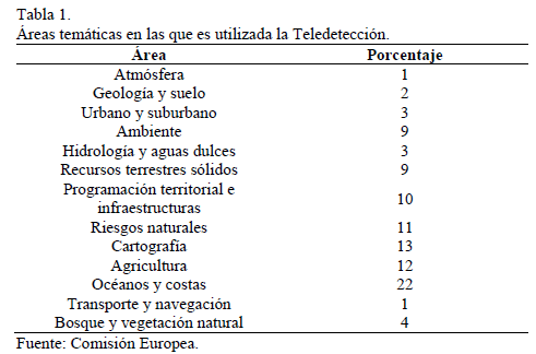
Un estudio de la Comisión Europea de 1998 (programa del Center for Earth Observation), extrae como la Teledetección, debido a sus múltiples ventajas, es utilizada en diversos campos temáticos. En la Tabla 1, se muestran las aplicaciones civiles más comunes, teniendo en cuenta que también es un recurso ampliamente utilizado en el área militar y de la seguridad aquí no representado, pero de gran importancia.
La posibilidad de llevar a cabo análisis lineales, de modo que se puedan realizar medidas de distintas variables físicas de grandes superficies a lo largo de diferentes años hace que la teledetección sea una herramienta ampliamente utilizada, reconocida y aplicable. Todo ello para la realización de análisis estadísticos con todas las variables posibles y recogidas, ya que el registro de datos es ampliamente posible gracias a su capacidad de almacenamiento. Resultando todo ello sin la necesidad de disponer de una cartografía detallada de la zona objeto de estudio, con múltiple información disponible que solo con una tecnología de este tipo puede ofrecer. Consecuentemente, algunas ventajas de esta tecnología resultan ser (1) la toma de datos no invasiva, (2) la posibilidad de realizar estudios de amplias zonas, (3) el análisis de zonas de difícil acceso, así como de aquellas áreas de las que no se dispone de cartografía, (4) el almacenamiento digital de los datos y su posterior tratamiento y procesado, (5) con amplia posibilidad de realización de análisis estadísticos, (6) y la posterior representación de una gran cantidad de información en una misma imagen, finalmente (7) la viabilidad para la realización de seguimientos lineales de las variables.
1.2. Imágenes Landsat
El valor de la información generada a partir de medidas de Landsat es bien conocido y apoyado, Cohen y Goward [10] han hecho una crónica de la función de los datos de Landsat y de su importancia en aplicaciones ecológicas.
El programa Landsat ha proporcionado datos para satisfacer una amplia gama de necesidades de información desde 1972 [11]. Lamentablemente, han ocurrido discontinuidades temporales y espaciales en la toma de datos. Por ejemplo, fallos tales como, la pérdida del Scan Line Corrector (SLC) a bordo del Landsat-7 en 2003 [12], razón por la cual no se utilizaron imágenes de dicho satélite en este estudio.
A pesar del fracaso SLC, el United States Geological Survey (USGS) mantiene la entrega de datos de Landsat-7, en una forma que cumpla con los requisitos de observación de muchas aplicaciones [10].
Hoy en día, Landsat-5 continúa proporcionando datos de calidad, aunque se espera que se quede sin combustible antes de septiembre de 2010.
1.3. La Teledetección aplicada en la caracterización de los sistemas vegetales
Centrándonos en el estudio de los ecosistemas terrestres, el principal reto que se presenta en la actualidad es comprender el papel que juegan estos ecosistemas dentro del sistema completo que forma la Tierra [1]. Para conseguir este objetivo es necesario caracterizar los sistemas vegetales a partir de la información que los satélites artificiales nos proporcionan. A nivel más local, existe gran interés por parte de administraciones y empresas en contar con sistemas que permitan automatizar la obtención de propiedades de la vegetación, incluidos bosques y cultivos, para una mejor gestión de los recursos [8].
Los estudios más recientes han diseñado diferentes métodos y técnicas para una gestión adecuada de los recursos naturales. Algunos de ellos consisten en protocolos y programas de seguimiento y monitoreo del estado ecológico de diferentes poblaciones, de modo que se han servido de las imágenes de satélites para poder hacer una estimación no solo de la cobertura del suelo, de su vegetación, de los cambios del uso del suelo que puedan haberse producido a lo largo de un periodo determinado, sino también de la detección de características concretas de la vegetación estudiada, como pueden ser la detección de enfermedades, la cobertura de las hojas u otras condiciones que solo se manifiestan en regiones del espectro electromagnético, por lo que no las detectaríamos sin el uso de esta tecnología.
Existen diversos estudios al respecto, como por ejemplo "La utilización de imágenes Landsat para cuantificar áreas de deforestación en la región de Mato Grosso, Brasil". Este proyecto está enfocado en monitorear la deforestación en el estado de Mato Grosso, en Brasil, utilizando imágenes de alta resolución de los satélites Landsat TM 4 y 5. Para ello se determinaron los Índices de Vegetación de la Diferencia Normalizada (NDVI), para calcular la distribución de biomasa [13].
Otro ejemplo es la "Inventariación de las masas de Pinus Radiata D. Don en el Bierzo (León) empleando teledetección con imágenes multiespectrales de resolución media", en ella se realzan clasificaciones con diferentes algoritmos obteniendo los mejores resultados con algoritmos de máxima probabilidad. Este trabajo sirvió para verificar que la superficie ocupada por la especie se aproxima a las estimaciones realizadas mediante estimaciones de campo [14].
"Monotoring land cover changes in a newly reclaimed area of Egypt using multi-temporal Landsat data", es otro trabajo realizado en este mismo campo. El objetivo principal de este estudio ha sido monitorizar los cambios de usos en la cubierta vegetal en el área de estudio, utilizando imágenes multitemporales de Landsat [15]. Es por ello que los inventarios de la cobertura del suelo facilitan una información de partida esencial a la hora de una correcta planificación, ordenación, uso y gestión de cualquier espacio objeto de estudio.
1.4. La Teledetección aplicada en la ordenación territorial
La ordenación de montes ha sido el pilar fundamental en la planificación forestal de España, con la excepción de los últimos años en los que se ha venido desarrollando planificaciones a otros niveles de trabajo, como es el caso de los planes forestales autonómicos. A pesar de ello, no se han realizado trabajos a una escala menor. Consecuentemente, el objetivo de la presente investigación es proponer una metodología de trabajo para la ordenación de pequeñas áreas rurales con buenos recursos forestales y, aplicarla a este espacio concreto para una mejor gestión, para el diseño y desarrollo de las medidas adecuadas teniendo presente la premisa de un desarrollo rural sostenible.
Hay estudios al respecto que merecen ser considerados en este trabajo. Como en el caso del "Análisis mediante una imagen Landsat MSS de la diversidad espacial de los usos del suelo en el Parque Nacional de Doñana", en el que se ha hecho un estudio de la diversidad espacial de los usos del suelo de dicho Parque, utilizando la información contenida en una imagen captada por el sensor MSS del satélite Landsat 4 [16].
Otro ejemplo ha sido el estudio realizado en la comarca del Bierzo, donde se ha utilizado la teledetección como herramienta para la ordenación rural sostenible de entidades locales menores [14].
Hay estudios al respecto que merecen ser considerados en este trabajo. Como en el caso del "Análisis mediante una imagen Landsat MSS de la diversidad espacial de los usos del suelo en el Parque Nacional de Doñana", en el que se ha hecho un estudio de la diversidad espacial de los usos del suelo de dicho Parque, utilizando la información contenida en una imagen captada por el sensor MSS del satélite Landsat 4 [16].
El nivel de desarrollo de la Teledetección aplicada fundamentalmente al campo de la ordenación del territorio, así como a la determinación de la vegetación de los espacios, dos campos en los que se pretende realizar este estudio está desarrollado también se encuentra muy extendido en el ámbito internacional como en los estudios realizados por Jayaraju y Khan [17] en la India; Almeida et al. [18] en Brasil; y todos los estudios que se han analizados en la revisión de Vibhute y Gawali [19]. Por todo ello, se han definido los objetivos fundamentales del estudio que se presenta, y estos son: valorar la utilidad de la Teledetección en la determinación de la cubierta vegetal de un espacio, así como su uso en la fase de ordenación forestal en entidades rurales. Así mismo, se desarrolló una metodología para la clasificación digital de la imagen, utilizando tres métodos diferentes. Dichos métodos son comparados y analizados, de forma que obtenemos el método más preciso para dicha clasificación.
Todo este proceso nos ha servido de introducción a la herramienta de la Teledetección, a lo que se entiende como estimación de la cubierta vegetal y ordenación del territorio mediante el uso de imágenes de satélites y de su clasificación digital. Por ello, también se establece un objetivo posterior a este trabajo, con el cual se pretende hacer un estudio de mayor profundidad, de mayor área de aplicación y con más "campos" a clasificar. Es decir, se pretende realizar un estudio de la vegetación y de las áreas rurales de toda la Red Natura 2000 de Galicia, para posteriormente realizar una ordenación de esta.
2. Metodología
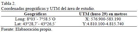
El área de estudio ha sido el Monte Forgoselo, tal y como se representa en la Fig 1. Se localiza al Noroeste de la provincia de A Coruña, a unos 10 km. del núcleo urbano de A Capela. La superficie está repartida entre los municipios de As Pontes de García Rodríguez, A Capela e San Saturnino, pertenecientes a Ferrol. Se localiza en las siguientes coordenadas.

Parte de dicho monte está incluida dentro de la Red Natura 2000, en el Espacio Protegido Xubia-Castro (Lugar de Importancia Comunitaria, LIC). Además se sitúa al Norte del Parque Natural de las Fraguas del Eume, tal y como queda representado en la Fig 1. La superficie total que ocupa el Monte Forgoselo es de 1.401,79 ha, de las cuales hay que destacar 1.004,85 ha, declaradas como Zonas de Especial Protección de los Valores Naturales (dentro de la Red Natura 2000).
La elección de este monte ha sido por varias razones. La primera, por la existencia de un Estudio de Vegetación del Monte Forgoselo realizado por IMEGA [20]. El cual facilita el trabajo, ya que es un estudio en detalle de la vegetación existente en el monte, teniendo además, planos para su mejor interpretación. Otra de las razones por la que optamos a su elección, la más importante, es debido a que se encuentra dentro de la Red Natura 2000 de Galicia (RN). Por lo que sirve de iniciación en la materia de Teledetección, para un futuro estudio que se pretende realizar en la RN.
La vegetación del Monte Forgoselo es en gran medida un auténtico mosaico de comunidades vegetales. Como vegetación dominante pueden destacarse cinco grandes grupos: (1) pastos, (2) matorrales, (3) pinares, (4) comunidades hidrófilas y (5) roquedos.
Otro tipo de vegetación tiene una representación insignificante frente a los grupos expuestos.
2.2. Imagen
El material básico que hemos seleccionado para la realización de esta investigación es una imagen tomada desde uno de los satélites de observación de la Tierra. Concretamente se ha utilizado una subescena del satélite Landsat 5 Thematic Mapper (sensor TM). Las coordenadas WRS (Worldwide Reference Systems) de la escena completa son Path/Row 205/30.
De las siete bandas del espectro electromagnético, en las que el sensor TM registra información, solamente se han utilizado seis, tres en la zona del visible (banda del azul, del verde y del rojo), una en el infrarrojo cercano y las dos del infrarrojo medio; desestimándose, por tanto, la del térmico, por su bajo poder de resolución espacial (120 m) y espectral.
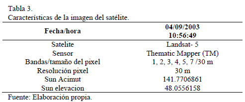
Esta imagen se tomó el 4 de septiembre del año 2003. La imagen de Landsat proviene y la distribuye el Servicio Geológico de los EU (USGS) bajo el USGS Global Visualization Viewer (GloVis). El nivel de procesamiento en el que se encuentra la imagen es el "Level 1T" (Standard Terrain Correction).
La selección de dicha imagen en el GloVis ha sido mediante una revisión de todas las imágenes que este servicio proporciona de forma gratuita. Las que se realizaron en fechas más recientes las hemos desestimado ya que estas tenían un coste asociado. Decidimos hacer una selección de años para que la imagen no fuese demasiado antigua y así evitar las posibles variaciones (incendios, cambios de uso, repoblaciones, etc.) que difieran del estudio de vegetación que se utiliza como referencia para su posterior comparación con los resultados obtenidos en este trabajo. Por todo ello el rango de años que hemos tenido en cuenta han sido desde el año 2000 al 2008. Además, se realizamos una consulta con el gestor del monte, para informarnos de las posibles variaciones nombradas anteriormente, que pudiesen tener lugar entre esas fechas, ya que el estudio de vegetación que disponemos es del año 2008. Los datos que se nos facilitan son referentes a pequeños incendios no superiores a 20 hectáreas. Por lo que la decisión final que hemos tomado es que cualquier imagen entre eses años podrá servir para el presente estudio.
Del rango de años que hemos seleccionado, también hicimos exclusiones según los meses de toma de la imagen. Decidimos analizar imágenes tomadas entre los meses de junio y septiembre, ambos incluidos, por varias razones. Principalmente porque esos meses coinciden con el verano, consecuentemente la probabilidad de que la fotografía se realizara en días sin cielos cubiertos de nubes es más elevada. Además de que en esos meses la incidencia del sol es más vertical.
Finalmente, después de analizar todas las fotografías, descartando aquellas tomadas en días con nubosidad en la zona de estudio, seleccionamos 2 imágenes, una de julio y otra de septiembre, ambas del año 2003. Como en este estudio pretendemos realizar un análisis de la cubierta vegetal, con una imagen es suficiente. Finalmente seleccionamos la imagen de septiembre, cuyas características a destacar se reflejan en la Tabla 3.
2.3. Software
Para este estudio empleamos diversos programas. En el tratamiento digital de la imagen utilizamos el programa Environmental Visualization Images (ENVI), concretamente la versión 4.5. Para la generación de cartografía, empleamos el ArcGis 9.3, tanto para realizar el plano de situación como para el de zonificación final.
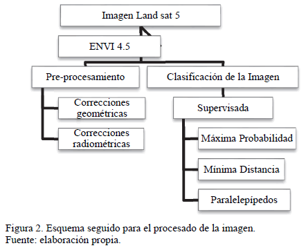
2.4. Pasos seguidos para el procesado de la imagen.
En la Fig 2 se esquematiza el procesado que hemos llevado a cabo. Por un lado el pre-procesado, con las correcciones correspondientes, y posteriormente, la clasificación digital de la imagen.
2.4.1. Pre-procesado de la imagen
Una vez seleccionada la zona de estudio, iniciamos el tratamiento de la imagen, para así, posteriormente poder analizarla. El primer paso consiste en aplicar una serie de algoritmos que eliminan los errores del registro, debidos a las condiciones existentes en el momento de toma de la misma y a los errores de captación. Parte de estas anomalías ya han sido corregidas en los centros de recepción y distribución, como sucede con la imagen que se utiliza en este estudio, la cual la hemos descargado con la corrección geométrica.
Correcciones geométricas
Este proceso tiene como fin rectificar la imagen registrada por el satélite, ya que, debido a su órbita, la escena no coincide, normalmente, con la realidad geográfica, debiéndose transformar las coordenadas espaciales de cada punto que constituye la imagen a coordenadas de un sistema de referencia, sin modificar su intensidad radiométrica. De esta forma se realiza el ajuste de la imagen original a un sistema de coordenadas UTM, obteniéndose una nueva imagen que puede ser integrada, geométricamente, en un mapa. Esta corrección puede hacerse de varias formas, en este caso, el centro de recepción ofrece la imagen con las correcciones geométricas realizadas. Concretamente, el método que ha utilizado ha sido la corrección orbital. Este método aplica transformaciones inversas a las que realiza el sensor durante la adquisición de la imagen. Este tipo de corrección es posible siempre que la fuente de error sea conocida [21].
Correcciones radiométricas
Este tipo de correcciones tienden a eliminar las alteraciones en el registro de la imagen como consecuencia de las condiciones atmosféricas existentes en el momento de su captación. La presencia de aerosoles, partículas en suspensión y vapor de agua, dispersa la radiación transmitida entre la superficie y el sensor. Esta se evidencia, en la imagen, por alteraciones del nivel digital, cuya distribución es heterogénea, pudiendo aparecer partes más afectadas que otras. La corrección atmosférica la hemos mediante la aplicación del ENVI "Landsat TM Calibration". La cual elimina el efecto atmosférico por substracción del valor mínimo del nivel digital y transforma los niveles digitales a valores de reflectancia [22].
2.4.2. Reconocimiento visual
Antes de realizar la clasificación digital, ha sido necesario un estudio de la imagen real del espacio. En la Fig 3 se refleja la imagen real del monte y de sus alrededores que hemos elaborado.
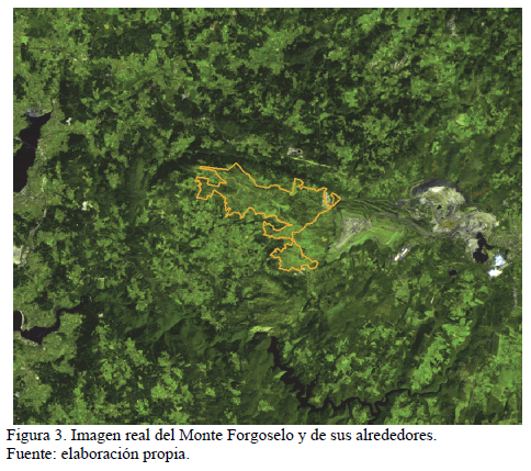
De esta forma hemos podido detectar aquellas zonas que ya vienen definidas y categorizadas en el estudio de vegetación del IMEGA [20], para así poder localizarlas en nuestra imagen.
Hemos analizado toda la escena, especialmente el monte Forgoselo y sus alrededores. Hemos localizado las zonas de praderas, las zonas de matorral, ríos, canteras, minas, caminos, eólicos, etc. Realizamos un análisis en profundidad para familiarizarnos con el espacio y conocerlo al detalle para poder, posteriormente, trabajar en ella.
En dicha figura se puede diferenciar claramente, elementos como pueden ser las zonas de agua, la mina, cantera, zonas con más vegetación que otras, etc.
2.4.3. Clasificación de la imagen
Como en el caso anterior, hemos utilizado el ENVI para realizar la clasificación digital de la imagen. Para ello, partimos de unos niveles digitales continuos, medidos por los sensores, para obtener una escala nominal o categoría, de este modo se asigna una categoría definida a cada pixel. El nivel digital de un píxel clasificado es el identificador de la clase o categoría en la que se haya incluido. Estas clases pueden describir distintos tipos de cubiertas o bien intervalos de una misma categoría de interés.
Partiendo de un conocimiento de la zona de esta exposición, a través del estudio de vegetación realizado por IMEGA [20], se ha realizado esta clasificación mediante el método supervisado, ya que éste parte de cierto conocimiento de la zona de interés. De esta forma es posible identificar sobre la imagen de satélite, áreas que puedan representar adecuadamente cada cubierta que vaya a ser incluida en la leyenda del trabajo. Hemos obtenido como resultado de la clasificación digital una cartografía e inventario de datos objeto de estudio. En este caso pretendemos realizar la categorización de la superficie en estratos homogéneos de vegetación. Para ello se hemos llevado a cabo diversas fases típicas de la clasificación digital de imágenes, estas son: (A) localización de las áreas de entrenamiento AE, (B) fase de entrenamiento, (C) fase de asignación y finalmente (D) comprobación y verificación de los resultados.
A. Localización de las AE
Para la localización de las AE, nos hemos ayudado del estudio de vegetación del IMEGA [20]. En su contenido existen planos de los cuales sacamos la información necesaria, para ver qué categorías serán necesarias definir, y dónde se sitúan.
B. Fase de entrenamiento
La clasificación digital la iniciamos definiendo la leyenda de trabajo; las clases o categorías que se pretenden discriminar en la imagen. El proceso de clasificación se basa en los valores numéricos que definen cada categoría, es decir, es necesario obtener el rango de niveles digitales que identifican cada categoría en cada banda de la imagen empleada en la clasificación. Para ello se emplean las AE.
La eficacia del proceso y la calidad del resultado obtenido dependen directamente del rigor con que se hayan definido las categorías, de ahí la importancia y la complejidad de esta fase. Dicha leyenda consta de los siguientes elementos: pinar, matorral, pradera y agua.
En una primera prueba hicimos este paso únicamente para la zona de estudio, pero se comprobamos que el resultado se podría mejorar si optabamos por la utilización de más territorio del que ocupa el monte, debido a que se obtenían pocas AE. Además, de esta manera consiguimos tener una AE más, al poder incluir el agua de los alrededores. Otra de las decisiones tomadas ha sido no crear AE para la cantera, la mina y la escombrera. Debido a que, principalmente este estudio se centra en la cubierta vegetal y zonas forestales.
Una vez concluimos la selección de las AE mediante la digitalización de polígonos, el software procesa la información para el conjunto de las bandas y elabora las estadísticas correspondientes a cada categoría.
C. Fase de asignación
El objetivo que perseguimos en esta fase es asignar cada píxel de la imagen a una de las categorías de la leyenda de trabajo. Dicha asignación se basa en el valor de radiancia espectral del píxel a clasificar, es decir, su nivel digital, y la semejanza de dicho valor con los datos estadísticos que describen cada categoría de la leyenda.
Existen diferentes formas de abordar esta fase. Las técnicas estadísticas corrientemente usadas para evaluar cómo de similares son unas signaturas respecto a otras, se denominan clasificadores.
Todos los clasificadores se basan en el establecimiento de fronteras estadísticas que permitan establecer asignaciones. Los clasificadores seleccionados han sido los que a continuación se describen:
Clasificador mínima distancia
Consiste en asignar cada píxel a la categoría más cercana, es decir, a aquella que minimice la distancia geométrica entre el píxel y el centro de la clase.
Primero se calculan las distancias a los centros de todas las categorías de la leyenda y finalmente se escoge la mínima. Para ello se calcula la distancia euclídia, cuya expresión es la siguiente:

Donde dx,A = distancia entre el píxel y la categoría A; Ndx,i = nivel digital de la banda i del píxel a clasificar; NdA,i = media de la categoría en la banda i.
Las principales ventajas del algoritmo de clasificación son su sencillez y la rapidez con que se ejecuta. La calidad de la imagen resultante depende en gran medida del solape entre clases, de forma que, en la medida en que el solape vaya disminuyendo, la clasificación irá mejorando. Por otra parte, y puesto que siempre existe una clase más cercana, no deja nunca píxeles sin clasificar. Esta circunstancia puede provocar errores de comisión importantes ya que, puede haber dejado de incluir en la leyenda categorías claramente presentes en la escena, categorías que quedarán confundidas con otra u otras de las propuestas inicialmente.
Clasificador de paralelepípedos
Este clasificador se basa en la creación de "cajas" (o paralelepípedos) usando para definir su tamaño alguna medida de la dispersión de los valores detectados, como la desviación típica o la diferencia normalizada de rangos de reflectancia de las áreas de entrenamiento.
El algoritmo de clasificación es en este caso todavía más rápido que en el caso anterior. La potencia de cálculo requerida es muy pequeña dado que se basa en operaciones matemáticas muy sencillas y rápidas de ejecutar.
La sencillez de este método hace que efectivamente sea un clasificador muy rápido, pero también propenso a clasificaciones incorrectas. Debido a la correlación de información entre las distintas bandas espectrales, los píxeles tienden a agruparse de forma que las cajas capturan píxeles que deberían ser asignados a otras categorías.
Otro de los problemas que surge es que las cajas tienden a solaparse. En este caso, el píxel cuyo valor cae en una zona de solape, es asignado a la última signatura, de acuerdo con el orden que fueron introducidas, sin realizar ningún otro tipo de comprobación.
Clasificador máxima probabilidad
En el caso de este clasificador, la distribución de valores de radiancia espectral de cada área de entrenamiento es descrita como una función de densidad, en base a la estadística Bayesiana. El clasificador calcula la probabilidad de que un determinado píxel pertenezca a una categoría y asigna el píxel a la categoría que proporciona la máxima probabilidad.
Este clasificador es el más preciso de los métodos descritos anteriormente, pero también es el más complejo. Es el que ofrece mejores resultados, de hecho es el más empleado en teledetección por ajustarse con mayor precisión a los datos originales. Como desventaja de este método, necesita un gran volumen de cálculo y consecuentemente de tiempo para realizarse.
D. Comprobación y verificación de resultados
Como resultado de la clasificación digital supervisada hemos obtenido una división del territorio en categorías. El hecho de utilizar técnicas automáticas y procedimientos ya probados por otros autores, no debe hacer que se asuma la fiabilidad del producto.
Toda clasificación lleva consigo un cierto margen de error en función de la metodología empleada y de la información de partida. Por esta razón, si se pretende dotar de validez el trabajo realizado, es necesario que apliquemos diversos procedimientos de verificación que permitan calcular el error cometido y, en función de él, evaluar la calidad del producto finalmente obtenido y su potencial de aplicabilidad.
El método más inmediato para estimar la precisión conseguida, se basa en calcular las diferencias entre el inventario ofrecido por la clasificación y el ofrecido por otras fuentes que se consideren fiables, como puede ser cartografía previamente elaborada o por el propio trabajo de campo. Para ello se crean matrices de confusión a partir de la comparación píxel a píxel de la "imagen verdad" y las obtenidas por clasificación digital. Estas matrices dan información muy valiosa del error, de comisión y de omisión, existente entre ambas fuentes de información.
2.5. Zonificación del Monte Forgoselo
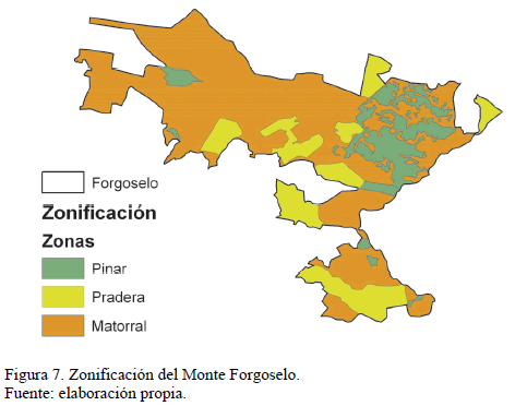
A partir de esta categorización de la cubierta vegetal, hemos realizado una ordenación del territorio atendiendo al uso del suelo. Para ello utilizamos la herramienta ArcGis 9.3.
Para realizar el plano definitivo de la categorización del suelo hemos tenido en cuenta la clasificación final obtenida en el tratamiento anterior. Se ha analizado la información emanada del proceso, y se ha tratado de forma que se obtengan tres categorías zonales atendiendo a los usos forestales. Estas categorías se han denominado como: (1) pinar, (2) matorral y (3) pradera.
Hemos querido mantener la designación inicial ya que esta representa la realidad del territorio. La categoría de agua proviene de zonas cercanas al área de estudio, por eso en la zonificación final no la incluimos.
3. Resultados
Los resultados que hemos obtenido de la clasificación digital supervisada llevada a cabo, han sido la división del Monte Forgoselo y de las zonas cercanas a él, en categorías de estratos de vegetación. Según el clasificador utilizado, la clasificación de la imagen ha sido diferente. Dichas diferencias se muestran en las Figs. 4, 5 y 6.
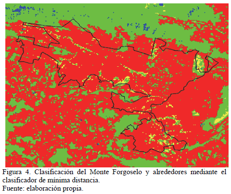
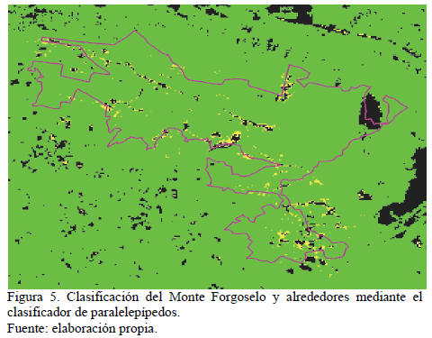
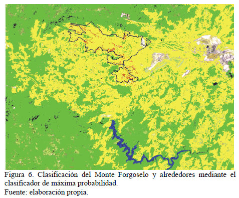
En dichas imágenes se puede observar el resultado de cada una de las clasificaciones que hemos realizado. Si se observan detenidamente, se puede hacer una valoración inicial de cada clasificador utilizado. En los dos primeros casos (mínima distancia y paralelepípedos), se puede ver a simple vista que los resultados obtenidos no son muy buenos, ya que hacen una clasificación en la que categorizan mayoritariamente el territorio en una única clase. Esto quiere decir que, en el caso del clasificador de mínima distancia la categoría mayoritaria corresponde a "Pradera", representando un total del 76,09 %, mientras que la categoría "Matorral" solo está representada en un 12,88 %. En el caso del clasificador mediante paralelepípedos sucede que, el porcentaje de pinar es muy elevado (83,05%), mientras que zonas categorizadas como praderas son inexistentes dentro del espacio, y poca representación tienen en toda la zona considerada (3,96%).
Datos que no se corresponden con la realidad del territorio. Además, el coeficiente Kappa obtenido en estos casos es de 0.2921 (mínima distancia) y 0,2387 (paralelepípedos).
En cuanto al tercer clasificador utilizado (máxima probabilidad), hemos obtenido mejores datos. En relación a este último, en la Tabla 4 se presenta la matriz de confusión obtenida para esta clasificación concreta.
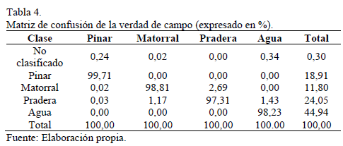
En este caso, el mejor resultado ha sido para la clase Pinar, que obtiene un 99,71%, por lo que el 0,29% de los píxeles han sido mal clasificados. El peor resultado que hemos obtenido en esta clasificación ha sido para la clase de Pradera con un 97,31%, por lo que presenta un 2,69% de píxeles mal clasificado.
El coeficiente Kappa obtenido ha sido del 0,9762 y la precisión total fue del 98,3586%. Resultados que se interpretan como fiables, por lo que la clasificación que hemos obtenido del espacio es realmente buena y muy cercana a la realidad del territorio.
Por todo lo anterior, el paso final ha sido procesar esta clasificación para obtener una zonificación del territorio. Zonificación del Monte Forgoselo en la que se han obtenido tres unidades de zonificación: Pinar, Matorral y Pradera. El resultado final ha sido el que se muestra en la Fig 7.
4. Conclusiones
Nuestra clasificación incurre en un error inferior al 2% y la concordancia del mapa con la realidad del territorio obtenido en el estudio del IMEGA [20] es superior al 95%. Mientras que si comparamos nuestro estudio con otros realizados, como la investigación realizada por DE MESA[23] con un error del 2% y una correspondencia con la realidad del 80%, valores claramente inferiores y menos precisos que los nuestros. Es por ello que nuestro método es perfectamente aplicable a la realidad del terreno.
Las técnicas descritas a través de la manipulación de imágenes del satélite Landsat 5 han resultado ser viables y eficaces, para la determinación de la cubierta vegetal y para la posterior zonificación del espacio.
La metodología seguida en este estudio, basada en el análisis digital de imágenes, permite ahorrar costes en la generación de cartografía temática.
De los distintos clasificadores utilizados, para estudios semejantes a este, el que mejor resultados ofrece y de mayor fiabilidad es el clasificador de máxima probabilidad.
Con este estudio lo que se ha pretendido es, principalmente, ver si la teledetección es una buena herramienta de trabajo para la estimación de la cubierta vegetal. Como el resultado ha sido positivo, y teniendo en cuenta que este estudio ha sido de un espacio concreto y ha servido como introducción a la metodología, lo que se pretende es darle continuidad. De esta forma, en un futuro, será factible la realización de un trabajo de mayor envergadura.
El aporte de nuestro trabajo consiste en la utilización de la Teledetección como herramienta de identificación de los diferentes usos del suelo, de modo que con la aplicación de la metodología que describimos en nuestro artículo se pueda realizar una zonificación de un espacio concreto y conocer cuál es su cobertura a partir de dicha tecnología. Sin estudios semejantes, y con la aplicación de esta tecnología para otros campos como puede ser la evaluación de la dinámica de cultivo de palma en distintas épocas [24] resulta extremadamente útil para los profesionales actuales. Todo ello con una componente innovadora la cual ahorrará numerosos costes y esfuerzos a la hora de realizar estos trabajos ya que no será necesario desplazarse hasta el lugar, ni recorrer toda la superficie que queremos estudiar.
Referencias
[1] ESA. The changing Earth: New scientific challenges for ESA's Living Planet. ESA Bulletin (129), 2007, 10 P
[2] European Space Agency, 2006.
[3] Cohen, C.J., Early history of remote sensing. Washington: Proc. of the 29th Applied Imagery Pattern Recognition Workshop. IEEE Computer Society, 2000. http://doi.ieeecomputersociety.org/10.1109/AIPRW.2000.953595
[4] Wulder, M.A. and Franklin, S.E., Remote sensing of forest environments, introduction: The transition from theory to information. In Wulder, M.A. and Franklin, S.E., eds. Remote sensing of forest environments: Concepts and case studies. Dordrecht, Holland. Kluwer Academic Publishers. pp. 3-12, 2003.
[5] Lillesand, T.M., Kiefer, R.W. and Chipman, J.W., Remote sensing and image interpretation. 5 Ed., John Wiley & Sons. Ltd, 2004.
[6] Chuvieco, E., Teledetección ambiental: La observación de la Tierra desde el espacio. Barcelona: Ariel Ciencia, 2002.
[7] Pinilla, C., Elementos de teledetección. Madrid: RA-MA Editorial, 1995.
[8] Barrett, E.C., Introduction to environmental remote sensing. Routledge, 2013.
[9] Sirén, A., Tuomisto, H. and Navarrete, H., Mapping environmental variation in lowland Amazonian rainforests using remote sensing and floristic data. International Journal of Remote Sensing, 34 (5), pp. 1561-1575, 2013. https://doi.org/10.1080/01431161.2012.723148
[10] Parcak, S.H., Satellite remote sensing for archaeology. New York: Routledge, 2009.
[11] Cohen, W. and Goward, S., Landsat's role in ecological applications of remote sesing. BioScience, 54 (6), pp. 535-545, 2004. doi: 10.1641/0006-3568(2004)054[0535:lrieao]2.0.co;2
[12] Williams, D.L, Goward, S. and Arvidson, T., Landsat: Yesterday, today and tomorrow. Photogrammetric Engineering and Remote Sensing, 72 (10), pp. 1171-1178, 2006. https://doi.org/10.1080/01431161.2012.723148
[13] Markham, B.L, Storey, J.C, Williams, D.L, and Irons, J.R., Landsat sensor performance: History and current status. IEEE Trasactions on Geoscience and Remote Sensing, 42 (12), pp. 2691-2694, 2004. https://doi.org/10.1109/TGRS.2004.840720
[14] Román, Y.A., La utilización de imágenes de Landsat TM para cuantificar áreas de deforestación en la región de Mato Grosso, Brasil. Brasil: Geology, 2004.
[15] Rodríguez, J.R., Álvarez, M.F., Asenjo, A., Fernández, A, and Quintano, C., Inventariación de las masas de Pinus Radiata D. Don en el Bierzo (León) empleando teledetección con imágenes multiespectrales de resolución media. España: Cuad. Soc. Esp. Cienc. For. 19:, pp.175-180, 2005.
[16] Bakr, N., Weindorf, D.C., Bahnassy, M.H., Marei, S.M., and El-Badawi, M.M., Monotoring land cover changes in a newly reclaimed area of Egypt using multi-temporal Landsat data. Egypt: Applied Geology, 30 (4), pp. 592-605, 2010. https://doi.org/10.1016/j.apgeog.2009.10.008
[17] Cuevas, J.M. y González, F., Análisis mediante una imagen Landsat MSS de la diversidad especial de los usos del suelo en el Parque Nacional de Doñana. España: Investigación Agraria, Sistemas y Recursos Forestales. 2 (1) pp. 89-98, 1993.
[18] Jayaraju, N. and Khan, J.A., Remote sensing and geographical information as an aid for land use planning and implications to natural resources assessment: Case study, South India. In: Developments in soil classification, land use planning and policy implications, Springer Netherlands, pp. 577-590, 2013. https://doi.org/ 10.1007/978-94-007-5332-7_33
[19] Almeida, P., Altobelli, A., D'Aietti, L., Feoli, E., Ganis, P., Giordano, F. and Simonetti, C., The role of vegetation analysis by remote sensing and GIS technology for planning sustainable development: A case study for the Santos estuary drainage basin (Brazil), Plant Biosystems 148 (3), pp 540-546, 2014. https://doi.org/ 10.1080/11263504.2014.900130
[20] Vibhute, A.D. and Gawali, B.W., Analysis and modeling of agricultural land use using remote sensing and geographic information system: A review. International Journal of Engineering Research and Applications (IJERA), 3 (3), pp. 81-91, 2013.
[21] IMEGA., Estudio de la vegetación del Monte Forgoselo. España: IMEGA, 2008.
[22] Otero, I., Paisaje, teledetección y SIG. Conceptos y aplicaciones. España: Fundación Conde del Valle Salazar, 1999.
[23] Chuvieco, E., Fundamentos de teledetección espacial. España: 3ª Ed. revisada, 1996.
[24] Polanco-Lopez de Mesa, J.A. Teledetección de la vegetación del Páramo de Belmira con imágenes Landsat, DYNA, 79 (171), pp. 222-231, 2012.
[25] López-Duque, A. and Botero-Fernández, V., Estimation of land use conflicts due to the dynamic of african Palm cultivation using remote sensing in Cesar, Colombia. DYNA, 81 (186), pp. 65-72, 2014. https://doi.org/10.15446/dyna.v81n186.38047
X. Álvarez-Bermúdez, es graduada en Ingeniería Forestal en 2014 e Ingeniera Técnica Forestal en 2009, con un MSc en Tecnología Medioambiental en 2010, todos ellos en la Universidad de Vigo, Galicia, España. Realiza actualmente la Tesis Doctoral. Es investigadora del Grupo de Investigación AF4 del Departamento de Ingeniería de los Recursos Naturales y Medio Ambiente desde el 2008 hasta la actualidad, realizando trabajos relacionados con los espacios y recursos naturales.
E. Valero-Gutiérrez del Olmo, es Dr. e Ingeniero de Montes por la Universidad Politécnica de Madrid, MSc en Ordenación del Territorio por la Universidad Politécnica de Valencia. Es director y profesor de la Escuela de Ingeniería Forestal de Pontevedra, Universidad de Vigo, Galicia, España. Es director del Grupo de Investigación AF4 del Departamento de Ingeniería de los Recursos Naturales y Medio Ambiente donde dirige numerosos proyectos relacionados con la gestión de los espacios naturales y sus recursos. E.mail: evalero@uvigo.es
J. Picos-Martín, es Dr. E Ingeniero de Montes por la Universidad de Vigo, España. Profesor de la Escuela de Ingeniería Forestal de Pontevedra, Universidad de Vigo, Galicia, España. Es investigador del Grupo de Investigación AF4 del Departamento de Ingeniería de los Recursos Naturales y Medio Ambiente donde participa en numerosos proyectos relacionados con la gestión de los espacios naturales y sus recursos. E-mail: jpicos@uvigo.es
L. Ortiz-Torres, es Dr. E Ingeniero de Montes por la Universidad Politécnica de Madrid, España. Es profesor de la Escuela de Ingeniería Forestal de Pontevedra, Universidad de Vigo, Galicia, España. Investigador del Grupo de Investigación AF4 del Departamento de Ingeniería de los Recursos Naturales y Medio Ambiente, dirigiendo numerosos proyectos de biomasa forestal y energías renovables. E-mail: lortiz@uvigo.es
Cómo citar
IEEE
ACM
ACS
APA
ABNT
Chicago
Harvard
MLA
Turabian
Vancouver
Descargar cita
CrossRef Cited-by
1. Michael Ezequiel Gómez-Rodríguez, Francisco José Molina-Pérez, Diana María Agudelo-Echavarría, Julio Eduardo Cañón-Barriga, Fabio de Jesús Vélez-Macías. (2017). Cambios en la cobertura del suelo en el municipio de Nechí: Una aproximación al impacto ambiental de la minería, 1986-2010. Revista Facultad de Ingeniería, 26(45), p.149. https://doi.org/10.19053/01211129.v26.n45.2017.6423.
Dimensions
PlumX
Visitas a la página del resumen del artículo
Descargas
Licencia
Derechos de autor 2015 DYNA

Esta obra está bajo una licencia internacional Creative Commons Atribución-NoComercial-SinDerivadas 4.0.
El autor o autores de un artículo aceptado para publicación en cualquiera de las revistas editadas por la facultad de Minas cederán la totalidad de los derechos patrimoniales a la Universidad Nacional de Colombia de manera gratuita, dentro de los cuáles se incluyen: el derecho a editar, publicar, reproducir y distribuir tanto en medios impresos como digitales, además de incluir en artículo en índices internacionales y/o bases de datos, de igual manera, se faculta a la editorial para utilizar las imágenes, tablas y/o cualquier material gráfico presentado en el artículo para el diseño de carátulas o posters de la misma revista.


