


Publicado
Hydrologic and hydraulic simulations for use in macrodrainage designs for gully management and recovery
Simulación hidrológica e hidráulica para el diseño de macrodrenaje para la gestión y recuperación de cárcavas
DOI:
https://doi.org/10.15446/dyna.v84n202.61254Palabras clave:
Erosion, drainage system, SCS method, Nazareno (MG) (en)Erosión, sistema de drenaje, método SCS, Nazareno (MG) (es)
Descargas
Recibido: 25 de noviembre de 2016; Revisión recibida: 5 de julio de 2017; Aceptado: 24 de julio de 2017
Abstract
Runoff on susceptible terrains that is not associated with adequate drainage causes soil erosion, as gullies. Gullies and drainage continue to be major issues in reclamation projects since soil erosion can be reactivated after the application of recovery measures. This paper describes a low-cost project framework for macrodrainage for a gully in Nazareno (MG, Brazil) to provide support to gully management and recovery. We used a simple methodology with the application of Geographic Information Systems (GIS) and concentrated hydrologic and hydraulic models (freely available softwares). The basin has steep slopes (8 to 20%) and the water flows mainly to the northwest, which contribute to exacerbate erosion problems. We studied the effect of environmental conditions on different simulations to elaborate a drainage system project using the free software tools. Therefore, the findings of this paper can aid gully management and recovery for this and other areas with similar issues.
Keywords:
Erosion, drainage system, SCS method, Nazareno (MG).Resumen
Escurrimiento superficial en terrenos susceptibles sin asociación con el drenaje adecuado causa erosión del suelo. Las cárcavas y el drenaje son importantes para proyectos de recuperación, ya que la erosión puede ser reactivada después de la aplicación de técnicas de recuperación. Describimos un proyecto de bajo costo para macrodrenaje en Nazareno (MG, Brasil), proporcionando suporte a la gestión y recuperación de cárcavas. Utilizamos una metodología con la aplicación de Sistemas de Información Geográfica (SIG) y modelos hidrológicos y hidráulicos concentrados (softwares libres). La cuenca ha presentado pendientes elevadas (8 a 20%); el flujo de agua es direccionado preferentemente al noroeste, contribuyendo al agravamiento de la erosión. Estudiamos el efecto de condiciones medioambientales en diferentes simulaciones para un proyecto de sistema de drenaje usando las herramientas de softwares. Así pues, los resultados de este artículo pueden auxiliar la gestión y recuperación de cárcavas para esta y otras áreas con problemas similares.
Palabras clave:
Erosión, sistema de drenaje, método SCS, Nazareno (MG).1. Introduction
Erosive processes in agricultural areas resulting from runoff misdirection have been the focus of several studies [1-3]. The lack of an adequate drainage system, mainly on unpaved roads, is one of the main factors that cause water erosion in these areas [4]. According to [5], erosion associated with runoff on unpaved roads generates large environmental impacts, making the development of prevention and control strategies necessary. Even the embankments constructed within roads play an important role in sediment yield and runoff concentrations [6].
Gullies are a complex type of water erosion and originate when some critical point among the environmental characteristics, such as precipitation, runoff concentration, relief, soil types and the actual land use, is exceeded [7]. It is still a challenge to determine which of the environmental factors are predominant in the enlargement or connections of gullies and how gully reclamation could become convenient and reasonably feasible [8].
The results of research [7] have indicated that directing water flow is crucial in minimizing the concentration of surface runoff and the formation and development of gullies. Directing water flow together with additional measures, such as constructing vegetated channels, planting vetiver grass [7], or reclamation techniques with mulch applications, for example, proved to be efficient in reducing the amount of water flow and transported sediments [9].
As shown by [10], there are many cases in Brazil in which erosive processes are reactivated specifically due to the lack of proper water flow conveyance. In this context, free software, such as the ABC 6 (Complex Basin Analysis) hydrologic simulation model [11] and the channel scaling system (Channel) [12], can assist in the planning and preliminary design of restoration projects for degraded areas that involve drainage systems. If applied properly, combining correct land management practices and other policy actions, information generated by models could reduce soil losses considerably in the future [13].
The objective of this study was to develop a proposal for macrodrainage as an initial concept for a low-cost project through the use of the two software tools discussed above, which were applied as part of a case study of the Cravo Stream gully (Nazareno-MG). This area was chosen because there is a lack of studies regarding its surface water drainage and because Nazareno is an example of how land uses influence soil erosion in a susceptible environment, similar to other cities in Brazil [14].
2. Materials and methods
The Upper Rio Grande River Basin (Minas Gerais - Brazil) and more specifically the city of Nazareno are regions of high susceptibility to erosion, especially gully type erosion (Fig. 1) [14]. It is possible to identify approximately 96 gullies in the city and its surroundings [15].

Figure 1: Cravo Stream gully, near urban and rural areas of Nazareno/MG.
The soils of the region are naturally susceptible to erosion (mainly Cambisols that originated from the weathering of granite-gneiss). Land uses, such as mining, overgrazing and construction of unpaved roads with poor drainage conditions, among others, are still considered factors in the acceleration of these erosive processes and are major contributors to their reactivation [14-16].
The region of Nazareno-MG is located in the transition between the Atlantic Forest and the Cerrado. Pastures occupy a large part of the municipal area and the use of the land for pastures changes the soil properties, including reductions in soil quality, in the absence of proper management. The predominant soil types in Nazareno are Red-Yellow Latosols, Red Latosols and Cambisols. The Cambisol are the most susceptible to erosion and are primarily associated with the intensive use of pasture areas [17].
According to [18], the regional climate is characterized by an average annual rainfall ranging from 1530 mm (series from 1961 to 1990) to 1460 mm (series 1991-2004). The winters are considered dry and the summers are rainy and humid (Cwa - Köppen classification). According to these authors, there was an average evapotranspiration of 956 mm with an annual water surplus of 587 mm and a deficiency of 30 mm during the period between 1991 and 2004.
Among the erosion features existing in the city, we chose the Cravo Stream gully because of its location between the rural and urban areas of Nazareno-MG and because its origin, similar to other gullies, is directly linked to improper drainage management and the consequential alterations in the water-soil dynamics associated with nearby roads [14, 15]. Moreover, landslides occurred within the gully in 2012 following reclamation activities that had been conducted along the gully, indicating that this dynamic was still active and causing instability within the gully.
Slope and flow direction maps were prepared at a scale of 1:50,000 in ArcGIS 10.1, using the SF-23-X-C-I-2 topographic map [19]. We used free hydrologic simulation software for the study of surface runoff conditions: Decision Support System for Flood Wave Analysis in Complex Basins, sixth version (ABC 6) from the Support Systems for Decisions in Water Resources Engineering and Environmental Engineering Laboratory (LabSid) at the Polytechnic School University of São Paulo (USP-SP) [11].
The Soil Conservation Service (SCS) method (United States Department of Agriculture) was used with the ABC 6 software for calculating excess rain from the hydrogram considering 30-minute discretization intervals and varying the return period for 5, 10, 15, 20 and 25 years considering a first-order basin. This method allows for assigning the variables identified in the field using the variables of the Intensity-Duration-Frequency (IDF) equation for Barbacena-MG, a city near Nazareno, and the Curve Number (CN) values.
The average CN of the basin was calculated based on information about the study area (land use and soil type) and considering the average soil moisture conditions. The IDF equation values, as well as the average CN, were obtained using the original data embedded in the software. A land use map of the Cravo Stream gully contributing basin was prepared as part of the evaluation.
Finally, we evaluated the characteristics of the free-flow conductors and the runoff activity among them using free Canal (Channel) software for dimensioning from the Research Group on Water Resources at the Federal University of Viçosa [12].
The steeper slopes in the gully area were used in this study considering minimal intervention in the terrain conditions. We tested channel construction hypotheses (circular and trapezoidal, as examples of the construction of channels with minimal use of heavy machinery) to evaluate the surface runoff system and its velocity using alterations in the drainage characteristics, such as coverage (to evaluate the roughness coefficient with or without vegetation), slope and the dimensions of the drainage, to simulate different project possibilities.
3. Results and discussion
The steepness classes identified for the Cravo Stream Basin are shown in Fig. 2. The slopes are predominantly from 8 to 20% in the area (56.5%), followed by a steepness class that includes slopes ranging from 3 to 8% (22.6%). Note that the area corresponding to the Cravo Stream gully has slopes between 20 and 45%.
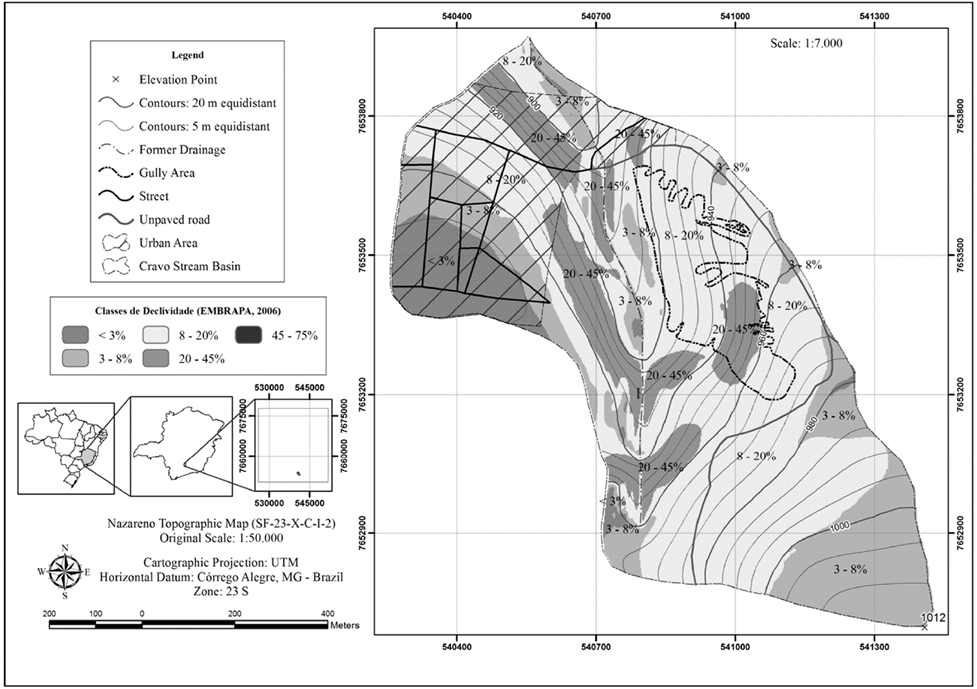
Figure 2: Slope classes map: Cravo Stream Basin, Nazareno-MG.
It has been verified that the flow of surface runoff (Fig. 3) is predominantly directed toward the northwest (NW), followed by the west (W). Observations of the Cravo Stream gully indicate that its location is maintained in these two directions, i.e., the gully is receiving the flow concentrations from the highest area and road located in the basin (northwest direction) as well as the side road (westbound). These runoff directions contribute to intense soil removal. As discussed by [15], improperly conducted soil uses, e.g., roads compacted without a proper drainage system near the head of gully’s drainage area, exacerbate the problem because they intensify the flow concentrations that are naturally converging toward the gully.

Figure 3: Flow direction map, Cravo Stream Basin, Nazareno-MG.
Considering that the terrain has favorable conditions for the concentration of flow, a theoretical study of the water supply based on projected rains that have a specific probability of occurring in the area was performed using ABC 6 software. Fig. 4 presents the three major land uses (obtained from field campaigns in 2013 and using ArcGIS 10.1) in the Cravo Stream gully contributing basin that were used to estimate the CN values from the values directly tabulated in the software and data used in the software for the SCS method (Table 1).
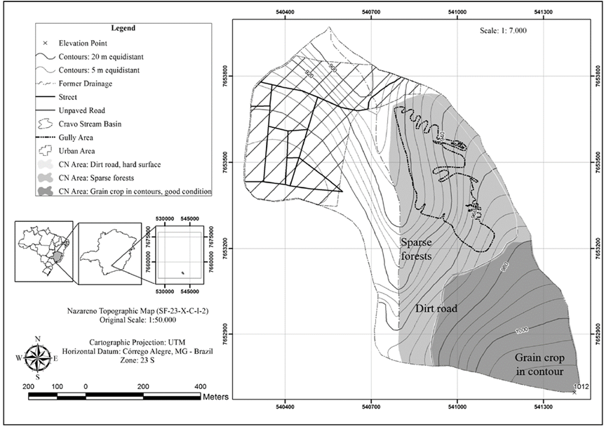
Figure 4: Map of average CN areas. Nazareno-MG.
Source: The Authors.Table 1: Estimated parameters for hydrologic simulation using the SCS method in ABC 6.

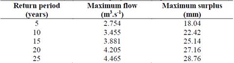
Thus, we obtained the maximum flow and runoff information based on hydrologic simulation performed in ABC 6. The return periods that were considered are commonly used for small-scale drainage projects together with consideration of other values for general evaluation and security (Table 2).
Source: The Authors.Table 2: Maximum flow rates and precipitation surplus for each return period considered - ABC 6 (Cravo Stream gully contributing basin, Nazareno-MG).
These estimates indicate that a large water load is mobilized toward the Cravo Stream gully. When combined with the steep slopes, this water load attains sufficient velocity and strength to break up the soil particles, which are already under high erodibility conditions especially in areas where the Cambisol is exposed. This soil is easily transported because it does not have sufficient cohesion to resist erosion and is characterized by a high degree of weathering with a predominance of kaolinite [14,15].
It is emphasized that the values found with ABC 6 (SCS method) were originated from approximations and have associated uncertainties. The parameters may not represent exact values in situ and the hydrologic formulations have limitations. Nonetheless, it would be necessary to reduce water load contribution and water velocity so that the water could enter drainage channels on the sides of the gully with less force. A viable proposal would be to make use of the land area less susceptible to erosion and with lower infiltration rates to slowly absorb a considerable amount of water at the head of the Cravo Stream gully (Latosols) in the early stages of runoff.
Thus, the construction of a subsurface drain or an infiltration trench at the head of the gully is proposed to reduce runoff and dampen its peak input in the gully region to minimize erosion (Fig. 5).

Figure 5: Drainage project design for the Cravo Stream gully - Nazareno-MG.
Table 3 summarizes the primary cases evaluated in our study based on the circular-type and trapezoidal-type channel parameters considered for the project proposal.
Source: The Authors.Table 3: Studies with parameter variations in the Channel software.
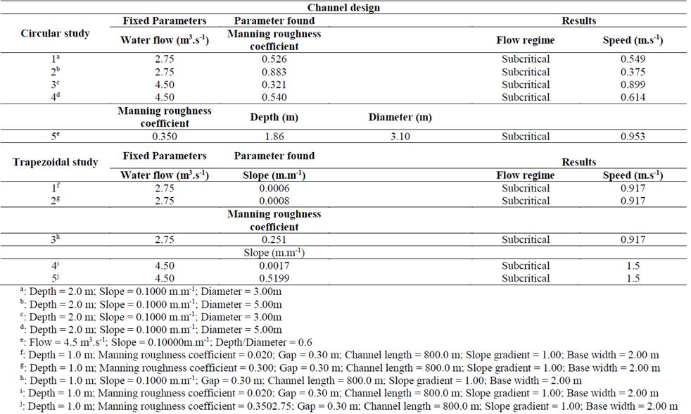
In simulations with design flows having lower or higher return times, it has been observed that a surface with a very high roughness coefficient would be necessary to maintain a non-turbulent flow in circular channels. The cases in our study with roughness coefficient closest to reaching these high values were Cases 1, 3 and 4 (Table 3); however, the flow rate of the water would greatly increase (close to 1 m.s-1) in each case, and maintaining a non-turbulent flow would only be possible by maintaining dense coverage in the channels. [20] showed that the Manning roughness coefficient can be increased with a dense cover, such as straw, which would also reduce the runoff velocity.
All simulations with circular channels were performed with an average steepness of the study area. As such, the channel configuration alteration in conjunction with slope changes was studied in addition to verifying the relationship between the channel roughness and flow rate (Table 3). There is a relationship between the channel roughness, the slope and the runoff velocity. As the channel roughness increases (covering), there are more possibilities to build a channel in a more inclined location while maintaining the same flow velocity.
For the Cravo Stream gully, for example, this alternative would avoid an excess of soil movement and landscape alteration, and this measure would be compatible with that needed for gully recovery.
Fig. 5 shows the design of an initial drainage system project for the Cravo Stream gully, in Nazareno. The main focal points of the design are the collection and infiltration of water that is directed to the north, thus reducing the water supply that would be directed to a channel (circular or trapezoidal), which would be oriented in the area in a southeast-northwest direction. To avoid the higher expenses associated with slope adjustment for the construction of the channel, it should be lined (rocks, vegetation, or combination of both) to establish an appropriate roughness coefficient, decreasing the velocity and energy with which the water encounters the soil particles, thereby reducing the removal and transport of the Cambisol (more susceptible to erosion ground). This type of initial project design is necessary because it helps in reducing the costs and effort associated with earthwork.
4. Conclusions
Simple hydrologic and hydraulic simulations with available free software are interesting tools to analyze surface runoff and compose a drainage project concept that can reduce the erosive processes by reducing the velocity of water droplets and their impact on the soil and thus aid in gully management and recovery. We recommend the elaboration of the extensions of these models for integration with GIS softwares to improve the methodology presented here.
It is possible to verify and confirm the accuracy of this usage of free softwares with in situ measurements and monitoring of rain, runoff volume and flow rate. Furthermore, we suggest more studies of native vegetation parameters, such as the vegetation’s capacity to trap sediments or its Manning roughness coefficient, to present better alternatives to cover water channels.
Macrodrainage system projects for gullies using free software could reduce losses to landowners or municipalities that do not have the financial resources for this type of work, as in much of the city of Nazareno and the Upper Rio Grande River Basin. More efficient erosion control is possible with a few but correct actions in a drainage project.
Acknowledgements
Coordination of the Superior Level Staff Improvement (CAPES) and the National Council for Scientific and Technological Development (CNPq) for financial support. CNPq Process: 141835/2015-0.
References
Referencias
Izidorio, R., Martins-Filho, M.V., Júnior, J.M., de Souza, Z.M. e Pereira, G.T., Perdas de nutrientes por erosão e sua distribuição espacial em área sob cana-de-açúcar. Engenharia Agricola. Jaboticabal. 25(3), pp. 660-670, 2005. DOI: 10.1590/S0100-69162005000300011.
Júnior, J.F.P., Cruz, J.M., Nogueira, T.C. e Rodrigues, S.C., Monitoramento de processos erosivos em parcelas experimentais no município de Uberlandia, MG. Caminhos de Geografia. Uberlandia. 10, pp. 92-108, 2009. ISSN 1678-6343.
Rodrigues, F.M., Pissavia, T.C.T. e Campos, S., Análise temporal dos processos erosivos na microbacia hidrografica do Córrego da Fazenda Glória, Taquaritinga, SP, Brasil. Revista Arvore. 35, pp. 745-750, 2011. DOI: 10.1590/S0100-67622011000400019.
Oliveira, J.F., Griebeler, N.P., Correchel, V. e da Silva, V.C., Erodibilidade e tensão crítica de cisalhamento em solos de estradas não pavimentadas. AGRIAMBI. 13, pp. 955-960, 2009. DOI: 10.1590/S1415-43662009000700019.
Enriquez, A.G., da Silva, D.P., Pruski, F.F., Griebeler, N.P. e Cecon, P.R., Erodibilidade e tensão crítica de cisalhamento no canal de drenagem de estrada rural e não pavimentada. AGRIAMBI, 19, pp. 160-165, 2015. DOI: 10.1590/1807-1929/agriambi.v19n2p160-165.
Pereira, P., Gimeìnez-Morera, A., Novara, A., Keesstra, S., Jordán, A., Masto, R.E., Brevik, E., Azorin-Molina, C. and Cerdà, A., The impact of road and railway embankments on runoff and soil erosion in eastern Spain. Hydrology and Earth System Sciences - Discussions, 12, pp. 12947-12985, 2015. DOI: 10.5194/hessd-12-12947-2015.
Poesen, J., Nachtergaele, J., Verstraeten, G. and Valentin, C., Gully erosion and environmental change: importance and research needs. Catena, 50, pp. 91-133, 2003. DOI: 10.1016/S0341-8162(02)00143-1.
Le Roux, J.J. and Sumner, P.D., Controlling gully development: comparing continuous and discontinuous gullies. Land Degradation & Development, 23, pp. 440-449, 2012. DOI: 10.1002/ldr.1083.
Prosdocimi, M., Tarolli, P. and Cerdà, A., Mulching practices for reducing soil water erosion: A review. Earth-Science Reviews, V. 161, pp. 191-203, 2016. DOI: 10.1016/j.earscirev.2016.08.006.
Rotta, C.M.S. and Zuquette, L.V., Erosion feature reclamation in urban areas: Typical unsuccessful examples from Brazil. Environmental Earth Sciences, 72(2), 21 P., 2013. DOI: 10.1007/s12665-013-2974-y.
Oliveira, C.P.M., Porto, R.L., Zahed-Filho, K. e Roberto, A.N., ABC 6, um sistema de suporte a decisões para análise de cheias em bacias complexas. In: XIII Simpósio Brasileiro de Recursos Hídricos, Associação Brasileira de Recursos Hídricos (ABRH), Belo Horizonte, 1999. 18 P.
Grupo de Pesquisa em Recursos Hídricos (GPRH). Softwares: Canal. [online]. [Access in June 22, 2016]. Available at: http://www.gprh.ufv.br/?area=softwares.
Panagos, P., Borrelli, P., Poesen, J., Ballabio, C., Lugato, E., Meusburger, K., Montanarella, L. and Alewell, C., The new assessment of soil loss by water erosion in Europe. Environmental Science & Policy, 54, pp. 438-447, 2015. DOI: 10.1016/j.envsci.2015.08.012.
Sampaio, L.F., Oliveira, M.P.P., Rodrigues, V.G.S. and Pejon, O.J., Review of soil degradation in the region of Nazareno, Minas Gerais: Brazil, in: Lollino, G., Manconi, A., Guzetti, F., Culshaw, M., Bobrowsky, P. and Luino, F., Eds. Engineering Geology for Society and Territory – Volume 5, Urban Geology, Sustainable Planning and Landscape Exploitation, Springer International Publishing. Turin, Italy, 2015, pp. 433-437, DOI: 10.1007/978-3-319-09048-1.
Ferreira, V.M., Silva, M.L.N., Curi, N., Oliveira, A.H., Silva, M.A. e Avanzi J.C., Influência antrópica e atributos de solo: Inter-relações em ambientes de voçorocas na mesorregião Campos das Vertentes, MG. Geografia, 36, pp. 209-219, 2011.
Sampaio, L.F., Oliveira, M.P.P., Rodrigues, V.G.S. and Pejon, O.J., Review of soil degradation in the region of Nazareno, Minas Gerais: Brazil.. In: Lollino et al. (eds.), Engineering Geology for Society and Territory – Vol. 5, Springer International Publishing Switzerland. 2015, pp. 433-437. DOI: 10.1007/978-3-319-09048-1_83.
Ferreira, R.R.M., Ferreira, V.M., Tavares-Filho, J. e Ralisch, R., Origem e evolução de voçorocas em cambissolos da bacia Alto Rio Grande, Minas Gerais. Proceedings of XXXI Congresso Brasileiro de Ciência do Solo, Gramado-RS, 2007, 5 P.
Dantas, A.A.A., Carvalho, L.G. e Ferreira, E., Classificação e tendências climáticas em Lavras, MG. Ciênc. Agrotec., Lavras, 31(6), pp. 1862-1866, 2007.
Instituto Brasileiro de Geografia e Estatística (IBGE). Folha Nazareno (SF-23-X-C-I-2), escala 1:50.000. Primeira Edição. Superintendência de Cartografia. 1975. [online] Available at: ftp://geoftp.ibge.gov.br/cartas_e_mapas/folhas_topograficas/editoradas/escala_50mil/nazareno26432.pdf. Acesso em: 21 de julho de 2013.
Cassol, E.A., Cantalice, J.R.B., Reichert, J.M. e Mondardo, A., Escoamento superficial e desagregação do solo em entressulcos em solo franco-argilo-arenoso com resíduos vegetais. Pesq. Agropec. Bras., Brasília, 39(7), pp.685-690, 2004.
Cómo citar
IEEE
ACM
ACS
APA
ABNT
Chicago
Harvard
MLA
Turabian
Vancouver
Descargar cita
CrossRef Cited-by
1. L. S. C. Real, S. Crestana, R. R. M. Ferreira, V. G. S. Rodrigues. (2020). Evaluation of gully development over several years using GIS and fractal analysis: a case study of the Palmital watershed, Minas Gerais (Brazil). Environmental Monitoring and Assessment, 192(7) https://doi.org/10.1007/s10661-020-08362-7.
2. A. K. M. Soares, S. Crestana, R. R. M. Ferreira, V. G. S. Rodrigues. (2024). Assessment of the impact of conservation measures by modeling soil loss in Minas Gerais, Brazil. Environmental Monitoring and Assessment, 196(4) https://doi.org/10.1007/s10661-024-12509-1.
Dimensions
PlumX
Visitas a la página del resumen del artículo
Descargas
Licencia
Derechos de autor 2017 DYNA

Esta obra está bajo una licencia internacional Creative Commons Atribución-NoComercial-SinDerivadas 4.0.
El autor o autores de un artículo aceptado para publicación en cualquiera de las revistas editadas por la facultad de Minas cederán la totalidad de los derechos patrimoniales a la Universidad Nacional de Colombia de manera gratuita, dentro de los cuáles se incluyen: el derecho a editar, publicar, reproducir y distribuir tanto en medios impresos como digitales, además de incluir en artículo en índices internacionales y/o bases de datos, de igual manera, se faculta a la editorial para utilizar las imágenes, tablas y/o cualquier material gráfico presentado en el artículo para el diseño de carátulas o posters de la misma revista.


