


Published
GEOPHYSICAL EVIDENCE FOR AN IMPACT CRATER IN VICHADA, NORTHWESTERN SOUTH AMERICA AND ITS ECONOMIC POTENTIAL
GEOPHYSICAL EVIDENCE FOR AN IMPACT CRATER IN VICHADA, NORTHWESTERN SOUTH AMERICA AND ITS ECONOMIC POTENTIAL
Orlando Hernández1,2, Ralph R.B. von Frese2,3, Khurama, S.1,4
1 Dept. of Geosciences, Universidad Nacional de Colombia, Bogotá, D.C., Colombia ohernandezp@unal.edu.co
2 School of Earth Sciences & Byrd Polar Research Center, The Ohio State University, Columbus, OH 43210, USA
3 Laboratory for Space Geodesy & Remote Sensing Research, The Ohio State University, Columbus, OH43210, USA
4 Ingeominas. Bogotá, D.C., Colombia
Manuscript received: 11/06/2009 Accepted for publication: 20/11/2009
ABSTRACT
A prominent positive free-air gravity anomaly mapped over a roughly 50-km diameter basin is consistent with a mascon centered on (4°30"N, -69°15"W) in the Vichada Department, Colombia, South America. The inferred impact crater is nearly one third the size of the Chicxulub Crater. It must have formed recently, in the last 30 m.a because it controls the path of the Vichada River. The impact crater structure has been partially eroded and is almost completely covered by vegetation. No antipodal relationship has been established. The proposed impact appears to have contributed to the development of mineral deposits of economic interest. The impact shock waves extensively thinned and disrupted the Precambrian cratonic crust. A thick sedimentary cover, dense vegetation and erosional processes greatly limits direct geological testing of the inferred impact basin. Ground follow up gravity and magnetic surveys are recommended for confirming the regional free air gravity anomalies.
Key words: Impact crater, Vichada, Gravity, Magnetic.
RESUMEN
Una anomalía gravimétrica positiva de aire libre ha sido mapeada sobre una Cuenca de aproximadamente 50 km de diámetro, la cual coincide con la ubicación de una concentración de masa o MASCON, centrada en las coordenadas 4°30"N, -69°15` en el Departamento de Vichada, Colombia, Suramérica. La estructura de impacto de meteorito inferida corresponde a una tercera parte del tamaño de la estructura de impacto de Chicxulub. Esta estructura debe haberse formado en los últimos 30 m.a. debido a que controla la trayectoria del río. La estructura de impacto ha sido parcialmente erosionada y está casi completamente cubierta por una densa vegetación. No se han establecido relaciones anti polares. El impacto de meteorito propuesto pudo haber contribuido al desarrollo de depósitos minerales de interés económico. Las ondas de choque han adelgazado y distorsionado intensamente la corteza cratónica precámbrica. Una delgada secuencia sedimentaria, la vegetación densa y los procesos erosivos limitan considerablemente la verificación de la estructura mediante geología de superficie. Se recomienda realizar estudios de gravimetría y magnetometría terrestre para confirmar la ocurrencia de las anomalías gravimétricas regionales asociadas a la estructura.
Palabras clave: estructura de impacto, Vichada, Gravimetría, Magnetometría.
Introduction
The Vichada structure is located in the southern region of the Vichada Department, Colombia (4°30'N - 69°15'W), having a multiple ring structure with inner and outer ring diameters of 30 km and 50 km, respectively (figure 1).The Vichada structure was initially proposed by Rocca (2004) who recognized a possible large impact crater structure based on the remote sensing interpretation of color Landsat satellite images of the area, with a resolution of 200m, obtained from the NASA's John C. Stennis Space Center, USA (figure 2, Rocca, 2004). This area is part of the Vichada Plain and it is partially covered by quaternary deposits and vegetation. The central core consists of a ring about 30 Km. in diameter which surrounds a central depression of circular shape and 20 Km. in diameter. In this innermost region, there is a basin, the relief is quite smooth and it is the deepest part of the structure. The central basin is covered by dense vegetation and it is surrounded by 2 concentric rings of low hills of few meters each that have been intensively eroded. The outermost ring has 50 Km in diameter and in the South, the Vichada River flows around it in a perfect semi-circle path following the external limits of this outer ring of hills. The outer ring also controls some local drainage systems in the North and northwest. The flow ofthe rivers around these features is anomalous. The geology of the area is limited exposed and is represented by tertiary sandstone and claystone formations, covered by quaternary deposits (De la Espriella et al., 1990). The crystalline basement is formed by the Pre-cambrian Parguazan granite, outcropping along the Vichada and Orinoco rivers far away to the east of the studied area. The hidden geology includes metasedimentary and granitic rocks with an extensive sedimentary cover. The sedimentary units are composed by a heterogeneous sequence of conglomerates, sandstones and clays. They are dated Oligocene to Pliocene and they cover the Precambrian crystalline basement rocks. The structure was forwarded modeled for gravity and magnetic signatures that were compared with observed gravity and magnetic profiles (Khurama, 2007). This forward modeling eliminates the possibility of the presence of other geological causative bodies such as igneous intrusions, Maars, Diatremes or sedimentary structures, leaving the model of an impact crater as the most probable phenomenon that could generate the circular structure. Rocca (2004) suggested that the Vichada structure is probably older than 30 Ma. There is not additional available geochronological data to support the age of the structure.


The Vichada flat plain is located east of the Andean mountains. This part of northwestern South America has poorly been studied for crustal properties. The lack of airborne and terrestrial geophysical data and poorly known geology has been recognized in global databases such as the CRUST 2.0 model (Bassin et al., 2000) that assignees crustal thickness to the Guiana Craton taken data from other cratonic areas of the world. Extending the hunt for impact basins into South America is problematic because the jungle and quaternary deposits cover more than 95% the crust and the remote environment greatly limits field studies. Thus, our understanding of the geological and geophysical properties of the crust is very poor. However, EGM96 spherical harmonic Earth Gravity Model to degree and order 360, EGM96 data (Lemoine, et al., 1998) provides important details of the gravity field that can further our understanding of the crustal features.
Spectral correlation theory was used to analyze the co-registered FAGA and TGE for their anomaly correlations. Specifically, the Fourier transforms T and F of TGE and FAGA, respectively, were used to obtain their correlation spectrum (von Frese et al., 1997a, Kim, et al., 2000) given by
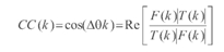
where CC(k) is the correlation coefficient between the kth wavenumber components F(k) and T(k), and denotes taking the real parts of the wavenumber components. Usually, CC(k) is evaluated from the cosine of the phase difference between the two kth wavenumber components. Using the correlation spectrum between FAGA and TGE, spectral correlation filters were designed to extract terrain-correlated free-air gravity signals. Those wavenumber components showing intermediate to high positive (CCp(k)>0.3) and negative (CCn(k) < 0.3) correlations were identified. The cut off values for the correlation filter were determined to minimize correlative features between the terrain-decorrelated free air and compensating terrain gravity components. Inversely transforming positively and negatively correlated free-air wavenumber components according to the selected cut off values yielded the terrain-correlated free air gravity anomalies (TCFAGA) in Figure 3.a. The residual ter-rain-decorrelated free-air gravity anomalies (TDFAGA)in Figure 3.bwere calculated by subtracting TCFAGA from FAGA, so that

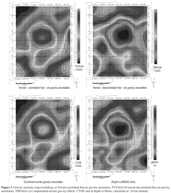
TCFAGA are explained by anomalies associated with the topography while TDFAGA include the gravity effects of sources within the crust (i.e., local bodies) and the subcrust. As a result, figure 3 Shows a) the terrain correlated Free Air Gravity Anomalies (TCFAGA), b) terrain de-correlated free air gravity anomalies (TDFAGA), c) the compensated terrain gravity effects (CTGE) and d) inversely modeled depth to MOHO, respectively, calculated at 20 km from the Earth Gravity Model 1996 (Hernandez, et al., 2008) that is constrained by 30-arc minute averages of available surface gravity values and gravity estimates from orbital variations of satellites operating at altitudes generally higher than 700 km (Lemoine et al., 1998). TCFAGA and TDFAGA have been obtained by spectrally correlated Terrain gravity effects (TGE) and free air gravity anomalies (FAGA). Similarly, FCTGE and FDTGE were calculated. TCFAGA detail is particularly significant over the Vichada structure. The terrestrial EGM96 anomaly estimates in Figure 3 essentially reflect the lower order effects from gravity observations located some ± 20 km. The EGM-96 results include the prominent positive anomaly feature that overlies the Vichada Structure basin inFigures 1 and 2 centered on (4°30'N - 69°15'W) in the Vichada Plain. It consists of a circular central positive anomaly flanked by a negative ring anomaly that in isometric view looks like a Mexican sombrero.
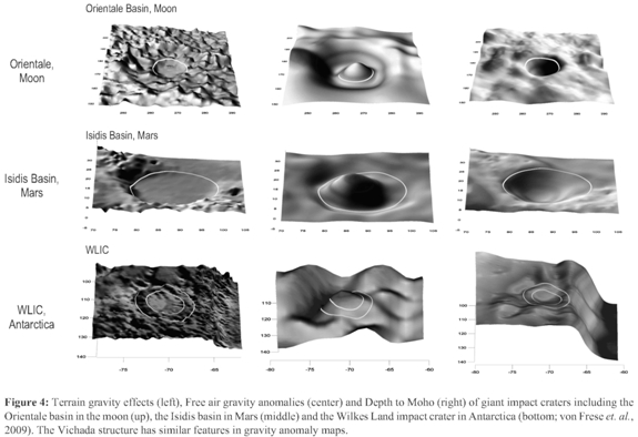
The sombrero anomaly is commonly observed over giant impact basins on the Moon and Mars, where it is attributed to the effects of uncompensated concentrations of mass produced within the crust from the impact (figure 4; von Frese et al, 2009). The central positive free-air gravity anomaly results from the subjacent concentration of enhanced mass or 'mascon' of uncompensated components of any basaltic fill in the crater and the mantle plug intruded into the crust when it recoiled from meteorite impact. The strength of the lithosphere presumably supports the mascon against mass-equilibrating isostatic forces to produce the central gravity maximum. Lithospheric strength also maintains the isostatically under-compensated thickened crust around the mantle plug to produce the flanking ringed free-air minimum.
In the sections below, we quantitatively model the crustal properties of the inferred Vichada impact crater from the EGM-96 and terrain data. We also consider the implications of the inferred impact for the development potential economic deposits.
Gravity anomaly modeling
Figure 3 provides more detailed views of the EGM-96 free-air gravity anomalies at 20-km altitude superposed on the terrain topography of the Vichada study area. Gravity anomaly estimates were derived from the EGM-96 gravity model evaluated to spherical harmonic degree and order 90 to emphasize the more robust qualities of the EGM-96 measurements. The higher frequency components, for example, are relatively poorly determined according to the model s covariance properties. And at lower altitudes, the anomaly estimates have dramatically increasing noise levels, as well as decreasing reliability due to the lack of terrestrial gravity observations (von Frese et al., 1999) and the lack of uniqueness of the gravity modeling (von Frese et al., 2005).
TCFAGA and TGE were normalized to facilitate recognizing the anomaly correlations between them (von Frese etal., 1997). To enhance the visual perception of the anomaly correlations, the following transformation was applied:
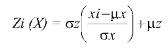
where μz and represent the values of the mean and standard deviation, respectively, of the signal X. The expression in parentheses standardizes the xi coefficients to zero mean and unit standard deviation and is dimensionless. However, the values for mean and standard deviation of of the normalized signal Z can be specified by the user to facilitate the visual analysis. Local favorability indices (Merriam and Sneath, 1966) were used to highlight the various anomaly correlations in the normalized TCFAGA and FCTGE (figure 5). Positively correlated features were mapped out by summed local favorability indexes (SLFI) obtained by:
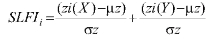
where Z(X) and Z(Y) were the normalized TCFAGA and TGE coefficients, respectively. The peak-to-peak correlations between the two data sets were mapped out by positive SLFIi (figure 5a), whereas trough-to-trough correlations were mapped out by the negative coefficients of SLFIi (figure 5b). The SLFI coefficients brought out the positively or directly correlated features, while suppressing the negatively and null correlated features between TCFAGA and TGE. To enhance the perception of inversely correlated features obtained from wavenumbers with negative correlation coefficients, the normalized and scaled datasets were subtracted cell by cell for differenced local favorability indexes (DLFI) by:

Positive features in TCFAGA which were correlative with negative TGE features (peak-to-trough) were mapped out by positive DLFI in Figure 5c, whereas negative TCFAGA that were correlative with positive TGE were mapped out by negative DLFI in Figure 5d. The DLFI coefficients emphasized the inversely correlated features, while suppressing the positively and null correlated features between TCFAGA and TGE. With an exception of figure 5b, it is clear how the SLFI and DLFI products show local favorability indices that enhance the Vichada impact structure.

The mascon gravity anomaly in Figure 6 consists of the well-defined relatively positive 26 mGal anomaly overlying the inferred impact basin. To evaluate the inferred mascon s first order crustal properties, Moho relief was determined with gravity effects that fully nullified the gravity effects of the terrain. Then, this Moho relief was adjusted to lower levels until it nullified the EGM-96 mascon free-air gravity anomaly. Thus, the mascon was interpreted underlying the basin as the uncompensated component of the mantle plug given by the difference between the two Moho levels. The modeling, although not unique, accounts for the independently observed terrain and gravity data of the study region.

The spherical coordinate gravity effects of the terrain were modeled at 20 km altitude using Gauss-Legendre quadrature integration (von Frese et al., 1981; Hernandez, 2006) and a density of 2.85 gm/cm3 for the components of the terrain. The altitude of 20 km was chosen for modeling these effects to limit local terrain density errors (Leftwich et al., 2005). Then, Moho variations were modeled from the inversion of complete Bouguer anomalies obtained by subtracting the terrain gravity effects from zero free-air anomalies. For this modeling, a horizontal density contrast of 0.4 g/cm3 was assumed between mantle and crust fully compensated the basin's crust across the Moho.
Figure 6 summarizes the modeling results on a profile along E-W for an inverse modeling using the utilities from GM-SYS. The geological model shows the inferred Moho estimates that characterize the mantle plug beneath the impact basin as being some 30-km across and 5-km thick. These spatial dimensions are probably minimal because erosion, sedimentation, and viscous relaxation of the crust have muted the topography. However, the overlying positive EGM-96 free-air anomaly suggests that the crustal model may not be completely compensated. Therefore, the inferred Moho was adjusted to obtain the equilibrium Moho with gravity effects that effectively nullify the EGM-96 free-air anomaly.
Discussion
The crustal modeling suggests that the mantle component in Figures 3d and 6 can account for the mascon of the inferred Vichada impact crater. The diameter D1 « 50 km of its central basin ring estimated from the topography is nearly one third times the 180-km central basin diameter of Chicxulub
impact crater. Large multi-ring basins of the Moon and other terrestrial planets appear to follow the  D1ring spacing rule for the diameter Dn of the nth-ring (e.g., Spudis, 2005). By this rule, the Vichada impact crater roughly intersects the Vichada River as shown in Figures 1 and 2.
This result raises the interesting possibility that meteorite-impacted crust influenced the formation of mineral and hydrocarbon deposits of economic interest in the area, as proposed for the Sudbury impact crater and associated mineral deposits in Ontario, Canada (Wilson, 1989). The most expedient and viable test of the inferred Vichada structure mascon is to explore for confirming anomalies with airborne gravity and magnetic surveys. Impacts such as Chicxulub are also known to modify crustal magnetization significantly. Satellite magnetic observations mostly characterize the thinned crust of the study region as positively magnetized consistent with the effects of post-impact igneous modifications of the crust. Clearly, modern aeromagnetic surveying can provide another important test of the crustal properties of Vichada impact crater.
Economic implications
Resource-forming processes can be linked to approximately 25% of all terrestrial impact structures world-wide, either as a direct result of the impact event or through subsequent modification of the target rocks. Meteoroid impacts are catastrophic events that release enormous amounts of energy that can heat, displace and metamorphose the target rocks instantaneously. The extreme geologic environment and processes that result from an impact event can result in the creation, or preservation of, a range of economic resources. Grieve and Masiatis (1994) predict that resource-forming processes can be linked to approximately 25% of all terrestrial impact structures, either as a direct result of the impact event or through subsequent modification of the target rocks. The Sudbury impact event was one of the largest ever recorded on the Earth, with an estimated original crater diameter in excess of200 km. The impact event is predicted to have excavated a hole in the crust 20 km deep and created a melt sheet 60 km wide and 2.5 km deep (Masaitis, 1989). During the early stages of cooling of this melt, the Sudbury Igneous Complex, sulphide-rich liquids exsolved and settled to the bottom of the sheet to produce the 50 or more known Ni, Cu and PGE deposits of the Sudbury Camp. Extreme shock pressures, in excess of 35 GPa, near the point of impact may create impact diamonds by the direct modification of the atomic structure of graphite or coal within the target rocks. While rich concentrations of diamond may be found in impact melt rocks produced from a graphite-bearing target rock, eg 1.5 Mt at 9.13 carats/t at Zapadnaja, Ukraine (Grieve and Masaitis, 1994), these solely consist of fine-grained aggregates suitable only for industrial purposes. The most significant example of a progenetic relationship of an economic resource with an impact crater is between the Witwatersrand goldfields and the Vredefort structure where many of the mining districts are likely to have been preserved from erosion by the downwards displacement by several kilometres of the target rocks within the structure surrounding the VredefortDome. Hydrocarbon accumulations are one of most common economic resources associated with impact craters, with almost half of the twenty-six craters formed in North American basins associated with commercially exploited fields. A number of geologic effects resulting from a meteorite impact directly affect the ability of the target rocks to generate and accumulate hydrocarbons. The most important effect is the creation of thick layers of brecciated and faulted rock, both within and outside the crater, that can form ideal reservoir rocks that can produce at high rates of flow. These can then be "capped" by a layer of fine grained fallout that can produce a natural seal for the reservoir. Structural traps may also be produced faulting in the collapsed terraces of a complex crater. Heat transferred into the ground by the impact and stored in the deformed rocks of the central uplift and the surrounding melt and breccia can interact with ground or meteoric waters to produce local hydrothermal systems. For example, fluid inclusion studies of the 24 km diameter Haughton crater in Canada suggest that a hydrothermal system with temperatures between 200°C and 600°C existed for several thousand years following the impact event. Except for the origin of the melt, these hydrothermal systems are analogous to the convection cells set up by igneous intrusions and have the potential to remobilize metal and form epithermal deposits. Several small vein-hosted deposits have been found within, or close to, the central uplift of several impact craters, including historically mined deposits totaling 300kt grading 3% Pb, 1.5% Zn near the 55 km diameter Siljan structure in Sweden (Grieve and Masiatis, 1994). Very large impact craters, which can maintain hydrothermal activity for around a million years, can produce their own exhalative systems in the overlying sedimentary rocks. Two such deposits, with a combined resource of over 6Mt @ 4.4% Zn, 1.4% Cu and 1.2% Pb, are formed in the sedimentary rocks of Sudbury Basin that overlie the thick sequence of impact breccia and melt. Perhaps more important than the transient hydrothermal cells driven by heat generated by the impact event, deformation of the target rocks will have a long term effect on the local hydrogeology around the impactsite. The same deformed rocks that form hydrocarbon reservoirs can also be excellent aquifers. Craters can also naturally fill with water to form large lakes in wet climates. When the mouth of the river draining from the 70 km diameter Manicouagan structure was dammed it produced a reservoir with a capacity of approximately 142 trillion litres of water. Outflow from this reservoir powers two hydroelectric power stations with a combined capacity of 2500 MW per annum. The impact crater itself can form a third order basin where the deposition of sediments may be greatly different from the surrounding area. If a crater-lake is formed in a dry climate, this can provide an excellent location the formation of thick evaporite deposits. Massive oil shale deposits are found within several craters in the former USSR, containing a potential resource of close to a billion barrels of oil. The Vichada structure can be one of the seven hidden impact crater structures that may be for each known outcropping impact craters that have generated associated mineral deposits.
Conclusions
The occurrence of an impact in the Vichada Plain, in northwestern South America is consistent with the regionally disrupted and thinned crust of the Vichada structure which includes a local 50km diameter depression beneath a well-defined EGM-96 free-air gravity maximum. The crater s terrain gravity effects accommodate an underlying roughly 30-km wide, 5-km thick mantle plug produced by crustal rebound from meteorite impact. However, the inferred mascon signal in the EGM-96 gravity data suggests that no more than about 70% ofthe mantle plug s mass may be isostatically compensated at the Moho.
The crustal ring structure of the Vichada impact crater intersects the Vichada river thus the impact pre-dated and influenced the development of the Vichada river and the morphological features around its inner and outer rings. The impact scenario also helps explain the crustal thinning on the studied area. Impact craters have generally been poorly regarded as targets or economic resources despite many global examples confirming their prospectivity. The greatest chance of exploration success lies in targeting craters formed in sedimentary basins for hydrocarbons; almost 50% of such structures in North America are associated with oil or gas reserves.
In the quest to meet the world s growing energy needs, an understanding of the role of hydrocarbons in meteorite impact structures may become increasingly important. This can only happen with a clearer understanding of impact structures in general and the conditions necessary to form petroleum systems within them. Identifying impact structures that meet these conditions is difficult, but the results of such efforts hold the possibility of significant economic returns.
The Vichada impact crater is supported from Landsat-TM images and interpreted EGM-96 data. This 50km-diameter impact crater is the biggest in South America. This structure is an interesting prospect for mineral and/or hydrocarbon exploration. It has a multiple ring structure covered by a sedimentary sequence of varying thickness from 200m to 1600m. The Vichada Impact crater affected rocks from the Precambrian Guiana granitic craton and tertiary sedimentary units. A combined EM and Magnetic airborne survey is recommended to resolve additional crustal and basin properties and evaluate its economic potential
Acknowledgements
Elements of this research were produced with support from the Geophysical Group at The Universidad Nacional de Colombia, Fulbright Commission, Anglogold Ashanti and Colfuturo.
References
Bassin, C., Laske, G., Masters, G. 2000, The Current Limits of Resolution for Surface Wave Tomography in North America, EOS Trans AGU, 81, F897.
De la Espriella, R., Flórez, R., Galvis, J., González, C.F., Marino, J. & Pinto, H. 1990. Geología Regional del Norte de la Comisaría del Vichada. Geología Colombiana, (17), 93-106.
Grieve, R.A.F. and Masaitis, V.L. 1994. The economic potential of terrestrial impact craters: Internat. Geol. Rev., 36, 105-151.
Hernandez, O. 2006 Tectonic analysis of northwestern South America from integrated Satellite, airborne and surface potential field anomalies, PhD dissertation, Shool of Earth Sciences, The Ohio State University, pp 198.
Hernández O., von Frese R., Khurama S. 2007. Geophysical Evidence of an Impact Crater in Northwestern South America", 2007Joint assembly AGU, Acapulco. may 2007
Khurama, S., 2007 Caracterizacion geológica y geofísica de la estructura del Rio Vichada, Inspeccion de Palmarito, Departamento de Vichada, MSc thesis, Geosciences Department, Universidad Nacional de Colombia, pp 164.
Grieve, R.A.F. and Masaitis, V.L. 1994. The economic potential of terrestrial impact craters: Internat. Geol. Rev., 36, 105-151.
Kim, J.W. von Frese, R.R.B., Rae, K.H. 2000. Crustal modeling from spectrally correlated free-air and terrain gravity data A case study of Ohio. Geophysics, 65, 4, 1057-1069.
Leftwich, T.E. von Frese, R.R.B., Potts, L.V., Kim, H.R. Roman, D.R., Taylor, P.T., Barton, M. 2005, Crustal modeling of the North Atlantic from spectrally correlated free-air and terrain gravity, J. Geodynamics, 40 (2005) 23-50.
Lemoine, F.G., Chinn, D.S., Cox, S.M., Factor, J.K. Kenyon, S.C. , Klosko, S.M., Luthcke, S.B., Olson, T.R., Pavlis, E.C., Pavlis, N.K., Rapp, R.H., Smith, W.H.F., Sandwell, D.T. 1994, Bathymetric prediction from dense satellite altimetry and sparse shipboard bathymetry. J. Geoph. res, 99, 21803-21824.
Masaitis, V.L., 1989. The economic geology of impact craters: Internat. Geol. Rev., 31, 922-933.
Merriam, D. F. and Sneath, P. H. A. 1966, Quantitative comparison of contour maps: J. Geophysical Research, 7, 1105-1115
Rocca, M.C.L. 2004 Rio Vichada: a possible 50 km wide impact structure in Colombia, South America, 67th annual meteoritical Society Meeting 2004.
Spudis, P.D., 2005, The Geology of Multi-Ring Impact Basins, Cambridge University Press, New York, NY, 277 p.
Von Frese, R.R.B, Hinze, W.J., Braile, L.W., Luca A.J. 1981, Spherical earth gravity and magnetic anomaly modeling by Gauss Legendre quadrature integration,, J. Geophys., 49, 234-242.
Von Frese, R.R.B., Jones, M., Kim, J.W., Kim, J.H. 1997, Analysis of anomaly correlations, Geophysics, 62, 1, 342-351.
Von Frese, R. R .B., Kim, H. R., Tan, L., Kim, J. W., Taylor, P. T., Purucker, M. E., Alsdorf, D. E. and Raymond, C. A. 1999. Satellite Magnetic Anomalies of the Antarctic crust. Annali de Geofísica, 42, 2, 309-326.
Von Frese, R. R. B., L. V. Potts, S. B. Wells, T. E. Leftwich, H. R. Kim, J. W. Kim, A. V. Golynsky, O. Hernandez, and L. R. Gaya-Pique', 2009. GRACE gravity evidence for an impact basin in Wilkes Land, Antarctica, Geochem. Geophys. Geosyst., 10, Q02014, doi:10.1029/2008GC002149.
Wilson, M. 1989, Igneous petrology, Winchester, Unwyn Hyman, 466 pp.
How to Cite
APA
ACM
ACS
ABNT
Chicago
Harvard
IEEE
MLA
Turabian
Vancouver
Download Citation
Article abstract page views
Downloads
License
Earth Sciences Research Journal holds a Creative Commons Attribution license.
You are free to:
Share — copy and redistribute the material in any medium or format
Adapt — remix, transform, and build upon the material for any purpose, even commercially.
The licensor cannot revoke these freedoms as long as you follow the license terms.
The Earth Sciences Research Journal is the copyright holder for these license attributes.


