Published
Sand dunes of the Gaza Strip (southwestern Palestine): morphology, textural characteristics and associated environmental impacts
DOI:
https://doi.org/10.15446/esrj.v18n2.37238Keywords:
Beach dunes, desert dunes, grain size distribution, Gaza Strip, Palestine (en)Dunas de playa, dunas de desierto, distribución del tamaño de grano, Franja de Gaza, Palestina (es)
Sand dunes are wide spread in the Gaza Strip and are present in its northern, central and southern regions. Thirty sand samples were collected at seven locations along the middle region of the Strip. The coordinates for each sampling site were positioned using GPS and processed with ArcGIS software.
Mechanical and chemical properties were examined to determine the textural characteristics and carbonate contents of the dune sands. The mean grain size is fine to medium, and the sands range from moderate- to well-sorting. The skewness is fine to very fine, and the kurtosis ranges from mesokurtic to very leptokurtic. Additionally, the results show that the carbonate content ranges from 1.5% to 5%.
The high permeability, good porosity, and low carbonate content of the sand dunes in the Gaza Strip have led to more groundwater pollution via leachates percolating from the solid waste landfills and basins from wastewater treatments constructed above the sand dunes. Sand quarries have also changed the natural landscape of the Gaza Strip. These quarries were excavated randomly, used for a short period and then disused. This random and unregulated excavation has led to the destruction of natural habitats for flora and fauna.
https://doi.org/10.15446/esrj.v18n2.37238
Sand dunes of the Gaza Strip (southwestern Palestine): morphology, textural characteristics and associated environmental impacts
Khalid F. Ubeid1, Alhasan S. Albatta2
1 Department of Geology, Faculty of Science, Al Azhar University - Gaza, P.O. Box 1277, Gaza, Palestine. Email: k.ubeid@alazhar.edu.ps
2 Department of Coastal and Marine Environment, General Directorate of Environmental Resources,
Palestinian Environment Quality Authority "EQA" - Gaza. Email: Geologist-hasan@hotmail.com
Record
Manuscript received: 23/02/2013 Accepted for publication: 16/07/2014
ABSTRACT
Sand dunes are wide spread in the Gaza Strip and are present in its northern, central and southern regions. Thirty sand samples were collected at seven locations along the middle region of the Strip. The coordinates for each sampling site were positioned using GPS and processed with ArcGIS software.
Mechanical and chemical properties were examined to determine the textural characteristics and carbonate contents of the dune sands. The mean grain size is fine to medium, and the sands range from moderate- to well-sorting. The skewness is fine to very fine, and the kurtosis ranges from mesokurtic to very leptokurtic. Additionally, the results show that the carbonate content ranges from 1.5% to 5%.
The high permeability, good porosity, and low carbonate content of the sand dunes in the Gaza Strip have led to more groundwater pollution via leachates percolating from the solid waste landfills and basins from wastewater treatments constructed above the sand dunes. Sand quarries have also changed the natural landscape of the Gaza Strip. These quarries were excavated randomly, used for a short period and then disused. This random and unregulated excavation has led to the destruction of natural habitats for flora and fauna.
Key words: Beach dunes, desert dunes, grain size distribution, Gaza Strip, Palestine.
RESUMEN
Las dunas de arena se extienden ampliamente en la Franja de Gaza y hacen presencia en las regiones del norte, centro y sur. Para este trabajo se recolectaron treinta muestras de arena en siete puntos a lo largo de la región media de la Franja. Las coordenadas de cada muestra se marcaron con el GPS y se procesaron con el programa ArcGIS. Se examinaron las propiedades químicas y mecánicas para determinar las características de textura y los contenidos de carbonato de las dunas de arena. El tamaño del grano está entre fino y medio y las arenas oscilan entre moderadas y bien definidas. La asimetría estadística va desde fina hasta muy fina y la variedad de la curtosis se ubica entre mesocúrtica y muy leptocúrtica. Adicionalmente, los resultados muestran que los rangos de contenido de carbonato están entre 1,5 % y 5 %. La alta permeabilidad, la buena porosidad y el bajo contenido de carbonato en las dunas de arena de la Franja de Gaza han permitido una mayor contaminación a través de lixiviados que se filtran desde vertederos de desechos sólidos y desde estaciones de tratamiento de aguas residuales construidas sobre las dunas de arena. Las canteras de arena, además, han cambiado el paisaje natural de la Franja de Gaza. Estas canteras fueron excavadas de manera aleatoria, utilizadas por un tiempo corto y luego cayeron en desuso. Estas excavaciones aleatorias y sin regulación han llevado a la destrucción de hábitats naturales de flora y fauna.
Palabras clave: Dunas de playa, dunas de desierto, distribución del tamaño de grano, Franja de Gaza, Palestina.
Introduction
Sand dunes cover vast land areas and are primarily located in arid regions. Sand dunes are concentrated in Africa, Australia and Asia, where approximately half of the sand dunes have stable, fixed configurations. Most of the currently fixed dunes were active during the last glacial maximum (e.g., Hesse et al., 2003; Fitzsimmons et al., 2007; Stone & Thomas, 2008; Ashkenazy et al., 2012) when the weather was colder and drier, and air turbulence was strong (e.g., Harrison et al., 2001; Lunt & Valdes, 2001; 2002; Duller & Augustinus 2006).
In Palestine, sand dunes cover an area of approximately 1,600 km2; approximately 81% of the area (1,300 km2) is located in northwestern Negev, and the remaining area is primarily located in the southern coastal plain. The northwestern Negev dunes are older than those on the coastal plain, where they invaded the area more than 15 thousands years ago. The southern coastal plain dunes are younger, approximately 100 - 1,500 years old (Goring-Morris & Goldberg, 1990; Magaritz & Enzel, 1990; Rendell et al., 1993; Tsaor et al., 2004; Singhvi & Porat, 2008; Tsaor, 2009). In the Gaza Strip, sand dunes overlay the Gaza Formation, which consists of alternations of calcareous sandstones and reddish-brown, fine-grained deposits along the middle region of the Gaza Strip between the Coastal ridge and Al Montar ridge. In addition, the sand dunes cover the beach along the western margin of the Strip. The western and middle Gaza Strip sand dunes stabilized at the end of the previous century when land use drastically changed. Stabilization of the Gaza Strip sand dunes contains considerable vegetation coverage, and architectural activities occur in the middle part of the Strip. These dunes stabilized rapidly due to the low wind power in Palestine (Tsaor, 2009).
The aim of this study was to examine the sand dunes in the Gaza Strip, specifically the morphology, textural parameters, and anthropogenic environmental impacts associated with these dunes.
Geography and geology of the Gaza Strip
The Gaza Strip is located in southwestern Palestine at the southeastern coast of the Mediterranean Sea, between 34o 2' east and 31o 45' north (Fig. 1). The Strip covers an area of approximately 365 km2, has a length of 45 km along the coastal zone, and its width ranges from 5 to 8 km in the central and northern regions to a maximum of 12 km in the south. The Gaza Strip is located in the transitional zone between a temperate Mediterranean climate in the west and north and the arid climate of the Sinai Peninsula on the east and south. The temperature gradually changes throughout the year, reaches its maximum during the summer in August and its minimum in January during the winter. The average monthly maximum temperature ranges between 17.6 Co for January and 29.4 Co for August. The average monthly minimum temperature for January is approximately 9.6 Co and 22.7 Co for August. The mean annual rainfall is 335 mm per year, and the average annual evaporation is 1300 mm.
The topography of the Gaza Strip is defined by three ridges (locally termed kurkar ridges), depressions, dry streambeds and shifting sand dunes (Fig. 1). The ridges and depressions generally extend in the NE-SW direction parallel to the coastline. The surface elevation ranges from mean sea level to approximately 110 m above mean sea level. The depressions, which contain alluvial deposits, are approximately 20 - 40 m above mean sea level.
In terms of stratigraphy, these ridges belong to the Kurkar Group (Bartov et al., 1981). This group is of a Pliocene-Pleistocene age, and within this group, three formations can be distinguished: Ahuzam Fm, Pleshet Fm, and Gaza Fm (Bartov & Arkin, 1980; Frechen et al., 2004; Galili et al., 2007; Ubeid, 2010; 2011b). The kurkar ridges, which belong to the Gaza Fm, consist of calcareous sandstones (locally termed kurkar) alternated with brown-reddish, fine-grained deposits (locally termed hamra) (Horowitz, 1975; Abed & Al Weshahy, 1999; Frechen et al., 2004; Ubeid, 2010; 2011b). In the southern part of the Gaza Strip, these features tend to be covered by sand dunes. The soil in the Gaza Strip is primarily composed of three types: sandy soil, clayey soil, and loess soil (Ubeid, 2011b; 2013). The sandy soil is found along the coastline and middle parts of the Gaza Strip in the form of sand dunes. The clayey soil is found along the northeastern part of the Gaza Strip. The loess soil is found around the Wadis area.
Materials and methods
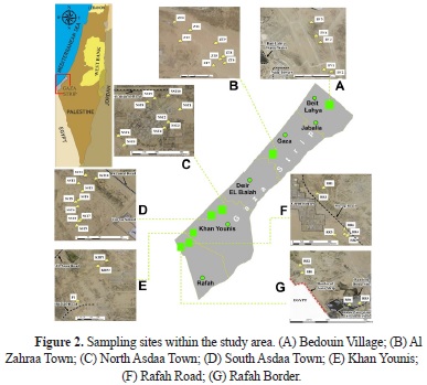
The dune field was first studied using aerial photographs and Landsat images. The sand dunes were mapped from orthophotos at a scale of 1:5000 in a GIS program and validated with field surveys. Field observations were noted and documented using field photographs. Seven localities, characterized by the presence of a dune field were selected for study, which from north to south, are the following: Bedouin Village (BV), Al Zahraa Town (ZT), North Asdaa Town (NST), South Asdaa Town (SST), Khan Younis (KHP), Rafah Road (RR), and Rafah Border (RB) (Fig. 2). At each location, the length, width and height of the dunes were measured using meter tape, and the slope of the dunes was measured in both the lee and stoss directions. The coordinates for each location were recorded using portable GPS (Table 1). The sand flow direction was determined from ripple marks and dunes using a Brunton compass.
Thirty samples were collected from the crest, lee and stoss sides of the dunes for sedimentological analysis. Samples were taken during the spring season (May-June 2012).
Approximately 100 g of each sample were used to determine the grain size. The grain size distribution was obtained using the sieve analysis method. The data were processed using GRADISTAT software following Blott and Pye (2001) to determine the grain size parameters. In this software, linear interpolation was used to calculate the statistical parameters as per Folk and Ward (1957). The software also provides a physical description of the textural group that the sample belongs to and the sediment type, which are named according to Folk (1954). The total calcium carbonate content was measured using volumetric calcimetry. The coordinates of each sampling location were integrated onto a digital map using ArcGIS software.
Results
Dune morphology and field relations
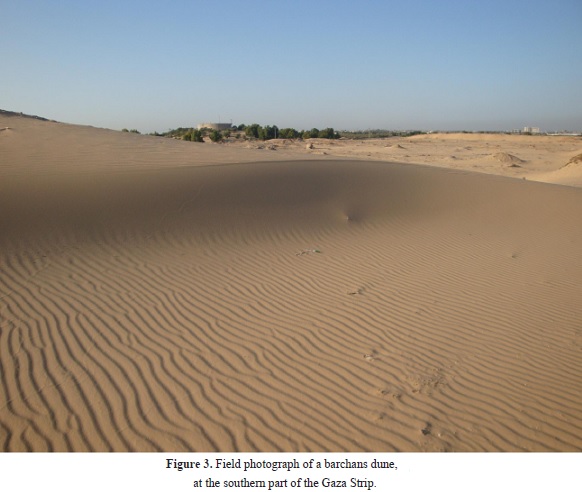
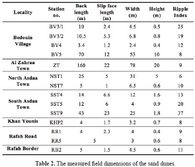
During the fieldwork, it was observed that the dunes were of the barchans type (Fig. 3). The dunes had a low-density distribution with tens of meters between dunes. Table 2 presents a summary of the dimensions of the dunes, and Figure 4 shows the morphology of the dunes in the studied area. Dunes differ in their sizes. Smaller dunes (Fig. 4A) had heights ranging from 0.4 m to 1.6 m and widths ranging from 2.4 m to 12 m, whereas relatively larger dunes (Fig. 4B) ranged in height from 1.8 m to 20 m and in width from 25 m to 78 m. There is a direct relationship between the length and width of the dunes and between their length and height (Fig. 5). The relationship between dune length and width is stronger because the fit line of the curve passes through the original point, which suggests that the wind effects that transport the sand were uniform throughout the dunes. The curves also show that the smaller dunes are closer to the line of fit; increased size may lead to some deformation in shape.
The size distributions of the dunes are random and not dependent on their location. It was observed that architectural activities, in addition to sand supplements and wind directions, affected the size and distribution of the dunes. The larger dunes were observed in open areas with low relief and were far from buildings or foundations. Additionally, the larger dunes were found at localities where the coastal ridge height was at the minimum, such as in the middle and southern parts of the Gaza Strip; these locations experienced maximum wind speeds. Additionally, sand excavation at the sand quarries affected the size of the dunes: the creation of large, flat areas in the quarries allowed sand to move easily through these areas.
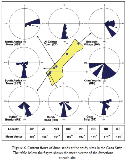
The wind direction was SSE in most locations, except in the northernmost location (Bedouin Village) and in the southern part (North Asdaa Town), where the wind direction was EES (due to open areas with a low relief at these locations, Fig. 6). The rose diagrams in Figure 6 show the vector mean and dominant direction data separately at all sites in the study area. It was observed that the vector means are not coincident with the maxima of each rose diagram. This could be due to the wind regime, which is affected by the topography of the different sites (Zu et al., 2008). It was observed that the differences are smaller in the southern sites than in the northern sites. Furthermore, the wind energy increases in the south due to the low relief of the coastal ridge in the west (Fig. 1).
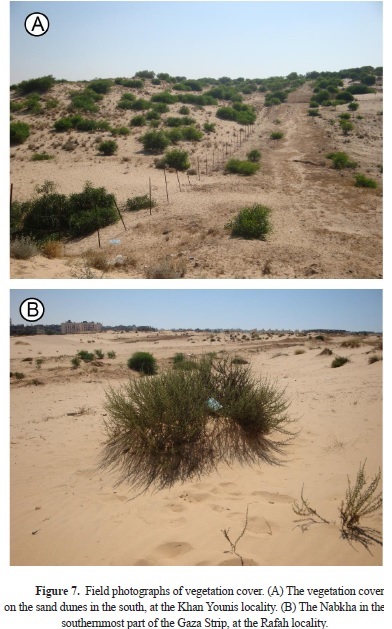
However, the density of the vegetation on the sand dunes was low to very low in the northern and middle parts of the Gaza Strip, whereas it was low to moderate in the southern part. The vegetation preserves the stability of the dunes, and the sands accumulate around the plants and form a nabkha, particularly in the south (Fig. 7).
Textural parameters
The grain size parameters of the sands from the seven sampling locations are shown in Tables 3-5. Twenty-two of the histograms that represent the mechanical composition exhibit unimodal distributions in which the modal class falls into the medium grade, whereas eight display bimodal distributions that are of fine and medium grades. The statistical grain-size parameters show that in all the studied locations, the sand dunes are primarily formed by medium sands, except in the North Asdaa Town location in the southern part of the Gaza Strip; there, the sand dunes are mostly formed by fine sands. The dune sands in all the studied locations are primarily moderately well sorted, except those at Al Zahraa Town and Rafah Road, where the dune sands are moderately sorted to well sorted. The skewness of the dune sands of the northern and middle locations is primarily very finely skewed, whereas in the southern part of the Gaza Strip (i.e., in South Asdaa Town, Khan Younis, and Rafah) the dune sands are finely skewed. The dune sands in the northern and middle parts of the Gaza Strip are primarily very leptokurtic, whereas in the middle and southern parts, they are leptokurtic to mesokurtic. The fine grain size at the North Asdaa Town is due to selectiveness of the wind, which is concentrated at the dune. The sorting values suggest that the Al Zharaa and Rafah Road dunes have been subjected to high transport by winds that control the grain size distributions within the dune system; this factor was strongly related to the extremely low height of the coastal ridge at these localities, where the effect of wind is larger.
The Gaza Strip sand dunes are rich in quartz with smaller amounts of plagioclase. Bioclasts of land snail shells were found in the middle and southern parts of the Gaza Strip (Fig. 8). The carbonate contents of the sand dunes range from 1.5% -to 5% (Table 6).
Discussion
Classification and inferred sources of sand dunes
Based on geographic location, two main categories of sand dunes can be recognized: (1) beach sand dunes and (2) desert sand dunes.
Beach sand dunes
These dunes are located along the beach at the western margin of the Gaza Strip. The sand is composed of a high percentage of a light yellow to transparent sugary quartz and approximately 1% dark-colored accessory minerals. The sand grains are characterized by medium-grained sand that is moderately well sorted (Ubeid, 2011a). The sand of this type comes from marine sediments
that were transported along the eastern shore of the Mediterranean Sea from the Nile Delta by longshore currents (Nir, 1989; Goldsmith & Golik, 1980; Goldsmith et al., 1990; Ben-Dor et al., 2006; Zviely et al., 2006; 2007; Ubeid, 2010; 2011a).
Desert sand dunes
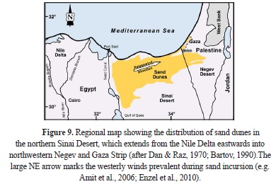
The desert sand dunes are located along the middle part of the Gaza Strip (Fig. 1). The characteristics of these dunes are outlined above (see Results) and are presented in Tables 3- 5. The characteristics of the sand reflect the aeolian sediments that were supplied from the Sinai Desert (Neev et al., 1987; Crouvi et al., 2008; Ubeied, 2011b) (Fig. 9). Sediment supply and strong winds are both crucial contributors to the dune encroachment and sand transport from the Sinai Desert to northwestern Negev and the Gaza Strip (Amit et al., 2006; Enzel et al., 2008; 2010; Roskin et al., 2011a & 2011b, 2013).
Associated environmental impacts
The anthropogenic environmental impacts associated with sand dunes in the Gaza Strip are the following:
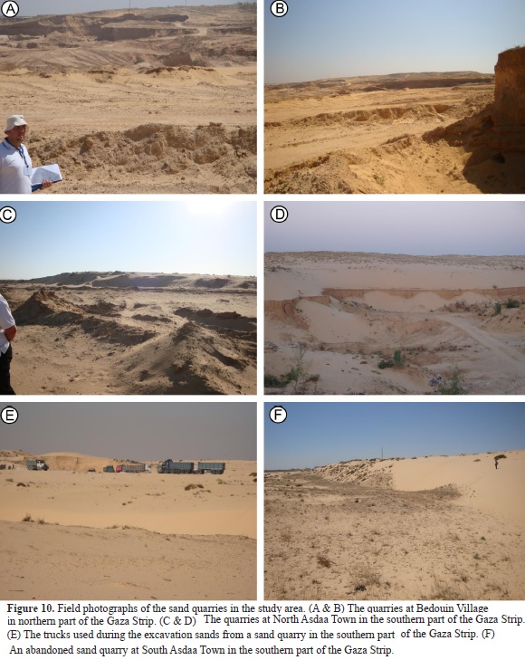
1 - Sand quarries. Randomly established sand quarries were distributed throughout most of the studied sites (Fig. 10). Sand was excavated from each quarry for a short period of time; then, workers moved the sand to another place, which left relatively large low-relief areas behind. The mineral composition of the sand dunes (i.e., primarily quartz) encourages people to excavate the sands from these quarries for commercial and industrial purposes. For example, approximately 664,759 m3 of sand was used for construction. Figure 11 shows the amount of sand excavated from the quarries in the studied sites during 2011. The excavation was performed without any plan for the future, which led to the destruction of the natural landscape and the habitat for flora and fauna in the Gaza Strip.
2 - Wastewater treatment basins. Most of these basins were established on the sand dunes (Fig. 12). The geochemical analysis results of the groundwater for the wells around the wastewater treatment basins in the Rafah location at the southernmost tip of the Gaza Strip showed that the groundwater of these wells are polluted, where most of them are not fit for drinking according to the World Health Organization (WHO) (Table 7A and 7B). Therefore, high seepage from these basins could possibly occur. The sand dunes of the Strip are characterized by high permeability and good porosity due to moderate- to well-sorted grain sand and low calcium carbonate contents. These characteristics lead to wastewater leakage into the aquifer and subsequent pollution of the groundwater. In addition, a large amount of rainfall that would otherwise be used to recharge the aquifer is lost; these basins occupy an area of at least 872 km2 above the sand dunes (Table 8).
Conclusions
In Palestine, sand dunes cover an area of approximately 1,600 km2. In the Gaza Strip, the sand dunes cover the beach area along the western margin and the middle of the Strip between the Coastal ridge and the Al Montar ridge. According to the sand dune sources, the sand dunes in the Gaza Strip can be classified as either beach sand dunes or desert sand dunes. The beach sand dunes are located along the western part of the Strip between the beach and the Coastal ridge. The origin of these dunes is the Nile Delta, from which the sands are transported by longshore currents. However, the desert sand dunes are found along the middle part between the Coastal and Al Montar ridges. They cover the northern part of the Bedouin Village, the middle region in Al Zahraa Town, and the southern areas from Khan Younis up to Rahah. The sands from these dunes originated from the Sinai Desert.
The sand dunes in the Gaza Strip have a low-density distribution and differ in size, ranging from 0.4 - 20 m in height and 2.4 - 78 m in width. Architectural activities, in addition to sand supplements and wind directions, affect their sizes and their distribution. In addition, vegetation contributes to the stability of the dunes.
The sands from the middle part of the Gaza Strip are primarily medium-grained, except in North Asdaa Town, where they are fine-grained. The sands are primarily moderately well sorted, except in Al Zahraa Town and in the southernmost part of the Strip, where the sands are moderate- to well-sorted. The skewness is very fine to fine, and the sands are very leptokurtic to mesokurtic. The carbonate content in the dune sands ranges from 1.5% -to 5%.
There are several wastewater treatment basins and solid waste landfills above the sand dunes in the Gaza Strip. These basins and landfills pollute the groundwater due to the high permeability and good porosity of the sand dunes, which are composed of fine- to medium-grained sands and are moderate- to well-sorting. The random distribution of the sand quarries, wastewater treatment basins, and solid waste landfills have destroyed the natural landscape of the Gaza Strip.
References
Abed, A. and Al Weshahy, S. (1999). Geology of Palestine. Palestinian Hydrogeological Group, Palestine, Jerusalem, 461 pp.
Amit, R., Enzel, Y. and Sharon, D. (2006). Permanent Quaternary hyperaridity in the Negev, Israel, resulting from regional tectonics blocking Mediterranean frontal systems. Geology, 34, 509-512.
Ashkenazy, Y., Yizhaq, H. and Tsoar, H. (2012). Sand dune mobility under climate change in the Kalahari and Australian deserts. Climate Changes, 112, 901-923.
Bartov, J. (1990). Geological photomap of Israel and adjacent areas. Geological Survey of Israel.
Bartov, Y. and Arkin, Y. (1980). Regional Stratigraphy of Israel. A guide to geological mapping. Geological Survey of Israel, Current Research, 38-41.
Bartov, Y., Arkin, Y., Lewy, Z. and Mimran, Y. (1981). Regional stratigraphy of Israel: A guide to geological mapping. Geological Survey of Israel, Stratigraphic Chart.
Ben-Dor, E., Levin, N., Singer, A., Karnieli, A., Braun, O. and Kidron, G.J. (2006). Quantitative mapping of the soil rubification process on sand dunes using an airborne hyperspectral sensor. Geoderma, 131, 1-21.
Blott, S.J. and Pye, K. (2001). Gradistat: a grain size distribution and statistics package for analysis of unconsolidated sediments. Earth Surface Processes and Landforms, 26, 1237-1248.
Crouvi, O., Amit, R., Enzel, Y., Porat, N. and Sandler, A. (2008). Sand dunes as amajor proximal dust source for late Pleistocene loess in the Negev desert, Israel. Quaternary Research, 70, 275-282.
Dan, J. and Raz, Z. (1970). The soil association map of Israel. Volcani institute, Bet Dagan, Israel.
Duller, G.A.T. and Augustinus, P.C. (2006). Reassessment of the record of linear dune activity in Tasmania using optical dating. Quaternary Science Reviews, 25, 2608-2618.
Enzel, Y., Amit, R., Aayan, U., Crouvi, O., Kahana, R., Ziv, B. and Sharon, D. (2008). The climatic and physiographic controls of the eastern Mediterranean over the Late Pleistocene climates in the southern Levant and its neighboring deserts. Global and Planetary Change 60, 165-192.
Enzel, Y., Amit, R., Crouvi, O. and Porat, N. (2010). Abrasion-derived sediments under intensified winds at the latest Pleistocene leading edge of the advancing Sinai-Negev erg. Quaternary Research, 74, 121-131.
Fitzsimmons, K.E., Bowler, J.M., Rhodes, E.J. and Magee, J.M. (2007). Relationships between desert dunes during the late quaternary in the lake Frome region, Strzelecki Desert, Australia. J. Quat. Sci., 22, 549-558.
Folk, R.L. and Ward, W.C. (1957). Brazos River bar: a study in the significance of grain size parameters. Journal of Sedimentary Petrology, 27, 3-26.
Folk, R.L. (1954). The distinction between grain size and mineral composition in sedimentary-rock nomenclature. Journal of Geology, 62, 344-359.
Frechen, M., Neber, A., Tsatskin, A., Boenigk, W. and Ronen, A. (2004). Chronology of Pleistocene sedimentary cycles in the Carmel Coastal Plain of Israel. Quaternary International, 121, 41-52.
Galili, E., Zviely, D., Ranon, A. and Mienis, H.K. (2007). Beach deposits of MIS 5e high sea stand as indicators for tectonic stability of the Carmel coastal plain, Israel. Quaternary Science Reviews, 26, 2544-2557.
Goldsmith, V. and Golik, A. (1980). Sediment transport model of the southeastern Mediterranean coast. Marine Geology, 37, 147-175.
Goldsmith, V., Rosen, P. and Gertner, Y. (1990). Eolian transport measurements, winds, and comparison with theoretical transport in Israeli coastal dunes, K. Nordstorm, N. Psuty, B. Carter (Editors.), Coastal Dunes - Form and Processes. Wiley, Chichester, 79-101.
Goring-Morris, A.N. and Goldberg, P. (1990). Late Quaternary dune incursions in the southern Levant: archaeology, chronology and palaeoenvironments. Quat. Int. 5, 115-137.
Harrison, S.P., Kohfeld, K.E., Roelandt, C. and Claquin, T. (2001). The role of dust in climate changes today, at the last glacial maximum and in the future, Earth Sci. Rev., 54, 43-80.
Hesse, P.P., Humphrey, G.S., Selkirk, P.M., Adamson, D.B., Nobes, D.C., Price, D.M., Schweenninger, J.L., Smith, B., Tulau, M. and Hemmings, F. (2003). Late Quaternary Aeolian dunes on the presently humid Blue Mountains, Eastern Australia. Quat. Intertropical, 108, 13-32.
Horowitz, A. (1975). The Quaternary Stratigraphy and Paleogeography of Israel. Paléorient., 3, 47-100.
Lunt, D.J. and Valdes, P.L. (2001). Dust transport to Dome C, Antarctica, at the Last Glacial Maximum and present day. Geophy. Res. Lett. 28, 295-298.
Lunt, D.J. and Valdes, P.L. (2002). Dust depositional and provenance at the Last Glacial Maximum and present day. Geophy. Res. Lett., 29, 2085.
Magaritz, M. and Enzel, Y. (1990). Standing-water deposits as indicators of Late Quaternary dune migration in the northwestern Negev, Israel. Climate Changes 16, 307-318.
Neev, D., Balker, N., and Emery, K.O. (1987). Mediterranean coast of Israel and Sinai, Holocene tectonism from geology and geophysics and archaeology. Taylor and Francis Publ., 130 pp.
Nir, Y. (1989). The seashores of the Mediterranean Sea along Israel and north Sinai: Sedimentology aspects: Ministry of Energy and Infrastructure. The Geological Survey of Israel, Jerusalem, GSI/39/Report, 88 pp.
Rendell, H.M., Yair, A. and Tsoar, H. (1993). Thermoluminescence dating of sand movement in northern Negev, Israel, K. Pye (Editor), The Dynamics and Environmental Context of Aeolian Sedimentary Systems. Geological Society, London, 69-74.
Roskin, J., Karta, I. and Blumberg, D.G. (2013). Late Holocene dune mobilization in the northwestern Negev dunefield, Israel: A response to combined anthropogenc activity and short-term intensified windiness. Quaternary International, 303, 10-23.
Roskin, J., Porat, N., Tsoar, H., Blumberg, D.G. and Zander, A.M. (2011a). Age, origin and climatic controls on vegetated linear dunes in the northwestern Negev desert (Israel). Quaternary Science Reviews, 30, 1649-1674.
Roskin, J., Tsoar, H., Porat, N. and Blumberg, D.G. (2011b). Palaeoclimate interpretation of Late Pleistocene vegetated linear dune mobilization episodes: evidence from the northwestern Negev dunefield, Israel. Quaternary Science Reviews, 30, 3364-3380.
Singhvi, A.K. and Porat, N. (2008). Impact of luminescence dating on geomorphological and palaeoclimate research in drylands. Boreas, 37, 536-558.
Stone, A.E.C. and Thomas, D.S.G. (2008). Linear dune accumulation chronologies from the southwest Kalahari, Namibia: challenges of reconstructing late Quaternary palaeoenvironments from Aeolian landforms. Quaternary Science Reviews, 27, 1667-1681.
Tsaor, H. (2009). Geomorphological process of the sand dunes of Israel as background for the active management. Abstracts, Dunes in Israel: Policy and Management. Ben-Gurion University of the Negev, Beer Sheva, Israel.
Tsaor, H., Blumberg, D.G. and Stoler, Y. (2004). Elongation and migration of sand dunes. Geomorphology, 57, 293-302.
Ubeid, K.F. (2010). Marine lithofacies and depositional zones analysis along coastal ridges in Gaza Strip, Palestine. Journal of Geography and Geology, 2, 68-76.
Ubeid, K.F. (2011a). Sand Characteristics and Beach Profiles of the Coast of Gaza Strip, Palestine. Serie Correlacion Geologica, 27, 121-132.
Ubeid, K.F. (2011b). The nature of the Pleistocene-Holocene palaeosols in the Gaza Strip, Palestine. Geologos, 17, 163-173.
Ubeid, K.F. (2013). The origin, nature and stratigraphy of palaeosols in Wadi Es-Salqa (Gaza Strip, Palestine). Serie Correlacion Geologica, 29, 63-78.
Zu, R.; Xue, X., Qiang, M., Yang, B., Qu, J. and Zhang, K. (2008). Characteristics of near-surface wind regimes in the Taklimakan Desert, China. Geomorphology, 96, 39-47.
Zviely, D., Kit, E. and Klein, M. (2007). Longshore sand transport estimates along the Mediterranean coast of Israel in the Holocene. Marine. Geology, 238, 61-73.
Zviely, D., Sivan, D., Ecker, A., Bakler, N., Rohrlich, V., Galili, E., Boaretto, E., Klein, M. and Kit, E. (2006). The Holocene evolution of Haifa Bay area, Israel, and its influence on the ancient human settlements. The Holocene, 16, 849-861.
How to Cite
APA
ACM
ACS
ABNT
Chicago
Harvard
IEEE
MLA
Turabian
Vancouver
Download Citation
CrossRef Cited-by
1. Christina Lee, Gauti Asbjörnsson, Erik Hulthén, Magnus Evertsson. (2024). The environmental impact of extraction: A holistic review of the quarry lifecycle. Cleaner Environmental Systems, 13, p.100201. https://doi.org/10.1016/j.cesys.2024.100201.
2. Khalid Fathi Ubeid. (2016). Quaternary alluvial deposits of Wadi Gaza in the middle of the Gaza Strip (Palestine): Facies, granulometric characteristics, and their paleoflow direction. Journal of African Earth Sciences, 118, p.274. https://doi.org/10.1016/j.jafrearsci.2016.03.012.
3. Sarig Gafny. (2025). Status of Decline and Conservation of Amphibians of the Middle East. , p.95. https://doi.org/10.1007/978-3-031-68985-7_4.
4. Joel Roskin. (2017). Discussion on Ubeid, K.A., 2016. Quaternary alluvial deposits of Wadi Gaza in the middle of the Gaza Strip (Palestine): Facies, granulometric characteristics, and their paleoflow direction. JAES 118: 274–283. Journal of African Earth Sciences, 134, p.803. https://doi.org/10.1016/j.jafrearsci.2016.08.009.
5. Khaled Ahmed RAMADAN, Khalid Fathi UBEİD. (2018). Measurement of Radon Exhalation Rates from Different Rock Types and Construction Materials (Gaza Strip, Palestine). Yerbilimleri/Hacettepe Üniversitesi Yerbilimleri Uygulama ve Araştırma Merkezi Dergisi, 39(3), p.195. https://doi.org/10.17824/yerbilimleri.503884.
Dimensions
PlumX
Article abstract page views
Downloads
License
Earth Sciences Research Journal holds a Creative Commons Attribution license.
You are free to:
Share — copy and redistribute the material in any medium or format
Adapt — remix, transform, and build upon the material for any purpose, even commercially.
The licensor cannot revoke these freedoms as long as you follow the license terms.
The Earth Sciences Research Journal is the copyright holder for these license attributes.


