


Published
Seismotectonic-Geologic Hazards Zoning of Iran
DOI:
https://doi.org/10.15446/esrj.v19n1.40664Keywords:
Seismotectonic, Hazards, Zoning map, Irán, Seismicity, Earthquake (en)Sismotectónica, amenazas, mapa zonal, Irán, sismicidad, terremoto. (es)
Seismotectonic-geologic hazards zoning map of Iran is drawn based on deterministic seismic hazards evaluation using the seismicity records, structural trends, tectonic settings, fault ruptures and neotectonics activities in Iran.
This map has been prepared to indicate the seismotectonic-geologic hazards of Iran. It contains the earthquake hazards parameters such as b value and Mmax for the nineteen seismotectonic provinces. Furthermore, Moho discontinuity depth, seismogenic layer depths and seismic rates for all provinces are investigated.
The majority of deformation in Iran has been concentrated in the continental crust of the country. Zagros and Alborz experience deep earthquakes that are an indication of existence of the thick-skinned tectonics.
Finally, some provinces such as Piranshahr- Borojen, East Iran, Naien- Rafsanjan and East Alborz, which include main suture zones of Iran, have faced high seismic hazards.
https://doi.org/10.15446/esrj.v19n1.40664.
SEISMOLOGY
Seismotectonic-Geologic Hazards Zoning of Iran
Mehran Arian1
1 Department of Geology, Science and Research Branch, Islamic Azad University, Tehran, Iran; mehranarian@yahoo.com.
Record
Manuscript received: 5/11/2013 Accepted for publication: 14/01/2015
ABSTRACT
Seismotectonic-geologic hazards zoning map of Iran is drawn based on deterministic seismic hazards evaluation using the seismicity records, structural trends, tectonic settings, fault ruptures and neotectonics activities in Iran.
This map has been prepared to indicate the seismotectonic-geologic hazards of Iran. It contains the earthquake hazards parameters such as b value and Mmax for the nineteen seismotectonic provinces. Furthermore, Moho discontinuity depth, seismogenic layer depths and seismic rates for all provinces are investigated.
The majority of deformation in Iran has been concentrated in the continental crust of the country. Zagros and Alborz experience deep earthquakes that are an indication of existence of the thick-skinned tectonics.
Finally, some provinces such as Piranshahr- Borojen, East Iran, Naien- Rafsanjan and East Alborz, which include main suture zones of Iran, have faced high seismic hazards.
Key words:Seismotectonic, Hazards, Zoning map, Iran, Seismicity, Earthquake
RESUMEN
Este estudio se realizó con el fin de preparar un mapa zonal de amenazas seismotectónicas y geológicas de Irán con base en la evaluación de amenazas sismícas deterministas a través de los registros sísmicos, las tendencias estructurales, las configuraciones tectónicas, las rupturas de fallas y la actividad neotectónica en Irán. Este mapa contiene los parámetros de amenaza sismológica como los valores b y Mmax para las 19 provincias sismotectónicas del país. Además, se investigó la profundidad de la Discontinuidad de Mohorovičić, las capas sismogénicas profundas y las clasificaciomes sísmicas para todas las provincias. La mayoría de la deformación de Irán está concentrada en la corteza continental del país. Las provincias de Zagros y Alborz experimentan terremotos profundos que indican la existencia de una configuración tectónica de capa gruesa. Finalmente, algunas provincias como Piranshahr-Borojen, Este de Irán, Naien-Rafsanjan y Este de Alborz, que incluyen las principales zonas de sutura de Irán, han enfrentado grandes riesgos sísmicos.
Palabras clave: Sismotectónica, amenazas, mapa zonal, Irán, sismicidad, terremoto.
INTRODUCTION
The deterministic assessment of the seismotectonic-geologic hazards of Iran involves specifying the magnitude ranges and dominant mechanism of earthquakes that might bring about destructive effects on the regions and main cities. A seismotectonic province is a homogenous statistical unit that has distinguishable time, location and magnitude ranges for expected seismic events (Arian, 2010). Each seismotectonic province has a range of seismogenic layer depths and dominant mechanism of earthquakes, as these are related to tectonic settings, neotectonics activities, Mechanical Stratigraphy and deformational models of crust. Therefore, earthquake hazard parameters can be estimated for them.
In this study, regional tectonics (Qorashi and Arian, 2011) was integrated with seismologic data to prepare the seismotectonic-geologic hazards of Iran. The main steps in this study have been summarised as follows:
-Seismic records such as archaeological, historical (Berberian and Yeats, 1999, 2001) and instrumental seismic data up to the year 2014 which have provided information on the seismic sources have been gathered from different sources.
The Seismotectonic- geologic hazards map is identified based on the physiographic-tectonic zoning map of Iran's sedimentary basins (Arian, 2013). These basins described the locations of different structural units of Iran (Fig. 1).

-Seismicity parameters were estimated for each seismotectonic province.
Materials and Methods
At the first time, Ambraseys and Melville (1982) provided Iran's historical earthquakes and, subsequently, Earthquake Catalogue of Iran was compiled by Berberian (1994). Investigation of seismicity of Iran reveals that significant destructive earthquakes are related to the primary active faults of different tectonics settings (Engdahl, et al., 2006). Iran is one of the seismically active areas of the Alpine- Himalayan orogenic belt.
Based on previous work on neotectonics regime in Iran, Zagros in south Iran is the most active zone (Arian et al., 2002 and 2003; Arian and Qorashi 2006; Arian and Hashemi, 2008; Rahimi and Arian, 2014; Arian and Aram, 2014). Then, Alborz in north Iran (Arian and Pourkermani 2004; Feizi et al., 2007; Khavari et al., 2009 and 2010; Sorbi et al., 2011; Poroohan et al., 2009 and 2013; Arian et al., 2011a and 2012; Arian and Bagha, 2012;Nouri et al,3013; Bagha et al., 2014; Moghimi et al., 2015) and Central Iran (Arian, 2010; Housini Toudeshki et al., 2011;Houseni Toudeshki and Arian, 2011; Arian et al., 2011b, c, d; Pourkermani and Arian, 2001 have been situated in the next orders.
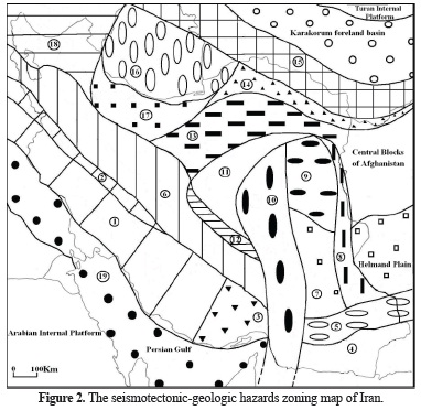
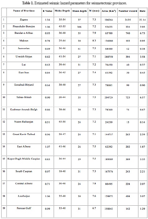
The seismotectonic provinces of Iran were formerly studied by several researchers such as Abdalian (1963), Berberian (1976), Nowroozi (1976), and Tavakoli and Ghafory-Ashtiany (1999). In this study, based on updated catalogue of significant and damaging Iranian earthquakes, a new seismotectonic -geologic hazards zoning map has been proposed. The boundaries of the provinces are established through consideration of geologic materials, seismic sources, tectonic settings, and major faults and physiographic divisions (Fig. 2).
Earthquake Hazard Parameters
Seismic hazard analysis requires an assessment of earthquake hazard parameters and the future earthquake potential in a region. Earthquake hazard parameters such as, maximum expected magnitude, Mmax, seismic rate and b value have been evaluated for each seismotectonic province of Iran by Kijko and Selevoll (1992) method. The results, which are shown in Table 1, were estimated for each seismotectonic provinces of Iran.
RESULT AND DISCUSSION
Zagros province
The dominant structural trends in Zagros province (Fig. 2) are NW-SE in north-western part and E-W in the south-eastern section. From tectonics point of view, this province contains the overthrust and simple folded belts of Zagros which has been formed in the north-eastern part of Arabian plate's passive margin. Zagros Mountains extend to East Taurus Mountains in Turkey and are called Zagros-East Taurus hinterland (Fig.1). Focal mechanisms of numerous earthquakes are reversed and thrust (Beberian, 1995) such as Naghan and Ardal (Ms=6.1, 1977) and/ or right slip in related to N-S strike slip faults such as Kazeron (SE Boshehr Ms=6.2, 2013) or Kareh Bas (Firozabad-Fars Ms=6.1, 1994, Arian et al, 2006).
Zagros province experiences low to moderate earthquakes with high frequency, short repeat time and 10-20Km focal depth. The intensity of earthquakes is in middle levels in which there are several ductile rocks (thick evaporates) in sedimentary covers such as Hormuz, Dashtak, and Gachsaran formations. Sometimes in the northern margin of this province, focal depths exceed to 70Km (Hatzfeld et al.2003) that is an indication of initial stages of thick-skinned tectonics. The most severe seismic hazards in Zagros province, including large cities such as Ilam, Ahvaz, Yasoj, Boshehr and Shiraz, are landslides in high regions of northern margins, settlements in some lowlands and coastal areas and Tsunami in southern margins.
Piranshahr- Borojen province
The dominant structural trend in Piranshahr- Borojen province (Fig. 2) is NW-SE. From tectonics point of view, this province contains the north margin of overthrust belts of Zagros formed on the north- eastern part of Arabian plate's passive margin. Focal mechanisms of several earthquakes are a right slip about main recent faults of Zagros such as Doroud (Ms=6.1, 2006).
Piranshahr- Borojen province is struck by moderate to high earthquakes with low frequency, long repeat time and 10-15Km focal depth. The intensity of earthquakes is at high levels. Sometimes, focal depths exceed to 70Km which is an indication of initial stages of thick-skinned tectonics. The most severe seismic hazards in Piranshahr- Borojen province, including cities such as Kermanshah, Khoramabad, Borojerd and Shahrekod, are landslides in high regions of northern margins, settlements in some lowlands and surface faulting.
Bandar-E Abbas province
The dominant structural trend in Bandar-e Abbas province (Fig. 2) is NE-SW. From tectonics point of view, this province contains the south-eastern part of overthrust and simple folded belts of Zagros. Focal mechanisms of several earthquakes are reversed and thrust such as Khorgo (Ms=7, 1977).
Bandar-e Abbas province is hit by moderate to high earthquakes with low frequency, short repeat time and 10-20Km focal depth. The intensity of earthquakes is in middle levels in which there are ductile rocks in sedimentary covers. The most severe seismic hazards in Bandar-e Abbas province, containing large cities such as Bandar-e Abbas, Gheshm, Bandar-e Lengeh and Hajiabad, are rapid uplifting in northern margins, settlements in some lowlands and coastal areas and Tsunami in southern margins.
Makran province
The dominant structural trend in Makran province (Fig. 2) is E-W. From tectonics point of view, this province contains the accretionary prism on trench of Oman sea subduction that extends to Pakistan (Fig. 1). Focal mechanisms of a vast number of earthquakes are reversed and thrust such as Pasni in Pakistan (Ms=8.3, 1945). Makran province experiences low to moderate earthquakes with low frequency, very long repeat time and down to 20Km focal depth. The intensity of earthquakes is in the middle to high levels. The most severe seismic hazards in Makran province, which contains large cities such as Bandar-e Chabahar and Nikshahr, are rapid uplifting in northern margins, settlements in some lowlands and coastal area and Tsunami in southern margins.
Jazmorian province
The dominant structural trend in Jazmorian province (Fig. 2) is E-W. From tectonics point of view, this province contains a fore arc basin (Jazmorian plain) which extends to Mashkel plain in Pakistan (Fig. 1). Focal mechanisms of many earthquakes are reversed and thrustand sometimes normal (in relation to bending of subducting oceanic lithosphere) such as NW Saravan with 69 Km focal depth (Ms=5.2, 2009) and SE Khash with 82 Km focal depth (Ms=7.7, 2013). Jazmorian province experiences moderate earthquakes with middle frequency, medium repeat time and down to 150Km focal depth. The intensity of earthquakes is in middle levels by very deep hypocenters.
The most important seismic hazards in the Jazmorian province, containing large cities such as Saravan and Iranshahr, are rapid uplifting and settlements in some lowlands. It should be noted that low seismicity in Makran and Jazmorian provinces is related to slow subduction rate and steeper dip of Benioff zone. Current subduction rate of oceanic crust (related to late Cretaceous) is 19 millimetres per year (Vernant et al. 2004).
Urmieh- Sirjan province
The dominant structural trend in Urmieh- Sirjan province (Fig. 2) is NW-SE. From tectonics point of view, this province contains two different units: A) Urmieh-Dokhtar magmatic arc (Fig. 1) which is the result of subduction beneath the southern active continental margin of Cimmerian plate. B) Sanandaj- Sirjan overthrust belts (Fig. 1) is formed by metamorphic rocks of the north- eastern part of Arabian plate (Alavi, 1994). Focal mechanisms of several earthquakes are reversed and thrust such as Changureh (Ms=6.4, 2002)
The Urmieh-Sirjan province is struck by low to moderate earthquakes with low frequency, medium repeat time and down to 10Km focal depth. The intensity of earthquakes is in high levels in which there are cold igneous rocks. Sometimes, focal depths exceed to 70Km that it is an indicator for initial stages of thick-skinned tectonics. The most serious seismic hazards in Urmieh- Sirjan province, which contains large cities such as Urmieh, Sirjan, Sanandaj, Hamadan, Arak, Ghom and Isfahan, are landslides in high regions of northern margins, settlements in some lowlands and surface faulting.
Lut province
The dominant structural trend in Lut province (Fig. 2) is NW-SE. From tectonics point of view, this province contains a retro arc (back arc) basin (Lut plain) which extends to Helmand plain in Pakistan (Fig. 1). Focal mechanisms of several earthquakes are reversed and thrust and/ or right slip about N-S strike slip faults such as Nayband and Nehbandan.
Lut province experiences low earthquakes with low frequency, medium repeat time and down to 10Km focal depth. The intensity of earthquakes is in high levels in which there are hot igneous rocks. The most serious seismic hazards in Lut province, which contains Lut plain, are settlements, surface faulting and volcanic hazards in southern and western parts of the plain.
East Iran province
The dominant structural trend in East Iran province (Fig. 2) is N-S. From tectonics point of view, this province contains a collision belt brought about by eastward subduction of East-Central Iran miniplate (Fig. 1) beneath Central blocks of Afghanistan. This collision belt has been formed by a dextral transpression zone. Focal mechanisms of many earthquakes are right slip in relation to N-S strike slip faulting such as Zirkuh (Berberian et al.,1999) in Qa'enat (Ms=7.2, 1997) and thrust such as west Zabol (Ms=6.2, 1993).
East Iran province is hit by moderate to high earthquakes with middle to high (on fault terminations) frequency, medium repeat time and down to 15Km focal depth. The intensity of earthquakes is at high levels. The most serious seismic hazards in East Iran province, which contains large cities such as Nehbandan, Zahedan and Khash, are landslides in high regions, settlements in some lowlands, surface faulting and dispersed volcanic hazards.
Gonabad- Birjand province
The dominant structural trend in Gonabad- Birjand province ( Fig. 2) is NW-SE. From tectonics point of view, this province contains the northern part of East-Central Iran miniplate (Fig. 1). It has been impressed by splays at the north termination of Nehbandan fault system. Focal mechanisms of numerous earthquakes are left slip in relation to W-E strike slip faulting such as Dasht-e Bayaz (Ms=7.4, 1968) and right slip in relation to NW-SE strike slip with thrust component along longitudinal faults such as South Ghaen (Ms=5.6, 2012).
Gonabad- Birjand province experiences moderate to high earthquakes with low frequency, long repeat time and down to 10Km focal depth. The intensity of earthquakes is at high levels. The most serious seismic hazards in Gonabad- Birjand province, which contains large cities such as Gonabad and Birjand, are landslides in high regions, settlements in some lowlands, and surface faulting.
Tabas-Minab province
The dominant structural trend in Tabas-Minab province (Fig. 2) is N-S. From tectonics point of view, this province contains the Tabas, Nayband, Kuh Banan, Gowk, Bam, Sazvaran and Minab fault systems. Focal mechanisms of several earthquakes are dextral strike-slip faulting with reverse component in southern part such as Bam (Ms=6.6, 2003) and reverse faulting with dextral strike slip component in northern part such as Tabas (Ms=7.4, 1978) and western part such as Zarand (Ms=6.5, 2004).
Tabas-Minab province experiences moderate to high earthquakes with low frequency, long repeat time and down to 15Km focal depth. The intensity of earthquakes is at high levels. Southward earthquake migration is index characteristic in this province. The most severe seismic hazards in Tabas-Minab province, containing large cities such as Tabas, Minab, Kerman, Bam, Jiroft and Jask, are landslides in high regions, settlements in some lowlands, surface faulting.
Kashmar- Anarak- Bafgh province
The dominant structural trend in Kashmar- Anarak- Bafgh province (Fig. 2) is NE-SW. From tectonics point of view, this province contains the northern and western part of East-Central Iran miniplate (Fig. 1). Focal mechanisms of several earthquakes are sinistral strike-slip faulting and thrusting.
Kashmar- Anarak- Bafgh province experiences low to moderate earthquakes with low frequency, medium repeat time and down to 20Km focal depth. The intensity of earthquakes is at low levels. The most serious seismic hazards in Kashmar- Anarak- Bafgh province, which contains large cities such as Kashmar, Anarak and Bafgh, are settlements in some lowlands and surface faulting.
Naien- Rafsanjan province
The dominant structural trend in Naien- Rafsanjan province (Fig. 2) is NW-SE. From tectonics point of view, this province contains the extensive part of Naien-Kerman retro arc foreland basin (Fig. 1). Focal mechanisms of several earthquakes are thrusting.
Naien- Rafsanjan province experiences low to moderate earthquakes with low frequency, medium repeat time and down to 20Km focal depth. The intensity of earthquakes is at low levels. The most serious seismic hazards in Naien- Rafsanjan province, which contains large cities such as Naien, Rafsanjan and Yazd, are settlements in some lowlands and surface faulting.
Great Kavir- Taibad province
The dominant structural trend in Great Kavir- Taibad province (Fig. 2) is NW-SE in the eastern part and NE-SW in the western part. From tectonics point of view, this province contains the Maiamay- Taibad marginal back arc basin, south- eastern part of Great Kavir- Urmieh lake foreland basin and South Great Kavir folded and thrust belt (Fig. 1). The latter case is the result of the collision between the northern part of East-Central Iran miniplate and south-eastern part of North-Central Iran miniplate.There are many salt diapirs that have been formed by tectonic forces (Arian, 2012, Asadian and Arian 2009, Pourkermani and Arian, 1997) Focal mechanisms of several earthquakes are thrusting and dextral strike-slip faulting in the eastern part and sinistral strike slip faulting and thrusting in western part such as Garmsar (Ms=5.1, 2007).
Great Kavir- Taibad province is hit by low to moderate earthquakes with low frequency, medium repeat time and down to 10Km focal depth. The intensity of earthquakes is at low levels. The most serious seismic hazards in Great Kavir- Taibad province, which contains large cities such as Semnan, Sabzehvar and Torbat-e Heydarieh, are settlements in some lowlands and surface faulting.
East Alborz province
The dominant structural trend in East Alborz province (Fig. 2) is NW-SE in the eastern part and NE-SW in the western part. From tectonics point of view, this province contains the Torbat-e Jam-Neyshabour retro arc foreland basin and East Alborz (Fig. 1) hinterland formed in a fore arc basin on the north-eastern part of Cimmerian plate. An overthrust belt with SW vergence has been formed. Focal mechanisms of several earthquakes are thrusting such as Neyshabour (Ms=7.4, 1405).
East Alborz province experiences low to moderate earthquakes with high frequency, short repeat time and down to 20Km focal depth. The intensity of earthquakes is at high levels. The most serious seismic hazards in East Alborz province, which contains large cities such as Neyshabour, Esfaraien and Shahrod, are landslides in high regions, settlements in some lowlands, surface faulting.
Kopet Dagh-Middle Caspian province
The dominant structural trend in Kopet Dagh-Middle Caspian province (Fig. 2) is NW-SE. From tectonics point of view, this province contains the Kopet Dagh hinterland (Fig. 1) or Kopet Dagh folded and thrust belt that has been formed in the passive margin of Eurasia plate. Focal mechanisms of several earthquakes are dextral strike slip faulting such as Garmkhan-e Bojnourd (Ms=6.4, 1996) and thrusting.
Dagh-Middle Caspian province experiences low to moderate earthquakes with high frequency, short repeat time and down to 20Km focal depth. Sometimes in the northern margin of South Caspian basin, focal depths exceed to 70Km which is a depiction of its subduction. The intensity of earthquakes is at low levels. The most serious seismic hazards in Dagh-Middle Caspian province, which contains large cities such as Mashhad, Ghochan and Bojnourd, are landslides in high regions, settlements in some lowlands, and surface faulting.
South Caspian province
The dominant structural trend in South Caspian province (Fig. 2) is NW-SE in the eastern part and N-S in the western part. From tectonics point of view, this province contains the South Caspian remnant oceanic basin (Berberian, 1983) and northern foreland basin of Central Alborz hinterland (Fig. 1). Focal mechanisms of several earthquakes are reversed to thrust (Jackson et al., 2002) such as Astara (Ms=6.2, 1980).
South Caspian province is struck by low to moderate earthquakes with middle frequency, short repeat time and down to 20Km focal depth. The intensity of earthquakes is at low levels. The most serious seismic hazards in South Caspian province, which contains large cities such as Gorgan, Sary and Rasht, are settlements in some lowlands and Tsunami.
Central Alborz province
The dominant structural trend in Central Alborz province (Fig. 2) is NE-SW in the eastern part and NW-SE in the western part. From tectonics point of view, this province contains the middle part of Great Kavir- Urmieh lake foreland basin and Central Alborz hinterland (Fig. 1) that has been formed in the northern active margin of the Cimmerian plate. Focal mechanisms of several earthquakes are sinistral strike-slip faulting such as Manjil (Ms=7.3, 1990) and reversed with a sinistral strike-slip component such as Boien Zahra (Ms=7.2, 1962).
Central Alborz province experiences moderate to high earthquakes with low frequency, long repeat time and down to 20Km focal depth. The intensity of earthquakes is at high levels. The most serious seismic hazards in Central Alborz province, which contains large cities such as Tehran, Ghazvin and Zanjan, are landslides in high regions, settlements in some lowlands, surface faulting and volcanic hazards around Damavand cone.
Azerbaijan province
The dominant structural trend in Azerbaijan province (Fig. 2) is NW-SE. From tectonics point of view, this province contains the north-western part of Great Kavir- Urmieh lake foreland basin and West Alborz - lesser Caucasus hinterland (Fig. 1). Focal mechanisms of several earthquakes are dextral strike slip faulting such as Salmas (Ms=7.3, 1930) and reversed such as Varzaghan (Ms=6.2, 2012), that the latter case was an index case of sympathetic fault segments in Iran. This segment has become active only 9 minutes after an earthquake (Ms=6.4) with the strike-slip dominant mechanism in another segment of the same fault.
Azerbaijan province experiences moderate to high earthquakes with high frequency, medium repeat time and down to 10Km focal depth. The intensity of earthquakes is at high levels. The most serious seismic hazards in Azerbaijan province, which contains large cities such as Tabriz, and Ardebil, are landslides in high regions, settlements in some lowlands, surface faulting and volcanic hazards around Sahand and Sebalan cones.
Persian Gulf province
The dominant structural trend in Persian Gulf province (Fig. 2) is NW-SE. From tectonics point of view, this province contains the foreland basin of Zagros hinterland (Fig. 1) which has been formed on the north-eastern passive margin of the Arabian plate. It extends to Mesopotamian terrain in Iraq. Focal mechanisms of several earthquakes are reversed or thrust.
Persian Gulf province experiences low earthquakes with low frequency, medium repeat time and 10 to 20Km focal depth. The intensity of earthquakes is at middle levels in which there are several ductile rocks in sedimentary covers such as Hormuz and Dashtak formations. The most serious seismic hazards in Persian Gulf province, which contains large cities such as Khorramshahr, Abadan, Mahshahr and Iranian islands, are settlements in some lowlands and coastal areas and Tsunami.
CONCLUSIONS
Seismotectonic-geologic hazards zoning map has been prepared to indicate the Seismic hazard in Iran. Characteristics of this map are as follows:
The map is intended as a pattern for the assessment of the geologic hazards in Iran. Some provinces such as Zagros, Persian Gulf, Kopet Dagh-Middle Caspian and South Caspian have rarely been surface faulted. Zagros, Persian Gulf, Kopet Dagh-Middle Caspian, South Caspian Makran and Bandar-e Abbas provinces face Tsunami hazards.
The principal part of deformation in Iran has been concentrated in the continental crust of the country. Zagros and Alborz experience deep earthquakes which is an indication of the existence of thick-skinned tectonics.
Jazmorian and southern margin of Kopet Dagh-Middle Caspian provinces are struck by deep earthquakes which is an indication of slow subduction of oceanic lithosphere.
Some provinces such as Piranshahr- Borojen, East Iran, Naien- Rafsanjan and East Alborz, which include main suture zones of Iran, have faced high seismic hazards.
ACKNOWLEDGEMENTS
This work is funded by the department of geology, Islamic Azad University, Science and Research branch, Tehran, Iran. Also, special thanks to vice-president for research in Science and Research branch, Tehran and Dr.G.Razaghian from Islamic Azad University, Damavand Branch.
REFERENCES
Abdalian, S. (1963). Seismo-Techtonique de I' Iran, Institute of Geophysics, Tehran University, Iran, 105pp.
Alavi, M. (1994). Tectonics of the Zagros orogenic belt of Iran: new date and Interpretations, Tectonophysics. 229, 211-238.
Ambraseys, N.N., Melville, C.P. (1982). A History of Persian Earthquakes, Cambridge University Press, London, 219pp.
Arian, M. (2010). Applied Seismotectonics, Farazamin Geologic Research centre, 304pp. (In Persian).
Arian, M. (2010). Earthquake-Fault Hazard Investigations in the Kerman Quadrangle. Journal of Sciences. 19, 176-182.
Arian, M. (2013). Physiographic-Tectonic Zoning of Iran's Sedimentary Basins, Open Journal of Geology. 3, No.3, 169-177.
Arian, M., Aram, Z. (2014). Relative Tectonic Activity Classification in the Kermanshah Area, Western Iran. Solid Earth. 5, 1277-1291
Arian, M., Bagha, N. (2012). Active Tectonics of Tehran Area, Iran. Journal of Basic and Applied Scientific Research. 2, 3805-3819.
Arian, M., Hashemi, A. (2008). Seismotectonic Zoning in the Zagros. Journal of Sciences. 18, 63-76.
Arian, M. (2012) Clustering of Diapiric Provinces in the Central Iran Basin. Carbonates and Evaporites. 27, 9-18.
Asadian, F., Arian, M. (2009) Identification of Diapiric Provinces of Central Iran through Geological and Geographical Analysis, International Journal of Agriculture Environment & Biotechnology.2, 3443-3451.
Arian, M., Qorashi, M., Pourkermani, M., Ahmadnia, A. (2006) The Structural Significance Kareh Bas Transcurrent Fault System in the Zagros Fold and Thrust Belt, Geosciences. 15, 126-133.
Arian, M., Pourkermani, M. (2004). Tectonic Elements of South Flank in the East-Central Alborz Mountain. Journal of Sciences. 4, 359-368.
Arian, M., Qorashi, M. (2006). The Movement Potential Evaluation of the Major Quaternary Faults in Alborz-Central Iran Border Zone, from the East of Tehran to the East of Semnan. Geosciences.15, 184-188.
Arian, M., Ahmadnia, A., Qorashi, M., Pourkermani, M. (2002). Structural Analysis of Mengharak Transcurrent Fault System in Zagros, Iran, Geoarabia. 7, 209-210.
Arian, M., Bagha, N., Khavari, R., Noroozpour, H. (2012). Seismic sources and neo-tectonics of Tehran area (North Iran), Indian Journal of Science and Technology. 5, 2379-2383.
Arian, M., Qorashi, M. Pourkermani, M., Ahmadnia, A. (2003). Fractal Analysis of Mengharak Transcurrent Fault System in Zagros Iran, abstracts of Fourth International Conference on Seismology and Earthquake Engineering, Tehran, Iran, May, 22- 23.
Arian, M., Maleki, Z., Noroozpour, H. (2011a). Cenozoic Diastrophism and Deformational Events in the East Central Alborz. Journal of Basic and Applied Scientific Research. 1, 2394-2400.
Arian, M., Toudeshki, V.H., Noroozpour, H. (2011b). Active Tectonics of Qezel Ozan River Basin, NW Iran. Journal of Applied Environmental and Biological Sciences. 1, 291-295.
Arian, M., Pourkermani, M., Sistanipour, A., Noroozpour, H. (2011c). Seismicity and Fault Segmentation of Bafq-Baghin Fault System (Central Iran). Journal of Applied Environmental and Biological Sciences. 1, 382-396.
Arian, M., Pourkermani, M., Sistanipour, A., Noroozpour, H. (2011d) Kinematic Significance of Fold- and Fault-Related Fracture Systems in the Rafsanjan's Northeast Highlands (Central Iran), Journal of Basic and Applied Scientific Research. 1, 3398-3406.
Bagha, N., Arian, M., Ghorashi, M., Pourkermani, M., El Hamdouni, R., Solgi, A. (2014). Evaluation of Relative Tectonic Activity in the Tehran Basin, Central Alborz, Northern Iran, Geomorphology. 213, 66-87.
Berberian, M. (1976).Seismotectonic Map of Iran, Geological Survey of Iran,39.
Berberian, M. (1983). Southern Caspian: A compressional depression floored by a trapped, modified oceanic crust, Canadian Journal of Earth Sciences, 20, 163-183.
Berberian, M. (1994). Natural Hazards and the first earthquake Catalogue of Iran, Vol.1: Historical Hazards in Iran Prior to 1900, International Institute of earthquake engineering and Seismology, 603pp.
Berberian, M. (1995). Master blind thrust faults hidden under the Zagros folds: active basement tectonics and surface morphotectonics, Tectonophysics. 241, 193-224.
Berberian, M., Yeats, R.S. (1999). Patterns of Historical Earthquake Rupture in the Iranian Plateau, Bulletin of the Seismological Society of America.89, No.1, 120-139.
Berberian, M., Yeats, R.S. (2001). Contributions of Archaeological data to Studies of earthquake history in the Iranian Plateau, Journal of Structural Geology. 25, 563-584.
Berberian, M., Jackson, J. A., Qorashi, M., Khatib, M. M., Priestley, K., Talebian, M., Ghafuri- Ashtiani, M. (1999). The 1997May 10 Zirkuh (Qa'enat) earthquakes (Mw 7.2): faulting along the Sistan suture zone of eastern Iran, Geophysical Journal International. 136, 671-694.
Engdahl, E. R., Jackson, J. A., Myers, A. C., Bergman, E. A., Priestley, K. (2006). Relocation and assessment of seismicity in the Iran region, Geophysical Journal International.167, 761-778.
Feizi, F., Arian, A., Rahmani, R. (2007). Seismotectonic Zoning in the Eastern Part of the Central Alborz, Journal of Sciences. 17, 151-164.
Hatzfeld, D., Tatar, M., Priestley, K. and Ghafory - Ashtiany, M. (2003). Seismological constraints on the crustal structure beneath the Zagros mountain Belt (Iran), Geophysical Journal International.155, 403-410.
Housini Toudeshki, V., Pourkermani, M., Arian, M., Khosrotehrani, K.H. (2011). Influence of Structures on the Ghezel Ozan River, Geosciences. 21, 55-60.
Housini Toudeshki, V., Arian, M. (2011) Morphotectonic Analysis in the Ghezel Ozan River Basin, NW Iran. Journal of Geography and Geology. 3, 258-260
Jackson, J.A., Priestley, K., Allen, M., Berberian, M. (2002). Active Tectonics of the South Caspian Basin, Geophysical Journal International. 148, 214-242.
Khavari, R., Arian, M., Ghorashi, M. (2009). Neotectonics of the South Central Alborz Drainage Basin, in NW Tehran, N Iran, Journal of Applied Sciences.9, 4115-4126.
Khavari, R., Ghorashi, M., Arian, M., Khosrotehrani, K. (2010). Geomorphic Signatures of Active Tectonics in the Karaj Drainage Basin in South Central Alborz, N Iran, Geosciences. 19, 67-74.
Kijko, A., Selevoll, M.A. (1992). Estimation of Earthquake Hazard Parameters from incomplete data files. Part II. Incorporation of magnitude heterogeneity, Bulletin of the Seismological Society of America.82, 120-134.
Moghimi, H., Arian, M., Sorbi, A. (2015). Fault Movement Potential of Marzanabad Area, North Alborz, Iran, Open Journal of Geology. 5, 126-135.
Nouri, R., Jafari, M.R., Arian, M., Feizi, F. , Afzal, P. (2013) Correlation between Cu Mineralization and Major Faults Using Multifractal Modelling in the Tarom Area (NW Iran), Geologica Carpathica. 64, 409-416.
Nowroozi, A. A. (1976). Seismotectonic provinces of Iran, Bulletin of the Seismological Society of America. 66, No. 4, 1249-1276.
Poroohan, N., Poukermani, M., Arian, M. (2009). An Assessment on Correlations of Seismotectonic Parameters Preceding and Following Roudbar-Manjil Earthquake (Gilan, North of Iran), Australian Journal of Basic and Applied Sciences. 3, 2643-2652.
Poroohan, N., Pourkermani, M., Arian, M. (2013). An Assessment of Relationship in F-Parameter and Paleostress Fields in Heterogeneous Lithologies: Roudbar Area (Northwest of Iran), Australian Journal of Basic and Applied Sciences. 7, 933-942.
Pourkermani, M., Arian, M. (1997). Salt Domes of Central Iran. Journal of Humanities. 3, 29-41.
Pourkermani, M., Arian, M. (2001) Structural Geomorphology of North-eastern Kurdistan, Journal of Humanities. 7, 37-48.
Qorashi, M., Arian, M. (2011). Tectonics of Iran, Geologic Survey of Iran, 336pp.
Rahimi, N., Arian, M. (2014). Tectonic Geomorphplogy of Hamedan-Sosangerd Region, West Iran, Advances in Environmental Biology. 8, 119-124.
Sorbi, A., Arian, M., Pourkermani, M. (2011). The Application of Geomorphic Indices to the Assessment of Relative Tectonic Activity Levels in Tehran Quadrangle. Journal of the Earth. 6, 1-9.
Tavakoli, B., Ghafory- Ashtiany, M.(1999). Seismic Hazard Assessment of Iran, Annali Di Geofisica.42, No.6, 1013-1021.
Vernant, PH. Nilforoushan, F., Hatzfeld, D., Abbasi, M.R., Vigny, C., Masson, F., Nankali, H., Martinod, J., Ashtiani, A., Bayer, R, Tavakoli, F., Chery, J. (2004). Present - day crustal deformation and plate Kinematics in the Middle East constrained by GPS measurements in Iran and northern Oman, Geophysical Journal International.157, 381-398.
References
Abdalian, S. (1963). Seismo-Techtonique de I' Iran, Institute of Geophysics, Tehran University, Iran, 105pp.
Alavi, M. (1994). Tectonics of the Zagros orogenic belt of Iran: new date and Interpretations, Tectonophysics. 229, 211-238.
Ambraseys, N.N., Melville, C.P. (1982). A History of Persian Earthquakes, Cambridge University Press, London, 219pp.
Arian, M. (2010). Applied Seismotectonics, Farazamin Geologic Research centre, 304pp. (In Persian).
Arian, M. (2010). Earthquake-Fault Hazard Investigations in the Kerman Quadrangle. Journal of Sciences. 19, 176-182.
Arian, M. (2013). Physiographic-Tectonic Zoning of Iran's Sedimentary Basins, Open Journal of Geology. 3, No.3, 169-177.
Arian, M., Aram, Z. (2014). Relative Tectonic Activity Classification in the Kermanshah Area, Western Iran. Solid Earth. 5, 1277-1291
Arian, M., Bagha, N. (2012). Active Tectonics of Tehran Area, Iran. Journal of Basic and Applied Scientific Research. 2, 3805-3819.
Arian, M., Hashemi, A. (2008). Seismotectonic Zoning in the Zagros. Journal of Sciences. 18, 63-76.
Arian, M. (2012) Clustering of Diapiric Provinces in the Central Iran Basin. Carbonates and Evaporites. 27, 9-18.
Asadian, F., Arian, M. (2009) Identification of Diapiric Provinces of Central Iran through Geological and Geographical Analysis, International Journal of Agriculture Environment & Biotechnology.2, 3443-3451.
Arian, M., Qorashi, M., Pourkermani, M., Ahmadnia, A. (2006) The Structural Significance Kareh Bas Transcurrent Fault System in the Zagros Fold and Thrust Belt, Geosciences. 15, 126-133.
Arian, M., Pourkermani, M. (2004). Tectonic Elements of South Flank in the East-Central Alborz Mountain. Journal of Sciences. 4, 359-368.
Arian, M., Qorashi, M. (2006). The Movement Potential Evaluation of the Major Quaternary Faults in Alborz-Central Iran Border Zone, from the East of Tehran to the East of Semnan. Geosciences.15, 184-188.
Arian, M., Ahmadnia, A., Qorashi, M., Pourkermani, M. (2002). Structural Analysis of Mengharak Transcurrent Fault System in Zagros, Iran, Geoarabia. 7, 209-210.
Arian, M., Bagha, N., Khavari, R., Noroozpour, H. (2012). Seismic sources and neo-tectonics of Tehran area (North Iran), Indian Journal of Science and Technology. 5, 2379-2383.
Arian, M., Qorashi, M. Pourkermani, M., Ahmadnia, A. (2003). Fractal Analysis of Mengharak Transcurrent Fault System in Zagros Iran, abstracts of Fourth International Conference on Seismology and Earthquake Engineering, Tehran, Iran, May, 22- 23.
Arian, M., Maleki, Z., Noroozpour, H. (2011a). Cenozoic Diastrophism and Deformational Events in the East Central Alborz. Journal of Basic and Applied Scientific Research. 1, 2394-2400.
Arian, M., Toudeshki, V.H., Noroozpour, H. (2011b). Active Tectonics of Qezel Ozan River Basin, NW Iran. Journal of Applied Environmental and Biological Sciences. 1, 291-295.
Arian, M., Pourkermani, M., Sistanipour, A., Noroozpour, H. (2011c). Seismicity and Fault Segmentation of Bafq-Baghin Fault System (Central Iran). Journal of Applied Environmental and Biological Sciences. 1, 382-396.
Arian, M., Pourkermani, M., Sistanipour, A., Noroozpour, H. (2011d) Kinematic Significance of Fold- and Fault-Related Fracture Systems in the Rafsanjan's Northeast Highlands (Central Iran), Journal of Basic and Applied Scientific Research. 1, 3398-3406.
Bagha, N., Arian, M., Ghorashi, M., Pourkermani, M., El Hamdouni, R., Solgi, A. (2014). Evaluation of Relative Tectonic Activity in the Tehran Basin, Central Alborz, Northern Iran, Geomorphology. 213, 66-87.
Berberian, M. (1976).Seismotectonic Map of Iran, Geological Survey of Iran,39.
Berberian, M. (1983). Southern Caspian: A compressional depression floored by a trapped, modified oceanic crust, Canadian Journal of Earth Sciences, 20, 163-183.
Berberian, M. (1994). Natural Hazards and the first earthquake Catalogue of Iran, Vol.1: Historical Hazards in Iran Prior to 1900, International Institute of earthquake engineering and Seismology, 603pp.
Berberian, M. (1995). Master blind thrust faults hidden under the Zagros folds: active basement tectonics and surface morphotectonics, Tectonophysics. 241, 193-224.
Berberian, M., Yeats, R.S. (1999). Patterns of Historical Earthquake Rupture in the Iranian Plateau, Bulletin of the Seismological Society of America.89, No.1, 120-139.
Berberian, M., Yeats, R.S. (2001). Contributions of Archaeological data to Studies of earthquake history in the Iranian Plateau, Journal of Structural Geology. 25, 563-584.
Berberian, M., Jackson, J. A., Qorashi, M., Khatib, M. M., Priestley, K., Talebian, M., Ghafuri- Ashtiani, M. (1999). The 1997May 10 Zirkuh (Qa'enat) earthquakes (Mw 7.2): faulting along the Sistan suture zone of eastern Iran, Geophysical Journal International. 136, 671-694.
Engdahl, E. R., Jackson, J. A., Myers, A. C., Bergman, E. A., Priestley, K. (2006). Relocation and assessment of seismicity in the Iran region, Geophysical Journal International.167, 761-778.
Feizi, F., Arian, A., Rahmani, R. (2007). Seismotectonic Zoning in the Eastern Part of the Central Alborz, Journal of Sciences. 17, 151-164.
Hatzfeld, D., Tatar, M., Priestley, K. and Ghafory - Ashtiany, M. (2003). Seismological constraints on the crustal structure beneath the Zagros mountain Belt (Iran), Geophysical Journal International.155, 403-410.
Housini Toudeshki, V., Pourkermani, M., Arian, M., Khosrotehrani, K.H. (2011). Influence of Structures on the Ghezel Ozan River, Geosciences. 21, 55-60.
Housini Toudeshki, V., Arian, M. (2011) Morphotectonic Analysis in the Ghezel Ozan River Basin, NW Iran. Journal of Geography and Geology. 3, 258-260
Jackson, J.A., Priestley, K., Allen, M., Berberian, M. (2002). Active Tectonics of the South Caspian Basin, Geophysical Journal International. 148, 214-242.
Khavari, R., Arian, M., Ghorashi, M. (2009). Neotectonics of the South Central Alborz Drainage Basin, in NW Tehran, N Iran, Journal of Applied Sciences.9, 4115-4126.
Khavari, R., Ghorashi, M., Arian, M., Khosrotehrani, K. (2010). Geomorphic Signatures of Active Tectonics in the Karaj Drainage Basin in South Central Alborz, N Iran, Geosciences. 19, 67-74.
Kijko, A., Selevoll, M.A. (1992). Estimation of Earthquake Hazard Parameters from incomplete data files. Part II. Incorporation of magnitude heterogeneity, Bulletin of the Seismological Society of America.82, 120-134.
Moghimi, H., Arian, M., Sorbi, A. (2015). Fault Movement Potential of Marzanabad Area, North Alborz, Iran, Open Journal of Geology. 5, 126-135.
Nouri, R., Jafari, M.R., Arian, M., Feizi, F. , Afzal, P. (2013) Correlation between Cu Mineralization and Major Faults Using Multifractal Modelling in the Tarom Area (NW Iran), Geologica Carpathica. 64, 409-416.
Nowroozi, A. A. (1976). Seismotectonic provinces of Iran, Bulletin of the Seismological Society of America. 66, No. 4, 1249-1276.
Poroohan, N., Poukermani, M., Arian, M. (2009). An Assessment on Correlations of Seismotectonic Parameters Preceding and Following Roudbar-Manjil Earthquake (Gilan, North of Iran), Australian Journal of Basic and Applied Sciences. 3, 2643-2652.
Poroohan, N., Pourkermani, M., Arian, M. (2013). An Assessment of Relationship in F-Parameter and Paleostress Fields in Heterogeneous Lithologies: Roudbar Area (Northwest of Iran), Australian Journal of Basic and Applied Sciences. 7, 933-942.
Pourkermani, M., Arian, M. (1997). Salt Domes of Central Iran. Journal of Humanities. 3, 29-41.
Pourkermani, M., Arian, M. (2001) Structural Geomorphology of North-eastern Kurdistan, Journal of Humanities. 7, 37-48.
Qorashi, M., Arian, M. (2011). Tectonics of Iran, Geologic Survey of Iran, 336pp.
Rahimi, N., Arian, M. (2014). Tectonic Geomorphplogy of Hamedan-Sosangerd Region, West Iran, Advances in Environmental Biology. 8, 119-124.
Sorbi, A., Arian, M., Pourkermani, M. (2011). The Application of Geomorphic Indices to the Assessment of Relative Tectonic Activity Levels in Tehran Quadrangle. Journal of the Earth. 6, 1-9.
Tavakoli, B., Ghafory- Ashtiany, M.(1999). Seismic Hazard Assessment of Iran, Annali Di Geofisica.42, No.6, 1013-1021.
Vernant, PH. Nilforoushan, F., Hatzfeld, D., Abbasi, M.R., Vigny, C., Masson, F., Nankali, H., Martinod, J., Ashtiani, A., Bayer, R, Tavakoli, F., Chery, J. (2004). Present - day crustal deformation and plate Kinematics in the Middle East constrained by GPS measurements in Iran and northern Oman, Geophysical Journal International.157, 381-398.
How to Cite
APA
ACM
ACS
ABNT
Chicago
Harvard
IEEE
MLA
Turabian
Vancouver
Download Citation
CrossRef Cited-by
1. Rezvan Moaddab, Vahid Jahangiri, Hamzeh Shakib. (2020). Correlation of spectral acceleration values in Iranian ground motions. Journal of Earth System Science, 129(1) https://doi.org/10.1007/s12040-020-01439-4.
2. Hongwei Zhang, Zhanqi Wang. (2022). Human activities and natural geographical environment and their interactive effects on sudden geologic hazard: A perspective of macro-scale and spatial statistical analysis. Applied Geography, 143, p.102711. https://doi.org/10.1016/j.apgeog.2022.102711.
3. Pedram Attarzadeh, Mohammad Yazdi, Mehrdad Karimi, Kamal Noori Khankahdani. (2016). Petrology and Geochemistry of Ophiolitic Host Rocks of Copper Mineralization in Dowlat Abad-Tang e Hana Area (Neyriz-Iran). Open Journal of Geology, 06(08), p.703. https://doi.org/10.4236/ojg.2016.68054.
4. Ghazaleh Razaghian, Mehran Arian. (2015). The Emergent Salt Diapirs in the East Zagros, Iran. Open Journal of Geology, 05(10), p.718. https://doi.org/10.4236/ojg.2015.510063.
5. Ali Jalali, Hamed Yarahmadzahi, Daniel Vachard, Mehran Arian, Abdollah Saidi, Mohsen Aleali. (2021). New data on the Rectogordius (foraminifera) abundance zone (Latest Carboniferous: Gzhelian) of the Zaladou Formation (east-central Iran, Tabas block, Shishtu section). Annales de Paléontologie, 107(2), p.102487. https://doi.org/10.1016/j.annpal.2021.102487.
6. Elaheh Javadi Mousavi, Mehran Arian, Manochehr Ghorashi. (2017). Investigation of T Factor Variations along Atrak River to the Caspian Sea. Open Journal of Marine Science, 07(01), p.35. https://doi.org/10.4236/ojms.2017.71004.
7. Marzieh Zaiery, Ali Kadkhodaie, Mehran Arian, Zahra Maleki. (2023). Application of artificial neural network models and random forest algorithm for estimation of fracture intensity from petrophysical data. Journal of Petroleum Exploration and Production Technology, 13(9), p.1877. https://doi.org/10.1007/s13202-023-01661-y.
8. Shabnam Khosroshahizadeh, Mohsen Pourkermani, Mahmood Almasiyan, Mehran Arian, Ahmad Khakzad. (2015). Evaluation of Structural Patterns and Related Alteration and Mineralization Zones by Using ASAR-ASTER Imagery in Siyahrood Area (East Azarbaijan—NW Iran). Open Journal of Geology, 05(09), p.589. https://doi.org/10.4236/ojg.2015.59053.
9. Negin Rahimi, Mehran Arian, Manochehr Ghorashi. (2017). Active Tectonics of the Saymareh-Karkheh River Basin (Northwest of Persian Gulf, Iran). Open Journal of Marine Science, 07(02), p.238. https://doi.org/10.4236/ojms.2017.72017.
10. H. Khodabakhshi, A. Saidi, M. Arian, M. Ghorashi. (2022). Jolfa Micro-Block in the Late Cretaceous‒Miocene (Azarbaijan Province, NW Iran): Paleostress-Field Analysis Using Inversion Method. Geotectonics, 56(5), p.663. https://doi.org/10.1134/S0016852122050041.
11. Elahe Hassanbeigi, Ali Solgi, Mehran Arian, Ali Uromeihy. (2024). Impact of Brittle Faults with Varying Geometrical Structures on Rock Mass Engineering Properties in the North Tehran and Pourkan Verdij Fault Zones, Iran. Geotechnical and Geological Engineering, 42(5), p.3063. https://doi.org/10.1007/s10706-023-02717-w.
12. Masoumeh NABILOU, Peyman AFZAL, Mehran ARIAN, Ahmad ADIB, Hassan KHEYROLLAHI, Mohammad FOUDAZI, Parviz ANSARIRAD. (2022). The Relationship between Fe Mineralization and Magnetic Basement Faults using Multifractal Modeling in the Esfordi and Behabad Areas (BMD), Central Iran. Acta Geologica Sinica - English Edition, 96(2), p.591. https://doi.org/10.1111/1755-6724.14765.
13. Asma Nikoonejad, Mohsen Pourkermani, Abdoolmajid Asadi, Mahmud Almasian. (2015). Hypsometric Properties of South Zagros Fold-Thrust Belt Basins: A Case Study in Namdan Basin in SW Iran. Open Journal of Geology, 05(10), p.701. https://doi.org/10.4236/ojg.2015.510062.
14. Esmaeil Hamedi Eynoddin, Ali Solgi, Mohsen Pourkermani, Aliakbar Matkan, Mehran Arian. (2017). Assessment of Relative Active Tectonics in the Bozgoush Basin (SW of Caspian Sea). Open Journal of Marine Science, 07(02), p.211. https://doi.org/10.4236/ojms.2017.72016.
15. Mohammad Talebi, Abbas Sivandi-Pour, Shamseddin Esmaeili, Mohammad Reza Soghrat, Hamidreza Safizadeh, Ehsan Ebrahimi, Mahdieh Akbarpoor, Rabe Sharifi Rad, Manoochehr Fallah, Ehsan Noroozinejad Farsangi. (2022). Development of probabilistic seismic hazard microzonation maps at the surface level for central-east Iran (Kerman region), using a hybrid site condition model. Soil Dynamics and Earthquake Engineering, 159, p.107354. https://doi.org/10.1016/j.soildyn.2022.107354.
16. Faramarz Talaie, Ali Kadkhodaie, Mehran Arian, Mohsen Aleali. (2023). Geochemical characteristics and oil–oil correlation of the upper Cretaceous oils from the Iranian part of the Persian Gulf Basin. Journal of Petroleum Exploration and Production Technology, 13(10), p.2031. https://doi.org/10.1007/s13202-023-01669-4.
17. Sina Alizadeh. (2017). Non-Diapiric Salt Domes in the West Zanjan, Central Iran. Open Journal of Geology, 07(02), p.132. https://doi.org/10.4236/ojg.2017.72009.
18. Hasan Alizadeh, Mehran Arian. (2015). Rule of Structural Factors in Formation of Porphyry Copper Deposits in South Western Part of Kerman Area, Iran. Open Journal of Geology, 05(07), p.489. https://doi.org/10.4236/ojg.2015.57045.
19. Saeedeh Abdolizadeh, Zahra Maleki, Mehran Arian. (2016). Earthquake Hazard Zonation and Seismotectonics of the Bandar Abbas Area, Zagros, Iran. Open Journal of Geology, 06(03), p.210. https://doi.org/10.4236/ojg.2016.63019.
20. S. Ghalandari, Z. Maleki, M. Arian, A. Solgi, M. Aleali. (2023). Basement Faults Effect on the Folding Style: A Case Study from Hendurabi Fault, Zagros, Iran. Geotectonics, 57(4), p.513. https://doi.org/10.1134/S0016852123040064.
21. Ali Sistanipour, Mehran Arian. (2015). Geometric Analysis of Davaran Fault System, Central Iran. Open Journal of Geology, 05(06), p.458. https://doi.org/10.4236/ojg.2015.56043.
22. Reza Poursoltani, Mohsen Pourkermani, Koros Yazdjerdi, Mahmood Almassian. (2016). Investigating the Impress of the Active Tectonics and the Rate of Fractures in Ilam Formation, Fars Area, SW Iran. Open Journal of Geology, 06(06), p.498. https://doi.org/10.4236/ojg.2016.66041.
23. Mohammad Reza Sajadian, Mohsen Pourkermani, Manochehr Qorashi, Naser Hafezi Moghaddas. (2015). The Analysis of Transverse Topographic Symmetry Factor (T Index) in the Chekene-Mazavand, North East Iran. Open Journal of Geology, 05(11), p.809. https://doi.org/10.4236/ojg.2015.511069.
24. Ramin Sadeghi, Abdollah Saeedi, Mehran Arian, Manochehr Ghorashi, Ali Solgi. (2015). Comparison of Strain Ellipsoid Shape in the South of Ardabil Range (NW), Based on the Results of the Magnetic Susceptibility Anisotropy and Paleostress Methods. Open Journal of Geology, 05(09), p.611. https://doi.org/10.4236/ojg.2015.59054.
25. Saeed Tajali, Mehran Arian. (2016). Petrophysical Evaluation and the Effect of Shale Layers on Net Pay Zone Thickness in the Marun Oil Field, Iran. Open Journal of Geology, 06(08), p.763. https://doi.org/10.4236/ojg.2016.68059.
26. Azar Khodabakhshnezhad, Mehran Arian. (2016). Salt Tectonics in the Southern Iran. International Journal of Geosciences, 07(03), p.367. https://doi.org/10.4236/ijg.2016.73029.
27. ElaheJavadi Mosavi, Mehran Arian. (2015). Neotectonics of Kashaf Rud River, NE Iran by Modified Index of Active Tectonics (MIAT). International Journal of Geosciences, 06(07), p.776. https://doi.org/10.4236/ijg.2015.67063.
28. Diogo R. Couto, Luiz R. L. R. Simone, Alexandre D. Pimenta. (2015). Comparative anatomy of the fasciolariids Pustulatirus ogum and Hemipolygona beckyae from Brazil (Gastropoda: Buccinoidea: Peristerniinae). Scientia Marina, 79(1), p.89. https://doi.org/10.3989/scimar.04144.08A.
29. Edvin Asatour Dizaj Takieh, Manochehr Ghorashi, Fereydon Rezaie. (2015). The Transverse Topographic Symmetry Factor of Darakeh Stream in the North Tehran, Iran. Open Journal of Geology, 05(11), p.770. https://doi.org/10.4236/ojg.2015.511066.
30. Shabnam Khosroshahizadeh, Mohsen Pourkermani, Mahmood Almasian, Mehran Arian, Ahmad Khakzad. (2016). Lineament Patterns and Mineralization Related to Alteration Zone by Using ASAR-ASTER Imagery in Hize Jan-Sharaf Abad Au-Ag Epithermal Mineralized Zone (East Azarbaijan—NW Iran). Open Journal of Geology, 06(04), p.232. https://doi.org/10.4236/ojg.2016.64021.
31. Mohsen Kohrangi, Homayon Safaei, Laurentiu Danciu, Hossein Tajmir-Riahi, Rassoul Ajalloeian, Paolo Bazzurro. (2022). Site specific probabilistic seismic hazard model for Isfahan, Iran: estimates and uncertainties. Bulletin of Earthquake Engineering, 20(8), p.3623. https://doi.org/10.1007/s10518-022-01373-4.
32. M. Hosseinpour, M. Arian, Z. Maleki, M. Ghorashi. (2023). The Role of Razak Fault in Controlling the Sedimentary Basin and Hydrocarbon Systems in External Fars Region, Zagros, Iran. Geotectonics, 57(6), p.835. https://doi.org/10.1134/S0016852123060055.
33. Pedram Attarzadeh, Mehrdad Karimi, Mohammad Yazdi, Kamal Nouri Khankahdani. (2017). Geochemistry of Chromitites in Eastern Part of Neyriz Ophiolite Complex (Southern Iran). Open Journal of Geology, 07(03), p.213. https://doi.org/10.4236/ojg.2017.73015.
34. Shahrzad Ameri, Ali Solgi, Ali Sorbi, Alireza Farrokhnia. (2022). Identification of faults with seismic hazard potential based on morphotectonic analysis, Kerman city (Southeastern Iran). Earth Sciences Research Journal, 26(1), p.23. https://doi.org/10.15446/esrj.v26n1.83186.
35. Nafiseh Hajnorouzi, Mohsen Pourkermani, Mehran Arian, Zahra Maleki, Ali Solgi. (2024). Investigating the Geomorphic Evidence and Movement Potential of Active Faults in Golpayegan Area, Iran. Doklady Earth Sciences, 517(1), p.1213. https://doi.org/10.1134/S1028334X23603590.
Dimensions
PlumX
Article abstract page views
Downloads
License
Copyright (c) 2015 Earth Sciences Research Journal

This work is licensed under a Creative Commons Attribution 4.0 International License.
Earth Sciences Research Journal holds a Creative Commons Attribution license.
You are free to:
Share — copy and redistribute the material in any medium or format
Adapt — remix, transform, and build upon the material for any purpose, even commercially.
The licensor cannot revoke these freedoms as long as you follow the license terms.
The Earth Sciences Research Journal is the copyright holder for these license attributes.


