Published
Studying the Repeatability of Measurements Obtained via Network Real-Time Kinematic Positioning at Different Times of the Day
Estudio de la repetibilidad de mediciones obtenidas mediante posicio-namiento cinemático de red en tiempo real para diferentes momentos del día
DOI:
https://doi.org/10.15446/ing.investig.105622Keywords:
ANOVA, FKP, MAC, NRTK, static GNSS, VRS (en)ANOVA, FKP, MAC, GNSS estático, VRS (es)
The network real-time kinematic (NRTK) positioning technique is currently used in numerous applications. The aim of this study was to better understand the process of obtaining accurate positions by statistically evaluating the significance of differences between repeated measurements for a single point at different times of the day (morning, noon, and evening) using the Virtual Reference Station (VRS), Flächen Korrektur Parameter (FKP), and Master Auxiliary Concept (MAC) correction methods. An analysis of variance (ANOVA) was used to this effect. Further analysis was carried out to determine the accuracy and precision of the coordinate differences obtained via a static GNSS (global navigation satellite system) and by averaging the repeated measurements. It was determined that the accuracy and precision of the vertical component of the coordinates were lower than that of the horizontal component. The FKP correction method yielded the best results. It was observed that the accuracy and precision of the measurements taken at noon were the lowest. The ANOVA showed that the differences between repeated measurements were statistically significant and that there were outlier measurements. The results of this study are important for NRTK users to be able to statistically evaluate different measurement configurations and obtain positions with the desired accuracy and precision.
La técnica de posicionamiento cinemático de red en tiempo real (NRTK) se utiliza actualmente en numerosas aplicaciones. El objetivo de este estudio fue comprender mejor el proceso de obtención de posiciones precisas evaluando estadísticamente la importancia de las diferencias entre mediciones repetidas para un solo punto en diferentes momentos del día (mañana, mediodía y tarde), utilizando los métodos de corrección de Estación Virtual de Referencia (VRS), Parámetro de Corrección de Área (FKP) y Concepto Maestro Auxiliar (MAC). Para ello, se utilizó un análisis de varianza (ANOVA). Se realizaron análisis adicionales para determinar la exactitud y la precisión de las diferencias de coordenadas obtenidas mediante un GNSS (sistema global de navegación por satélite) estático y promediando las mediciones repetidas. Se determinó que la exactitud y la precisión del componente vertical de las coordenadas eran menores que las del componente horizontal. El método de corrección FKP proporcionó los mejores resultados. Se observó que la exactitud y la precisión de las mediciones realizadas al mediodía eran las más bajas. El ANOVA mostró que las diferencias entre mediciones repetidas eran estadísticamente significativas y que había mediciones atípicas. Los resultados de este estudio son importantes para que los usuarios de NRTK puedan evaluar estadísticamente diferentes configuraciones de medición y obtener posiciones con la exactitud y precisión deseadas.
Recibido: 3 de noviembre de 2022; Aceptado: 27 de julio de 2023
ABSTRACT
The network real-time kinematic (NRTK) positioning technique is currently used in numerous applications. The aim of this study was to better understand the process of obtaining accurate positions by statistically evaluating the significance of differences between repeated measurements for a single point at different times of the day (morning, noon, and evening) using the Virtual Reference Station (VRS), Flächen Korrektur Parameter (FKP), and Master Auxiliary Concept (MAC) correction methods. An analysis of variance (ANOVA) was used to this effect. Further analysis was carried out to determine the accuracy and precision of the coordinate differences obtained via a static GNSS (global navigation satellite system) and by averaging the repeated measurements. It was determined that the accuracy and precision of the vertical component of the coordinates were lower than that of the horizontal component. The FKP correction method yielded the best results. It was observed that the accuracy and precision of the measurements taken at noon were the lowest. The ANOVA showed that the differences between repeated measurements were statistically significant and that there were outlier measurements. The results of this study are important for NRTK users to be able to statistically evaluate different measurement configurations and obtain positions with the desired accuracy and precision.
Keywords:
ANOVA, FKP, MAC, NRTK, static GNSS, VRS.RESUMEN
La técnica de posicionamiento cinemático de red en tiempo real (NRTK) se utiliza actualmente en numerosas aplicaciones. El objetivo de este estudio fue comprender mejor el proceso de obtención de posiciones precisas evaluando estadísticamente la importancia de las diferencias entre mediciones repetidas para un solo punto en diferentes momentos del día (mañana, mediodía y tarde), utilizando los métodos de corrección de Estación Virtual de Referencia (VRS), Parámetro de Corrección de Área (FKP) y Concepto Maestro Auxiliar (MAC). Para ello, se utilizó un análisis de varianza (ANOVA). Se realizaron análisis adicionales para determinar la exactitud y la precisión de las diferencias de coordenadas obtenidas mediante un GNSS (sistema global de navegación por satélite) estático y promediando las mediciones repetidas. Se determinó que la exactitud y la precisión del componente vertical de las coordenadas eran menores que las del componente horizontal. El método de corrección FKP proporcionó los mejores resultados. Se observó que la exactitud y la precisión de las mediciones realizadas al mediodía eran las más bajas. El ANOVA mostró que las diferencias entre mediciones repetidas eran estadísticamente significativas y que había mediciones atípicas. Los resultados de este estudio son importantes para que los usuarios de NRTK puedan evaluar estadísticamente diferentes configuraciones de medición y obtener posiciones con la exactitud y precisión deseadas.
Palabras clave:
ANOVA, FKP, GNSS estático, MAC, NRTK, VRS.Introduction
GNSS use satellite systems to determine absolute positions via GNSS receivers. The position of a receiver can be identified by observing at least four satellites. Positioning technologies such as classical RTK, network RTK, and PPP (precise point positioning) have been developed with the advances made in GNSS technology, and they offer more accurate, efficient, and comprehensive solutions in the field of precise positioning to meet the needs of different applications. Classical RTK has achieved high accuracy by utilizing GNSS signals in real time. Network RTK is a development that uses multiple base stations and provides wide coverage. PPP is a method that emerged from a deeper use of GNSS analysis. In real-time kinematic GNSS applications, important progress has been made in modeling error sources affecting GNSS systems. The coordinates of new positions are momentarily calculated using classical RTK applications. Due to the increase in distance-dependent errors, the distance between the reference receiver and the mobile receiver is set to be between 10 to 15 km (Gao et al., 1997; Han, 1997; Colombo et al., 1999). To eliminate limitations based on distance and increase the positioning accuracy, GNSS reference stations have been put into operation, generating continuous static and real-time observations. GNSS reference stations, as well as data processing stations and NRTK designs, have made significant contributions to GNSS users in terms of cost and speed. In the NRTK approach, corrections based on information obtained from multiple reference stations are calculated by using correction techniques like VRS, FKP, and MAC, which are then sent to the mobile receiver (Raquet, 1998; Chen, 2000; Dai et al., 2001; Cannon et al., 2001; Wanninger, 2002). The positions of GNSS receivers are determined with centimeter accuracy via the relative positioning technique, using correction techniques and observations from reference stations (Wanninger, 2002; Landau, 2002).
PPP relies on a single receiver and performs positioning based on continuous GNSS data and analyses, including precise orbit and clock information. In Ge et al. (2008), the importance of integer uncertainty resolution for improving the eastern component was emphasized within the framework of the PPP method. This was confirmed via analysis using IGS data, and it was concluded that PPP can be improved in terms of accuracy and repeatability.
Li et al. (2015) presented a model and service system for real-time precise orbit determination, time estimation, and positioning using observations of the four satellite systems (GPS, GLONASS, BeiDou, and Galileo). Statistical analyses showed the good accuracy of these satellite systems. It was emphasized that multi-GNSS PPP can provide continuous position estimates up to a 40° elevation angle limit with a high availability rate.
In Dardanell et al. (2021), a comparison between GNSS position determination methods (PPP, NRTK, and static mode) was performed. NRTK and static solutions were obtained by analyzing a local GNSS CORS network. The PPP solution was calculated using a different software. A statistical approach was used to check whether the coordinate differences belonged to a normal distribution. The results showed that the static mode and the NRTK pair provide the best fit.
Gandolfi et al. (2017) evaluated the performance of the PPP method in static positioning. Accuracies ranging from 5 mm to 10 cm were obtained through analyses using 24, 12, 6, 3, and 1 h data obtained from European GNSS stations. It was determined that accuracy decreases as the data duration decreases.
NRTK applications have recently become important in real-time positioning and have been developed in parallel with modern technology. Rizos et al. (2002) evaluated the theoretical and practical problems of NRTK applications in terms of geodesic points. Landau et al. (2002) explained the general functioning of the VRS method, and Hu et al. (2003) studied its performance. In a different study conducted by Hu et al. (2003), several tests were carried out at different locations in Singapore, with the purpose of determining the start time and positioning accuracy of
VRS RTK positioning. Wielgosz et al. (2003) revealed that, regarding accuracy, the average distance between reference stations should be between 30 and 40 km. Herbert et al. (2003) discussed the advantages and disadvantages of the VRS method when compared to the FKP method. In a work conducted by Grejner-Brzezinska et al. (2005), the accuracy of NRTK correction techniques was evaluated using different strategies, obtaining a 2 cm accuracy in the horizontal plane and a 4 cm accuracy in the vertical plane. Moreover, Kun and Yonh (2006) studied the applications and developments of the continuously operating reference station (CORS).
In a study by Brown (2006), different aspects of the MAC, VRS, and FKP methods were compared. Eren et al. (2009) thoroughly explained the TUSAGA-Aktif (CORS-TR) project. Pirti et al. (2009) presented a cadastral application for the use of RTK-GPS in boundary measurements. Janssen (2009) compared the VRS and MAC techniques. In another study carried out by Janssen et al. (2011), a methodology was presented for the measurement and control of RTK-GPS-based infrastructure observations in cadastral studies.
Garrido et al. (2014) studied the accuracy and precision of the results obtained via the VRS and MAC correction methods within an NRTK approach for two active GNSS networks in Spain. The positioning and evaluation of wide-area GNSS networks were carried out by Tarig in 2012. Martin (2012) tested the performance of NRTK in Ireland, and Bisnath et al. (2013) determined the accuracy of horizontal NRTK applications to be in the order of cm. Cina et al. (2015) discussed the applications, benefits, limitations, and problems of NRTK and tested its performance. Dabove et al. (2014) emphasized that there were no limitations for network products, and that, when the distance between stations increases, the results obtained from postprocessing are limited. Kudrys et al. (2011) conducted a comparative analysis of the positions of the points determined using current network/surface corrections in the VRS, MAC, and FKP formats in the NAWGEO service of the ASG-EUPOS system.
In Turkey, several studies on NRTK GNSS applications have been carried out in recent years. In Ögütcü and Kalayci (2018) , for example, measurements were carried out by taking the baseline lengths of approximately 5-20-40-50 km according to the nearest CORS station. This study aimed to establish the empirical accuracy and precision models of the FKP, MAC, and VRS NRTK techniques as a function of baseline distance and occupation time. In Atinc and Hosbas (2019) , measurements from disabled and unobstructed environments (where sky vision is limited) were compared in terms of accuracy. The performance and use of the CORS were examined based on the results obtained near or below the wooded area. In Gökdaj and Özlüdemir (2020), two CORS networks in Turkey were employed to study the effect of the FKP and VRS correction methods on accuracy and precision at different base lengths in NRTK positioning. An experimental mathematical model was developed to express this effect.
In general, some changes are observed in NRTK applications, in the form of an increase or decrease in the 3D point position values obtained at different times during the day. These changes are due to the different directions and the intensity of various factors on the observation values obtained. Atmospheric conditions, environmental factors, the number of visible satellites and their different configurations, satellite geometry, the NRTK correction method used, signal interruptions, reflective surfaces, design features and the quality of GNSS receivers and antennas, different measurement configurations, the user's location, and the distance from fixed stations in the network, among others, are the different factors that affect NRTK GNSS accuracy. The effects of some of these factors on positioning accuracy are greatly reduced or eliminated by modeling. Studies on solutions to problems encountered during applications of NRTK are continuously being published. The most suitable measurement configuration should be selected to obtain accurate and sensitive results. The use of statistical methods can be very useful for interpreting results and selecting measurement times.
In this study, repeated three-dimensional position data were obtained from a NRTK GNSS application at different times of the day, at the same point, and using the same satellite system and measurement configurations, the same GNSS receiver, and antenna. Atmospheric conditions, environmental factors, the number of visible satellites, and satellite geometry changed while measurements were being made. The effects of changes in these factors on positioning accuracy during the day were statistically tested. Since our work studied the point position accuracy of the repeated measurements obtained according to different correction methods at different time intervals of the day, the factors that most affected this relationship and that actually changed over time were taken into account as a whole. These differences were determined statistically via an analysis of variance (ANOVA) and multiple comparisons.
This study aims to contribute to a better understanding of accurate positioning by statistically evaluating the differences between repeated measurements made at different measurement times and using different correction methods in NRTK. Significant differences were further investigated using the correction methods at different times. The results of this study allow people using NRTK to statistically evaluate different measurement configurations and obtain position information with the desired accuracy and precision. The materials and methods section provides general information about the NRTK technique, different correction techniques (VRS, FKP, and MAC), the factors affecting accuracy, the working area, the TUSAGA Aktif Network, measurement configurations and methods, and statistical analysis methods.
Materials and methods
In light of the above, the NRTK technique was developed, through which systematic and atmospheric errors can be modeled via repeated observations based on many GNSS reference stations. While position information is obtained by using GNSS reference stations in a CORS structure, different data transmission methods are used to model corrections in the observation space.
The data transmission methods that are widely used around the world, as well as in this application (VRS, FKP, and MAC), are completely different from each other. In the first technique, an imaginary VRS point at a 1 m distance to the mobile GNSS receiver is identified. Observations at the VRS points are then obtained via surrounding GNSS reference stations. Correction parameters for mobile receivers are calculated by interpolating numerous GNSS reference station data inside the study area. Assuming that the CORS closest to the mobile GNSS receiver is the main reference station (A), the mathematical formulation of the VRS model, including inter-satellite binary differences (for m, n satellites) and geometric displacements for A and the VRS station, is defined below (Vollath et al., 2000a; Vollath et al., 2000b; Wanninger, 2002; Landau et al., 2002; Wei et al., 2006):

FKP is an area-correction parameter method developed by the German SAPOS group. To calculate correction parameters using this technique, a simple plane formed by connecting three points is used as a surface reference. Correction parameters between three points, whose positions are accurately known, are defined as changes in North-South and East-West directions. These surface parameters are expressed as area correction parameters. A separate FKP plane is constructed for each reference surface. In this approach, atmospheric and carrier phase corrections for each permanent station within the entire GNSS network are calculated (Wübbenna et al., 1996; Wübbena et al., 2001; Park et al, 2010). The FKP model can be described as (Jin, 2012; Wübbena and Bagge, 2006):

N 0 : FKP parameter N-S direction, ionospheric delay (ppm)
E 0 : FKP parameter E-O direction, ionospheric delay (ppm)
N 1 : FKP parameter N-S direction, tropospehric delay
E t : FKP parameter E-O direction, tropospheric delay
φ R , λ : geographic coordinates of the reference station
φ. λ : the rover approximate coordinates
E: satellite elevation (°)
δr0: distance dependent error of geometric signal combination
δr1: distance dependent error of ionospheric signal
The corrections on L 1 and L 2 are:

The concept of MAC was proposed by Euler (2001) and is regarded by the RTCM SC104 working groups as a standard for network correction. In this NRTK application, the GNSS receiver sends its position to the calculation center. The closest station to the receiver is selected as the main station, while the others are called auxiliary stations. Observations at the main and auxiliary stations are combined to obtain the correction differences. In this method, the points forming the network are separated into clusters, and corrections for each region are then calculated from the main and auxiliary reference points (Euler et al., 2001 ; Brown et al., 2006; Leica Geosystems, 2005). NRTK-based positioning applications are designed according to one of the different correction techniques mentioned above. The MAC model for the satellite (i) between the main reference station (A) and the auxiliary reference station (B) with respect to single differences is defined as follows (Jin, 2012; Euler, 2006; Lin, 2006):

In the Equations above,
Δφ i: single differences of the phase measurements between A and B
ρ i AB : geometric distance difference between two stations 5t AB : satellite clock errors
δt AB : initial uncertainty of the frequency-dependent phase
T i AB : tropospheric errors
I i AB : ionospheric errors
Y i AB : satellite orbit errors
Moreover, there are many factors that affect positioning accuracy in NRTK applications, one of them being satellite geometry, which expresses the distribution of satellites relative to each other and to the receiver on the earth. Accuracy is better when GNSS satellites are dispersed in a wide area in the sky. In addition, interruptions during GNSS observation may be due to objects that prevent signals from reaching the receiver, a low signal-to-noise (S/N) ratio due to poor ionospheric conditions, the signal reflection effect (multipath), and faults in the receiver software. GNSS receiver antennas can simultaneously receive satellite signals from all directions depending on the terrain structure and the signal elevation angle. The signal reflection (multipath) effect, which involves the arrival of signals broadcasted from satellites to the receiving antenna while following one or more paths, is also a factor that affects positioning accuracy.
One of the most important factors affecting NRTK positioning accuracy corresponds to ionospheric and tropospheric effects. Signals from satellites reach the receiver by passing through different layers of the atmosphere (e.g., ionosphere and troposphere). Thus, they are exposed to different effects. The ionosphere is the upper region of the atmosphere, where air molecules are highly concentrated and gain electrical conductivity. Since the position of the ionosphere relative to the sun changes over time, ionization levels also change. Therefore, the magnitude of the ionospheric effect varies depending on the frequency of the satellite signal, time, location, season, and solar radiation movements. In general, the effect of the ionosphere on electromagnetic waves is greater during the daytime than at night (Klobuchar and Doherty 1990; Kahveci et al., 2021). In the troposphere, which is close to the ground, signals are delayed especially due to water vapor. Tropospheric refraction has two components. Out of these, the dry air component causes 90% of the total fracture. The air pressure at the observation point is used to model the dry component of the troposphere. The other component, wet air, has little effect but is more difficult to model (Davis et al., 1985).
Ambiguity is another factor affecting the accuracy of NRTK GNSS positioning since it is uncertain how many full waves are present in the carrier wave phase between the satellite and the receiver during the first epoch (first instant). Many methods (such as P-code assisted, antenna displacement, modern QIF (Quality Indicator for Fix), and OTF (On-The-Fly) have been developed to solve this problem (Brown, 2006).
One of the most important factors affecting positioning accuracy corresponds to the hardware features of the GNSS receiver and antenna. In addition, environmental effects must be taken into account in selecting the location of GNSS receivers. These receivers should not be installed too close to the ground, and it is important that there are no reflective surfaces causing signal reflection at the measuring point. In addition, given the increased distance between the fixed stations forming the network and the application points in NRTK, the atmosphere, satellites, and the surroundings of the stations affect positioning accuracy; as the distance between points increases, these effects become independent from each other, but they can be neutralized via modeling.
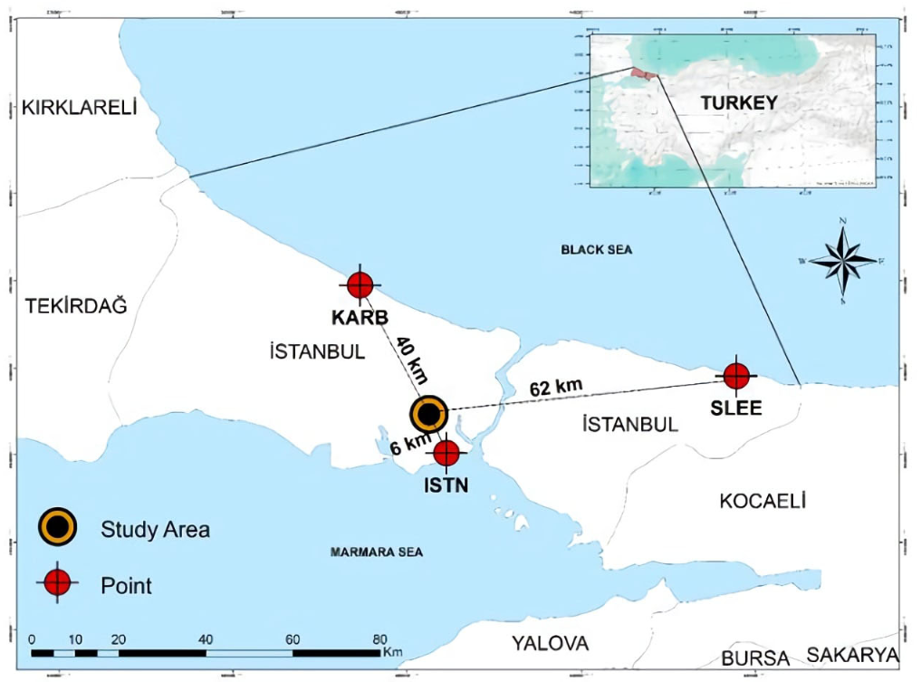
In this study, the effects of the various factors involved in NRTK GNSS positioning accuracy during the day were statistically studied with repeated measurements. The CORS network, which is called TUSAGA Aktif and is used for determining locations in Turkey (especially in Istanbul), was employed in this study (Figure 1). The differences between the position values obtained at different times of the day and according to different correction methods were evaluated via an ANOVA and multiple comparisons.

Figure 1: TUSAGA Aktif NRTK control station positions and the study area in Istanbul
The TUSAGA Aktif Network consists of 158 reference stations over the entire country, three of which are located in Istanbul. The distances between stations range from 80 to 100 km, and static and real-time coordinate positions can be determined in an accurate, quick, and economical way. The control center sends corrections obtained via the VRS, FKP, and MAC techniques to mobile receivers. TUSAGA Aktif Network coordinates were obtained from the 2005.00 reference epoch of the ITRF 96 Datum (Eren et al., 2009). In this study, the coordinates obtained via the NRTK application correspond to the Gauss-Krüger cartographic representation (ITRF 96/GRS 80), which is based on the Transversal Mercator (TM) projection and divided into 3° slices with values of 27°, 30°, 33°, 36°, 39°, 42°, and 45° mid meridian longitude (Л0) for Turkey. The scale factor is 1. The horizontal axis of the coordinate system is the equator, and the vertical axis is the slice median meridian. The orthogonal coordinates of the origin were taken as (500 000, 0) to avoid negative values on the left of the slice. The geographic coordinates of the origin were (Л0, 0) (Basaran, 2019). In this coordinate system, Y and X represent the orthogonal coordinates (right value, upper value), and h represents the ellipsoidal height.
The selected study area was the UZEL location of the Davutpaja Campus, Yildiz Technical University (Figure 2). The KARB, SLEE, and ISTN points, which carry out 24/7 observations within the TUSAGA Aktif Network, were used as fixed locations. The distances between these fixed stations and the application point are given in Figure 1 . Measurements were carried out with an observation period of at least 5 h. The elevation angle was 10° and the recording interval was 10 s. Satellite signals were recorded using the GPS/GLONASS satellite configurations. The final IGS ephemeris was used in post-processing GNSS solutions. Based on these fixed points, adjustments were made according to the least squares method. The coordinates and rms values of the adjusted UZEL point are given in Table 1. The location of UZEL (X, Y, h), with millimeter precision, was determined from the 2005.00 reference epoch of the ITRF 96 Datum, using the GNSS solution software for static GNSS applications. The resulting coordinates were used as actual values to determine the accuracy of the measurements obtained with the NRTK application at different times of the day.

Figure 2: UZEL location
The UZEL locations corresponding to the morning, noon, and evening were determined via the VRS, FKP, and MAC correction techniques used in NRTK. These measurements were taken since the factors affecting NRTK positioning accuracy are different throughout the day. Our measurements were taken at a single point on a sunny summer day when the weather conditions were stable and there was no wind or rain. It is important to mention that the ionization of the ionosphere changes over time according to its position relative to the sun, so the effect of the ionosphere on electromagnetic waves is greater during the day than at night.
In this study, a Topcon HyperPro GNSS receiver was used for the NRTK and static GNSS applications, and the Topcon Link v.8.2.3 software was used for evaluating the NRTK applications. The accuracy of this equipment, as declared by the manufacturer, is 10 mm + 1,0 ppm for horizontal positioning and 15 mm + 1,0 ppm for vertical positioning in environments without high PDOP and ionospheric activity. Furthermore, Topcon Hyper Pro has a tracking feature (GPS+GLONASS) which provides 40% more satellite coverage, eliminating downtime due to poor satellite coverage or obstructions. Multipath correction was applied to the repeated measurements. The Topcon Hyper Pro RTK Receiver has a feature that reduces the effects caused by signal reflection, which was used in our study. Thus, Table 1 shows that the multipath effect was considered, as multipath correction was included in the measurements.
Source: AuthorTable 1: Measurement data for NRTK and static GNSS

For each correction technique, the UZEL location was measured in consecutive time periods (interval of 1 second) averaged over 45 minutes (Table 1). Accuracy and precision were evaluated via the average of repeated measurements and coordinate differences obtained from static GNSS.
Boxplots of the coordinate differences obtained from the averages were elaborated in order to determine whether these differences are sensitive with respect to each other. We also evaluated whether the X, Y, and h coordinates obtained from the NRTK application are significantly different from each other in statistical terms. If a significant difference was found, an ANOVA was performed with the purpose of determining its time period and correction method.
If a difference between groups was found as a result of the ANOVA, post hoc tests were conducted to identify the cause of this difference. If variance homogeneity was achieved, the Tukey test was used. However, in the opposite case, Tamhane's T2 was applied. The SPSS software was used to perform analyses of variance. This software offers a p-value (Sig) of 95% to confirm the significance of the F-test. If the p-value is lower than 0,05, the H0 hypothesis is rejected. Moreover, SPSS constructs sub-groups based on dependent variables (Kalayci, 2010). These sub-groups are determined according to the correction methods and the different times of the day analyzed. The following section shows the results obtained in this regard, which are statistically interpreted with the help of tables and graphs.
Results and discussion
This study considers the effects of many factors involved in the positioning accuracy of NRTK applications. In general, as the geometry of the satellite changes during the morning, noon, and evening hours of the day, positioning accuracy is affected. In addition, the number of satellites that are visible at certain times of the day changes according to their different configurations (GPS, GLONASS). The number of visible satellites should be as large as possible, as many measurements are required to increase positioning accuracy. To be able to see more satellites with GNSS receivers, specific elevation angles are necessary. More satellites can be seen at lower elevation angles, but they negatively affect positioning accuracy due to atmospheric refraction. In this study, the elevation angle as set at 10° for the NRTK applications.
The multipath effect varies according to environmental conditions. The hardware features of receiver antennas are crucial in increasing the accuracy of the height component. In order to eliminate ionospheric delay, a dual-frequency Topcon Hyper Pro GNSS receiver was used, considering the fact that waves of different frequencies will encounter different resistances. In addition, due to seasonal effects and instantaneous changes in the atmosphere, unexpected results can be obtained because of the troposphere.
The data and the corrections were received from the same fixed stations in the NRTK network during measurement. We attempted to ensure the same conditions for different times of the day in order to minimize the effects associated with variability. In this study, repeated observations of a single point were made upon the basis of more than one GNSS reference station. All this, by using the NRTK technique, through which systematic and atmospheric errors can be modeled and different correction methods.
This section shows the results obtained using the materials and methods explained in the previous section. The coordinate differences obtained from the average of repeated measurements were examined to determine if they were sensitive to each other. Boxplots, which contribute to an interpretation of the results, were elaborated to clearly visualize the differences (Figure 3).

Figure 3: Boxplots of the differences obtained from repeated measurements
Figure 3 shows that the differences in the h coordinate are greater than those in the X and Y coordinates for the three correction methods. The values obtained via the VRS correction method are close to the average values. In addition, outlier measurements were observed. All boxplots in Figure 3 show a normal distribution. A comparison of repeated measurements was carried out via an ANOVA.
The accuracy and precision values of measurements obtained via NRTK positioning at the UZEL location are shown with different measurement configurations. Precision values were determined by averaging the measures obtained for each correction method at different times of the day. The coordinates of the UZEL point found via the static GNSS method were regarded as an absolute value. Accuracy values were then determined by subtracting the coordinates found by the static GNSS method from those of each correction method. This is shown in Figure 4.

Figure 4: Accuracy and precision values
It can be observed that the accuracy and precision values along the h coordinate axes are lower than those in the other two axes. In general, the results obtained with the FKP method are better. Differences were observed between the results for different times of the day. The accuracy and precision values of the measurements obtained at noon are lower than those obtained in the morning and evening. The results obtained through the MAC correction method seem to be lower than those of the other two. In the TUSAGA Aktif system, there is no GLONASS satellite data for the MAC method. In this method, the initial lockout time can be extended for network corrections. When the first correction dataset in the network arrives at the GNSS receiver, complex algorithms for fault modeling are used depending on the software employed. The location resolution may take time depending on processor speeds. Since all calculations are carried out on the rover, the appropriate software must be installed. This is why the accuracy of the MAC method may be lower than that of others.
Gumus (2016) attempted to determine whether there is a statistically significant difference between the coordinates obtained with different correction methods at different elevation angles and in epochs in NRTK applications. When comparing statistical data on different variables, the accuracy regarding the h coordinate axis was shown to be lower. The FKP and VRS methods showed different characteristics, while the MAC method showed similar features. By comparing the results of our study against those of Gumus (2016), close values can be observed, albeit with differences in the order of millimeters for different times of the day. In this study, the MAC method differs from the other two along the x and y coordinate axes. This shows that using different correction methods at different times of the day affects the results to a small extent.
We evaluated whether there was a significant difference between the X, Y, and h coordinate values obtained. If there was a difference, its corresponding time period and correction method were identified. The ANOVA showed a normal distribution for each test group while statistically confirming the hypothesis that the variance values of the groups were homogeneous. Table 2 shows the mean and standard deviation values of the X, Y, and h coordinates obtained for different time intervals and correction methods.
Source: AuthorTable 2: Mean and standard deviation values of the X, Y, and h coordinates (m)

The average of the differences for the VRS method in the x coordinate axis obtained during the morning hours is -0,009 m (Table 2), which indicates that the results from the NRTK network vary throughout the day in different coordinate axes. Upon inspecting the boxplots, it was observed that the repeated measurements made using VRS are closely grouped and exhibit little scatter. Many factors may have affected the VRS measurements for the morning hours, such as atmospheric conditions, environmental factors, the number of visible satellites, satellite geometry, signal interruptions, multipath effect, etc.
The ANOVA showed statistically significant differences in the results. Post hoc tests were performed to identify the cause of these differences. Time intervals were determined via pairwise comparisons between the morning, noon, and evening times of the day, as shown in Table 3. To this effect, the mean differences between the averages of the measures obtained were used. The p-value corresponds to the value of F at a 95% significance level. According to this value, there is a significant difference (below 0,05) between the groups.
Source: AuthorTable 3: Pairwise comparisons for different times of the day along the X, Y, and h coordinate axes (m)

Table 3 shows no significant difference between the measurements obtained along the X and h coordinate axes when comparing the noon and evening intervals. For the measurements obtained along the Y coordinate axis, there is no significant difference between the morning and noon hours.
In addition, the averages of the subgroups obtained via the correction methods for different time intervals were compared using means for groups in homogeneous subsets. We tested for statistical significance. Table 4 shows these subsets, including the X, Y, and h coordinate axes and the time intervals. Note that this was done using the SPSS software.
Means for groups are displayed in homogeneous subsets. Subset for alpha = 0,05, Sig. = p-value. The sig. value is not in meters. Source: AuthorTable 4: Subsets of coordinates for different times of the day

For the TUSAGA Aktif Network, along the coordinate axes, the morning interval was defined as a single subset, while the noon and evening periods were incorporated into another one. The latter indicates that these two intervals have similar characteristics, unlike the morning interval. An ANOVA showed that the results were statistically significant. Post hoc tests were performed to identify the cause of differences. Via pairwise comparisons between the average values obtained, the VRS, FKP, and MAC methods were shown to be responsible for the differences (Table 5).
Source: AuthorTable 5: Pairwise comparisons of correction methods along the X, Y, and h coordinate axes

Table 5 shows that there is no significant difference between the FKP and VRS methods regarding the measurements obtained for the X coordinate axes. There are statistically significant differences between the measurements along the Y coordinate axis, unlike those along the h coordinate axis. In general, the MAC correction method shows a statistical difference when compared to the FKP and VRS methods. For Table 6, subsets containing X, Y, and h coordinates from correction methods were created using SPSS.
Source: AuthorTable 6: Subsets of coordinates for each correction method (meter)

In a study conducted by Gumus and Selbesoğlu (2019), the distances (simulated space changes) for the X, Y, and h coordinate axes were measured using NRTK methods and the statistical GNSS technique. The performance of this system was compared to the space changes measured using an interferometer with a precision of 0,1 mm. The performance of the FKP correction method was better, especially in the horizontal axis. In light of the above, the results obtained in our study with the FKP and VRS methods were good for all coordinate axes when compared to the MAC technique. The results regarding measurements taken at different times of the day appear to be influenced by many factors.
The study by Garrido et al. (2018) examined different scenarios (both adequate and inadequate) for a local active network under a variety of topographic, environmental, and meteorological conditions in four different test areas of southern Spain. Multiple observation sessions were conducted over three days in each test area with the aim of assessing the repeatability of RTK solutions. These sessions took place in the morning, noon, and afternoon hours, implying different satellite configurations and atmospheric conditions. Numerical results showed that the observation sessions, satellite configurations, and changes in atmospheric conditions are factors that affect positioning precision and accuracy. Furthermore, it was found that part of the ionospheric effect is now stronger during times of high solar activity. These results support ours. This consistency is important for contributing to the accumulation of knowledge.
Conclusion
This study statistically evaluated the significance of the differences between repeated measurements for a single point obtained at different times of the day (morning, noon, and evening) using the VRS, FKP, and MAC correction methods within the TUSAGA Aktif Network in Turkey. In NRTK applications, some changes were observed in the form of increases or decreases in 3D point positioning values. Many different factors affect the accuracy of NRTK GNSS positioning.
These statistical significances were tested using an ANOVA. By analyzing the results obtained, it was seen that the differences for the averages of the h coordinate axis were higher than those for the other two axes. The values for this axis were less accurate and precise. Although the values obtained with the VRS correction method were close to the average values, the results obtained via the FKP method were generally better. Outlier measurements were observed between repeated measurements. Differences were observed between the morning, noon, and evening intervals. In general, the accuracy and precision values of the morning measurements were lower than those of the other two periods analyzed.
As per the ANOVA, the differences between time intervals were statistically significant. While the noon and evening periods showed similar characteristics, the morning hours showed different characteristics. The results also showed that the differences in terms of the correction methods used were statistically significant. Along the X coordinate axis, the VRS method exhibited a different behavior from MAC and FKP, which performed similarly. All correction methods showed different characteristics along the Y coordinate axis, as well as similarities regarding the h axis.
The results of this study are important for NRTK users to be able to statistically evaluate different measurement configurations and provide the necessary positional reproduction with the desired accuracy and precision.
Acknowledgements
I would like to thank my students, as well as the Land Registry and Cadastre General Directorate for providing the TUSAGA data.
References
References
Basaran, M. (2019). CBS 1 - ek - projeksiyon koordinat sistemleri ve coğrafi bilgi sistemi ortamında kullanımı, Yıldız Teknik Üniversitesi Akademik Veri Yönetimi. https://avesis.yildiz.edu.tr/mbasaran/dokumanlar
Bisnath, S., Saeidi, A., Wang, J. G., and Seepersad, G. (2013). Evaluation of Network RTK performance and elements of certification – A Southern Ontario case study. Geomatica, 67(4), 243-251. https://doi.org/10.5623/cig2013-050
Brown, N. E. (2006). Sequential phased estimation of iono-spheric path delays for improved ambiguity resolution over long GPS baselines [PhD thesis, University of Melbourne].
Brown, N., Geisler, I., and Troyer, L. (2006). RTK rover perfor-mance using the Master Auxiliary Concept. Journal of Glob-al Positioning Systems, 5(1-2), 135-144. DOI: https://doi.org/10.5081/jgps.5.1.135
Brown, N., Keenan, R., Rıchter, B., and Troyer, L. (2005). Ad-vances in ambiguity resolution for RTK applications using the new RTCM V3.0 Master-Auxiliary messages [Conference presentation]. ION GNSS 2005, Long Beach, CA, USA.
Cannon, M. E., Lachapelle, G., Fortes, L. P., Alves, P., and Townsend, B. (2001). The use of multiple reference station VRS for precise kinematic positioning [Conference presenta-tion]. Japan Institute of Navigation, GPS Symposium 2001, Tokyo, Japan.
Chen, X. M., Han, S. W., Rizos, C., and Goh, P. C. (2000). Improving real-time positioning efficiency using the Singa-pore integrated multiple reference station network (SIMRSN) [Conference presentation]. 13th International Technical Meeting of the Satellite Division of The Institute of Navigation (ION GPS 2000), Salt Lake City, UT, USA.
Cina, A., Dabove, P., Manzino, A. M., and Piras, M. (2015). Network Real Time Kinematic (NRTK) Positioning - Description, Architectures and Performances. In S. Jin (Eds.), Satellite Po-sitioning – Methods, Models and Applications (pp. 23-45). IntechOpen. https://doi.org/10.5772/59083
Colombo, O. L., Hernández-Pajares, M., Juan, J. M., Sanz, J., and Talaya, J. (1999). Resolving carrier phase ambiguities on the fly, at more than 100 km from nearest reference site, with the help of ionospheric tomography [Conference presenta-tion]. 12th International Technical Meeting of the Satellite Division of The Institute of Navigation (ION GPS 1999), Nash-ville, TN, USA.
Dabove, P., Manzino, A. M., and Taglioretti, C. (2014). GNSS network products for post-processing positioning: Limitations and peculiarities. Applied Geomatics, 6, 27-36. https://doi.org/10.1007/s12518-014-0122-3
Dai, L., Han, S. W., Wang, J. L., and Rizos, C. (2001). A study on GPS/GLONASS multiple reference station technique for precise realtime carrier phase-based positioning [Confer-ence presentation]. 14th International Technical Meeting of the Satellite Division of The Institute of Navigation (ION GPS 2001), Salt Lake City, UT, USA.
Dardanelli, G., Maltese, A., Pipitone, C., Pisciotta, A., and Lo Brutto, M. (2021). NRTK, PPP or static, that is the question. Test-ing different positioning solutions for GNSS survey. Remote Sensing, 13(7), 1406. https://doi.org/10.3390/rs13071406
Davis, J. L., Herring, T. A., Shapiro, I. I., Rogers, A. E., and Elgered, G. (1985). Geodesy by radio interferometry: Effects of atmospheric modelling errors on estimates of baseline length, Radio Science, 20, 1593-1607. https://doi.org/10.1029/RS020i006p01593
Eren, K., Uzel, T., Gulal, E., Yildirim, O., and Cingoz, A. (2009). Results from a comprehensive Global Navigation Satellite System test in the CORS-TR network: Case study. Journal of Surveying Engineering, 135(1), 10-18. https://doi.org/10.1061/(ASCE)0733-9453(2009)135:1(10)
Euler, H. J., Keenan, C. R., Zebhauser, B. E., and Wübbena, G. (2001). Study of a simplified approach in utilizing information from permanent reference station arrays [Conference presentation] ION GPS-01, Salt Lake City, UT, USA.
Euler, H. J. (2006). Real-time RTK messages for permanent reference station applications standardized by RTCM [Con-ference presentation]. IAG Symposium, Munich, Germany.
Gao, Y., Li, Z., and McLellan, J. F. (1997). Carrier phase based regional area differential GPS for decimeter-level positioning and navigation [Conference presentation]. ION GPS-97: 10th International Technical Meeting of the Satellite Division of the Institute of Navigation, Kansas City, MO, USA.
Gandolfi, S., Tavasci, L., and Poluzzi, L. (2017). Study on GPS-PPP precision for short observation sessions. GPS solu-tions, 21, 887-896. https://doi.org/10.1007/s10291-016-0575-4
Garrido, M. S., Giménez, E., Lacy, M. C., and Gil, A. J. (2011). Testing precise positioning using RTK and NRTK corrections provided by MAC and VRS approaches in SE Spain. Journal of Spatial Science, 56(2), 169-184. https://doi.org/10.1080/14498596.2011.623341
Garrido, M. S., de Lacy, M. C., and Rojas, A. M. (2018). Impact of tropospheric modelling on GNSS vertical precision: An empirical analysis based on a local active network. International Journal of Digital Earth, 11(9), 880-896. https://doi.org/10.1080/17538947.2017.1367040
Ge, M., Gendt, G., Rothacher, M. A., Shi, C., and Liu, J. (2008). Resolution of GPS carrier-phase ambiguities in precise point positioning (PPP) with daily observations. Journal of Geode-sy, 82(7), 389. https://doi.org/10.1007/s00190-007-0187-4
Gumus, K. (2016). A research on the effect of different measuring configurations in Network RTK applications. Measurement, 78, 334-343. https://doi.org/10.1016/j.measurement.2015.10.022
Gumus, K., and Selbesoglu, M. O. (2019). Evaluation of NRTK GNSS positioning methods for displacement detection by a newly designed displacement monitoring system. Measurement, 142, 131-137. https://doi.org/10.1016/j.measurement.2019.04.041
Gökdaş, Ö., and Özlüdemir, M. T. (2020). A variance model in NRTK-based geodetic positioning as a function of baseline length. Geosciences, 10(7), 262. https://doi.org/10.3390/geosciences10070262
Grejner-Brzezinska, D. A., Kashani, I., and Wielgosz, P. (2005). On accuracy and reliability of instantaneous network RTK as a function of network geometry, station separation and data processing strategy. GPS Solutions, 93, 179-193. https://doi.org/10.1007/s10291-005-0130-1
Han, S. W. (1997). Carrier phase-based long-range GPS kine-matic positioning [PhD thesis, University of New South Wales]. DOI: https://doi.org/10.1007/978-3-662-03482-8_94
Hu, G. R., Khoo, H. S., Goh, P. C., and Law, C. L. (2003). De-velopment and assessment of GPS virtual reference stations for RTK positioning. Journal of Geodesy, 77(5), 202-302. https://doi.org/10.1007/s00190-003-0327-4
Janssen, V. (2009). A comparison of the VRS and MAC princi-ples for network RTK [Conference presentation]. IGNSS Sym-posium, Surfers Paradise, Queensland, Australia.
Janssen, V., Grinter, T., and Roberts, C. (2011). Can RTK GPS be used to improve cadastral infrastructure? Engineerıng Jour-nal, 15(1), 43. https://doi.org/10.4186/ej.2011.15.1.43
Jin, S. (Ed.) (2012). Global navigation satellite systems: Signal, theory and applications. Books on Demand. DOI: https://doi.org/10.5772/1134
Kahveci, M., Alioglu, D., and Çetin, G. (2021). Tek frekansli GNSS alıcılarında kullanılan iyonosferik etki düzeltme model-lerinin karşılaştırılması. Konya Journal of Engineering Scienc-es, 9(2), 428-441. https://doi.org/10.36306/konjes.849391
Kalaycı, Ş. (2010). SPSS uygulamali çok değişkenli istatistik teknikleri. Asil yayin dağitim Ltd. Şti.
Klobuchar, J. A., and Doherty, P. H. (1990). The statistics of ionospheric time delay for GPS ranging on L1 [Conference presentation]. ION GPS-90, 3rd International Technical Meet-ing of the Satellite Division of the Institute of Navigation, Colorado Springs, CO, USA.
Kudrys, J., and Krzyek R. (2011). Analysis of coordinates time series obtained using the NAWGEO service of the ASG-EUPOS system. Geomatics and Environmental Engineering, 5(4), 39-46.
Kun, S., and Yong, W. (2006). The development and applica-tion of CORS technology and its value in the solution for en-vironment protect in the GMS. GMSARN International Jour-nal, 1, 69-74. https://gmsarnjournal.com/home/wp-content/uploads/2015/08/vol1no2-3.pdf
Landau, H., Vollath, U., and Chen, X. (2002). Virtual reference station systems. Journal of Global Positioning Systems, 1(2), 137-143. DOI: https://doi.org/10.5081/jgps.1.2.137
Landau, H., Vollath, U., and Chen, X. (2003). Virtual reference stations versus broadcast solutions in network RTK – Ad-vantages and limitations [Conference presentation]. GNSS 2003 – The European Navigation Conference, Graz, Austria.
Leica Geosystems (2005). Networked Reference Stations: Take it to the MAX. Leica Geosystems.
Li, X., Ge, M., Dai, X., Ren, X., Fritsche, M., Wickert, J., and Schuh, H. (2015). Accuracy and reliability of multi-GNSS real-time precise positioning: GPS, GLONASS, BeiDou, and Gali-leo. Journal of geodesy, 89(6), 607-635. https://doi.org/10.1007/s00190-015-0802-8
Lin, M. (2006). RTCM 3.0 Implementation in network RTK and performance analysis [Master’s thesis, University of Calgary]. http://hdl.handle.net/1880/101496
Martin, A., and McGovern, E. (2012). An evaluation of the performance of network RTK GNSS services in Ireland [Con-ference paper]. https://arrow.tudublin.ie/cgi/viewcontent.cgi?article=1001&context=dsiscon
Öğütcü, S., and Kalaycı, İ. (2018). Accuracy and precision of network-based RTK techniques as a function of baseline dis-tance and occupation time. Arabian Journal of Geoscienc-es, 11, 354. https://doi.org/10.1007/s12517-018-3712-2
Park, B., and Kee C. (2010). The Compact Network RTK Meth-od: An effective solution to reduce GNSS temporal and spa-tial decorrelation error. Journal of Navigation, 63(2), 343-362. https://doi.org/10.1017/S0373463309990440
Pirti, A., Arslan, N., Deveci, B., Aydin, O., Erkaya, H., and Hosbas, R. G. (2009). Real-time kinematic GPS for cadastral surveying. Survey Review, 41(314), 339-351. https://doi.org/10.1179/003962609X451582
Pirti, A., and Hosbas, R. G. (2019). Role of CORS RTK (Network RTK) mode measurements in determination of the forest boundary: A case study of ISKI-CORS. Forestry Ideas, 25(2), 394-403. https://forestry-ide-as.info/issues/issues_Index.php?pageNum_rsIssue=2&totalRows_rsIssue=19&journalFilter=64
Raquet, J. (1998). Development of a method for kinematic gps carrier-phase ambiguity resolution using multiple refer-ence receivers [PhD thesis, University of Calgary].
Rizos, C. (2002). Network RTK research and implementation – A geodetic perspective. Journal of Global Positioning Systems, 1(2), 144-150. DOI: https://doi.org/10.5081/jgps.1.2.144
Tarig, A. (2012). Positioning with wide-area GNSS Networks: Concept and application positioning. Scientific Research, 3, 1-6. https://doi.org/10.4236/pos.2012.31001
Vollath, U., Buecherl, A., and Landau, H. (2000a). Long range RTK positioning using virtual reference stations [Conference presentation]. 2000 National Technical Meeting of The Insti-tute of Navigation, Anaheim, CA, USA.
Vollath, U., Buecherl, A., Landau, H., Pagels, C., and Wagner, B. (2000b). Multi base RTK positioning using virtual reference stations [Conference presentation]. 2000 National Technical Meeting of The Institute of Navigation, Anaheim, CA, USA.
Wanninger, L. (2002). Virtual reference stations for centimeter level kinematic positioning [Conference presentation]. 15th International Technical Meeting of the Satellite Division of The Institute of Navigation (ION GPS 2002), Portland, OR, USA.
Wanninger, L. (2003). Virtual reference stations (VRS). GPS Solutions, 7, 143-144. https://doi.org/10.1007/s10291-003-0060-8
Wei, E., Chai, H., and An, Z. (2006). VRS: virtual observations generation algorithm. Journal of Global Positioning Systems, 5(1-2), 76-81. DOI: https://doi.org/10.5081/jgps.5.1.76
Wielgosz, P., Grejner-Brzezinska, D. A., and Kashani, I. (2003). Network approach to precise GPS navigation [Conference presentation]. 59th Annual Meeting of The Institute of Navi-gation and CIGTF 22nd Guidance Test Symposium, Albu-querque, NM, USA.
Wübbena, G., Bagge, A., Seeber, G., Volker, B., and Hankemeier, P. (1996). Reducing distance dependent errors for real time precise DGPS applications by establishing refer-ence station networks [Conference presentation]. 1996 Na-tional Technical Meeting of The Institute of Navigation, Santa Monica, CA.
Wübbena , G., Bagge, A. and Schmitz, M. (2001). Network based techniques for RTK applications [Conference presen-tation]. GPS JIN 2001, Tokyo, Japan.
Wübbena, G., and Bagge, A. (2002). RTCM Message Type 59-FKP for transmission of FKP. http://www.geopp.com/pdf/geopp-rtcm-fkp59.pdf
How to Cite
APA
ACM
ACS
ABNT
Chicago
Harvard
IEEE
MLA
Turabian
Vancouver
Download Citation
CrossRef Cited-by
1. Carmen Maria Giordano, Valentina Alena Girelli, Alessandro Lambertini, Maria Alessandra Tini, Antonio Zanutta. (2025). UAV Data Collection Co-Registration: LiDAR and Photogrammetric Surveys for Coastal Monitoring. Drones, 9(1), p.49. https://doi.org/10.3390/drones9010049.
2. Carmen Maria Giordano, Valentina Alena Girelli, Alessandro Lambertini, Emanuele Mandanici, Maria Alessandra Tini, Renata Archetti, Massimo Ponti, Antonio Zanutta. (2025). Evaluating Direct Georeferencing of UAV-LiDAR Data Through QGIS Tools: An Application to a Coastal Area. Remote Sensing, 18(1), p.7. https://doi.org/10.3390/rs18010007.
Dimensions
PlumX
Article abstract page views
Downloads


License
Copyright (c) 2024 Kutalmis Gumus

This work is licensed under a Creative Commons Attribution 4.0 International License.
The authors or holders of the copyright for each article hereby confer exclusive, limited and free authorization on the Universidad Nacional de Colombia's journal Ingeniería e Investigación concerning the aforementioned article which, once it has been evaluated and approved, will be submitted for publication, in line with the following items:
1. The version which has been corrected according to the evaluators' suggestions will be remitted and it will be made clear whether the aforementioned article is an unedited document regarding which the rights to be authorized are held and total responsibility will be assumed by the authors for the content of the work being submitted to Ingeniería e Investigación, the Universidad Nacional de Colombia and third-parties;
2. The authorization conferred on the journal will come into force from the date on which it is included in the respective volume and issue of Ingeniería e Investigación in the Open Journal Systems and on the journal's main page (https://revistas.unal.edu.co/index.php/ingeinv), as well as in different databases and indices in which the publication is indexed;
3. The authors authorize the Universidad Nacional de Colombia's journal Ingeniería e Investigación to publish the document in whatever required format (printed, digital, electronic or whatsoever known or yet to be discovered form) and authorize Ingeniería e Investigación to include the work in any indices and/or search engines deemed necessary for promoting its diffusion;
4. The authors accept that such authorization is given free of charge and they, therefore, waive any right to receive remuneration from the publication, distribution, public communication and any use whatsoever referred to in the terms of this authorization.