Published
Spatial variability of infiltration and its relationship to some physical properties
Variabilidad espacial de la infiltración y su relación con algunas propiedades físicas
DOI:
https://doi.org/10.15446/ing.investig.v30n2.15742Keywords:
geoestatistics, semivarigram, kriging, porosity (en)geoestadística, semivariograma, kriging, porosidad (es)
Downloads
Water infiltration into soil is one of the basic factors for estimating irrigation intensity according to the plants' requirements; this is aimed at avoiding problems of surface run-off and degradation. The purpose of the present investigation was to determine the spatial variation of infiltration and its relationship to some physical properties of soil by means of geostatistical techniques in Typic Plinthaquult soils having average texture and flat relief. A 113-point mesh was designed, having a regular distance of 10 m between points, samples being taken from 0 to 0.20 meters depth. Sand, silt and clay content, bulk density, macroporosity, microporosity and total porosity were determined. Infiltration tests were carried out in the field by means of a 15 cm diameter ring. Descriptive statistics and geostatistics were used for analysing the data. Infiltration, silt and microporosity data did not fit a normal distribution curve. Infiltration had high variability, having an average 36.03 mm h-1. Total porosity was 56.73%, this being the only property that did not show spatial dependency. The smallest ranges were observed for bulk density, macroporosity and microporosity, having values of less than 40 m. The smallest degrees of spatial dependence were observed for infiltration, silt and clay, evidence also being shown of the influence of silt and clay on infiltration rate. Contour maps were constructed; fitting them to the semivariogram models, together with studying the correlations, led to establishing relationships between the properties.
La infiltración del agua en el suelo es uno de los factores básicos para estimar la intensidad de riego de acuerdo a los requerimientos de las plantas, para evitar problemas de escorrentía superficial y de degradación. El objetivo del presente trabajo fue el de determinar la variabilidad espacial de la infiltración y su relación con algunas propiedades físicas del suelo, mediante técnicas geoestadísticas, en un Typic Plinthaquults de textura media y relieve plano. Se diseñó una malla de 113 puntos, con distancia regular entre puntos de 10 m, tomando muestras entre 0-0,20 m de profundidad. Se determinaron contenidos de arena, limo y arcilla, densidad aparente, macroporosidad, microporosidad y porosidad total. La infiltración fue realizada en campo mediante anillo de 15 cm de diámetro. Los datos se analizaron por medio de estadística descriptiva y geoestadística. La infiltración, el limo y la microporosidad no se aproximaron a la distribución normal. La infiltración presentó alta variabilidad, con una media de 36,03 mm h-1. La porosidad total fue de 56,73%, siendo la única propiedad que no presentó dependencia espacial. Lo menores rangos se observaron para la densidad aparente, macroporosidad y microporosidad, con valores inferiores a 40 m. Los menores grados de dependencia espacial fueron apreciados en la infiltración, limo y arcilla, evidenciándose también la influencia del limo y la arcilla en la tasa de infiltración. Los mapas de contorno elaborados, cuando éstos se ajustan a modelos de semivariogramas, junto al estudio de las correlaciones, permite establecer relaciones entre las propiedades.
Spatial variability of infiltration and its relationship to some physical properties
Alba Leonor da Silva Martins1 Emanoel Gomes de Moura2 y Jesús H. Camacho Tamayo3
1 Agronoma. M. Sc. Ph D(c)., en Agronomía (Ciencia del Suelo), FCAV/ UNESP, Jaboticabal, SP. Vía de acesso Prof. Paulo Donato Castellane, s/n, CEP 14870-900. albaleonor@ibest.com 2 Agrónomo. M. Sc. Ph D. Profesor Adjunto, Universidad Estatal de Maranhâo, Sâo Luis MA, Brasil. egmoura@elo.com.br 3 Ingeniero Agrícola. M. Sc. ProfesorAsistente, Facultad de Ingeniería, Universidad Nacional de Colombia, Bogotá, Colombia. jhcamachot@unal.edu.co
RESUMEN
La infiltración del agua en el suelo es uno de los factores básicos para estimar la intensidad de riego de acuerdo a los requerimientos de las plantas, para evitar problemas de escorrentía superficial y de degradación. El objetivo del presente trabajo fue el de determinar la variabilidad espacial de la infiltración y su relación con algunas propiedades físicas del suelo, mediante técnicas geoestadísticas, en un Typic Plinthaquults de textura media y relieve plano. Se diseñó una malla de 113 puntos, con distancia regular entre puntos de 10 m, tomando muestras entre 0-0,20 m de profundidad. Se determinaron contenidos de arena, limo y arcilla, densidad aparente, macroporosidad, microporosidad y porosidad total. La infiltración fue realizada en campo mediante anillo de 15 cm de diámetro. Los datos se analizaron por medio de estadística descriptiva y geoestadística. La infiltración, el limo y la microporosidad no se aproximaron a la distribución normal. La infiltración presentó alta variabilidad, con una media de 36,03 mm h-1. La porosidad total fue de 56,73%, siendo la única propiedad que no presentó dependencia espacial. Lo menores rangos se observaron para la densidad aparente, macroporosidad y microporosidad, con valores inferiores a 40 m. Los menores grados de dependencia espacial fueron apreciados en la infiltración, limo y arcilla, evidenciandose también la influencia del limo y la arcilla en la tasa de infiltración. Los mapas de contorno elaborados, cuando éstos se ajustan a modelos de semivariogramas, junto al estudio de las correlaciones, permite establecer relaciones entre las propiedades.
Palabras clave: geoestadística, semivariograma, kriging, porosidad.
ABSTRACT
Water infiltration into soil is one of the basic factors for estimating irrigation intensity according to the plants requirements; this is aimed at avoiding problems of surface run-off and degradation. The purpose of the present investigation was to determine the spatial variation of infiltration and its relationship to some physical properties of soil by means of geostatistical techniques in Typic Plinthaquult soils having average texture and flat relief. A 113 point mesh was designned, having a regular distance of 10 m between points, samples being taken from 0 to 0.20 meters depth. Sand, silt and clay content, bulk density, macroporosity, microporosity and total porosity were determined. Infiltration tests were carried out in the field by means of a 15 cm diameter ring. Descriptive statistics and geostatistics were used for analysing the data. Infiltration, silt and microporosity data did not fit a normal distribution curve. Infiltration had high variability, having an average 36.03 mm h-1. Total porosity was 56.73%, this being the only property that did not show spatial dependency. The smallest ranges were observed for bulk density, macroporosity and microporosity, having values of less than 40 m. The smallest degrees of spatial dependence were observed for infiltration, silt and clay, evidence also being shown of the influence of silt and clay on infiltration rate. Contour maps were constructed; fitting them to the semivariogram models, together with studying the correlations, led to establishing relationships between the properties.
Keywords: geoestatistics, semivarigram, kriging, porosity.Recibido: mayo 04 de 2009 Aceptado: junio 10 de 2010
Introducción
Los Typic Plinthaquult del centro-norte del estado de Marañón (Brasil) son suelos que presentan varias limitaciones como la formación de capas altamente adensadas, costras superficiales y restricción a la percolación del agua, dificultando su manejo en la producción agrícola. De acuerdo con Embrapa (2006) esta clase de suelo, que es influenciado por el continuo proceso de humedecimiento y secado, favorece el desarrollo del horizonte plíntico, permitiendo que el terreno permanezca saturado, sujeto a fluctuaciones del nivel freático. Por esto es importante comprender la relación de la infiltración y el movimiento del agua en este suelo, con las propiedades físicas, para realizar un manejo adecuado en la producción de cultivos.
El conocimiento de la velocidad de infiltración y la cantidad de agua acumulada es de gran importancia debido a su aplicación en el sector agrícola y ambiental, pues permite estimar la escorrentía superficial, transporte de partículas en suspensión, disponibilidad de sedimentos, capacidad de recarga de acuíferos, definir sistemas de irrigación y estudiar los efectos de diferentes prácticas de manejo de suelos, en el espacio y en el tiempo (Machiwal et al., 2006; Strudley et al., 2008).
Tradicionalmente, el análisis y manejo de las propiedades físicas del suelo se hace desconociendo las particularidades del terreno, las condiciones en el momento del laboreo, así como los requerimientos del cultivo, siendo importante efectuar una evaluación previa dentro de los conceptos de sostenibilidad. Este desconocimiento induce a continuar implementando sistemas de manejo de suelo que favorecen la degradación (Amézquita, 2004). Por otra parte, el muestreo aleatorio es insuficiente para expresar las relaciones entre las propiedades del suelo, conduciendo en ocasiones a errores en la toma de decisiones, ya que pueden presentarse grandes variaciones en una misma propiedad debido a las alteraciones provocadas por las actividades agrícolas (Strudley et al., 2008). Un adecuado manejo del suelo puede depender del conocimiento de la dependencia e interacción espacial de las propiedades del suelo (Montenegro y Montenegro, 2006).
El uso de herramientas como la geoestadística describe con mejor precisión el comportamiento espacial de una propiedad, que conjuntamente con el conocimiento, la experiencia y el manejo de las variables en estudio por parte del investigador, reducen la variación atribuida a posibles errores aleatorios (Faraco et al., 2008). La geoestadística verifica la dependencia espacial y la variabilidad de una misma propiedad entre muestras cercanas, así como la correlación entre distintas propiedades, a través del semivariograma (Vieira, 2000).
La variabilidad espacial de la tasa de infiltración y su ajuste a modelos teóricos de semivariogramas ha sido estudiada por varios autores (Lennartz et al., 2009; Rodríguez-Vásquez et ál., 2008), verificando que el contenido de arcilla influye directamente en la infiltración del agua en el suelo y está fuertemente correlacionada con la densidad aparente y la porosidad (Rodríguez-Vásquez et ál., 2008).
El sistema de preparación del suelo y la presencia de residuos superficiales también influyen en la tasa de infiltración del agua, como fue verificado por Medina y Leite (1985), trabajando en un ultisol, encontrando que alta densidad de residuos en la superficie crea condiciones favorables para el movimiento e infiltración del agua en el suelo, siendo semejantes a las de bosque nativo debido a la adecuada protección superficial.
En general, la tasa de infiltración presenta una alta variabilidad espacial para un suelo considerado homogéneo, por lo cual el objetivo del presente trabajo consistió en determinar la variabilidad espacial de la infiltración superficial de un Typic Plinthaquults y su relación con diferentes propiedades físicas del suelo.
Materiales y métodos
Localización y caracterización de la zona de trabajo
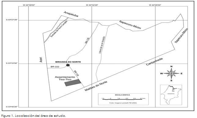
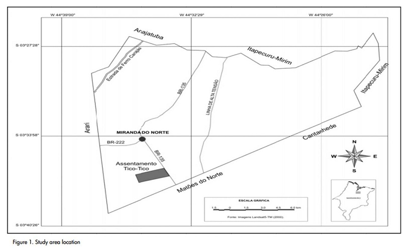
El estudio se realizó en el municipio de Miranda del Norte (Marañón-Brasil), en un lote de 1 ha cultivado con maíz (Zea mays L.) bajo sistema agroforestal, zona donde predomina la agricultura familiar, localizado a 3° 36 de latitud sur y 44° 34 de longitud oeste (Figura 1). El suelo predominante es un Typic Plinthaquults con textura media y relieve plano. Según la clasificación climática de Köppen, la región se encuentra en el tipo Aw-, clima tropical húmedo, con temperatura media de 27 °C y precipitación entre 1.600 y 2.000 mm año-1, concentradas entre diciembre y junio, predominando el clima seco en los otros meses.
Muestreo y análisis de laboratorio
Para el muestreo se diseñó una malla de 113 puntos, con distancia regular entre puntos de 10 m, en un área de aproximadamente 1 ha. En cada punto se tomaron muestras de suelos disturbadas e indisturbadas, a una profundidad de 0-0,20 m. Las muestras disturbadas fueron secadas al aire hasta alcanzar el punto de equilibrio, siendo desterronadas y pasadas por malla de 2 mm para la realización del análisis granulométrico, estableciendo así los contenidos de arena, limo y arcilla, mediante una muestra de 10 g sometida a agitación lenta durante 16 horas, en 100 ml de solución con NaOH (0,1 mol L-1), donde el contenido de arcilla es obtenido mediante una alícuota retirada con pipeta (Gee y Bauder, 1986). Las muestras indisturbadas fueron tomadas con anillos volumétricos de 100 cm3 para determinar la densidad aparente, macroporosidad, microporosidad y porosidad total, mediante mesa de tensión, de acuerdo a la metodología descrita por Kiehl (1979).
La infiltración superficial fue determinada en el periodo seco, en cada punto de muestreo, utilizando anillo de 15 cm de diámetro, y el uso del permeámetro de Guelph, modificado por el Instituto Agronómico de Campinas (IAC), garantizando así una carga constante de agua. La infiltración es calculada mediante la ecuación de Reynolds y Elrick (1985), modificada por Vieira (1988):

donde I es la tasa de infiltración de agua en suelo saturado (mm h-1), Dp el diámetro del permeámetro (9 cm), Da el diámetro del anillo (15 cm) y Q el flujo de agua estimada en suelo saturado (mm min-1).
Análisis estadístico
Inicialmente se realizó análisis de los datos mediante estadística descriptiva, usándose el programa SPSS 16.0, para calcular media, mediana, coeficiente de variación (CV), mínimo, máximo, asimetría, curtosis, y el test de Kolmogorov-Smirnov. De esta manera se verificó la normalidad, comportamiento que no es indispensable cuando se relaciona con técnicas geoestadísticas, pero proporciona mejores predicciones si los datos se ajustan a la distribución normal (Diggle y Ribeiro, 2000). Para el análisis del CV se empleó la clasificación propuesta por Warrick y Nielsen (1980), que indica baja variabilidad para CV con valores inferiores del 12%, variabilidad media para CV entre 12 y 60% y alta variabilidad para CV mayores de 60%. También se realizó el análisis de correlación lineal de Pearson con el fin de identificar la correlación entre la infiltración y las diferentes propiedades físicas del suelo.
La dependencia espacial de las propiedades físicas y de la infiltración se analizó mediante semivariogramas. Para el ajuste de los modelos teóricos de los semivariogramas experimentales se consideró la teoría de variables regionalizadas, que dispone de diferentes métodos de análisis de variación espacial, siendo una de ellas el semivariograma (Vieira, 2000), el cual es estimado por:
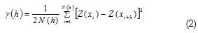
donde Z(xi) e Z(xi+h) son los valores observados de una variable, separados una distancia h, y N(h) es el número de pares experimentales de observaciones, separados por la distancia h. El semivariograma es representado gráficamente por (h) frente a h. A partir del ajuste de un modelo se estiman los coeficientes del modelo teórico: efecto pepita (C0), meseta (C0+C1) y alcance (A).
También se estimó el grado de dependencia espacial (GDE) con base en la razón entre el efecto pepita y la meseta (C/Co+C), considerada fuerte para GDE superior de 75%, moderada para GDE entre 25% y 75%, y débil para GDE inferior de 25% (Cambardella, 1994). Los semivariogramas fueron calculados con el programa GS+ (Robertson, 1998), que adopta como criterios para la selección del modelo el mayor valor del coeficiente de determinación (R2), el menor valor de la suma de cuadrado de residuos (SQR) y un coeficiente de validación cruzada (CVC) próximo de uno. Una vez determinada la dependencia espacial, se efectuó la predicción de cada propiedad en zonas no muestreadas mediante kriging, representados en mapas de contorno que se elaboraron utilizando el programa Surfer (1999).
Análisis de resultados y discusión
Los valores encontrados para la media y la mediana son similares para cada una de las propiedades estudiadas, indicando distribuciones simétricas, lo cual se verifica por los valores de asimetría y curtosis cercanos a cero, en todas las propiedades, aproximándose a la distribución normal, excepto para la infiltración, propiedad que presentó valores distantes entre la media y la mediana (Tabla 1). El comportamiento de normalidad de estas propiedades también es reportado por Cruz et al. (2010) y Ramírez-López et al. (2008). La prueba de Kolmogorov-Smirnov confirmó la aproximación a la distribución normal en la mayoría de las propiedades, mostrando que la infiltración no se ajustó a la distribución normal, así como el limo y la microporosidad.
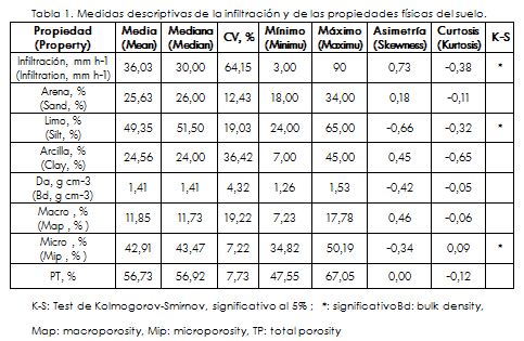
De acuerdo al criterio dado por Warrick y Nielsen (1980), se tiene que la infiltración presentó alta variabilidad, con CV de 64,15%. Rodríguez-Vásquez et al. (2008) también encontraron alta variabilidad de esta propiedad en un andisol con alto contenido de limo. La densidad aparente fue la propiedad que menor CV presentó, indicando baja variabilidad, junto con la microporosidad y la porosidad total. Baja variabilidad de la densidad aparente y de la porosidad total es también reportada por Ramírez-López et al. (2008). Las otras propiedades presentaron variabilidad media. De las partículas del suelo, la arcilla fue la que mostró mayor variabilidad.
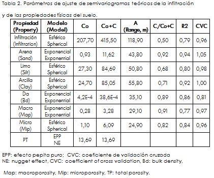
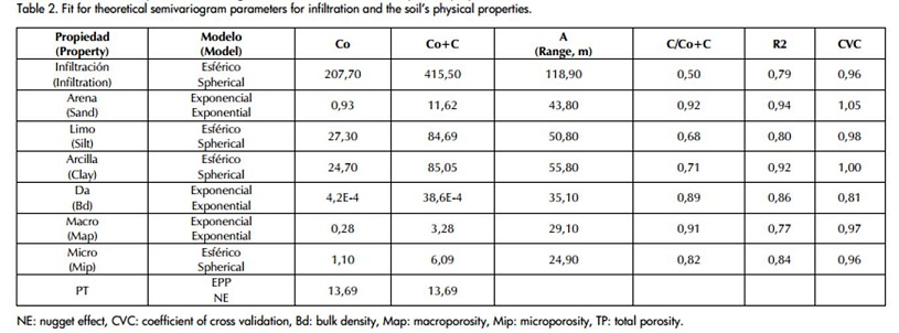
La porosidad total fue la única propiedad que no mostró ajuste al modelo teórico de semivariograma, indicando que su comportamiento en el suelo es aleatorio, presentando efecto pepita puro (Tabla 2). El modelo esférico fue el predominante entre las otras propiedades analizadas, ajustado para la infiltración, limo, arcilla y microporosidad. La arena, densidad aparente y macroporosidad se ajustaron a modelos exponenciales.
El ajuste de los modelos es adecuado, dados los valores del factor de determinación, siempre superior a 0,75, siendo la arena y la arcilla las propiedades que mejor se ajustaron a los modelos. Los valores del coeficiente de validación cruzada son próximos a 1 para la mayoría de las propiedades, donde la densidad aparente tuvo el menor valor (0,81). La infiltración exhibió el mayor alcance y fue la única propiedad con alcance superior a 100 m.
La macroporosidad y la microporosidad, fueron las propiedades con menor alcance. Respecto del grado de dependencia espacial (GDE), la infiltración ofreció el menor valor, con una dependencia espacial moderada. La arcilla y el limo también mostraron un GDE moderado. Las otras propiedades presentaron GDE fuerte, con valores superiores de 0,80.
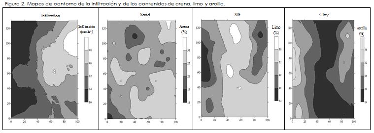
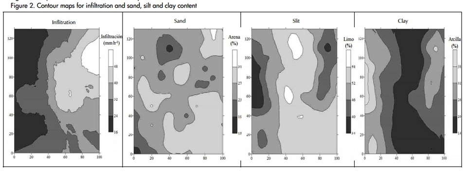
La infiltración no tuvo correlación significativa con las propiedades físicas (Tabla 3). Se observa que la infiltración está relacionada directamente con los contenidos de limo e inversamente con los de arcilla. Este mismo comportamiento fue reportado por RodríguezVásquez et al. (2008). Dicha relación entre la infiltración y los contenidos de limo y arcilla es verificada en los mapas de contorno (Figura 2), donde áreas de mayor infiltración corresponden a zonas de mayor contenido de limo y menor de arcilla
En la arena se apreció correlación significativa e inversa con la arcilla y la microporosidad. Los contenidos de limo y arcilla exhibieron una correlación fuerte e inversa, como también se observa en los mapas de contorno (Figura 2), donde áreas de mayor contenido de limo, corresponden a zonas de menor contenido de arcilla y viceversa.
A significant and inverse correlation for sand was seen with clay and microporosity. Silt and clay content showed a strong inverse correlation, as can be seen in the contour maps (Figure 2) where areas of greater silt content corresponded to areas of lower clay content and vice versa.
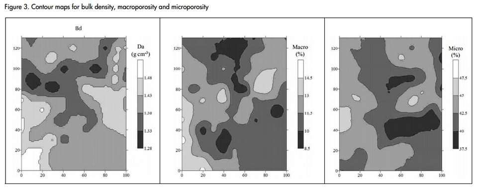
La densidad aparente también evidenció una correlación positiva y significativa con la microporosidad, mostrando mapas de contorno moderamente semejantes (Figura 3). La porosidad total, propiedad en la que no se determinó dependencia espacial, expuso correlación inversa con los contenidos de arena y limo, y correlación directa con los contenidos de arcilla, así como con la densidad aparente, macroporosidad y microporosidad.
Los mapas de contorno obtenidos confirman la relación entre las variables analizadas (Figuras 2 y 3), además de la variabilidad espacial existente en el suelo, indicando la conveniencia de realizar prácticas localizadas de manejo del suelo, de acuerdo a las condiciones del área y los requerimientos del cultivo, con el objetivo de disminuir costos de producción y la degradación del suelo, originados en el manejo convencional.

Conclusiones
La infiltración y las propiedades del suelo, analizados mediante estadística descriptiva y geoestadística, evidencian la alta variabilidad del suelo, mostrando el comportamiento de la infiltración y las propiedades físicas en el espacio, siendo una herramienta importante para la toma de decisiones ya que permite establecer parámetros de calidad del suelo directa-mente relacionados con la producción agrícola.
La correlación lineal estimada para las propiedades permitió identificar cuáles son las propiedades mejor relacionadas, relaciones que son confirmadas espacialmente mediante los mapas de contorno obtenidos a partir del kriging cuando las propiedades se ajustan a modelos teóricos de semivariogramas.
Agradecimientos
Al Departamento Administrativo de Ciencia, Tecnología e Innovación (Colciencias) de Colombia, por el apoyo brindado al tercer autor.
Bibliografía
Amézquita, E., La fertilidad física del suelo., In: Congreso Latinoamericano y de la Ciencia del Suelo, 16., Memorias. Cartagena, Colombia, Sociedad Colombiana de la Ciencia del Suelo, CD, 2004.
Cambardella, C. A., Moorman,T. B., Novak, J. M., Parkin, T. B., Karlen, D. L., Turco, R. F., Konopka, A. E., Field-scale variability of soil of soil properties in central lowa soils., Soil Science Society America Journal, Vol. 58, No. 5, Sep., 1994, pp. 1501-1511.
Cruz, J. S., Assis Júnior, R. N., Matias, S. S. R., Camacho-Tamayo, J. H., Tavares, R. C., Análise espacial de atributos físicos e carbono orgânico em argissolo vermelho-amarelo cultivado com cana-de-açúcar., Ciência e Agrotecnologia, Vol. 34, No. 2, Mar., 2010, pp. 271-278 .
Diggle, P. J., Ribeiro, J. R., Model Based Geostatistics., 1. ed. Sâo Paulo: Associaçâo Brasileira de Estatística, 2000, pp. 129.
EMBRAPA. Centro Nacional de Pesquisa de Solos., Sistema brasileiro de classificaçâo de Solos, 2ªed., Rio de Janeiro. (Embrapa Solos), 2006, pp. 306.
Faraco, M. A., Uribe-Opazo, M. A., Silva, E. A. A., Johann, J. A., Borssoi, J. A., Seleçâo de modelos de variabilidade espacial para elaboraçâo de mapas temáticos de atributos físicos do solo e produtividade da soja., Revista Brasileira de Ciência do Solo, Vol. 32, No. 2, Mar., 2008, pp. 463-476.
Gee, G. W., Baudar, J. W., Particle-size analysis., In: KLUTE, A. Methods of soil analysis, 2a. Ed. Madison: American Society of Agronomy, part 1, 1986, pp. 383-411.
Kiehl, E. J., Manual de edafologia, relações solo planta., Sâo Paulo, Ceres, 1979, 264p.
Lennartz, B., Horn, R., Duttmann, R., Gerke, H. H., Tippkötter, R., Eickhorst, T., Janssen, I., Janssen, M., Rüth, B., Sander, T., Shi, X., Sumfleth, K., Taubner, H., Zhang, B., Ecological safe management of terraced rice paddy landscapes., Soil and Tillage Research, Vol. 102, No. 2, Mar., 2009, pp.179-192.
Machiwal, D., Jha, M. K., Mal, B. C., Modelling Infiltration and quantifying Spatial Soil Variability in a Wasteland of Kharagpur, India., Biosystems Engineering, Vol.95, No. 4, Dec., 2006, pp. 569 582.
Medina, B. F., Leite, J. A., Influência de três sistemas de manejo e duas coberturas vegetais na infiltraçâo de água em um Latossolo Amarelo em Manaus AM., Pesquisa Agropecuária Brasileira, Vol. 20, No. 11, Nov., 1985, pp. 1323-1331.
Montenegro, A. A. A., Montenegro, S. M. G. L., Variabilidade espacial de classes de textura, salinidade e condutividade hidráulica de solos em planície aluvial., Revista Brasileira de Engenharia Agrícola e Ambiental, Vol. 10, No. 1, Jan., 2006, pp.30-37.
Ramírez-López, L., Reina-Sánchez, A., Camacho-Tamayo, J. H., Variabilidad espacial de atributos físicos de un Typic Haplustox de los llanos orientales de Colombia., Engenharia Agrícola, Vol.28, No. 1, Jan., 2008, pp. 55-63.
Reynolds, W. D., Elrick, D. E., In situ measurement of fied-satured hydraulic conductivity, sorptivity, and the α-parameter using the Guelph permeameter., Soil Science, Vol. 140, No. 4, Oct., 1985, pp. 292-302.
Robertson, G. P. GS+., Geostatistics for the environmental sciences (version 5.1 for windows)., Plainwell: Michigan, Gamma Design Software, 1998, pp. 152.
Rodríguez-Vásquez, A. F., Aristizábal-Castillo, A. M., Camacho Tamayo, J. H., Variabilidad espacial de los modelos de infiltración de Philip y Kostiakov en un suelo ándico., Engenharia Agrícola, Vol. 28, No. 1, Jan., 2008, pp. 64-75.
Surfer for windows., Realese 8.0. Contouring and 3D surface mapping for scientist's engineers. User's Guide., New York: Golden software, Inc, 2000.
Strudley, M.W., Green, T.R., Ascough II, J.C., Tillage effects on soil hydraulic properties in space and time: State of the science., Soil and Tillage Research, Vol., No. 1, April 2008, pp. 4-48.
Vieira, S. R., Permeâmetro: novo aliado na avaliaçâo de manejo do solo., O agronômico, Vol. 47, No.1, Jan., 1998, pp. 32-33.
Vieira, S. R., Geoestatística em estudo de variabilidade espacial do solo: tópicos em ciência do solo., Viçosa: Sociedade Brasileira de Ciência do solo, 2000. Vol. 1, pp. 55.
Warrick, A.W., Nielsen, D.R., Spatial variability of soil physical properties in the field., Applications of soil physics, New York: Academic Press, Hillel, D. (ed.), 1980, pp. 319-344.
Spatial variability of infiltration and its relationship to some physical properties
Alba Leonor da Silva Martins1, Emanoel Gomes de Moura2 and Jesús H. Camacho Tamayo3
1 Agronomist. M. Sc. Ph D(c)., In Agronomy (Soil Science), FCAV/ UNESP, Jaboticabal, SP. Vía de acesso Prof. Paulo Donato Castellane, s/n, CEP 14870-900. albaleonor@ibest.com 2Agronomist. M. Sc. Ph D. Assistant Professor, Universidad Estatal de Maranhão, São Luis – MA, Brasil. egmoura@elo.com.br 6 Agricultural Engineer. M.Sc. Professor, School of engineering, Universidad Nacional de Colombia, Bogotá, Colombia. jhcamachot@unal.edu.co
ABSTRACT
Water infiltration into soil is one of the basic factors for estimating irrigation intensity according to the plants' requirements; this is aimed at avoiding problems of surface run-off and degradation. The purpose of the present investigation was to determine the spatial variation of infiltration and its relationship to some physical properties of soil by means of geostatistical techniques in Typic Plinthaquult soils having average texture and flat relief. A 113 point mesh was designed, having a regular distance of 10 m between points, samples being taken from 0 to 0.20 meters depth. Sand, silt and clay content, bulk density, macroporosity, microporosity and total porosity were determined. Infiltration tests were carried out in the field by means of a 15 cm diameter ring. Descriptive statistics and geostatistics were used for analysing the data. Infiltration, silt and microporosity data did not fit a normal distribution curve. Infiltration had high variability, having an average 36.03 mm h-1. Total porosity was 56.73%, this being the only property that did not show spatial dependency. The smallest ranges were observed for bulk density, macroporosity and microporosity, having values of less than 40 m. The smallest degrees of spatial dependence were observed for infiltration, silt and clay, evidence also being shown of the influence of silt and clay on infiltration rate. Contour maps were constructed; fitting them to the semivariogram models, together with studying the correlations, led to establishing relationships between the properties.
Keywords: geoestatistics, semivarigram, kriging, porosity.
Received: may 04th 2009
Accepted: jun 10th 2010
Introduction
The Typic Plinthaquult soils of the central northern part of the State of Marañón (Brazil) have inherent limitations thereby hampering their management for agricultural production, such as the formation of highly condensed layers, surface crust formation and restricted water percolation. According to Embrapa (2006), this kind of soil which is influenced by the continual process of wetting and drying therefore favours the development of a plinthic horizon, meaning that the soil remains saturated and is subject to water table level fluctuations. Understanding the relationship between infiltration and water movement in this soil (with its physical properties) is thus important in ensuring adequate crop production management.
Ascertaining the infiltration rate and accumulated water quantity is of great importance due to their application in the agricultural and environmental sector, since this leads to estimating surface run-off, suspended particle transport, sediment availability, aquifers capacity to become refilled, defining irrigation systems and studying the effects of different soil management practices (Machiwal et al., 2006; Strudley et al., 2008).
The physical properties of soil have traditionally been analysed and managed without the characteristics of a particular soil being known or the conditions at the time of cultivation, as well as crop requirements; ensuring prior evaluation in line with the concept of sustainability is thus extremely important. Such lack of knowledge leads to degradation-favouring soil management practices being continued (Amézquita, 2004). On the other hand, random sampling is insufficient for determining relationships between soil properties, occasionally leading to mistakes in decision-making since wide-ranging variations can show up in the same property due to changes caused by agricultural activity (Strudley et al., 2008). Suitable soil management can depend on knowledge regarding soil properties' dependence and spatial interaction (Montenegro and Montenegro, 2006).
Tools such as geostatistics can more precisely describe a property's spatial behaviour which, together with knowledge, experience and management of the particular variables being studied, reduces variation attributed to possible random errors (Faraco et al., 2008). Geostatistics verify the same property's spatial dependence and variability amongst closely-related samples, as well as the correlation between different properties, by using a semivariogram (Viera, 2000).
The infiltration rate's spatial variability and its fit to theoretical semivariogram models has been studied by several authors (Lennartz et al., 2009, Rodríguez-Vásquez et al., 2008), verifying that clay content has a direct influence on water infiltration into soil and is strongly correlated with bulk density and porosity (Rodríguez-Vásquez et al., 2008).
The system of soil preparation and the presence of surface residues also influence water infiltration rate, as has been verified by Medina and Leite (1985) working in an ultisol-type soil who found that high surface residue density created favourable conditions for water movement and infiltration into soil, this being similar to what happens in native woods due to suitable surface protection.
A Typic Plinthaquult soil's infiltration rate generally shows high spatial variability for a soil considered homogenous; the present paper was thus aimed at determining the spatial variability of surface infiltration for a Typic Plinthaquult soil and its relationship to such soil's physical properties.
Materials and methods
Study site location and characteristics
The study was carried out in Miranda del Norte (Marañón state, Brazil) located at 3° 36' south latitude and 44° 34' west longitude (Figure 1) on a 1 hectare plot planted with corn (Zea mays L.), agro-forestry system, in an area where family agriculture predominates. The predominant soil is a Typic Plinthaquult, having medium texture and flat relief. According to Köppen climatic classification, the region is located in an Aw'- humid tropical climate, having an average 27°C temperature and 1,600 to 2,000 mm year-1 rainfall, concentrated in December and June, a dry climate predominating in the other months.
Sampling and laboratory analysis
A 113-point mesh was designed for sampling, having a regular 10 m distance between points in an area measuring about 1 ha. Disturbed and undisturbed soil samples were taken at each point, at 00.20 m depth. The disturbed samples were air-dried until they reached equilibrium point; once being clod, they were passed through a 2 mm mesh for granulometric analysis. Sand, silt and clay content were thus established by means of a 10 g sample subjected to slow agitation for 16 h, in 100 ml of solution with NaOH (0.1 mol L-1); clay content was obtained by means of an aliquot drawn out with a pipette (Gee and Bauder, 1986). The undisturbed samples were taken from 100 cm3 volumetric rings to determine bulk density, macroporosity, microporosity and total porosity by means of a tension table, following the methodology described by Kiehl (1979).
Infiltration rate was determined during a dry period, at each sampling point, by means of a 15 cm diameter ring, using a Guelph permeameter modified by the Agronomical Institute of Campinas (IAC), thus guaranteeing constant water load. Infiltration was calculated by means of Reynolds and Elrick's equation (1985), modified by Vieira (1988):
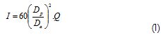
where I is water infiltration rate into saturated soil (mm h-1), Dp is the permeameter diameter (9 cm), Da is the ring diameter (15 cm) and Q is estimated water flow in saturated soil (mm min-1).
Statistical analysis
Descriptive statistics were initially used for analysing the data, using SPSS 16.0 software for calculating the mean, median, coefficient of variation (CV), minimum, maximum, skewness, kurtosis and the Kolmogorov-Smirnov test. Normality was thus verified, a pattern which is not indispensible when related to geostatistical techniques but does give better predictions when data are fit to a normal distribution (Diggle and Ribeiro, 2000). The classification proposed by Warrick and Nielsen (1980) was used for CV analysis; this indicates low CV variability for values below 12%, average CV variability between 12% and 60% and high CV variability when greater than 60%. Pearson linear correlation was also carried out to identify the correlation between infiltration and the soil's different physical properties.
The physical properties and infiltration's spatial dependence were analysed by using semivariograms. The theory of regionalised variables was taken into consideration for the fit of the theoretical experimental semivariogram models; this has different methods for analysing spatial variation, one of them being the semivariogram (Vieira, 2000) which is estimated by:

where (xi) and Z(xi+h) are a variable's observed values, separated by a distance h, and N(h) is the number of experimental pairs of observations, separated by distance h. The semivariogram is graphically represented by γ(h) versus h. The theoretical model's coefficients are estimated from the fit of the model: nugget effect (C0), plateau (C0+C1) and range (A).
The degree of spatial dependence (DSP) was also estimated, based on the ratio between the nugget effect and the plateau (C/Co+C), being considered strong for DSP when above 75%, moderate DSP between 25% and 75% and weak for DSP when less than 25% (Cambardella, 1994). GS+ software (Robertson, 1998) was used for calculating the semivariograms; this adopts the largest determination coefficient value (R2), the lowest value for the sum of the square of the residue (SQR) and a crossed validation coefficient (CVC) close to one as criteria for selecting the model. Once spatial dependence had been determined, each property in the non-sampled areas was predicted by kriging, represented on contour maps that were drawn up using Surfer software (1999).
Analysis of results and discussion
The values found for the average and median were similar for each of the studied properties, thereby indicating symmetrical distributions. This was verified by skewness and kurtosis values being close to zero for all properties; they approached normal distribution, except for infiltration, a property showing distinct values between the average and the mean (Table 1).. These properties' normality pattern has also been reported by Cruz et al., (2010) and Ramírez-López et al., (2008). The Kolmogorov-Smirnov test confirmed normal distribution for most properties, showing that infiltration did not fit a normal distribution, as well as silt and microporosity.

According to Warrick and Nielsen's criteria (1980), it was seen that infiltration had high variability (64.15% CV). Rodríguez-Vásquez et al., (2008) also found high variability for this property in a high silt content Andisol soil. Bulk density was the property showing the least CV (indicating low variability) together with microporosity and total porosity. Low variability for bulk density and total porosity have also been reported by Ramírez-López et al., (2008). The other properties showed average variability.Clay was the soil particle showing the greatest variability.
Total porosity was the only property which did not fit a theoretical semivariogram model indicating that its behaviour in the soil was random, thereby showing the pure nugget effect (Table 2). The spherical model was the predominant model among the other properties analysed; it fit infiltration, silt, clay and microporosity data. Sand, bulk density and macroporosity data fit the exponential models.
The fit to the models was adequate, given the determination factor values which were always above 0.75. Sand and clay were the properties having the best fit for the models. The coefficient of crossed validation values were close to 1 for most e properties, whereas bulk density had the lowest value (0.81). Infiltration showed the greatest range and was the only property having a range greater than 100 m.
Macroporosity and microporosity were the properties having the least range. Regarding the degree of spatial dependence (DSD), infiltration showed the lowest value, having moderate spatial dependence. Clay and silt also showed a moderate DSS. The other properties showed high DSD, having greater than 0.80 values.
Infiltration did not have a significant correlation with the physical properties (Table 3). It can be seen that infiltration was directly related to silt content and inversely to clay content. The same pattern has been reported by Rodríguez-Vásquez et al., (2008). This relationship between infiltration and silt and clay content is verified on the contour maps (Figure 2) where areas having a greater infiltration rate correspond to areas of greater silt content and lower clay content.
A significant and inverse correlation for sand was seen with clay and microporosity. Silt and clay content showed a strong inverse correlation, as can be seen in the contour maps (Figure 2) where areas of greater silt content corresponded to areas of lower clay content and vice versa.
Bulk density also had a positive and significant correlation with microporosity, leading to moderately similar contour maps (Figure 3). Total porosity (a property in which spatial dependence was not found) had an inverse correlation with sand and silt content and a direct correlation with clay content, as well as with bulk density, macroporosity and microporosity.
The contour maps confirmed the relationship between the variables analysed here (Figures 2 and 3) as well as the spatial variability existing in the soil, thereby indicating the convenience of carrying out localised soil management practices according to the conditions of the area and crop requirements, aimed at lowering production costs and the soil degradation which results from conventional management.
Conclusions
Infiltration and soil properties analysed by means of descriptive statistics and geostatistics revealed the soil's high variability in its infiltration and physical property patterns, this being an important tool for decision-making since it leads to establishing the soil quality parameters which are directly related to agricultural production.
The linear correlation estimated for the properties lead to identifying which ones were most closely related; such relationships were spatially confirmed by means of contour maps obtained by kriging when the properties fit the theoretical semivariogram models.
Acknowledgements
We would like to thank COLCIENCIAS (the Colombian Science, Technology and Innovation Department) for providing financial support for the third author.
Bibliografía
Amézquita, E., La fertilidad física del suelo., In: Congreso Latinoamericano y de la Ciencia del Suelo, 16., Memorias. Cartagena, Colombia, Sociedad Colombiana de la Ciencia del Suelo, CD, 2004.
Cambardella, C. A., Moorman,T. B., Novak, J. M., Parkin, T. B., Karlen, D. L., Turco, R. F., Konopka, A. E., Field-scale variability of soil of soil properties in central lowa soils., Soil Science Society America Journal, Vol. 58, No. 5, Sep., 1994, pp. 1501-1511.
Cruz, J. S., Assis Júnior, R. N., Matias, S. S. R., Camacho-Tamayo, J. H., Tavares, R. C., Análise espacial de atributos físicos e carbono orgânico em argissolo vermelho-amarelo cultivado com cana-de-açúcar., Ciência e Agrotecnologia, Vol. 34, No. 2, Mar., 2010, pp. 271-278 .
Diggle, P. J., Ribeiro, J. R., Model Based Geostatistics., 1. ed. Sâo Paulo: Associaçâo Brasileira de Estatística, 2000, pp. 129.
EMBRAPA. Centro Nacional de Pesquisa de Solos., Sistema brasileiro de classificaçâo de Solos, 2ªed., Rio de Janeiro. (Embrapa Solos), 2006, pp. 306.
Faraco, M. A., Uribe-Opazo, M. A., Silva, E. A. A., Johann, J. A., Borssoi, J. A., Seleçâo de modelos de variabilidade espacial para elaboraçâo de mapas temáticos de atributos físicos do solo e produtividade da soja., Revista Brasileira de Ciência do Solo, Vol. 32, No. 2, Mar., 2008, pp. 463-476.
Gee, G. W., Baudar, J. W., Particle-size analysis., In: KLUTE, A. Methods of soil analysis, 2a. Ed. Madison: American Society of Agronomy, part 1, 1986, pp. 383-411.
Kiehl, E. J., Manual de edafologia, relações solo planta., Sâo Paulo, Ceres, 1979, 264p.
Lennartz, B., Horn, R., Duttmann, R., Gerke, H. H., Tippkötter, R., Eickhorst, T., Janssen, I., Janssen, M., Rüth, B., Sander, T., Shi, X., Sumfleth, K., Taubner, H., Zhang, B., Ecological safe management of terraced rice paddy landscapes., Soil and Tillage Research, Vol. 102, No. 2, Mar., 2009, pp.179-192.
Machiwal, D., Jha, M. K., Mal, B. C., Modelling Infiltration and quantifying Spatial Soil Variability in a Wasteland of Kharagpur, India., Biosystems Engineering, Vol.95, No. 4, Dec., 2006, pp. 569 582.
Medina, B. F., Leite, J. A., Influência de três sistemas de manejo e duas coberturas vegetais na infiltraçâo de água em um Latossolo Amarelo em Manaus AM., Pesquisa Agropecuária Brasileira, Vol. 20, No. 11, Nov., 1985, pp. 1323-1331.
Montenegro, A. A. A., Montenegro, S. M. G. L., Variabilidade espacial de classes de textura, salinidade e condutividade hidráulica de solos em planície aluvial., Revista Brasileira de Engenharia Agrícola e Ambiental, Vol. 10, No. 1, Jan., 2006, pp.30-37.
Ramírez-López, L., Reina-Sánchez, A., Camacho-Tamayo, J. H., Variabilidad espacial de atributos físicos de un Typic Haplustox de los llanos orientales de Colombia., Engenharia Agrícola, Vol.28, No. 1, Jan., 2008, pp. 55-63.
Reynolds, W. D., Elrick, D. E., In situ measurement of fied-satured hydraulic conductivity, sorptivity, and the α-parameter using the Guelph permeameter., Soil Science, Vol. 140, No. 4, Oct., 1985, pp. 292-302.
Robertson, G. P. GS+., Geostatistics for the environmental sciences (version 5.1 for windows)., Plainwell: Michigan, Gamma Design Software, 1998, pp. 152.
Rodríguez-Vásquez, A. F., Aristizábal-Castillo, A. M., Camacho Tamayo, J. H., Variabilidad espacial de los modelos de infiltración de Philip y Kostiakov en un suelo ándico., Engenharia Agrícola, Vol. 28, No. 1, Jan., 2008, pp. 64-75.
Surfer for windows., Realese 8.0. Contouring and 3D surface mapping for scientist's engineers. User's Guide., New York: Golden software, Inc, 2000.
Strudley, M.W., Green, T.R., Ascough II, J.C., Tillage effects on soil hydraulic properties in space and time: State of the science., Soil and Tillage Research, Vol., No. 1, April 2008, pp. 4-48.
Vieira, S. R., Permeâmetro: novo aliado na avaliaçâo de manejo do solo., O agronômico, Vol. 47, No.1, Jan., 1998, pp. 32-33.
Vieira, S. R., Geoestatística em estudo de variabilidade espacial do solo: tópicos em ciência do solo., Viçosa: Sociedade Brasileira de Ciência do solo, 2000. Vol. 1, pp. 55.
Warrick, A.W., Nielsen, D.R., Spatial variability of soil physical properties in the field., Applications of soil physics, New York: Academic Press, Hillel, D. (ed.), 1980, pp. 319-344.
References
Amézquita, E., La fertilidad física del suelo., In: Congreso Latinoamericano y de la Ciencia del Suelo, 16., Memorias. Cartagena, Colombia, Sociedad Colombiana de la Ciencia del Suelo, CD, 2004.
Cambardella, C. A., Moorman, T. B., Novak, J. M., Parkin, T. B., Karlen, D. L., Turco, R. F., Konopka, A. E., Field-scale variability of soil of soil properties in central Iowa soils., Soil Science Society America Journal, Vol. 58, No. 5, Sep., 1994, pp. 1501-1511. DOI: https://doi.org/10.2136/sssaj1994.03615995005800050033x
Cruz, J. S., Assis Júnior, R. N., Matias, S. S. R., Camacho-Tamayo, J. H., Tavares, R. C., Análise espacial de atributos físicos e carbono orgânico em argissolo vermelho-amarelo cultivado com cana-de-açúcar., Ciência e Agrotecnologia, Vol. 34, No. 2, Mar., 2010, pp. 271-278. DOI: https://doi.org/10.1590/S1413-70542010000200001
Diggle, P. J., Ribeiro, J. R., Model Based Geostatistics., 1. ed. Sâo Paulo: Associaçâo Brasileira de Estatística, 2000, pp. 129.
EMBRAPA. Centro Nacional de Pesquisa de Solos., Sistema brasileiro de classificaçâo de Solos, 2ªed., Rio de Janeiro. (Embrapa – Solos), 2006, pp. 306.
Faraco, M. A., Uribe-Opazo, M. A., Silva, E. A. A., Johann, J. A., Borssoi, J. A., Seleçâo de modelos de variabilidade espacial para elaboraçâo de mapas temáticos de atributos físicos do solo e produtividade da soja., Revista Brasileira de Ciência do Solo, Vol. 32, No. 2, Mar., 2008, pp. 463-476. DOI: https://doi.org/10.1590/S0100-06832008000200001
Gee, G. W., Baudar, J. W., Particle-size analysis., In: KLUTE, A. Methods of soil analysis, 2a. Ed. Madison: American Society of Agronomy, part 1, 1986, pp. 383-411.
Kiehl, E. J., Manual de edafologia, relações solo – planta., Sâo Paulo, Ceres, 1979, 264p.
Lennartz, B., Horn, R., Duttmann, R., Gerke, H. H., Tippkötter, R., Eickhorst, T., Janssen, I., Janssen, M., Rüth, B., Sander, T., Shi, X., Sumfleth, K., Taubner, H., Zhang, B., Ecological safe management of terraced rice paddy landscapes., Soil and Tillage Research, Vol. 102, No. 2, Mar., 2009, pp.179-192. DOI: https://doi.org/10.1016/j.still.2008.07.010
Machiwal, D., Jha, M. K., Mal, B. C., Modelling Infiltration and quantifying Spatial Soil Variability in a Wasteland of Kharagpur, India., Biosystems Engineering, Vol.95, No. 4, Dec., 2006, pp. 569– 582. DOI: https://doi.org/10.1016/j.biosystemseng.2006.08.007
Medina, B. F., Leite, J. A., Influência de três sistemas de manejo e duas coberturas vegetais na infiltraçâo de água em um Latossolo Amarelo em Manaus –AM., Pesquisa Agropecuária Brasileira, Vol. 20, No. 11, Nov., 1985, pp. 1323-1331.
Montenegro, A. A. A., Montenegro, S. M. G. L., Variabilidade espacial de classes de textura, salinidade e condutividade hidráulica de solos em planície aluvial., Revista Brasileira de Engenharia Agrícola e Ambiental, Vol. 10, No. 1, Jan., 2006, pp.30-37. DOI: https://doi.org/10.1590/S1415-43662006000100005
Ramírez-López, L., Reina-Sánchez, A., Camacho-Tamayo, J. H., Variabilidad espacial de atributos físicos de un Typic Haplustox de los llanos orientales de Colombia., Engenharia Agrícola, Vol.28, No. 1, Jan., 2008, pp. 55-63. DOI: https://doi.org/10.1590/S0100-69162008000100006
Reynolds, W. D., Elrick, D. E., In situ measurement of fied-satured hydraulic conductivity, sorptivity, and the α-parameter using the Guelph permeameter., Soil Science, Vol. 140, No. 4, Oct., 1985, pp. 292-302. DOI: https://doi.org/10.1097/00010694-198510000-00008
Robertson, G. P. GS+., Geostatistics for the environmental sciences (version 5.1 for windows)., Plainwell: Michigan, Gamma Design Software, 1998, pp. 152.
Rodríguez-Vásquez, A. F., Aristizábal-Castillo, A. M., Camacho Tamayo, J. H., Variabilidad espacial de los modelos de infiltración de Philip y Kostiakov en un suelo ándico., Engenharia Agrícola, Vol. 28, No. 1, Jan., 2008, pp. 64-75. DOI: https://doi.org/10.1590/S0100-69162008000100007
Surfer for windows., Realese 8.0. Contouring and 3D surface mapping for scientist's engineers. User's Guide., New York: Golden software, Inc, 2000.
Strudley, M.W., Green, T.R., Ascough II, J.C., Tillage effects on soil hydraulic properties in space and time: State of the science., Soil and Tillage Research, Vol., No. 1, April 2008, pp. 4-48. DOI: https://doi.org/10.1016/j.still.2008.01.007
Vieira, S. R., Permeâmetro: novo aliado na avaliaçâo de manejo do solo., O agronômico, Vol. 47, No.1, Jan., 1998, pp. 32-33.
Vieira, S. R., Geoestatística em estudo de variabilidade espacial do solo: tópicos em ciência do solo., Viçosa: Sociedade Brasileira de Ciência do solo, 2000. Vol. 1, pp. 55.
Warrick, A.W., Nielsen, D.R., Spatial variability of soil physical properties in the field., Applications of soil physics, New York: Academic Press, Hillel, D. (ed.), 1980, pp. 319-344. DOI: https://doi.org/10.1016/B978-0-12-348580-9.50018-3
How to Cite
APA
ACM
ACS
ABNT
Chicago
Harvard
IEEE
MLA
Turabian
Vancouver
Download Citation
CrossRef Cited-by
1. Cecilia Medina, Jesús H. Camacho-Tamayo, César A. Cortés. (2012). Soil penetration resistance analysis by multivariate and geostatistical methods. Engenharia Agrícola, 32(1), p.91. https://doi.org/10.1590/S0100-69162012000100010.
2. Javier Giovanni Álvarez Herrera, Hernán David Ruiz Berrío, Darwin Fernando Acosta Tova. (2021). Evaluación geoestadística de atributos hidrofísicos del suelo en la granja Tunguavita, Paipa, Colombia. Ciencia e Ingeniería Neogranadina, 31(1), p.127. https://doi.org/10.18359/rcin.5396.
3. Baha-Eddine Badouna, El-Hadi Mechentel. (2022). Contribution for Establishment of Software for Determining the Tensile Strength of Agricultural Tools. Simple and Complex Shaped Tools. Acta Technologica Agriculturae, 25(4), p.211. https://doi.org/10.2478/ata-2022-0031.
4. Ramón Giraldo, William Caballero, Jesús Camacho-Tamayo. (2018). Mantel test for spatial functional data. AStA Advances in Statistical Analysis, 102(1), p.21. https://doi.org/10.1007/s10182-016-0280-1.
5. G.A. Zadorozhnaya. (2016). Seasonal dynamics of ecomorphic structure of chernozem. AgroChemistry and Soil Science, (85), p.53. https://doi.org/10.31073/acss85-08.
6. Helber Milton Orjuela-Matta, Danny Wilson Sanjuanelo-Corredor, Jonathan Vásquez-Lizcano, Katherin Cubides-Posada, Julián Francisco Rodríguez-Tibaquirá, Juan Carlos Torres-Rodríguez, Heiner Alfonso Ramírez-Poveda. (2023). Integrated processing methodology to identify the spatial variability of accumulated infiltration for agricultural soil. Revista U.D.C.A Actualidad & Divulgación Científica, 26(1) https://doi.org/10.31910/rudca.v26.n1.2023.2365.
Dimensions
PlumX
Article abstract page views
Downloads


License
Copyright (c) 2010 Alba Leonor da Silva Martins, Emanoel Gomes de Moura, Jesús H. Camacho Tamayo

This work is licensed under a Creative Commons Attribution 4.0 International License.
The authors or holders of the copyright for each article hereby confer exclusive, limited and free authorization on the Universidad Nacional de Colombia's journal Ingeniería e Investigación concerning the aforementioned article which, once it has been evaluated and approved, will be submitted for publication, in line with the following items:
1. The version which has been corrected according to the evaluators' suggestions will be remitted and it will be made clear whether the aforementioned article is an unedited document regarding which the rights to be authorized are held and total responsibility will be assumed by the authors for the content of the work being submitted to Ingeniería e Investigación, the Universidad Nacional de Colombia and third-parties;
2. The authorization conferred on the journal will come into force from the date on which it is included in the respective volume and issue of Ingeniería e Investigación in the Open Journal Systems and on the journal's main page (https://revistas.unal.edu.co/index.php/ingeinv), as well as in different databases and indices in which the publication is indexed;
3. The authors authorize the Universidad Nacional de Colombia's journal Ingeniería e Investigación to publish the document in whatever required format (printed, digital, electronic or whatsoever known or yet to be discovered form) and authorize Ingeniería e Investigación to include the work in any indices and/or search engines deemed necessary for promoting its diffusion;
4. The authors accept that such authorization is given free of charge and they, therefore, waive any right to receive remuneration from the publication, distribution, public communication and any use whatsoever referred to in the terms of this authorization.