Published
Hazard Maps of Shallow Landslides Associated to Infiltration Processes in the Sapuyes River Basin
Mapas de Amenaza por Deslizamientos Superficiales Relacionados con Procesos de Infiltración en la Cuenca del Río Sapuyes
DOI:
https://doi.org/10.15446/ing.investig.v41n1.84611Keywords:
Shallow landslides, deterministic, infiltration, hazard maps, risk assessment (en)Deslizamientos superficiales, determinístico, infiltración, mapa de amenaza, evaluación de riesgo (es)
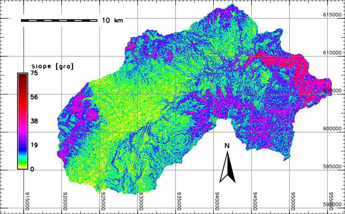
Hazard mapping of shallow landslides associated with infiltration processes at a regional scale was carried out by means of the spatial and temporal distribution of safety factor and its classification, within hazard level ranges, into cells that represent hillside units in Sapuyes river basin, located near the city of Pasto in the Nariño department. Hazard assessment follows the theoretical approaches of the Iverson model (2000), which takes into account the redistribution of underground pore pressures associated with the transient infiltration of the rain and its effects on the time and location of landslides, considering that shallow landslides are associated with periods of rain with a short duration and greater intensity. Results showed that both the pressure heads and the safety factor are valid approximations for hazard analysis at regional scale and allow observing the transient physical process involved in the development of shallow landslides.
La elaboración de mapas de amenaza por deslizamientos superficiales relacionados con procesos de infiltración a escala regional se realizó mediante la distribución espaciotemporal del factor de seguridad y su clasificación en rangos de nivel de amenaza, en celdas que representan unidades de ladera en la cuenca del río Sapuyes, situada cerca de la ciudad de Pasto, en el departamento de Nariño. La evaluación de la amenaza sigue las aproximaciones teóricas del modelo de Iverson (2000), que tiene en cuenta la redistribución de las presiones de poros subterráneas asociadas a la infiltración transitoria de la lluvia y sus efectos en el tiempo y ubicación de deslizamientos, teniendo en cuenta que los deslizamientos superficiales están asociados a periodos de lluvia de corta duración y de mayor intensidad. Los resultados mostraron que tanto las cabezas de presión como el factor de seguridad son aproximaciones válidas para un análisis de amenaza a escala regional y permiten observar el proceso físico transitorio involucrado en el desarrollo de deslizamientos superficiales.
References
Anderson, S. A., and Sitar, N. (1995). Analysis of Rainfall-Induced Debris Flows. Journal of Geotechnical Engineering, 121(7), 544-552. https://doi.org/10.1061/(ASCE)0733-9410(1995)121:7(544)
Aristizábal, E., Martínez, H., and Vélez, J. I. (2010). Una revisión sobre el estudio de movimientos en masa detonados por lluvias. Revista de la Academia Colombiana de Ciencias Exactas, físicas y Naturales, 34(131), 209-227. https://raccefyn.co/index.php/raccefyn/issue/view/181/169
Avila, G. E., Cubillos, C. E., Granados, A. E., Medina, E., Rodríguez, É. A., Rodríguez, C. E., and Ruiz, G. L. (2015). Guía Metodológica: Para Estudios de Amenaza, Vulnerabilidad y Riesgo por Movimientos en Masa. Bogotá: Universidad Nacional de Colombia, Servicio Geológico Colombiano.
Avila Álvarez, G. E., Cubillos Peña, C. E., Granados Becerra, A. E., Medina Bello, E., Rodríguez Castiblanco, É. A., Rodríguez Pineda, C. E., and Ruiz Peña, G. L. (2015). Guía Metodológica: Para Estudios de Amenaza, Vulnerabilidad y Riesgo por Movimientos en Masa. Bogotá: Universidad Nacional de Colombia, Servicio Geológico Colombiano.
Baum, R. L., Godt, J. W., and Savage, W. Z. (2010). Estimating the timing and location of shallow rainfall-induced landslides using a model for transient, unsaturated infiltration. Journal of Geophysical Research-Earth Surface, 115. https://doi.org/10.1029/2009jf001321
Chae, B. G., Lee, J. H., Park, H. J., and Choi, J. (2015). A method for predicting the factor of safety of an infinite slope based on the depth ratio of the wetting front induced by rainfall infiltration. Natural Hazards and Earth System Sciences, 15(8), 18351849. https://doi.org/10.5194/nhess-15-1835-2015
Chien, L. K., Hsu, C. F., and Yin, L. C. (2015). Warning Model for Shallow Landslides Induced by Extreme Rainfall. Water, 7(8), 43624384. https://doi.org/10.3390/w7084362
Cho, S. E. (2009). Infiltration analysis to evaluate the surficial stability of two-layered slopes considering rainfall characteristics. Engineering Geology, 105(12), 3243. https://doi.org/10.1016/j.enggeo.2008.12.007
Fannin, R. J., Jaakkola, J., Wilkinson, J. M. T., and Hetherington, E. D. (2000). Hydrologic response of soils to precipitation at Carnation Creek, British Columbia, Canada. Water Resources Research, 36(6), 14811494. https://doi.org/10.1029/2000WR900027
IGAC (2004). Estudio general de suelos y zonificación de tierras Departamento de Nariño. Bogotá: Instituto Geográfico Agustín Codazzi.
Iida, T. (1999). A stochastic hydrogeomorphological model for shallow landsliding due to rainstorm. CATENA, 34(3), 293-313. http://dx.doi.org/10.1016/S0341-8162(98)00093-9
Ivanov, V., Arosio, D., Tresoldi, G., Hojat, A., Zanzi, L., Papini, M., and Longoni, L. (2020). Investigation on the Role of Water for the Stability of Shallow Landslides— Insights from Experimental Tests. Water, 12(4), 1203. https://doi.org/10.3390/w12041203
Iverson, R. M. (2000). Landslide triggering by rain infiltration. Water Resources Research, 36(7), 1897-1910.
Kim, D., Im, S., Lee, S. H., Hong, Y., and Cha, K.S. (2010). Predicting the rainfall-triggered landslides in a forested mountain region using TRIGRS model. Journal of Mountain Science, 7(1), 83-91. https://doi.org/10.1007/s11629-010-1072-9
Montrasio, L. and Valentino, R. (2008). A model for triggering mechanisms of shallow landslides. Natural Hazards and Earth System Sciences, 8(5), 1149-1159. https://doi.org/10.5194/nhess-8-1149-2008
Nguyen, B.-Q. -V., Lee, S.-R., and Kim, Y.T. (2020). Spatial probability assessment of landslide considering increases in pore-water pressure during rainfall and earthquakes: Case studies at Atsuma and Mt. Umyeon. CATENA, 187, 104317. https://doi.org/10.1016/j.catena.2019.104317
Pradel, D. and Raad, G. (1993). Effect of permeability on surficial stability of homogeneous slopes. Journal of Geotechnical Engineering, 30(5), 17. https://doi.org/10.1061/(ASCE)0733-9410(1993)119:2(315)
Ran, Q., Hong, Y., Li, W., and Gao, J. (2018). A modelling study of rainfall-induced shallow landslide mechanisms under different rainfall characteristics. Journal of Hydrology, 563, 790–801. https://doi.org/10.1016/j.jhydrol.2018.06.040
Schiliró, L., Montrasio, L., and Scarascia Mugnozza, G. (2016). Prediction of shallow landslide occurrence: Validation of a physically-based approach through a real case study. Science of The Total Environment, 569–570, 134-144. https://doi.org/10.1016/j.scitotenv.2016.06.124
Sidle, R. C. and Ochiai, H. (2006). Characteristics of Various Types of Landslides. In Ochiai, H. (Ed) Landslides: Processes, Prediction, and Land Use (pp. 2339). Washington D.C.: American Geophysical Union.
van Westen, C. J., van Asch, T. W. J., and Soeters, R. (2006). Landslide hazard and risk zonation–why is it still so difficult? Bulletin of Engineering Geology and the Environment, 65(2), 167184. https://doi.org/10.1007/s10064-005-0023-0
van Westen, C. J. and Terlien, M. J. T. (1996). An approach towards deterministic landslide hazard analysis in GIS. A case study from Manizales (Colombia). Earth Surface Processes and Landforms, 21(9), 853-868. https://doi.org/10.1002/(SICI)1096-9837(199609)21:9%3C853::AID-ESP676%3E3.0.CO;2-C
Zhang, J., Zhu, D., and Zhang, S. (2020). Shallow slope stability evolution during rainwater infiltration considering soil cracking state. Computers and Geotechnics, 117, 103285. https://doi.org/10.1016/j.compgeo.2019.103285
How to Cite
APA
ACM
ACS
ABNT
Chicago
Harvard
IEEE
MLA
Turabian
Vancouver
Download Citation
CrossRef Cited-by
1. Cristopher Camargo Roa, Carlos Eduardo Pacheco Angulo, Tatiana Gómez-Orgulloso, Roberto López-Falcón, Sergio Alberto Monjardín-Armenta. (2025). Identificación de áreas erosionadas y en riesgo de erosión utilizando imágenes Landsat 8 OLI y Sentinel-2, procesamiento digital y SIG. Revista de Ciencias, 27(2) https://doi.org/10.25100/rc.v27i2.13572.
2. Cristopher Edgar Camargo-Roa, Carlos E. Pacheco-Angulo, Sergio A. Monjardin-Armenta, Roberto López-Falcón, Tatiana Gómez-Orgulloso. (2023). Identification of Eroded and Erosion Risk Areas Using Remote Sensing and GIS in the Quebrada Seca watershed. Ingeniería e Investigación, 43(3), p.e105003. https://doi.org/10.15446/ing.investig.105003.
3. July Katerine Rojas-Mesa, Luis Carlos Leguizamón-Barreto , Luis Alfredo Vega-Báez . (2024). Relationship between climate variability and mass removal processes. Tunja-Páez case study. DYNA, 91(234), p.34. https://doi.org/10.15446/dyna.v91n234.114941.
Dimensions
PlumX
Article abstract page views
Downloads


License
Copyright (c) 2021 Cristhian Rosales

This work is licensed under a Creative Commons Attribution 4.0 International License.
The authors or holders of the copyright for each article hereby confer exclusive, limited and free authorization on the Universidad Nacional de Colombia's journal Ingeniería e Investigación concerning the aforementioned article which, once it has been evaluated and approved, will be submitted for publication, in line with the following items:
1. The version which has been corrected according to the evaluators' suggestions will be remitted and it will be made clear whether the aforementioned article is an unedited document regarding which the rights to be authorized are held and total responsibility will be assumed by the authors for the content of the work being submitted to Ingeniería e Investigación, the Universidad Nacional de Colombia and third-parties;
2. The authorization conferred on the journal will come into force from the date on which it is included in the respective volume and issue of Ingeniería e Investigación in the Open Journal Systems and on the journal's main page (https://revistas.unal.edu.co/index.php/ingeinv), as well as in different databases and indices in which the publication is indexed;
3. The authors authorize the Universidad Nacional de Colombia's journal Ingeniería e Investigación to publish the document in whatever required format (printed, digital, electronic or whatsoever known or yet to be discovered form) and authorize Ingeniería e Investigación to include the work in any indices and/or search engines deemed necessary for promoting its diffusion;
4. The authors accept that such authorization is given free of charge and they, therefore, waive any right to receive remuneration from the publication, distribution, public communication and any use whatsoever referred to in the terms of this authorization.