
Published
Rating curve estimation using Envisat virtual stations on the main Orinoco river
Estimación de curvas de gasto en estaciones virtuales Envisat sobre el cauce principal del río Orinoco
DOI:
https://doi.org/10.15446/ing.investig.v31n3.26391Keywords:
biogas, oxygen enrichment, greenhouse gas, combustion property (en)altimetría radar, monitoreo hidrológico, estaciones virtuales, curvas de gasto, cuenca del Orinoco (es)
Downloads
Rating curve estimation (height-stream relation) made by hydrometric stations representing cross-sections of a river is one of hydrometrics' fundamental tasks due to the fact that it leads to deducing a river's average daily flow on that particular section. This information is fundamental in any attempt at hydrological modelling. However, the number of hydrological control stations monitoring large hydrological basins has been reduced worldwide. Space hydrology studies during the last five years have shown that satellite radar altimetry means that hydrological monitoring networks' available information can be densified due to the introduction of so-called virtual stations and the joint use of such information along with in-situ measured flow records for estimating expenditure curves at these stations. This study presents the rating curves for 4 Envisat virtual stations located on the main stream of the Orinoco River. Virtual stations' flows were estimated by using the Muskin-gum-Cunge 1D model. There was less than 1% error between measured and estimated flows. The methodology led to reducing average zero flow depth; in this case, it led to depths ranging from 11 to 20 meters being found along the 130 km of the Orinoco River represented by the virtual stations being considered.
La estimación de curvas de gasto (relación altura-caudal) para las estaciones hidrométricas que representan las secciones transversales de un río es una de las tareas fundamentales de la hidrometría, ya que estas permiten, entre otras cosas, la deducción de los caudales medios diarios del río sobre esas secciones. Dicha información es fundamental para cualquier tentativa de modelación hidrológica; sin embargo, la disminución de estaciones de control para el monitorio hidrológico sobre grandes cuencas es patente a nivel mundial. Desde hace cinco años diferentes estudios en hidrología espacial han demostrado que la altimetría radar por satélite permite densificar la información disponible sobre las redes de monitoreo hidrológico gracias a la introducción de las llamadas estaciones virtuales y que la utilización conjunta de esta información, junto con registros de caudales medidos in situ implican la estimación de curvas de gasto en las nombradas estaciones. Este estudio presenta las curvas de gasto deducidas para cuatro estaciones virtuales Envisat sobre el cauce principal del río Orinoco. Los caudales en las estaciones virtuales fueron estimados aplicando el modelo 1D de Muskingum-Cunge. Los errores entre caudales medidos y estimados son inferiores al 1%. Se ha aplicado una metodología que permite deducir la profundidad media del flujo cero, la cual en este caso nos ha llevado a encontrar profundidades que varían entre once y veinte metros a lo largo de los 130 km del río Orinoco representados por las estaciones virtuales consideradas.
Estimación de curvas de gasto en estaciones virtuales Envisat sobre el cauce principal del río Orinoco
Rating curve estimation using Envisat virtual stations on the main Orinoco river
Juan León 1, Frederique Seyler2, Astrid Puerta3
1 Doctor, Universidad de Tolouse. Profesor, Universidad Nacional de Colombia - Sede Palmira. jgleonh@gmail.com
2 Doctor, Universidad de París. Institute de Recherche pour le Developpement - IRD., Francia. frederique.seyler@ird.fr
3 Ingeniera Ambiental, Estudiante de Maestría en Ingeniería Ambiental, Universidad Nacional de Colombia. astridpuertam@gmail.com
RESUMEN
La estimación de curvas de gasto (relación altura-caudal) para las estaciones hidrométricas que representan las secciones transversales de un río es una de las tareas fundamentales de la hidrometría, ya que estas permiten, entre otras cosas, la deducción de los caudales medios diarios del río sobre esas secciones. Dicha información es fundamental para cualquier tentativa de modelación hidrológica; sin embargo, la disminución de estaciones de control para el monitorio hidrológico sobre grandes cuencas es patente a nivel mundial. Desde hace cinco años diferentes estudios en hidrología espacial han demostrado que la altimetría radar por satélite permite densificar la información disponible sobre las redes de monitoreo hidrológico gracias a la introducción de las llamadas estaciones virtuales y que la utilización conjunta de esta información, junto con registros de caudales medidos in situ implican la estimación de curvas de gasto en las nombradas estaciones.
Este estudio presenta las curvas de gasto deducidas para cuatro estaciones virtuales Envisat sobre el cauce principal del río Orinoco. Los caudales en las estaciones virtuales fueron estimados aplicando el modelo 1D de Muskingum-Cunge. Los errores entre caudales medidos y estimados son inferiores al 1%. Se ha aplicado una metodología que permite deducir la profundidad media del flujo cero, la cual en este caso nos ha llevado a encontrar profundidades que varían entre once y veinte metros a lo largo de los 130 km del río Orinoco representados por las estaciones virtuales consideradas.
Palabras clave: altimetría radar, monitoreo hidrológico, estaciones virtuales, curvas de gasto, cuenca del Orinoco.
ABSTRACT
Rating curve estimation (height-stream relation) made by hydrometric stations representing cross-sections of a river is one of hydrometrics' fundamental tasks due to the fact that it leads to deducing a river's average daily flow on that particular section. This information is fundamental in any attempt at hydrological modelling. However, the number of hydrological control stations monitoring large hy-drological basins has been reduced worldwide. Space hydrology studies during the last five years have shown that satellite radar altimetry means that hydrological monitoring networks' available information can be densified due to the introduction of so-called virtual stations and the joint use of such information along with in-situ measured flow records for estimating expenditure curves at these stations.
This study presents the rating curves for 4 Envisat virtual stations located on the main stream of the Orinoco River. Virtual stations' flows were estimated by using the Muskin-gum-Cunge 1D model. There was less than 1% error between measured and estimated flows. The methodology led to reducing average zero flow depth; in this case, it led to depths ranging from 11 to 20 meters being found along the 130 km of the Orinoco River represented by the virtual stations being considered.
Keywords: biogas, oxygen enrichment, greenhouse gas, combustion property.
Introducción
Las curvas de calibración, o de gasto, son herramientas hidrológicas que ponen en evidencia la relación que existe entre una cota del nivel del agua y el caudal correspondiente a dicha cota para una sección dada de un río. Expresadas de forma general como una ley potencial, las curvas de gasto son utilizadas para deducir caudales medios diarios a partir de registros in situ de niveles diarios del agua tomados sobre las escalas limnimétricas de cada estación. La relación calibrada entre ambas variables es deducida a partir de pares de datos altura-caudal obtenidos mediante una práctica que se conoce como aforo (OMM, 1994). La precisión de la estimación de los caudales diarios es función de la calidad de esta relación obtenida para la sección, que a su vez depende, en consecuencia, del número de aforos realizados. Sin embargo, la disminución de estaciones hidrométricas que permiten monitorear el comportamiento hidrológico de una cuenca es mundial (Vörösmarty et al., 1999; Espinoza, 2009). Este problema se evidencia aún más en los países en vías de desarrollo, donde la falta de presupuesto en las agencias administradoras de la redes hidrométricas dificulta, no solo la instalación de nuevas estaciones, sino que afecta también el mantenimiento y gestión de las estaciones en funcionamiento. Esta problemática sugiere entonces la necesidad de recurrir a nuevas herramientas y tecnologías que permitan apoyar los actuales sistemas de monitoreo de aguas superficiales continentales brindando complemento y continuación a las medidas registradas in situ, además de procurar una densificación de las redes de control mismas.
Varios estudios (Brooks, 1982; Morris y Gill, 1994; Mercier et al., 2002; Frappart et al., 2006; Cretaux y Birkett, 2006; León et al., 2009a, entre muchos otros) han demostrado las ventajas que presenta la altimetría radar por satélite para medir las variaciones de los niveles del agua en medio continental. Tales estudios, además de presentar una revisión bibliográfica detallada sobre esta tecnología muestran cómo sus aplicaciones, no solo tienen que ver con la precisión ligada a los datos registrados, sino además con su capacidad de medir los niveles instantáneos de cuerpos de agua con resoluciones espaciales y temporales bastante aceptables. Dichas mediciones permiten definir lo que se conoce como estaciones virtuales. Se le denomina estación virtual a toda intersección que existe entre el barrido de un satélite y un plano de agua continental, sobre la cual los datos registrados permiten deducir una serie temporal que representa la variación de los niveles superficiales del agua (León et al., 2008). Particularmente para Colombia se ha desarrollado ALTICO (ALTImetría para COlombia) (León et al., 2009b), una base de datos que contiene 548 estaciones virtuales Envisat sobre toda la red hidrológica de Colombia, incluyendo ríos principales y secundarios, lagos, represas y zonas de inundación.
Hace cerca de tres años León et al. (2006) desarrollaron y validaron una metodología que permite la estimación de curvas de gasto en estaciones virtuales Envisat y Topex/Poseidon. Dicha metodología permite relacionar series temporales de niveles del agua registrados por el satélite y caudales medidos o estimados en las estaciones virtuales, lo que en otras palabras significa la estimación de curvas de gasto en esas estaciones virtuales.
El objetivo de este estudio es aplicar la metodología presentada por León et al. (2006) con el fin de obtener curvas de gasto para algunas estaciones virtuales Envisat reportadas por León et al. (en revisión) en la cuenca del Orinoco colombiano.
Materiales y métodos
Zona de estudio
La cuenca del Orinoco tiene una superficie aproximada de 1.015.000 km2, de los cuales unos 640.000 km corresponden al territorio venezolano, representando aproximadamente el 65% de la cuenca baja del Orinoco. Drenando escorrentías superficiales desde los Andes, las cuencas alta y media se ubican en territorio colombiano (figura 1). Con una extensión aproximada de 1.783 km el Orinoco es el segundo río más caudaloso de Suramérica, después del Amazonas, y tercero en el mundo (el Congo es el segundo). El río Orinoco y sus afluentes son el mayor sistema de drenaje natural superficial del este colombiano, en la zona conocida como Llanos Orientales. Los afluentes más importantes sobre dicha zona son los ríos Meta, Guaviare, Inírida y Vichada, cuya contribución ha sido estimada en aproximadamente 15.000 m3/s, representando casi el 50% del caudal total del Orinoco al océano Atlántico.
Descripción de la información altimétrica e in situ
Las estaciones virtuales que serán utilizadas en este estudio han sido extraídas de ALTICO, una base de datos desarrollada por la Universidad Nacional de Colombia (Sede Palmira) que contiene cerca de 550 estaciones virtuales Envista ubicadas sobre los principales cauces, lagos, represas y zonas de inundación de Colombia (León et al., 2009b). Dichas estaciones virtuales presentan, entonces, series temporales respecto a la variación de los niveles en la superficie libre del agua durante un período comprendido entre el 2002 (fecha de inicio de la misión) y el 2008 (fecha para la cual se tienen registros actualizados de la misión que funciona actualmente), con registro de una medida cada 35 días (León et al., 2008).
Desarrollada completamente en Microsoft Access®, ALTICO ha sido diseñada con una única estructura tabular que organiza la totalidad de las estaciones virtuales disponibles para Colombia, presentando para cada una de ellas: número de la estación, cuerpo de agua al que pertenece (río, lago, zona inundada, ciénaga), número de la traza satelital, nombre de la estación, coordenadas geográficas, vínculos para la visualización rápida de la estación, vínculo para acceder a los datos que forman la serie temporal y vínculo para visualización de la estación en Google Earth®.
Sobre la cuenca del Orinoco ALTICO presenta 120 estaciones virtuales, de las cuales 78 se encuentran en los principales cauces de la cuenca: 18 en el Guaviare, 17 en el Meta, 15 en el Inírida, 9 en el Orinoco, 8 en el Vichada, 6 en el Arauca y 5 en el río Casanare (León et al., en revisión), estaciones que se presentan como identificadores blancos en la figura 1. Con el fin de evaluar el nivel de precisión de las series altimétricas se aplicó la metodología propuesta por León et al. (2006) que sugiere estimar la raíz media cuadrática (RMS) entre las series virtuales y la serie in situ más cercana. Lógicamente este proceso solo es válido cuando la estación virtual se encuentra sobre una estación in situ o, en su defecto, a poca distancia y cuya sección no se encuentre afectada por cambios hidráulicos bruscos (León et al., 2008). Aplicando este método se lograron validar cerca de 20 estaciones virtuales sobre la cuenca del Orinoco con valores de RMS cercanos a 45 ± 14 cm (León et al., en revisión).
Por su parte, la información in situ fue proporcionada por el Instituto de Hidrología, Meteorología y Estudios Ambientales de Colombia (Ideam). La figura 1 muestra las 64 estaciones de control hidrométrico disponibles para la zona de estudio (puntos en gris oscuro). Sin embargo, de estas 64 estaciones, únicamente 34 se encuentran registrando niveles diarios de agua sobre los cauces principales de la cuenca y solo 22 de ellas tienen registros de caudales medios diarios entre el 2002 y el 2003. Ninguna estación tiene registros completos de caudales entre el 2002 y el 2008, período para el cual se tiene disponibilidad de registros actualizados de Envisat. La tabla 1 sintetiza la disponibilidad de la información sobre los cauces principales de la cuenca del Orinoco.
Este estudio se concentra entonces en las cuatro de las nueve estaciones presentes sobre el río Orinoco: 493Orinoco04, 493Orinoco01, 622Orinoco04 y 622Orinoco03. La razón de la selección de estas estaciones obedece a que ellas se encuentran ubicadas entre dos estaciones hidrométricas in situ que tienen registros completos de niveles y caudales entre el 2002 y el 2003 indispensables para la aplicación del modelo hidrológico y la consecuente estimación de curvas de gasto sobre las secciones que ellas representan. La sección total considerada corresponde a aproximadamente 130 km del cauce principal del Orinoco. La tabla 2 sintetiza las características de la distribución espacial de las estaciones in situ y virtuales sobre la sección considerada.
Estimación de caudales
Los caudales en las estaciones virtuales se estimaron mediante la aplicación del modelo de tránsito de Mskingum-Cunge (M-C), basado en una aproximación cuasi dinámica de la propagación de la onda (Ponce et al., 1996). El modelo de M-C (Cunge, 1969) es de hecho una versión más ajustada del modelo clásico de Muskingum, donde los bien conocidos parámetros X y K son derivados de las características hidráulicas de una sección considerada: pendiente de la sección, ancho del canal, velocidad de la onda y longitud de la sección (Ponce et al., 1996).
Básicamente, la aplicación del modelo consiste en la propagación de los caudales medios diarios conocidos para una estación aguas arriba hacia una estación aguas abajo asumiendo que la propagación de dinámica de la onda se basa en las características hidráulicas de la sección. Esta propagación se puede hacer sobre una o varias secciones aguas abajo para las cuales las características hidráulicas ya mencionadas son conocidas. A los efectos de validación es necesario contar con una estación de caudales medios diarios conocidos aguas abajo con el fin de comparar los caudales estimados durante la propagación y los caudales medidos in situ. León et al. (2006) hacen una revisión completa del modelo de M-C y presentan de forma detallada su aplicación sobre grandes cauces para la estimación de caudales en estaciones virtuales Envisat sobre la cuenca amazónica.
La estimación del error entre el caudal estimado y el caudal medido se hace aplicando la relación de la ecuación 1; esta relación considera el error medio absoluto basado en el caudal medido de la estación in situ aguas abajo.

donde Ccal corresponde al caudal estimado mediante el modelo de M-C y Cmedido al caudal medido diario conocido en la estación in situ. Para este estudio el modelo de M-C fue aplicado desde la estación de Puerto Nariño (aguas arriba) hasta la estación de Roncador (aguas abajo) propagando los caudales sobre las estaciones virtuales intermedias mencionadas en la tabla 2.
Estimación de curvas de gasto
Debido al corto período de información de caudales disponibles in situ (2002-2003) y a que las medidas altimétricas son tomadas cada 35 días, resulta necesario llevar a cabo un proceso de interpolación temporal que permita derivar niveles de agua medios diarios sobre las series altimétricas con el fin de obtener pares de datos altura/caudal que permitan derivar una curva de gasto más acertada para cada estación virtual. Con tal fin se aplicó la metodología de interpolación de series temporales propuesta por Roux et al. (2008).
Con series de niveles de agua diarios provenientes del espacio y caudales estimados en las estaciones virtuales es posible deducir las curvas de gasto para estas secciones (León et al., 2006). En efecto, expresada como una ley potencial una curva de gasto puede ser representada por la ecuación 2 (Rantz et al., 1982).

donde Q es el caudal a un momento t y (H-z) corresponde a la profundidad del flujo cero del cauce de la sección de control en el tiempo t. H es la altura de la superficie libre del agua medida por el satélite y referenciada sobre el geoide continental GRACE; y z corresponde a la altitud del flujo tomado sobre la misma referencia. Los coeficientes a y b son específicos para cada sección y representan características hidráulicas de ellas (Rantz et al., 1982).
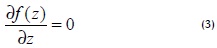
Para determinar la profundidad del flujo cero (H-z) se aplicó la metodología propuesta por León et al. (2006). Este método consiste en la minimización del error de la raíz media cuadrática (RMSE) entre el caudal estimado mediante el modelo hidrológico y un caudal estimado por medio de la ecuación 2: para un valor dado de z, los coeficientes a y b son estimados con una regresión lineal de la forma (Ln(Q), Ln(H-z)). Explorando un rango de posibilidades posibles de z se llega a construir una función del tipo RMSE (z) = f(z). Todo el posible rango de valores que pueda tener z fue explorado con incrementos de 0,01 m. El valor de z que mejor representa la altitud del flujo cero efectivo puede ser expresado como lo indica la ecuación 3.
Resultados y discusión
Series temporales de niveles de agua sobre estaciones virtuales
Las series altimétricas de las estaciones virtuales presentadas en la tabla 2 fueron sometidas a un proceso de interpolación entre el 2002 y el 2003 siguiendo la metodología propuesta por Roux et al. (2008) para la obtención de series diarias de niveles de agua. La figura 2a muestra una serie temporal de niveles de agua de una estación virtual obtenida de ALTICO. Este ejemplo corresponde a la serie de la estación 622Orinoco03 en el período 2002-2008. La figura 2b es un ejemplo del resultado del proceso de interpolación llevado a cabo para la obtención de niveles de agua medios diarios entre el 2002 y el 2003.
Estimación de caudales en las estaciones virtuales
El modelo de M-C fue aplicado en la estimación de caudales medios diarios en las estaciones virtuales. La tabla 3 sintetiza los resultados de la aplicación del modelo entre las estaciones de Puerto Nariño y Roncador para la derivación de caudales en las cuatro estaciones virtuales consideradas en el estudio.
De la tabla 3 es posible observar que en los 130 km del Orinoco considerados en este estudio no existe una influencia de importantes subcuencas con desembocadura en este tramo del río, hecho que facilita la aplicación del modelo y permite disminuir considerablemente los errores medios sobre la estimación de los caudales en las estaciones virtuales. Al final del tránsito se encuentran RMSE entre los caudales medidos y los caudales estimados inferiores al 1%. Este resultado permite concluir sobre la calidad de las series de caudales estimadas sobre las estaciones virtuales.
Curvas de calibración de estaciones virtuales y profundidad del flujo cero
Con series diarias de niveles de agua registradas a partir del espacio y los caudales obtenidos a partir de un modelo hidrodinámico fue posible deducir las curvas de gasto y las profundidades equivalentes del flujo mediante la aplicación de la metodología propuesta. La figura 3 muestra las curvas de gasto obtenidas para las cuatro estaciones virtuales consideradas en el estudio, junto con las ecuaciones que rigen dichas secciones y la profundidad media del flujo cero para cada una de ellas.
A partir de estas relaciones es posible reconstruir los caudales medios diarios de las estaciones virtuales del 2002 al 2008 y, de ahí en adelante, en las fechas en las que haya disponibilidad de datos altimétricos de la misión Envisat o su sucesor. Los coeficientes de correlación permiten concluir sobre la calidad de las funciones deducidas. Básicamente estas relaciones permitirán estimar caudales para dichas secciones a partir de registros de niveles agua diarios provenientes del espacio.
Con relación a las profundidades del flujo cero encontradas resulta indispensable la puesta en marcha de un trabajo de campo que permita validar esta información. Sin embargo, los valores encontrados se ajustan ampliamente a la realidad si tomamos como base los aforos realizados sobre las estaciones de Puerto Nariño y Roncador, donde, en promedio, se han encontrado profundidades del cauce que varían entre 12 ± 4 m y 17 ± 4m, respectivamente.
Conclusiones
Este estudio corrobora las ventajas y el uso de la altimetría radar sobre aguas continentales. La información de caudales medios diarios in situ provenientes del Ideam y aquella proveniente de la misión Envisat en relación con niveles de agua sobre estaciones virtuales ha permitido la caracterización hidráulica de dichas secciones de la misma forma en que se hace tradicionalmente, esto es, mediante la definición de curvas de gasto que permitan la estimación de caudales diarios a partir de niveles de agua y donde los coeficientes que rigen las relaciones matemáticas contienen información sobre las características hidráulicas de la sección que representan.
Se han estimado estas curvas de gasto para cuatro estaciones virtuales Envisat ubicadas entre las estaciones hidrométricas de Puerto Nariño y Roncador, representando 130 km del cauce principal del río Orinoco. El método de minimización del RMSE propuesto por León et al. (2006) permitió deducir la profundidad del flujo cero de estas cuatro secciones, que en promedio varía en 16,7 ± 4,3 m, lo que resulta consistente con los aforos realizados en las estaciones in situ mencionadas.
Esta metodología seguirá siendo aplicada en el contexto de la cuenca del Orinoco y otras cuencas del territorio colombiano definidas desde ALTICO, donde sea posible la aplicación de un modelo de tránsito que permita la estimación de caudales en las estaciones virtuales. Particularmente respecto del Orinoco será posible considerar estimación de curvas de gasto sobre los ríos Meta, Arauca y Guaviare. Esta información comenzará a ser usada por instituciones como el Ideam con dos fines básicos: densificación de las redes de monitoreo hidrológico y complemento de registros de estaciones hidrométricas. Estudios futuros darán cuenta de estas aplicaciones adicionales.
Agradecimientos
Los autores agradecen la colaboración científica y técnica aportada por los investigadores del Programa HYBAM del IRD por medio de sus laboratorios Legos y LMTG.
Referencias
Brooks, R.L., Lake elevation from satellite radar altimetry from a validation area in Canada., Reporte, Geosci. Res. 1982.
Crétaux, J.F., Birkett C., Lake studies from satellite radar altimetry Altimétrie satellitaire sur les lacs., Comptes Rendus Geo-sciences. Volume 338, 2006, Issues 14-15,
Cunge, J.A., On the subject of a flood propagation computation method (Muskingum method)., Hydraul. Res. 7 (2), 1969, 205-230.
Espinoza, J.C., Guyot, J-L., Ronchail, J., Cochonneau, G., Filizola, N., Fraizy, P., Labat, D., De Oliveira, E., Ordoñez, J,J., Vauchel, P., Contrasting regional discharge evolutions in the Amazon basin (1974-2004)., Journal of Hydrology, 2009, 375, 3-4. 297-311.
Frappart, F., Hydrologie spatiale :Développement d'applications pour l'utilisation de la télédétection sur les grands bassins fluviaux., Tesis doctoral de la Univ. Toulouse III-Paul Sabatier, 30/11/2006, 283p.
Leon J.G., Calmant S, Seyler F., Bonnet M.P., Cauhopé M., Rating curves and average water depth estimation at the upper Rio Negro from altimetric spatial data and calculated remote discharges., Journal of Hydrology, 2006, 328, 481-496.
Leon, J.G., Rubiano, J., Vargas, V., Series temporales de niveles de agua en estaciones virtuales de la Cuenca Amazónica a partir de altimetría radar por satélite., Ingeniería e Investigación. Vol 29, No. 1. 2009a., pp 109-114p.
Leon. J.G., Navarro, C., Seyler, F. Monitoreo de la hidrografía colombiana mediante la implementación de estaciones virtuales ENVISAT. Agua 2009. CINARA. Universidad del Valle. Colombia - Cali. Octubre de 2009.
Leon, J.G., Domínguez, E., Duque, G., Avances más Recientes Sobre la Aplicación de la Altimetría Radar por Satélite en Hidrología. Ingeniería e Investigación. Vol. 28 No. 3, 2008, pp 126 - 131.
León, J.G., Rubiano, J., Navarro, C.E., Estaciones hidrométricas virtuales ENVISAT en la cuenca alta y media del rio Orinoco. Ingeniería e Investigación, Universidad Nacional de Colombia, 2010 (Under review)
Mercier, F., Cazenave, A., y Maheu C., Interannual lake level fluctuations (1993-1999) in Africa from Topex/Poseidon: connections with ocean-atmosphere interactions over the Indian ocean, Global and Planetary Changes, 2002, 32, pp 141-163.
Morris, C.S., Gill,S.K., Variation of great lakes waters from Geosat altimetry., Water Resour, 1994, Res., 30:1009-1017.
Organización Meteorológica Mundial., Guía de prácticas hidrológicas. Quinta edición, OMM No 168., 1994, pp. 147-173.
Ponce, V.M., Lohani, A., Scheyhing, C., Analytical verification of Muskingum-Cunge routing., J. Hydrol. 174, 1996, pp 235- 241.
Rantz, S.E., Measurement and computation of streamflow., Measurement of Stage and Discharge, US Geological Survey Water Supply Paper, vol. 1, 1982, p. 284.
Roux, E., Cauhope, M., Bonnet, M.-P., Calmant, S., Vauchel, P., Seyler, F., Daily water stage estimated from satellite altimetric data for large river basin monitoring. Hydrol. Sci. J. 53(1), 2008. pp 81-99.
Vörösmarty, C., Birkett, C., Dingman, L., Lettenmaier, D.P., Kim, Y., Rodriguez, E., Emmitt, G., HYDRA-SAT, HYDRlogical Altimetry SATellite, NASA Post-2002 Land Surface Hydrology Mission Component for Surface Water Monitoring, report from the NASA Post-2002. Land Surface Hydrology Planning Workshop, Irvine, CA, April 12-14th, 1999.
Rating curve estimation using Envisat virtual stations on the main Orinoco river
Juan León 1, Frederique Seyler2, Astrid Puerta3
1 Ph.D., Universidad de Toulouse. Professor, Universidad Nacional de Colombia - Palmira. jgleonh@gmail.com
2 Ph.D., Universidad de Paris. Institute de Recherche pour le Developpement -IRD., France. frederique.seyler@ird.fr
3 Environmental Engineering, Master Student in Environmental Engineering, Universidad Nacional de Colombia-Palmira. astridpuertam@gmail.com
ABSTRACT
Rating curve estimation (height-stream relation) made by hydrometric stations representing cross-sections of a river is one of hydrometrics' fundamental tasks due to the fact that it leads to deducing a river's average daily flow on that particular section. This information is fundamental in any attempt at hydrological modelling. However, the number of hydrological control stations monitoring large hy-drological basins has been reduced worldwide. Space hydrology studies during the last five years have shown that satellite radar altimetry means that hydrological monitoring networks' available information can be densified due to the introduction of so-called virtual stations and the joint use of such information along with in-situ measured flow records for estimating expenditure curves at these stations.
This study presents the rating curves for 4 Envisat virtual stations located on the main stream of the Orinoco River. Virtual stations' flows were estimated by using the Muskin-gum-Cunge 1D model. There was less than 1% error between measured and estimated flows. The methodology led to reducing average zero flow depth; in this case, it led to depths ranging from 11 to 20 meters being found along the 130 km of the Orinoco River represented by the virtual stations being considered.
Keywords: biogas, oxygen enrichment, greenhouse gas, combustion property.
Received: March 5th 2010 Accepted: November 24th 2010
Introduction
Calibration or rating curves are hydrological tools which highlight the existing relationship between water level and the flow rate corresponding to that height for a given section of a river. Rating curves which are usually expressed as a power law are used to reduce average daily flows from daily water levels' on-site records taken from each station's gauges. The calibrated relationship between both variables is deducted from pairs of stage-discharge data obtained by gauging (WMO, 1994). The accuracy of the estimated daily flows is related to the quality of this ratio obtained for a particular section, in turn, depending on the number of gaugings made. However, the number of hydrometrical stations monitoring a basin's hydrological behaviour worldwide has become reduced (Vörösmarty et al., 1999; Espinoza, 2009).
This problem is even more evident in developing countries where hydrometric networks' management agencies' lack of budget hampers the installation of new stations and affects operating station maintenance and management. This then suggests the need for new tools and technologies to support continental surface waters' ongoing monitoring systems by providing support and continuation for measurements recorded in-situ, in addition to seeking densification of such control networks.
Several studies (Brooks, 1982; Morris and Gill, 1994; Mercier et al., 2002; Frappart et al., 2006; Crétaux and Birkett, 2006; Leon et al., 2009a) have shown the advantages of satellite radar altimetry in measuring changes in continental water levels. Such studies, besides presenting a detailed literature review regarding this technology, have shown how its application not only has to do with precision linked to records but also with its ability to measure instantaneous levels of water bodies, having quite acceptable spatial and time resolutions. These measurements lead to defining what are known as virtual stations, this being any intersection between satellite scanning and a continental water plan on which the recorded data infer a time series representing surface water level variations (León et al., 2008).
Altimetry for Colombia (ALTICO) has been particularly developed for this country (León et al., 2009b). It is a database containing 548 ENVISAT virtual stations concerning Colombia's entire hydrological network, including major and minor rivers, lakes, dams and flood areas.
About three years ago, Leon et al., (2006) developed and validated a methodology for estimating Envisat and Topex/Poseidon virtual stations' expenditure curves. Such methodology allows relating time series of water levels recorded by a satellite and measured or estimated flows in the virtual stations, in other words meaning estimating rating curves at these virtual stations.
This study was aimed at applying Leon et al.'s 2006 methodology for obtaining cost curves regarding some Envisat virtual stations reported by Leon et al., (In revision) in the Colombian Orinoco basin.
Material and method
Study area
The Orinoco basin has an area of around 1,015,000 km2, of which about 640,000 km2 belong to Venezuela (63% of the lower Orinoco basin). Surface runoff drains from the Andes, the upper and middle Orinoco basins in Colombia (Figure 1). The Orinoco River's 1,783 km length makes it the second largest river in South-America after the Amazon and the third longest in the world after the Congo. The Orinoco River and its tributaries represent the largest natural surface drainage system in eastern Colombia, in an area known as the Eastern Plains. The most important tributaries of the area are the Meta, Guaviare, Inirida and Vichada Rivers. Their overall contribution has been estimated at around 15,000 m3/s, accounting for nearly 50% of the Orinoco River's total flow to the Atlantic Ocean.
In-situ and altimetric information
The virtual stations used in this study were drawn from ALTICO, a database developed by the Universidad Nacional de Colombia in Palmira, containing about 550 Envisat virtual stations located on major Colombian waterways, lakes, dams and flood areas (Leon et al., 2009b). These virtual stations show time series regarding the variation in free surface water levels for a period between 2002 (mission start date) and 2008 (the date for which records were updated for the currently operating mission), measurement records being taken every 35 days (Leon et al., 2008).
ALTICO, developed entirely in Microsoft Access, has been designed to have a single tabular structure organising all the available virtual stations in Colombia, giving the following data for each one: station number, body of water to which it belongs to (river, lake, flood area, swamp ..), satellite trace number, station name, geographical coordinates, links for quick viewing of the station, link to access the data forming the time series and link to visualising the station on Google Earth.
ALTICO stores data for 120 virtual stations in the Orinoco basin, 78 of which are located on the river basin's main channels, 18 on the Guaviare River, 17 on the Meta River, 15 on the Inirida River, 9 on the Orinoco River, 8 on the Vichada River, 6 on the Arauca River and 5 on the Casanare River (Leon et al., in review). These stations are presented as white identifiers in Figure 1. The methodology proposed by Leon et al., (2006) was applied to assess altimetry series' level of precision which involved estimating the root mean square (RMS) between the virtual series and nearest in-situ series. Logically, this process is only valid when the virtual station is on an in-situ station or, alternatively, at a short distance within a section which is not affected by abrupt hydraulic changes (Leon et al., 2008). This method led to validating 20 virtual stations on the Orinoco basin, having RMS values close to 45 ± 14cm (Leon et al., in review)
Meanwhile, in-situ information was provided by the Institute of Hydrology and Environmental Meteorology and Environmental Studies in Colombia (IDEAM). Figure 1 shows the 64 hydrometric monitoring stations available for the study area (dark gray points). However, only 34 of the 64 stations are recording daily water levels regarding the basin's main channels. Only 22 of them have average daily flow records for 2002 and 2003. No stations have complete records of flows between 2002 and 2008, the period for which updated records are available at Envisat. Table 1 summarises the availability of information regarding the Orinoco Basin's main channels.
This study then focused on 4 of the 9 stations present on the Orinoco River: 493Orinoco04, 493Orinoco01, 622Orinoco04 and 622Orinoco03. The reason for selecting these stations was because they are located between two in-situ hydrometric stations which have complete records of levels and flows between 2002 and 2003, this being which they represent. The total section considered was about 130 km of the Orinoco's main channel. Table 2 summarises the characteristics regarding space distribution of the virtual and in-situ stations on the section being considered.
Flow estimation
The flows in the virtual stations were estimated by applying the Mskingum-Cunge (MC) traffic model, this being an approach based on a quasi-dynamic approximation of wave propagation (Ponce et al., 1996). The MC model (Cunge, 1969) is in fact a version that fits the Muskingum classic model, where the wellknown parameters X and K are derived from the hydraulic characteristics of a section being considered: slope in a particular section, channel width, wave speed and section length (Ponce et al., 1996).
Basically, applying the model consisted of propagating daily middle flows known for an upstream station towards a downstream station, by assuming that the propagation of wave dynamics was based on that section's hydraulic characteristics. This propagation could be done on one or more downstream sections for which the aforementioned hydraulic characteristics would already be known. For validation purposes, it was necessary to count on an average daily flow downstream to calculate estimated flow during propagation and flows measured in-situ. Leon et al. (2006) have made a complete revision of the MC model and presented its detailed application to large channels for the flow estimation by virtual Envisat stations in the Amazon Basin.
Estimating the error between estimated flow rate and measured flow was done by applying the ratio shown in Equation 1. This ratio considers mean absolute error based on the flow measured in-situ downstream of the station.
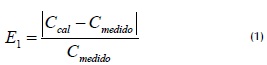
Ccal was estimated flow using the MC model, Cmeasured was daily flow rate known at the in-situ station. The MC model for the station in Puerto Nariño (upstream station) to the Roncador station (station downstream) was applied for this study, spreading flows over the virtual intermediate stations listed in Table 2.
Estimated rating curves
Due to the short period regarding available in-situ flow data (2002-2003) and that altimetry measurements were taken every 35 days, it was necessary to make a temporal interpolation for deriving daily mean water levels regarding the altimetric series to obtain pairs of height/flow data for deriving a more accurate rating curve for each virtual station. An interpolation of temporal series methodology proposed by Roux et al., (2008) was thus applied.
Series of daily water levels regarding space and flows estimated at virtual stations led to deducing these sections' rating curves (Leon et al. 2006). In effect, expressed as a power law, a rating curve can be represented by equation 2 (Rantz et al., 1982).
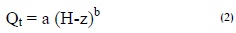
where Q was flow at time t and (Hz) was the depth of zero flow channel control section at time t. H was the height of the free surface of water measured by the satellite and continental referenced GRACE geoids and z was the height of the flow taken over the same reference. Coefficients a and b were specific to each section and represented their hydraulic characteristics (Rantz et al., 1982).
The methodology proposed by Leon et al., (2006) was used for determining the depth of zero flow (Hz). This method consists of minimising root mean square error (RMSE) between the flow estimated by the hydrological model and a flow rate estimated by Equation 2: for a given value of z, coefficients a and b were estimated by linear regression (Ln (Q), Ln (Hz)). By exploring a range of possibilities of z it was possible to construct RMSE (z) = f (z). All the possible range of values which might have had z was explored in 0.01 m increments. The value of z that best represented the altitude of zero effective flow could be expressed as shown in Equation 3.

Results and Discussion
Virtual stations' water level time series
The altimetric series for virtual stations presented in Table 2 were subjected to interpolation between 2002 and 2003, following the methodology proposed by Roux et al., (2008) to obtain a daily series of water levels. Figure 2a shows water levels time series at a virtual station obtained from ALTICO. This example refers to the 622Orinoco03 series from 2002 to 2008. Figure 2b is a sample of the result of the interpolation carried out to obtain mean daily water levels between 2002 and 2003.
Virtual stations' flow estimation
The MC model was used for estimating virtual stations' average daily flows. Table 3 summarises the results of applying the model between the Puerto Nariño and Roncador stations for deriving flows in the four virtual stations included in the study.
Table 3 shows that in the 130 km of the Orinoco River considered in this study there was no significant river sub-section influence regarding other rivers flowing into this piece of river, thereby facilitating the application of the model and significantly decreasing average errors regarding estimating flows in virtual stations. At the end of transit, RMSE below 1% were found between virtual flow rate and in situ measured flow rate. This result led to concluding that the virtual stations' quality regarding estimated flow series was good.
Calibration curves of virtual stations and depth of zero flow.
With a daily series of water levels recorded from space and flow obtained from a hydrodynamic model it was possible to deduce the equivalent rating curves and flow depths by applying the proposed methodology. Figure 3 shows the rating curves obtained for the 4 virtual stations considered in this study, along with the equations governing these sections and the average depth of zero flow for each of them.
It was possible to reconstruct the average daily flows for virtual stations from 2002 to 2008 from these ratios and thereafter the dates on which altimetric data was available from the Envisat mission or its successor. Basically, these relationships will allow estimating flows for such sections from daily water level records from space.
Regarding the zero flow depths found, field work is fundamental as it leads to validating such information. However, the values found were closely adjusted to reality in relation to the appraisals made at the Puerto Nariño and Roncador stations where, on average, channel depths ranged from 12 ± 17 ± 4m and 4m, respectively.
Conclusions
This study confirmed radar altimetry's advantages and its use regarding inland waters. The information regarding IDEAM's in-situ average daily flows and those from the Envisat mission concerning virtual stations' water levels led to the hydraulic characterisation of the sections in the same way as it is traditionally done, i.e. by defining rating curves for estimating daily flows from water levels and where the coefficients governing mathematical relationships contain information about the hydraulic characteristics of the section that they represent.
Four rating curves for ENVISAT virtual stations have been estimated, located between the Puerto Nariño and Roncador hydro-metric stations, representing 130 km of the Orinoco River's main stream. The RMSE minimisation method proposed by Leon et al., (2006) led to deducing the zero flow depth of four sections varying 16.7 ± 4.3 m on average, which was consistent with the appraisals made at the aforementioned in-situ stations.
This methodology will continue being applied for studies in the Orinoco Basin and other Colombian basins defined from ALTICO, where a traffic model can be set up for estimating flows in virtual stations. Rating curves will be made for the Meta, Arauca and Guaviare rivers. This information will begin to be used by institutions such as the IDEAM with two basic goals: hydrological monitoring network densification and complementing hydromet-ric stations' records. Future studies will document such additional applications.
Acknowledgements
The authors would like to thank researchers from the IRD's HY-BAM programme for the scientific and technical collaboration provided by their LEGOS AND LMTG laboratories.
Agradecimientos
Los autores agradecen la colaboración científica y técnica aportada por los investigadores del Programa HYBAM del IRD por medio de sus laboratorios Legos y LMTG.
References
Brooks, R.L., Lake elevation from satellite radar altimetry from a validation area in Canada., Reporte, Geosci. Res. 1982.
Crétaux, J.F., Birkett C., Lake studies from satellite radar altimetry Altimétrie satellitaire sur les lacs., Comptes Rendus Geo-sciences. Volume 338, 2006, Issues 14-15,
Cunge, J.A., On the subject of a flood propagation computation method (Muskingum method)., Hydraul. Res. 7 (2), 1969, 205-230.
Espinoza, J.C., Guyot, J-L., Ronchail, J., Cochonneau, G., Filizola, N., Fraizy, P., Labat, D., De Oliveira, E., Ordoñez, J,J., Vauchel, P., Contrasting regional discharge evolutions in the Amazon basin (1974-2004)., Journal of Hydrology, 2009, 375, 3-4. 297-311.
Frappart, F., Hydrologie spatiale :Développement d'applications pour l'utilisation de la télédétection sur les grands bassins fluviaux., Tesis doctoral de la Univ. Toulouse III-Paul Sabatier, 30/11/2006, 283p.
Leon J.G., Calmant S, Seyler F., Bonnet M.P., Cauhopé M., Rating curves and average water depth estimation at the upper Rio Negro from altimetric spatial data and calculated remote discharges., Journal of Hydrology, 2006, 328, 481-496.
Leon, J.G., Rubiano, J., Vargas, V., Series temporales de niveles de agua en estaciones virtuales de la Cuenca Amazónica a partir de altimetría radar por satélite., Ingeniería e Investigación. Vol 29, No. 1. 2009a., pp 109-114p.
Leon. J.G., Navarro, C., Seyler, F. Monitoreo de la hidrografía colombiana mediante la implementación de estaciones virtuales ENVISAT. Agua 2009. CINARA. Universidad del Valle. Colombia - Cali. Octubre de 2009.
Leon, J.G., Domínguez, E., Duque, G., Avances más Recientes Sobre la Aplicación de la Altimetría Radar por Satélite en Hidrología. Ingeniería e Investigación. Vol. 28 No. 3, 2008, pp 126 - 131.
León, J.G., Rubiano, J., Navarro, C.E., Estaciones hidrométricas virtuales ENVISAT en la cuenca alta y media del rio Orinoco. Ingeniería e Investigación, Universidad Nacional de Colombia, 2010 (Under review)
Mercier, F., Cazenave, A., y Maheu C., Interannual lake level fluctuations (1993-1999) in Africa from Topex/Poseidon: connections with ocean-atmosphere interactions over the Indian ocean, Global and Planetary Changes, 2002, 32, pp 141-163.
Morris, C.S., Gill,S.K., Variation of great lakes waters from Geosat altimetry., Water Resour, 1994, Res., 30:1009-1017.
Organización Meteorológica Mundial., Guía de prácticas hidrológicas. Quinta edición, OMM No 168., 1994, pp. 147-173.
Ponce, V.M., Lohani, A., Scheyhing, C., Analytical verification of Muskingum-Cunge routing., J. Hydrol. 174, 1996, pp 235- 241.
Rantz, S.E., Measurement and computation of streamflow., Measurement of Stage and Discharge, US Geological Survey Water Supply Paper, vol. 1, 1982, p. 284.
Roux, E., Cauhope, M., Bonnet, M.-P., Calmant, S., Vauchel, P., Seyler, F., Daily water stage estimated from satellite altimetric data for large river basin monitoring. Hydrol. Sci. J. 53(1), 2008. pp 81-99.
Vörösmarty, C., Birkett, C., Dingman, L., Lettenmaier, D.P., Kim, Y., Rodriguez, E., Emmitt, G., HYDRA-SAT, HYDRlogical Altimetry SATellite, NASA Post-2002 Land Surface Hydrology Mission Component for Surface Water Monitoring, report from the NASA Post-2002. Land Surface Hydrology Planning Workshop, Irvine, CA, April 12-14th, 1999.
References
Brooks, R.L., Lake elevation from satellite radar altimetry from a validation area in Canada., Reporte, Geosci. Res. 1982.
Crétaux, J.F., Birkett C., Lake studies from satellite radar altimetry Altimétrie satellitaire sur les lacs., Comptes Rendus Geo-sciences. Volume 338, 2006, Issues 14-15. DOI: https://doi.org/10.1016/j.crte.2006.08.002
Cunge, J.A., On the subject of a flood propagation computation method (Muskingum method)., Hydraul. Res. 7 (2), 1969, 205-230. DOI: https://doi.org/10.1080/00221686909500264
Espinoza, J.C., Guyot, J-L., Ronchail, J., Cochonneau, G., Filizola, N., Fraizy, P., Labat, D., De Oliveira, E., Ordoñez, J, J., Vauchel, P., Contrasting regional discharge evolutions in the Amazon basin (1974-2004)., Journal of Hydrology, 2009, 375, 3-4. 297-311. DOI: https://doi.org/10.1016/j.jhydrol.2009.03.004
Frappart, F., Hydrologie spatiale :Développement d'applications pour l'utilisation de la télédétection sur les grands bassins fluviaux., Tesis doctoral de la Univ. Toulouse III-Paul Sabatier, 30/11/2006, 283p.
Leon J.G., Calmant S, Seyler F., Bonnet M.P., Cauhopé M., Rating curves and average water depth estimation at the upper Rio Negro from altimetric spatial data and calculated remote discharges., Journal of Hydrology, 2006, 328, 481-496. DOI: https://doi.org/10.1016/j.jhydrol.2005.12.006
León, J.G., Rubiano, J., Vargas, V., Series temporales de niveles de agua en estaciones virtuales de la Cuenca Amazónica a partir de altimetría radar por satélite., Ingeniería e Investigación. Vol. 29, No. 1. 2009a., pp 109-114p.
León. J.G., Navarro, C., Seyler, F. Monitoreo de la hidrografía colombiana mediante la implementación de estaciones virtuales ENVISAT. Agua 2009. CINARA. Universidad del Valle. Colombia - Cali. Octubre de 2009.
León, J.G., Domínguez, E., Duque, G., Avances más Recientes Sobre la Aplicación de la Altimetría Radar por Satélite en Hidrología. Ingeniería e Investigación. Vol. 28 No. 3, 2008, pp 126 - 131. DOI: https://doi.org/10.15446/ing.investig.v28n3.15131
León, J.G., Rubiano, J., Navarro, C.E., Estaciones hidrométricas virtuales ENVISAT en la cuenca alta y media del rio Orinoco. Ingeniería e Investigación, Universidad Nacional de Colombia, 2010 (Under review).
Mercier, F., Cazenave, A., y Maheu C., Interannual lake level fluctuations (1993-1999) in Africa from Topex/Poseidon: connections with ocean-atmosphere interactions over the Indian ocean, Global and Planetary Changes, 2002, 32, pp 141-163. DOI: https://doi.org/10.1016/S0921-8181(01)00139-4
Morris, C.S., Gill, S.K., Variation of great lakes waters from Geosat altimetry., Water Resour, 1994, Res., 30:1009-1017. DOI: https://doi.org/10.1029/94WR00064
Organización Meteorológica Mundial., Guía de prácticas hidrológicas. Quinta edición, OMM No 168., 1994, pp. 147-173.
Ponce, V.M., Lohani, A., Scheyhing, C., Analytical verification of Muskingum-Cunge routing., J. Hydrol. 174, 1996, pp 235- 241. DOI: https://doi.org/10.1016/0022-1694(95)02765-3
Rantz, S.E., Measurement and computation of streamflow., Measurement of Stage and Discharge, US Geological Survey Water Supply Paper, vol. 1, 1982, p. 284.
Roux, E., Cauhope, M., Bonnet, M.-P., Calmant, S., Vauchel, P., Seyler, F., Daily water stage estimated from satellite altimetric data for large river basin monitoring. Hydrol. Sci. J. 53(1), 2008. pp 81-99. DOI: https://doi.org/10.1623/hysj.53.1.81
Vörösmarty, C., Birkett, C., Dingman, L., Lettenmaier, D.P., Kim, Y., Rodriguez, E., Emmitt, G., HYDRA-SAT, HYDRlogical Altimetry SATellite, NASA Post-2002 Land Surface Hydrology Mission Component for Surface Water Monitoring, report from the NASA Post-2002. Land Surface Hydrology Planning Workshop, Irvine, CA, April 12-14th, 1999.
How to Cite
APA
ACM
ACS
ABNT
Chicago
Harvard
IEEE
MLA
Turabian
Vancouver
Download Citation
CrossRef Cited-by
1. Aryan Salvati, Alireza Moghaddam Nia, Ali Salajegheh, Ataollah Shirzadi, Himan Shahabi, Ebrahim Ahmadisharaf, Dawei Han, John J Clague. (2024). A systematic review of Muskingum flood routing techniques. Hydrological Sciences Journal, 69(6), p.810. https://doi.org/10.1080/02626667.2024.2324132.
2. Rossella Belloni, Stefania Camici, Angelica Tarpanelli. (2021). Towards the continuous monitoring of the extreme events through satellite radar altimetry observations. Journal of Hydrology, 603, p.126870. https://doi.org/10.1016/j.jhydrol.2021.126870.
Dimensions
PlumX
Article abstract page views
Downloads


License
Copyright (c) 2011 Juan León, Frederique Seyler, Astrid Puerta

This work is licensed under a Creative Commons Attribution 4.0 International License.
The authors or holders of the copyright for each article hereby confer exclusive, limited and free authorization on the Universidad Nacional de Colombia's journal Ingeniería e Investigación concerning the aforementioned article which, once it has been evaluated and approved, will be submitted for publication, in line with the following items:
1. The version which has been corrected according to the evaluators' suggestions will be remitted and it will be made clear whether the aforementioned article is an unedited document regarding which the rights to be authorized are held and total responsibility will be assumed by the authors for the content of the work being submitted to Ingeniería e Investigación, the Universidad Nacional de Colombia and third-parties;
2. The authorization conferred on the journal will come into force from the date on which it is included in the respective volume and issue of Ingeniería e Investigación in the Open Journal Systems and on the journal's main page (https://revistas.unal.edu.co/index.php/ingeinv), as well as in different databases and indices in which the publication is indexed;
3. The authors authorize the Universidad Nacional de Colombia's journal Ingeniería e Investigación to publish the document in whatever required format (printed, digital, electronic or whatsoever known or yet to be discovered form) and authorize Ingeniería e Investigación to include the work in any indices and/or search engines deemed necessary for promoting its diffusion;
4. The authors accept that such authorization is given free of charge and they, therefore, waive any right to receive remuneration from the publication, distribution, public communication and any use whatsoever referred to in the terms of this authorization.